Opportunity Route Map |

  |
Opportunity Route Map |
| Guest_Sunspot_* |
 Oct 24 2005, 02:06 PM Oct 24 2005, 02:06 PM
Post
#826
|
|
Guests |
I wonder if they will avoid the immediate rim of Erebus entirely? It looks like there may be a smoother area a little way out from the rim which continues south - it appears as slightly darker patches in the picture Tesheiner posted.
|
 |
 
|
|
Oct 24 2005, 02:12 PM
Post
#827
|
||
|
Solar System Cartographer  Group: Members Posts: 10151 Joined: 5-April 05 From: Canada Member No.: 227 |
Here's a polar pan as requested... I've been too busy to do many lately even though we keep getting these wonderful pans, especially from jvandriel (original author of this one).
This is the 'four lane highway' area. Opportunity is now NW of it. Notice all the fractures in the bedrock. None of them can be traced very far from outcrop to outcrop. They are perhaps more like joints than faults, small local fractures without a coherent regional pattern. Phil
PS I edited steps out of the horizon before making this. -------------------- ... because the Solar System ain't gonna map itself.
Also to be found posting similar content on https://mastodon.social/@PhilStooke Maps for download (free PD: https://upload.wikimedia.org/wikipedia/comm...Cartography.pdf NOTE: everything created by me which I post on UMSF is considered to be in the public domain (NOT CC, public domain) |
|
|
|
|
|
|
Oct 24 2005, 08:22 PM
Post
#828
|
|
|
Senior Member Group: Moderator Posts: 4279 Joined: 19-April 05 From: .br at .es Member No.: 253 |
QUOTE (Tesheiner @ Oct 24 2005, 03:12 PM) Until Oppy don't reach the next patch of rock, I will try to pinpoint the rover position based on the headings to that little crater looking west. Here below is a first trial based on sol 621 data (the base image is the same I used some weeks ago when talking about possible paths to Mogollon). The headings can be obtained from pancam images 1P183318548EFF63IRP2406L2M1 and 1P183318548EFF63IRP2406R2M1. That shot was taken with the camera pointed exactly at -90º (info from pancam tracking web) so the headings to the crater rim are: 90 + 2.01º and 90 - 3.07º. Rover positions using this method may have significant errors, but at least they are not cummulative. Edited: Simply disregard this post. I've just downloaded the missing navcam images for sol 621, and a quick parallax measurement places that drive on the 15m range -- a half of what I calculated with the headings to the crater.  I'm still wondering why that method to pinpoint Oppy's location didn't word, but couldn't find the mistake. Comments are welcome. |
|
|
|
|
Oct 24 2005, 09:02 PM
Post
#829
|
||
|
Senior Member Group: Members Posts: 1636 Joined: 9-May 05 From: Lima, Peru Member No.: 385 |
Thanks Phil,
Might I take your polar drawing pictures until when you are back? What software do you use to create it? What are the input for this drawing? Is that rather complicated process or not? New Oppy's position in polar orientation format. (needs one more recent). About last Tesheiner's post. What I pay the attention is that the value of 90 degree, the horizontal line going to EAST is not valid here unless it is officially stated. If it is official, then we can start measure the angle from here as good reference.
Attached thumbnail(s)
|
|
|
|
|
|
|
Oct 24 2005, 11:17 PM
Post
#830
|
|
|
Solar System Cartographer Group: Members Posts: 10151 Joined: 5-April 05 From: Canada Member No.: 227 |
RNeuhaus, look here:
http://www.unmannedspaceflight.com/index.php?showtopic=1075 for a description of the process. I was not quite sure what your first question means. You are welcome to use anything I post here. Phil -------------------- ... because the Solar System ain't gonna map itself.
Also to be found posting similar content on https://mastodon.social/@PhilStooke Maps for download (free PD: https://upload.wikimedia.org/wikipedia/comm...Cartography.pdf NOTE: everything created by me which I post on UMSF is considered to be in the public domain (NOT CC, public domain) |
|
|
|
|
Oct 25 2005, 01:32 AM
Post
#831
|
||
 Senior Member Group: Members Posts: 2492 Joined: 15-January 05 From: center Italy Member No.: 150 |
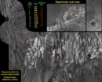
It seems Oppy covered a very long distance on Sol 621. I updated the MGS image using last one taken on 5 October (more detailed).
As feared by Tesheiner, precise identidication of Rover position in the satellite map isn't easy, i tried to do my best but for sure is not precise... 
Attached thumbnail(s)
-------------------- I always think before posting! - Marco -
|
|
|
|
|
|
|
Oct 25 2005, 08:20 AM
Post
#832
|
|
|
Senior Member Group: Moderator Posts: 4279 Joined: 19-April 05 From: .br at .es Member No.: 253 |
QUOTE (RNeuhaus @ Oct 24 2005, 11:02 PM) About last Tesheiner's post. What I pay the attention is that the value of 90 degree, the horizontal line going to EAST is not valid here unless it is officially stated. If it is official, then we can start measure the angle from here as good reference. That 90º value was taken from the MER Pancam Data Tracking Web Interface and more then official it can be considered "internal" (or technical) information. That was the heading programmed to the pancam when taking the first of four shots of what is usually called "drive direction panorama". -1.57071 is the heading in radians; look it yourself and you will see a series of four shots, the first pointing at -90º and the next three ones with a clockwise added delta of 13.333º. --- Expected EDRs by sequence number and image type: Sol Seq.Ver ETH ESF EDN EFF ERP Tot Description --- -------- --- --- --- --- --- ---- ----------- 621 p0755.03 10 0 0 10 0 20 navcam_5x1_az_270_3_bpp 621 p1212.02 2 0 0 2 0 4 front_haz_ultimate_2_bpp ... 621 p1600.01 20 0 0 20 0 40 navcam_10x1_az_0_1_bpp 621 p1655.01 10 0 0 10 0 20 navcam_5x1_az_90_1_bpp 621 p2124.03 3 3 0 0 1 7 pancam_cal_targ_L456 621 p2406.06 8 0 0 8 2 18 pancam_drive_direction_4x1_L2R2 ... Summary for: bp2406.06a.pancam_drive_direction_4x1_L2R2.rml: ETH ESF EDN EFF EHG ERS ECS ERP Total ---- ---- ---- ---- ---- ---- ---- ---- ----- 8 0 0 8 0 0 0 2 18 Duration (hhmmss) = 00:10:43 Data Vol (Mbits) = 24.28 --------------------------- bp2406.06a.pancam_drive_direction_4x1_L2R2.rml: --------------------------- cmdname pri id img hist rsum csum ref lcam rcam frm c1 c2 c3 frmarg lflt rflt acq shut exp lscl rscl lexp rexp ltbl rtbl updt thres pxfrc iter perc bdpx flat subf rstrt cstrt nr nc dwnsmp ph pw pxscl comp bpp minls wfilt ndcmp nseg RUN_FILTER_POS LPAN 7 RUN_FILTER_HOME LPAN CCW RUN_FILTER_POS RPAN 7 RUN_FILTER_HOME RPAN CCW CAPTURE_IMAGE 26 1000001 TRUE FALSE FALSE FALSE TRUE LPAN RPAN LVL_AZ -1.57071 -0.09599 0.0 NA PANL2 PANR2 LIVE COND AUTO 1 1 50 50 ARG ARG TRUE 2500 1 6 10 FALSE FALSE NONE 0 0 1024 1024 NONE 1 1 NONE ICER 3 0 A 4 20 CAPTURE_IMAGE 26 1000002 TRUE FALSE FALSE FALSE FALSE LPAN RPAN LVL_AZ -1.33806 -0.09599 0.0 NA PANL2 PANR2 LIVE COND AUTO 1 1 50 50 LPAN2 RPAN2 TRUE 2500 1 6 10 FALSE FALSE NONE 0 0 1024 1024 NONE 1 1 NONE ICER 3 0 A 4 20 CAPTURE_IMAGE 26 1000003 TRUE FALSE FALSE FALSE FALSE LPAN RPAN LVL_AZ -1.1054 -0.09599 0.0 NA PANL2 PANR2 LIVE COND AUTO 1 1 50 50 LPAN2 RPAN2 TRUE 2500 1 6 10 FALSE FALSE NONE 0 0 1024 1024 NONE 1 1 NONE ICER 3 0 A 4 20 CAPTURE_IMAGE 26 1000004 TRUE FALSE FALSE FALSE FALSE LPAN RPAN LVL_AZ -0.87275 -0.09599 0.0 NA PANL2 PANR2 LIVE COND AUTO 1 1 50 50 LPAN2 RPAN2 TRUE 2500 1 6 10 FALSE FALSE NONE 0 0 1024 1024 NONE 1 1 NONE ICER 3 0 A 4 20 --- |
|
|
|
|
Oct 25 2005, 08:24 AM
Post
#833
|
|
|
Senior Member Group: Moderator Posts: 4279 Joined: 19-April 05 From: .br at .es Member No.: 253 |
QUOTE (dilo @ Oct 25 2005, 03:32 AM) It seems Oppy covered a very long distance on Sol 621. I updated the MGS image using last one taken on 5 October (more detailed). As feared by Tesheiner, precise identidication of Rover position in the satellite map isn't easy, i tried to do my best but for sure is not precise... A 31.8m drive Dilo? If that's correct (and it looks like) my last attempt to pinpoint the rover position was successful. I will continue doing that. |
|
|
|
|
Oct 25 2005, 08:46 AM
Post
#834
|
|
|
Senior Member Group: Members Posts: 2998 Joined: 30-October 04 Member No.: 105 |
That is plausible. Evidently Opppy is taking a long run up a ripple trough to get around the loose sand north of that last dune complex. I fear that we won't have much to go by for post-drive route positioning; the only landmarks are that lone small crater to the West and whatever Erebus features we can triangulate back to. Dilo and Tesheiner are doing the best with what they have to work with.
Here is my current route chart; I think that Oppy will soon turn back around and head Southwest toward the Western rim of Erebus. --Bill -------------------- |
|
|
|
|
Oct 25 2005, 10:08 AM
Post
#835
|
|||
|
Senior Member Group: Moderator Posts: 4279 Joined: 19-April 05 From: .br at .es Member No.: 253 |
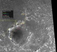
I did another exercise to locate Oppy position (sol 621) and here are the results. In a glace, it confirms my previous attempt just checking for that small crater.
On this new attempt I used the headings to the following points: A - Crater to the west B - Bright outcrop (probably the next waypoint on Oppy's route) C - Mogollon D - Oppy's previous position
The basis for calculating the headings to those significant points was jvandriel's panorama for that sol (on Erebus thread), here below with some annotations, but if you really want to see that features I suggest to use the original navcam images.
Dilo, a comment to your route map. Have a look to my proposed position for sols 619 and 621 and compare with the ones on your map; there is a significant difference on the headings. The rover tracks on your last map are positioned at about 30º NNW while on mine they are at about 7º -- nearly north. I'm now quite confident of that positions and it looks like the reason for that discrepancy on the headings is that your map is accumulating errors. Do you remember that discussion on the Spirit Route Map thread about the methods to plot a route map? The stitching of sol 621 vertical projection on the map is very good, but day after day such a process propagate its small errors to the future. I have the impression that the map is a bit rotated counter-clockwise. |
||
|
|
|
||
|
Oct 25 2005, 11:09 AM
Post
#836
|
||
 Member Group: Members Posts: 562 Joined: 29-March 05 Member No.: 221 |
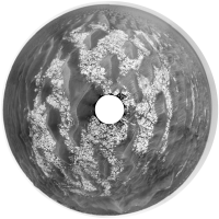
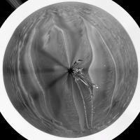
Polar Projection of the sol 621 pan. Be gentle it's my first one. I have finally finished my MA Dissertation (submitted yesterday) so have time to learn some p'shop, PTgui, Autostitch etc... skills.
Bows head to the master image processors who inhabit this board. I have some catching up to do.
Attached thumbnail(s)
|
|
|
|
|
|
|
Oct 25 2005, 12:54 PM
Post
#837
|
|
 Senior Member Group: Members Posts: 1084 Joined: 19-February 05 From: Close to Meudon Observatory in France Member No.: 172 |
 Thanks Paxdan : nice (and funny) image ! Thanks Paxdan : nice (and funny) image !Wow ! We are no more on Mars : this is Dune ! Now, be careful for rover moves, please. Some giant worms may be around... |
|
|
|
|
Oct 25 2005, 01:13 PM
Post
#838
|
|
|
Solar System Cartographer Group: Members Posts: 10151 Joined: 5-April 05 From: Canada Member No.: 227 |
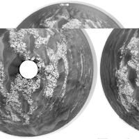
paxdan - nice one! If you add a bit of white space at the bottom of the pan before you do the polar projection you will avoid that over-compressed impression at the centre.
Phil -------------------- ... because the Solar System ain't gonna map itself.
Also to be found posting similar content on https://mastodon.social/@PhilStooke Maps for download (free PD: https://upload.wikimedia.org/wikipedia/comm...Cartography.pdf NOTE: everything created by me which I post on UMSF is considered to be in the public domain (NOT CC, public domain) |
|
|
|
|
Oct 25 2005, 02:33 PM
Post
#839
|
||
|
Member Group: Members Posts: 562 Joined: 29-March 05 Member No.: 221 |
QUOTE (Phil Stooke @ Oct 25 2005, 02:13 PM) paxdan - nice one! If you add a bit of white space at the bottom of the pan before you do the polar projection you will avoid that over-compressed impression at the centre. Phil Thanks Phil, here is a modified version which has also been pinched to alter the perspective.
|
|
|
|
|
|
|
Oct 25 2005, 04:29 PM
Post
#840
|
|
|
Senior Member Group: Members Posts: 1636 Joined: 9-May 05 From: Lima, Peru Member No.: 385 |
QUOTE (paxdan @ Oct 25 2005, 06:09 AM) Polar Projection of the sol 621 pan. Be gentle it's my first one. I have finally finished my MA Dissertation (submitted yesterday) so have time to learn some p'shop, PTgui, Autostitch etc... skills. Bows head to the master image processors who inhabit this board. I have some catching up to do. Paxdan, Good work!  Thanks to Phil to share his knowledge of that technique. Thanks to Phil to share his knowledge of that technique.Rodolfo |
|
|
|
|

|
Lo-Fi Version | Time is now: 25th April 2024 - 06:53 PM |
|
RULES AND GUIDELINES Please read the Forum Rules and Guidelines before posting. IMAGE COPYRIGHT |
OPINIONS AND MODERATION Opinions expressed on UnmannedSpaceflight.com are those of the individual posters and do not necessarily reflect the opinions of UnmannedSpaceflight.com or The Planetary Society. The all-volunteer UnmannedSpaceflight.com moderation team is wholly independent of The Planetary Society. The Planetary Society has no influence over decisions made by the UnmannedSpaceflight.com moderators. |
SUPPORT THE FORUM Unmannedspaceflight.com is funded by the Planetary Society. Please consider supporting our work and many other projects by donating to the Society or becoming a member. |
|