The Mountains of Titan, Recent article in Icarus |

The Mountains of Titan, Recent article in Icarus |
 Aug 13 2007, 06:46 PM Aug 13 2007, 06:46 PM
Post
#1
|
|
 Senior Member  Group: Moderator Posts: 2785 Joined: 10-November 06 From: Pasadena, CA Member No.: 1345 |
Recently released article on RADAR interpretations of Titan's mountains.
"Mountains of Titan observed by Cassini Radar" J. Radebaugh, R. Lorenz, R. Kirk, J. Lunine, E.R. Stofan, R. Lopes, S. Wall Icarus (2007) doi:10.1016/j.icarus.2007.06.020 [Only accessible via Icarus website? I have no clue how to link to a free abstract. Sorry, y'all!] This is the full paper following the 2006 LPS abstract (which is freely available): Radebaugh et al LPS 37 (2006) Abstract 1007. Mountains on Titan Observed by Cassini Radar. Abstract freely available here. -Mike -------------------- Some higher resolution images available at my photostream: http://www.flickr.com/photos/31678681@N07/
|
 |
 
|
 |
|
Sep 23 2007, 05:45 AM
Post
#2
|
||||
|
Senior Member Group: Moderator Posts: 2785 Joined: 10-November 06 From: Pasadena, CA Member No.: 1345 |
The flanks of the T28 Tectonic Ridges do not show feeder streams. Why not?
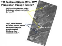
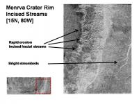
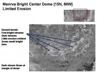
The incised ridge tops of the T28 Tectonic Ridge provide evidence for severe erosion. In addition, the the lower valleys show broad and short stream basins. Yet we do not see any intermediate feeder channels. The lower streams resemble the pattern seen in saturated muds like in a slough. Compare this with the Menrva crater rim, which is at the same latitude. The rim is deeply incised with stream patterns. In the figure at right, the central dome of Menrva shows limited erosion. It seems that the central dome is more resistant to erosion than the rim. Either the T28 ridges were covered in material after erosion had taken place, or the rain is able to rapidly percolate through the mantling organic material without causing erosion. Since it is at the same latitude as the Menrva crater rim, it seems likely that the rain that carved the Menrva rim also fell on the T28 Tectonic Ridges. Thus it seems that the rain is able to percolate through the organic mantle, perhaps flowing as undermantle streams until it hits the valleys and has sufficient volume and flow to clear the valley streambeds of gook. -Mike -------------------- Some higher resolution images available at my photostream: http://www.flickr.com/photos/31678681@N07/
|
|||
|
|
|
|||
 Juramike The Mountains of Titan Aug 13 2007, 06:46 PM
 belleraphon1 Mike...
Evocative name for a thread.
Hope ther... Aug 14 2007, 12:08 AM elakdawalla I haven't gotten my hands on a copy of the pap... Aug 14 2007, 02:06 AM remcook This article is still in press and so it will take... Aug 14 2007, 09:12 AM David Is it more likely that these mountains overlay a h... Aug 15 2007, 02:07 AM Juramike I took a section of the N Fensal RADAR mosaic that... Sep 17 2007, 07:53 PM Juramike In the article, Radebaugh et al describes tectonic... Sep 17 2007, 10:49 PM Juramike The E-W Mountains on Titan are due to compessional... Oct 11 2008, 12:59 PM ngunn Interesting! "Titan is the only icy moon ... Oct 11 2008, 01:27 PM
belleraphon1 Mike...
Evocative name for a thread.
Hope ther... Aug 14 2007, 12:08 AM elakdawalla I haven't gotten my hands on a copy of the pap... Aug 14 2007, 02:06 AM remcook This article is still in press and so it will take... Aug 14 2007, 09:12 AM David Is it more likely that these mountains overlay a h... Aug 15 2007, 02:07 AM Juramike I took a section of the N Fensal RADAR mosaic that... Sep 17 2007, 07:53 PM Juramike In the article, Radebaugh et al describes tectonic... Sep 17 2007, 10:49 PM Juramike The E-W Mountains on Titan are due to compessional... Oct 11 2008, 12:59 PM ngunn Interesting! "Titan is the only icy moon ... Oct 11 2008, 01:27 PM Juramike QUOTE linkback: http://www.unmannedspaceflight.com... Oct 13 2008, 10:24 PM
 |

|
Lo-Fi Version | Time is now: 29th April 2024 - 05:24 AM |
|
RULES AND GUIDELINES Please read the Forum Rules and Guidelines before posting. IMAGE COPYRIGHT |
OPINIONS AND MODERATION Opinions expressed on UnmannedSpaceflight.com are those of the individual posters and do not necessarily reflect the opinions of UnmannedSpaceflight.com or The Planetary Society. The all-volunteer UnmannedSpaceflight.com moderation team is wholly independent of The Planetary Society. The Planetary Society has no influence over decisions made by the UnmannedSpaceflight.com moderators. |
SUPPORT THE FORUM Unmannedspaceflight.com is funded by the Planetary Society. Please consider supporting our work and many other projects by donating to the Society or becoming a member. |
|