Galileo images and mosaics of Europa |

  |
Galileo images and mosaics of Europa |
 Feb 12 2014, 10:59 AM Feb 12 2014, 10:59 AM
Post
#136
|
|
 Interplanetary Dumpster Diver  Group: Admin Posts: 4404 Joined: 17-February 04 From: Powell, TN Member No.: 33 |
Wow, impressive. I know what you had to work with.
-------------------- |
 |
 
|
|
Feb 12 2014, 02:19 PM
Post
#137
|
|
 Member Group: Members Posts: 796 Joined: 27-February 08 From: Heart of Europe Member No.: 4057 |
Beautiful result for such noisy data. I'm looking forward to your map of Europa!
-------------------- |
|
|
|
|
Apr 25 2014, 02:12 PM
Post
#138
|
|||||
 IMG to PNG GOD Group: Moderator Posts: 2251 Joined: 19-February 04 From: Near fire and ice Member No.: 38 |
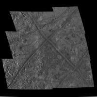
Conamara Chaos revisited
Conamara Chaos was particularly well observed by Galileo. Others (especially machi) have posted great versions of the E12 hi-res images so here I'm concentrating on the E6 images plus the E12 color images. Here is a 2x3 mosaic from a range of 19000 km. It shows all of Conamara Chaos below the big "X" feature:
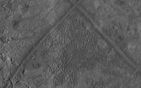
About 40 minutes later Galileo obtained four hi-res images of southern Conamara Chaos from a range of 6600 km. Here they have been blended into the big mosaic. This version shows all of Conamara Chaos:
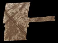
During orbit E12 Galileo obtained the well known ultra hi-res images that have appeared earlier in this thread. But it also imaged Conamara Chaos in violet, green, 756 nm and 968 nm from a range of 18000 km. This is an RGB version from the 756 nm, green and violet images:
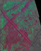
I had to create a synthetic 756 nm image from green and violet for the center of the "X" feature and everything above it but this worked very well when I used a non-linear formula instead of the more common w*GR+(1-w)*VI. I then created synthetic red and blue images. It's interesting to combine the color data with higher resolution data. This was posted way back in 2006 (!) by vexgizmo: QUOTE (vexgizmo @ Jan 21 2006, 09:44 PM)  Here's a challenge that I hope one of you might accept. During the E12 Galileo orbit, there was a sequence of Galileo color images obtained of Conamara Chaos. Below is work by the Galileo SSI team to assemble these into color mosaics. This color imaging is enough to paint much of the famous E6 Conamara Chaos mosaic in true color (or near-true color extrapolated from 2 colors)--unfortunately we still only see this region painted by false bluish color based only on the E4 Europa albedo images. Can someone accept the challenge of painting Conamara with its true E12 color? Others have done a very good job with the true color earlier in this thread so I'm not repeating that (even the very hi-res E12 images have been nicely colorized). But I noticed that there seemed to be some very subtle color variations and it is also well known that the dark terrain is redder than the light terrain. I wanted to clearly show these color variations and after some experimentation I came up with the following image where the IR756/green ratio is displayed as red, green simply as green and the violet/green ratio as blue. I then used this to colorize the E6 data (both the hi-res data and the lower resolution data):
The features that appear red or purple are 'redder' than the greenish/cyan terrain. This reveals lots of interesting things. One particularly interesting observation is that the matrix in Conamara Chaos is usually redder than the large blocks with ridged terrain. A look at page 267 in Europa published by University of Arizona Press (a must-have for anyone seriously interested in Europa) confirms this. Another interesting thing is the Pwyll ejecta. The two grayscale images near the top of the post show a north-south ray of bright ejecta material from Pwyll that overlaps western Conamara Chaos (this ejecta is particularly obvious in the G2 global image). In the false color image the westernmost part of Conamara Chaos has a strong green color caused by the ejecta. What I find interesting is that in this area both the matrix and the rafts are green. Is this evidence that Pwyll is younger than Conamara Chaos? At least I think I have managed to find a particularly good example of just how useful color/multispectral data can be. All of the images above are in orthographic projection with the subspacecraft point at lat=11.5, lon=273. North is up. The images here are slightly bigger than the originals to avoid loss of details from the many resampling and reprojection steps. |
||||
|
|
|
||||
|
Apr 25 2014, 08:48 PM
Post
#139
|
|
|
Interplanetary Dumpster Diver Group: Admin Posts: 4404 Joined: 17-February 04 From: Powell, TN Member No.: 33 |
Lovely work! I'll also add that the shapes of Galileo mosaics are sort of a signature.
-------------------- |
|
|
|
|
Apr 26 2014, 02:43 AM
Post
#140
|
|
 Member Group: Members Posts: 399 Joined: 28-August 07 From: San Francisco Member No.: 3511 |
Thanks for sharing...what a wonderful tour of jigsaw junction...
-------------------- 'She drove until the wheels fell off...'
|
|
|
|
|
Sep 5 2014, 08:08 PM
Post
#141
|
|
 Member Group: Members Posts: 207 Joined: 6-March 07 From: houston, texas Member No.: 1828 |
QUOTE (machi @ Nov 1 2011, 12:39 AM) Thanks, Accuracy of the stereograms Fig.5 and Fig.6 is dependent on the precision of my eyes and my experience. Stereograms are made by warping in Sqirlz Morph using manually added control points. With these images, I achieved my personal record - more than 1800 control points. "I have now 'discovered' that there actually is stereo coverage of Conamara Chaos but unfortunately it's not the very hi-res E12 stuff - it's E6 images from ~19000 and ~6600 km." I used image, 7513R from orbit E6. This image covers whole mosaic, so theoretically whole mosaic can be done in stereo with similar results to Fig.5/6. "And finally let's not forget this great stuff from Paul Schenk:" Yes, I know his masterful work, after all Paul Schenk is guru of DEM models. This is reason why I'm doing stereograms and not DEMs.  I made little comparison, with similar geometry, between stereogram from two images with ~same resolution (1900 and 1913 from orbit E12, Fig.3) and manually warped version (Fig.5), so you can judge both versions. Fig.3 is right image and Fig.5 is left image. always nice to see these products get some attention! be in known that i am finally (!) at last putting the stereo and PC DEM story of Europa together for submission later this year, complete with a web page of jpegs and the like. it will take 2-3 months of work to get everything ready for release but it should be pretty cool. soon . . . ! -------------------- Dr. Paul Schenk, Lunar and Planetary Institute, Houston TX
http://stereomoons.blogspot.com; http://www.youtube.com/galsat400; http://www.lpi.usra.edu/science/schenk/ |
|
|
|
|
Nov 21 2014, 08:14 PM
Post
#142
|
|
|
Interplanetary Dumpster Diver Group: Admin Posts: 4404 Joined: 17-February 04 From: Powell, TN Member No.: 33 |
NASA has released an exquisite new version of Galileo's best global view of Europa along with a nice promo video for exploring it.
-------------------- |
|
|
|
|
Nov 30 2014, 05:32 PM
Post
#143
|
||
|
IMG to PNG GOD Group: Moderator Posts: 2251 Joined: 19-February 04 From: Near fire and ice Member No.: 38 |
It is a pleasant surprise to see this released after all these years. This is a very high quality mosaic, the best version from these particular source images that I have seen. A very 'clean' image and the color channels are perfectly aligned (I sometimes need to warp indvidual color channels slightly to get rid of small 'residual' alignment errors when processing color images). The color isn't as realistic here as in Ted's version though since the red channel is from near-IR images and this is not corrected for (at least not fully).
For comparison, here is a test render from a 20000x10000 pixel true color global map I'm working on. It's shaded using a slightly modified Hapke function:
As should be obvious, this is not the final version of the map. The poles look strange and the color may change a bit in later versions, at least in the northern hemisphere near the terminator. Actually it is remarkably difficult to create a global true color map of Europa. The surface contrast varies with phase angle (less contrast at low phase angles) and the color also varies with changes in viewing/illumination geometry. Or in other words, the photometric parameters vary with wavelength. For example limb darkening increases with increasing wavelength. I haven't found any information on exactly how the Hapke photometric parameters vary with wavelength but if I find information on this (or figure out myself how the parameters vary) I should be able to render more realistic views of Europa uisng the big map I'm working on. QUOTE (DrShank @ Sep 5 2014, 08:08 PM) always nice to see these products get some attention! be in known that i am finally (!) at last putting the stereo and PC DEM story of Europa together for submission later this year, complete with a web page of jpegs and the like. it will take 2-3 months of work to get everything ready for release but it should be pretty cool. soon . . . ! It will be very interesting to see this. |
|
|
|
|
|
|
Dec 20 2014, 10:51 PM
Post
#144
|
||
|
IMG to PNG GOD Group: Moderator Posts: 2251 Joined: 19-February 04 From: Near fire and ice Member No.: 38 |
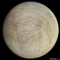
One by-product from the 20000x10000 global map of Europa I'm working on is that I now have a global true color map from all of the useful color images that have a resolution ranging from ~1.2 km/pixel to ~15 km/pixel and this can be used to colorize clear filter images and mosaics. Here is a colorized version of the I25 mosaic in this post. The color is mainly from the C9 global image but a bit also comes from G2.
The color should be fairly close to Europa's true color. |
|
|
|
|
|
|
Dec 21 2014, 12:24 AM
Post
#145
|
|
|
Merciless Robot Group: Admin Posts: 8784 Joined: 8-December 05 From: Los Angeles Member No.: 602 |
Gorgeous, Bjorn.

-------------------- A few will take this knowledge and use this power of a dream realized as a force for change, an impetus for further discovery to make less ancient dreams real.
|
|
|
|
|
Dec 22 2014, 02:41 AM
Post
#146
|
|
|
Junior Member Group: Members Posts: 95 Joined: 5-September 07 Member No.: 3662 |
Speechless
|
|
|
|
|
Feb 2 2015, 10:40 PM
Post
#147
|
||
|
IMG to PNG GOD Group: Moderator Posts: 2251 Joined: 19-February 04 From: Near fire and ice Member No.: 38 |
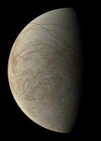
Today, it seems that NASA is at last committing to flying a mission (probably Europa Clipper) to Europa after years of studies. By a strange conincidence, on this same day I may have finally finished the 20000x10000 pixel map of Europa I've been working on for almost 2 years (!) (but with major breaks to do several smaller projects). All that remains is to check for images I might have overlooked that I should have included in the map (I don't expect to find any). The map should include almost every image down to a resolution of ~200 m/pixel plus a selection of several higher-res images.
Here is a 4000x4000 pixel test render showing the hemisphere with the best imaging coverage, including a pole-to-pole strip left of center at higher resolution than most of the map.
Due to upload size limitations I couldn't upload a bigger version here; a bigger (6000x6000 pixels) version can be seen here: http://www.mmedia.is/bjj/data/europa/europ...b_6000x6000.jpg I'm looking forward to the day when *all* of this terrain has been imaged at better resolution than here by JUICE and/or Europa Clipper. I want my Europa map to become completely outdated as soon as possible! |
|
|
|
|
|
|
Feb 2 2015, 10:42 PM
Post
#148
|
|
|
Senior Member Group: Members Posts: 2087 Joined: 13-February 10 From: Ontario Member No.: 5221 |
Desktop'd as usual, Bjorn.
Not much else to say... fantastic as always. |
|
|
|
|
Feb 3 2015, 01:21 AM
Post
#149
|
|
|
Senior Member Group: Members Posts: 1583 Joined: 14-October 05 From: Vermont Member No.: 530 |
QUOTE (Bjorn Jonsson @ Feb 2 2015, 05:40 PM) Here is a 4000x4000 pixel test render showing the hemisphere with the best imaging coverage, including a pole-to-pole strip left of center at higher resolution than most of the map. I noticed that and assumed that was where Galileo had images things at a higher resolution... am I to understand to that the entire hemisphere has similar resolution in your map? Wow. |
|
|
|
|
Feb 3 2015, 11:08 AM
Post
#150
|
|
|
IMG to PNG GOD Group: Moderator Posts: 2251 Joined: 19-February 04 From: Near fire and ice Member No.: 38 |
No, not all of the map has this resolution. This north-south strip is from Galileo's ~200 m/pixel regional mapping which covers a relatively small part of Europa (probably most/all of Europa would have been imaged at this resolution or better had Galileo's HGA worked). In addition to this N-S strip there are several more areas at similar resolution but most of the map comes from images with a resolution of ~1.5 km/pixel. There are also areas where the source image resolution is lower though - only 4-15 km/pixel.
The map's size (20000x10000) translates into slightly better than 0.5 km/pixel resolution where the source data allows. |
|
|
|
|

|
Lo-Fi Version | Time is now: 30th May 2024 - 01:07 PM |
|
RULES AND GUIDELINES Please read the Forum Rules and Guidelines before posting. IMAGE COPYRIGHT |
OPINIONS AND MODERATION Opinions expressed on UnmannedSpaceflight.com are those of the individual posters and do not necessarily reflect the opinions of UnmannedSpaceflight.com or The Planetary Society. The all-volunteer UnmannedSpaceflight.com moderation team is wholly independent of The Planetary Society. The Planetary Society has no influence over decisions made by the UnmannedSpaceflight.com moderators. |
SUPPORT THE FORUM Unmannedspaceflight.com is funded by the Planetary Society. Please consider supporting our work and many other projects by donating to the Society or becoming a member. |
|