Unmanned landing sites from LRO, Surveyors, Lunas, Lunakhods and impact craters from hardware impacts |

  |
Unmanned landing sites from LRO, Surveyors, Lunas, Lunakhods and impact craters from hardware impacts |
 Mar 28 2018, 03:51 AM Mar 28 2018, 03:51 AM
Post
#166
|
|
|
Merciless Robot  Group: Admin Posts: 8783 Joined: 8-December 05 From: Los Angeles Member No.: 602 |
Hmm. Sounds like a #2 splat is more probable, then. A #4 splat (total, near-simultaneous descent thruster system failure after retro jettison) might also explain it, esp. if they did fire for a bit but cut off prematurely, which would also explain the apparently very good targeting.
-------------------- A few will take this knowledge and use this power of a dream realized as a force for change, an impetus for further discovery to make less ancient dreams real.
|
 |
 
|
|
Mar 28 2018, 12:32 PM
Post
#167
|
|
|
Senior Member Group: Members Posts: 2082 Joined: 13-February 10 From: Ontario Member No.: 5221 |
It would be so cool if some of those private company landings (Lunar Express, etc.) launching soon were targeted to this location to get the ground truth. Since they aren't scientific missions, they could play a part in solving some of these space age mysteries. It's a crash site already, so it's not like landing at the Apollo sites, which raises heritage issues...plus practicing precision landings is always a useful exercise!
|
|
|
|
|
Mar 30 2018, 02:30 PM
Post
#168
|
|
|
Solar System Cartographer Group: Members Posts: 10151 Joined: 5-April 05 From: Canada Member No.: 227 |
There are probably more interesting targets! And remember this is only a suggestion, it might not be correct. A bigger splat like a Saturn SIVB stage impact might be more exciting to look at close up. Right now, though, most of the people who want to fly commercial missions are looking at doing science rather than just sightseeing. PTScientists are looking at landing in the Taurus-Littrow valley and inspecting the Apollo 17 rover, but other post-GLXP teams are focussed on science, hoping for a boost for future missions if they can demonstrate their technology works.
Phil -------------------- ... because the Solar System ain't gonna map itself.
Also to be found posting similar content on https://mastodon.social/@PhilStooke Maps for download (free PD: https://upload.wikimedia.org/wikipedia/comm...Cartography.pdf NOTE: everything created by me which I post on UMSF is considered to be in the public domain (NOT CC, public domain) |
|
|
|
|
Mar 30 2018, 05:29 PM
Post
#169
|
|
|
Member Group: Members Posts: 306 Joined: 4-October 14 Member No.: 7273 |
You could make the argument that these splats are worth scientific investigation, because they're likely to expose blocks of "fresher" rock from within the regolith or even solid crust (depending on penetration depth and what not). They're not in-situ, but you're also able to get a look at larger samples without having to grind away on them to get a fresh surface.
|
|
|
|
|
Mar 31 2018, 08:46 PM
Post
#170
|
||
|
Member Group: Members Posts: 808 Joined: 10-October 06 From: Maynard Mass USA Member No.: 1241 |
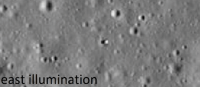
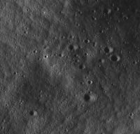
I saw your post on Surveyor 4 and dug up my old candidate files...
These are NAC images with illumination from West, Small incident, East , and Terminator (west) The Object is at 0.407N, -1.3493W It is probably a rock (sigh) I forget how much I blew them up, but they are all the same scale (3x?) anyway it's a nice little shadow casting object near the landing point... here is a GIF ...
-------------------- CLA CLL
|
|
|
|
|
|
|
Dec 8 2019, 11:37 AM
Post
#171
|
|
 Member Group: Members Posts: 547 Joined: 1-May 06 From: Scotland (Ecosse, Escocia) Member No.: 759 |
Going back a little, to the chat about LM impact images (and Post #384 by dvandorn about seismic detection)... they all came in at low incidence angles, quite unlike the SIVBs, hence the "smear" effect of tumbling debris in multiple dark streaks. Might this not produce a quite different seismic result than direct impacts from the virtually overhead descent of the SIVBs?
|
|
|
|
|
Feb 26 2020, 07:54 PM
Post
#172
|
||
|
Junior Member Group: Members Posts: 45 Joined: 18-July 05 Member No.: 439 |
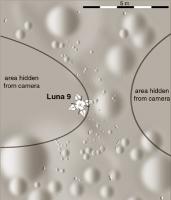
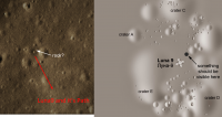
I’d like a possibility to be checked that I’ve found Luna 9 in LRO images.
Expected: Two objects of different size, namely E6 descent stage and the Luna 9 probe, landed in the vicinity of 7.13 N 64.37 W according to the TASS report of 06 Feb 1966. Found: Two bright objects of different brightness, with long shadows, 130 meters apart, at approximately 7.02 N 64.33 W. Positions: M132071202LE Larger one – Line=23370, Sample=1379 Smaller one – Line=23220, Sample=1645 See attached fragment (N at bottom, E at left) M114376090RE Larger one – Line=27910, Sample=3828 Smaller one – Line=28056, Sample=4073 M132071202LE Smaller one – Line=23660, Sample=275 Larger one – off picture but a black scar (?) seen at L=23706, S=66 Cross-posted in Russian at http://novosti-kosmonavtiki.ru/forum/forum...255/?PAGEN_1=91
Attached thumbnail(s)
|
|
|
|
|
|
|
Feb 27 2020, 01:02 AM
Post
#173
|
|
|
Solar System Cartographer Group: Members Posts: 10151 Joined: 5-April 05 From: Canada Member No.: 227 |
It's always interesting to see attempts to find one of the early Luna landers.
In this case, first, can you show with arrows which objects you think are the lander and the descent stage? There is one particularly large object but there are at least two smaller ones. (ADDED later: OK, I see you did that in the post on the Russian forum). Second, the coordinates given at the time were not very reliable, with an uncertainty of about 30 km (1 degree on the Moon). The landing should be in an area within about 30 km of the stated position, not necessarily right there. Third point - we don't have to rely only on looking for objects on the surface. Luna 9 took images which include a full 360 degree panorama showing about 200 degrees of the horizon (south, west and north of the lander). That horizon is flat, a point which I have argued for years to imply that the lander is not where the early reports said, near a range of 1000 m high hills, but must be far enough away that the hills are hidden below the local horizon. That local horizon could be a gentle ridge or degraded crater rim, so we can't just use the geometry of a featureless spherical moon to calculate a distance from the suggested point. Your coordinates are at the east end of the range of hills, and the western horizon from that location would not be flat. I personally prefer to look further north, maybe about 7.9 north, 64.2 west. But there is room for a lot of variation in those values. And since we have images, a rough map of the landing site can be made and the pattern of craters can be compared with the LRO images. Now what we need is an object representing the lander, an object representing the descent stage, AND several craters with sizes and positions matching the lander images. I will compare lander images and your LRO image in a later post. I do believe the search can be made successfully, but I don't think your identification is correct. I actually think Luna 13 will be easier to find than Luna 9 because the features seen in the distant landscape are clearer. For Luna 9 the distant landscape is down-sun and all washed out. Phil -------------------- ... because the Solar System ain't gonna map itself.
Also to be found posting similar content on https://mastodon.social/@PhilStooke Maps for download (free PD: https://upload.wikimedia.org/wikipedia/comm...Cartography.pdf NOTE: everything created by me which I post on UMSF is considered to be in the public domain (NOT CC, public domain) |
|
|
|
|
Feb 27 2020, 01:54 AM
Post
#174
|
||||
|
Solar System Cartographer Group: Members Posts: 10151 Joined: 5-April 05 From: Canada Member No.: 227 |
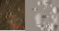
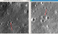
OK, here is a comparison of the suggested features with two versions of maps of the site.
1. The LRO image (rotated north-up) with two identified features, from the link in the previous post.
2. Shaded relief version (by me) of the original Soviet published map (from 'First Panoramas of the Lunar Surface').
3. A different interpretation of surface features, by me, derived from a reprojected panorama.
The differences between the two maps from Luna 9 images show how difficult it is to map the surface from a camera at such a low elevation above the surface. I don't see any obvious matches. Since we don't see the descent stage in the lander images, most likely it is east of the lander (or northeast or southeast), excluded from the tilted panorama. It might also lie west of the lander in an area in the foreground which was also not imaged. Phil -------------------- ... because the Solar System ain't gonna map itself.
Also to be found posting similar content on https://mastodon.social/@PhilStooke Maps for download (free PD: https://upload.wikimedia.org/wikipedia/comm...Cartography.pdf NOTE: everything created by me which I post on UMSF is considered to be in the public domain (NOT CC, public domain) |
|||
|
|
|
|||
|
Feb 27 2020, 12:06 PM
Post
#175
|
|
|
Junior Member Group: Members Posts: 45 Joined: 18-July 05 Member No.: 439 |
QUOTE (Phil Stooke @ Feb 27 2020, 04:54 AM)  The differences between the two maps from Luna 9 images show how difficult it is to map the surface from a camera at such a low elevation above the surface. I don't see any obvious matches. Thank you Phil. The Luna 9 maps show area some 15 meters in diameter; I'm not sure if these can be matched against LRO photos. A 1967 description of Luna 9 say it rests in the western slope of a depression of 14-15 meters in diameter, hence the tilt to the east. Such a depression should probably have been visible. Also, we should expect two fresh craters in the vicinity where two equipment sections crashed after separation at descent brake start. |
|
|
|
|
Oct 31 2020, 05:39 PM
Post
#176
|
|||
|
Junior Member Group: Members Posts: 38 Joined: 7-October 20 Member No.: 8895 |
May be this is the elusive Luna9 we are looking for?
Attached thumbnail(s)
|
||
|
|
|
||
|
Oct 31 2020, 06:06 PM
Post
#177
|
||
|
Junior Member Group: Members Posts: 38 Joined: 7-October 20 Member No.: 8895 |
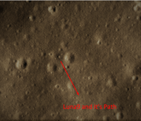
May be this is the elusive Luna9 we are looking for? There is small mark from NorthWest (25m from where it would have landed & rolled off?)
Landed near to a crater with diameter of 210-360m ( North of the landing spot there is a crater with length of 360m) There is a SouthWest small Hill feature at a distance of 7.5 km(Not sure whether it will be visible) LRO Images are from 0.44,0.52m resolutions To the Southern Side is the feature next to Plantia Descencus (The height of is 600m & I am not sure whether they would be visible from a distance of 7.5km due to Moon's curvature)
Attached thumbnail(s)
|
|
|
|
|
|
|
Oct 31 2020, 06:31 PM
Post
#178
|
||
|
Solar System Cartographer Group: Members Posts: 10151 Joined: 5-April 05 From: Canada Member No.: 227 |
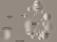
That's quite a good match to nearby features, better than what I usually see. I have highlighted one object which I think should be very apparent in the images but is missing. I feel that the feature in the area of my 'crater E' should be more prominent.
I don't mean to be eternally negative, but this is a very difficult problem to solve and only the most convincing evidence is good enough. It would be useful to know where this is. The issue of the mountains near the usually reported position has to be addressed. Shan had previously suggested a location in the hills south of the usual position but I didn't like the topography nearby which I felt would not allow a flat horizon to the south and west. Phil
-------------------- ... because the Solar System ain't gonna map itself.
Also to be found posting similar content on https://mastodon.social/@PhilStooke Maps for download (free PD: https://upload.wikimedia.org/wikipedia/comm...Cartography.pdf NOTE: everything created by me which I post on UMSF is considered to be in the public domain (NOT CC, public domain) |
|
|
|
|
|
|
Nov 1 2020, 05:13 AM
Post
#179
|
||||
|
Junior Member Group: Members Posts: 38 Joined: 7-October 20 Member No.: 8895 |
QUOTE (Phil Stooke @ Nov 1 2020, 12:01 AM) That's quite a good match to nearby features, better than what I usually see. I have highlighted one object which I think should be very apparent in the images but is missing. I feel that the feature in the area of my 'crater E' should be more prominent. I don't mean to be eternally negative, but this is a very difficult problem to solve and only the most convincing evidence is good enough. It would be useful to know where this is. The issue of the mountains near the usually reported position has to be addressed. Shan had previously suggested a location in the hills south of the usual position but I didn't like the topography nearby which I felt would not allow a flat horizon to the south and west. Phil
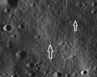
Sent you the co-ordinates in a message with links Yes there is something visible as you said see the below images and One is the normalized without any zoom & another one is a zoomed in picture.. And also attached a Gif of the same area under different lighting conditions & the object lighting remains almost the same with darkness underneath due to soil disturbance? There are some debris to the South East side but I don't see any craters ( The images I have attached here are 0.44m resolution)
Attached thumbnail(s)
|
|||
|
|
|
|||
|
Nov 4 2020, 01:56 AM
Post
#180
|
||
|
Junior Member Group: Members Posts: 38 Joined: 7-October 20 Member No.: 8895 |
QUOTE (Shan @ Nov 1 2020, 10:43 AM) Sent you the co-ordinates in a message with links Yes there is something visible as you said see the below images and One is the normalized without any zoom & another one is a zoomed in picture.. And also attached a Gif of the same area under different lighting conditions & the object lighting remains almost the same with darkness underneath due to soil disturbance? There are some debris to the South East side but I don't see any craters ( The images I have attached here are 0.44m resolution) The only thing I doubt is all the reports mention it should be on the western slope of a small depression so the tilt to east Lat:7.506 Lon:295.508 https://quickmap.lroc.asu.edu/query?extent=...teQDeAvgLqlFmlA Is the Western slope means the slope is from east to west? and the place where I am exactly showing is 2m below the surface
Attached thumbnail(s)
|
|
|
|
|
|
|

|
Lo-Fi Version | Time is now: 25th April 2024 - 11:50 AM |
|
RULES AND GUIDELINES Please read the Forum Rules and Guidelines before posting. IMAGE COPYRIGHT |
OPINIONS AND MODERATION Opinions expressed on UnmannedSpaceflight.com are those of the individual posters and do not necessarily reflect the opinions of UnmannedSpaceflight.com or The Planetary Society. The all-volunteer UnmannedSpaceflight.com moderation team is wholly independent of The Planetary Society. The Planetary Society has no influence over decisions made by the UnmannedSpaceflight.com moderators. |
SUPPORT THE FORUM Unmannedspaceflight.com is funded by the Planetary Society. Please consider supporting our work and many other projects by donating to the Society or becoming a member. |
|