Printable Version of Topic
Click here to view this topic in its original format
Unmanned Spaceflight.com _ Mars _ Searching for updated Mars albedo maps
Posted by: Antdoghalo Jul 20 2023, 06:28 PM
I have been looking for Mars albedo maps and it is a pain to find them at decent resolution and they are all really outdated.
The easy to find global one is a low resolution one from the MGS TES from before the 2001 duststorm: https://astrogeology.usgs.gov/search/map/Mars/GlobalSurveyor/TES/Mars_MGS_TES_Albedo_mosaic_global_7410m
There exists a higher resolution albedo dataset from after this duststorm but its in an odd binary format unable to easily be transformed into an image: https://sharad.psi.edu/inertia/2007/albedo.html
Then there is the Mars Express one but this one is sadly very hastily put together with holes and seams all over it from the different orbital swaths, dated ten years ago as ESA has seemingly abandoned the mapping of Mars Express imagery a while back. https://www.cosmos.esa.int/web/psa/mars-maps
Has anyone had any better luck locating more up to date albedo maps of the red planet? I am specifically looking for one from after the "Oppy killer" dust storm in 2018.
Posted by: mcaplinger Jul 20 2023, 09:30 PM
https://astrogeology.usgs.gov/search/map/Mars/MarsReconnaissanceOrbiter/MARCI/MARS-MRO-MARCI-Mars-Daily-Global-Maps are MARCI global maps for the first two Mars years of MRO.
The raw MARCI images are in PDS but I'll admit processing them is probably painful. I got out of that game after MGS.
Posted by: Antdoghalo Jul 21 2023, 06:20 AM

The raw MARCI images are in PDS but I'll admit processing them is probably painful. I got out of that game after MGS.
Yeah I previously was able to make a cloud map from that database after combining like 9 maps from band 1 at different seasons. Unfortunately with albedo it doesn't work as easily. Hellas keeps appearing as bright as an ice cap in all bands.
Posted by: Antdoghalo Jul 21 2023, 06:26 AM
Someone was able to get the 2007 binary map converted for me and its only in somewhat better shape than the ESA map given it is at least complete though has many bad passes here and there.
Posted by: kymani76 Jul 21 2023, 06:54 AM
There is also Mars Express Omega NIR albedo map available https://archives.esac.esa.int/psa/ftp/MARS-EXPRESS/OMEGA/MEX-M-OMEGA-5-DDR-GLOBAL-MAPS-V1.0/DATA/ALBEDO/.
It hasn't been updated since 2013 and there are coverage gaps, but it has higher resolution than MGS maps.
edit: Sorry I was too hasty, the link was already posted. Mods can delete this post. Thank you.
Posted by: Antdoghalo Jul 21 2023, 06:59 AM
That is the aforementioned Mars Express map.
Posted by: JohnVV Jul 21 2023, 02:42 PM
on the AlbMY26map map i can run ISIS3's "dstrip" program on it and remove some but not all of the stripping
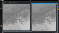
|
on the right is the destriped map
Posted by: kymani76 Jul 23 2023, 09:25 PM
|
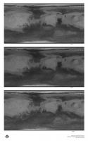
I couldn't resist playing with this dataset and managed to extract the maps for three Mars years using IDL.
If anyone needs original images, drop me a note. There are both 8 and 32 bit versions available.
Posted by: JohnVV Jul 24 2023, 02:34 PM
i used isis3's dstrip tool and removed some of the stripping on the 26 map
here is a link on my g-drive
https://drive.google.com/file/d/1F3Jo_yKJDlIQn-D8VmWI90H9Oc5J2qQ5/view?usp=sharing
Posted by: Bill Harris Nov 22 2023, 11:19 PM
Current albedo maps for the purpose of terrestrial visual and photo observations?
Those would be useful.
--Bill
Powered by Invision Power Board (http://www.invisionboard.com)
© Invision Power Services (http://www.invisionpower.com)