

Whole Earth images, Does any satellite provide regularly updated ones? |

  |
Whole Earth images, Does any satellite provide regularly updated ones? |
 Dec 21 2009, 12:32 AM Dec 21 2009, 12:32 AM
Post
#121
|
|
 Senior Member  Group: Members Posts: 1627 Joined: 5-March 05 From: Boulder, CO Member No.: 184 |
QUOTE (elakdawalla @ Dec 20 2009, 11:16 PM)  Does anybody have any brilliant ideas on how to find out what was happening in terms of weather on December 8, 1992? The animation appears to cover the Pacific Ocean, Australia, and Asia, finishing with eastern Africa on the terminator. Emily - we might be able to correlate with these views for the 16th. I can key on the storm over Australia in both images. http://www.ncdc.noaa.gov/gibbs/html/GMS-4/IR/1992-12-16-21 http://www.ncdc.noaa.gov/gibbs/html/GMS-4/VS/1992-12-16-21 Other times and satellites can be selected here: http://www.ncdc.noaa.gov/gibbs/availability/1992-12-16 It's fun though difficult to try and see cloud motions in the Galileo animations. As a side note I'm considering trying to make simulated real-time global visible satellite images that should give much the appearance of the Galileo animations using Science On A Sphere. These would have the terminator and night-time lights added for some sort of realism. -------------------- Steve [ my home page and planetary maps page ]
|
 |
 
|
|
Dec 21 2009, 01:02 AM
Post
#122
|
|
|
Junior Member Group: Members Posts: 53 Joined: 15-July 09 Member No.: 4867 |
I just wonder which is the first image of the "full" disk of Earth ? Should it be an image taken by Luna 1 or Pioneer 4 ?
It's hard to find full data of those spacecrafts to check that, but maybe you may know... 
|
|
|
|
|
Dec 21 2009, 01:16 AM
Post
#123
|
|
|
Merciless Robot Group: Admin Posts: 8783 Joined: 8-December 05 From: Los Angeles Member No.: 602 |
Good question. Definitely not any of the early Lunas, and IIRC none of the Pioneers before P10 even had cameras. I'd actually bet that it was one of the Lunar Orbiters (LO3?)
EDIT: No, wait a minute: Might have been TIROS 1. Will check it out. -------------------- A few will take this knowledge and use this power of a dream realized as a force for change, an impetus for further discovery to make less ancient dreams real.
|
|
|
|
|
Dec 21 2009, 01:20 AM
Post
#124
|
|
|
Junior Member Group: Members Posts: 53 Joined: 15-July 09 Member No.: 4867 |
Apparently, it's before Lunar Orbiter 1:
http://nssdc.gsfc.nasa.gov/imgcat/html/obj...1_h102_123.html I quote: "This is the first good image of the Earth taken from the vicinity of the Moon, 380,000 km away." For me, "good" means that there were bad pictures earlier. |
|
|
|
|
Dec 21 2009, 01:27 AM
Post
#125
|
|
|
Junior Member Group: Members Posts: 53 Joined: 15-July 09 Member No.: 4867 |
And this can not be TIROS 1, as its apogee is only 756km. I even think that the first geostationnary satellites may not be the first to take that picture, as very elliptical orbits (reached before GEO) can allow observing the entire earth.
|
|
|
|
|
Dec 21 2009, 04:53 AM
Post
#126
|
|
|
Member Group: Members Posts: 194 Joined: 8-February 04 Member No.: 10 |
which is the first image of the "full" disk of Earth ?
The first crude B&W television image of the Earth as a disk was made by a Soviet weather satellite on May 30, 1966. The first crude color image of Earth as a disk was made by the Department Of Defense Gravity Experiment satellite (DODGE) operating between July and November 1967 http://www.donaldedavis.com/2003NEW/NEWSTUFF/DDEARTH.html |
|
|
|
|
Dec 21 2009, 02:47 PM
Post
#127
|
|
|
Junior Member Group: Members Posts: 53 Joined: 15-July 09 Member No.: 4867 |
Great, thanks for all those information !
But do you have any idea of the identity of that "Soviet weather satellite" ? Because I have controversal sources. According that page, Kosmoss 122 is the first soviet weather satellite and has been launched... the 25th June 1966 (after your image snap date). But according to the ESA page here, the first soviet weather satellite is Kosmos 144, launched in Feb. 1967.  Other sources have more fuzzy descriptions of Kosmos 122, such as here, describing it as the first soviet weather satellite of the Meteor class (as a prototype). |
|
|
|
|
Dec 21 2009, 04:02 PM
Post
#128
|
|
 Senior Member Group: Members Posts: 3648 Joined: 1-October 05 From: Croatia Member No.: 523 |
QUOTE (scalbers @ Dec 21 2009, 01:32 AM) Emily - we might be able to correlate with these views for the 16th. I can key on the storm over Australia in both images. Wow, I didn't realize you could go back and look at the weather this far back. Thanks, Steve. Nice to see the weather matching up between the two sources.  A fun fact - Galileo was 6.15 million km from Earth at the start of the sequence and that increased to 6.58 million km at the end. At that distance, the Moon is just 6% closer in so the relative sizes of the two bodies are preserved fairly well. Also, during those 13.5 hours Galileo actually covered more than one lunar distance. Sure doesn't look so in telescopic imagery, does it? EDIT: Using Steve's link above, these two observations were near-simultaneous (to the minute), they indeed match the clouds right down to the terminator line. 
-------------------- |
|
|
|
|
Dec 22 2009, 02:38 AM
Post
#129
|
|
|
Member Group: Members Posts: 166 Joined: 20-September 05 From: North Texas Member No.: 503 |
QUOTE (elakdawalla @ Dec 21 2009, 12:16 AM) Does anybody have any brilliant ideas on how to find out what was happening in terms of weather on December 8, 1992? The animation appears to cover the Pacific Ocean, Australia, and Asia, finishing with eastern Africa on the terminator. I don't have any "brilliant ideas". But here are a couple of comments and links that might prove useful: The first link shows winds at 500, 700, and 850 mb, along with the surface analysis for 8 Dec 1992. http://www.meteo.psu.edu/~gadomski/NARR/1992/us1208.php Unfortunately, these maps only cover the continental US. But notice the trough on the west coast. That accounts for the clouds visible in western North America. And interestingly, resulted in storms that produced 5 inches of rain in Los Angeles, and over two feet of snow in the Sierras. This PDF link to the Weekly Weather and Crop Bulletin for the week of 6-12 December 1992 shows the resulting weather (primarily focused on precipitation) in the US and elsewhere around the world. But it is weekly summaries, rather than detailed weather for 8 Dec 1992. http://usda.mannlib.cornell.edu/usda/waob/...-12-15-1992.pdf Probably not of much use. But Emily's question piqued my interest. And yes, Gordan, the animation is fantastic! Thanks again for your great work here. |
|
|
|
|
Jan 2 2010, 03:51 PM
Post
#130
|
|
|
Senior Member Group: Members Posts: 3648 Joined: 1-October 05 From: Croatia Member No.: 523 |
Here's another Earth animation, this one a Deep Impact a.k.a. EPOXI HRI sequence taken March 18/19 2008 from cca. 27 million km. The images are blurry, I deconvolved them but that introduced ringing artifacts. A special thanks to Sean Walker for pointing me to MaxIm DL 5 I used for deconvolution. I used the supplied PSF for the imager on the data volumes. Here's a comparison of a source image and deconvolved one (click):
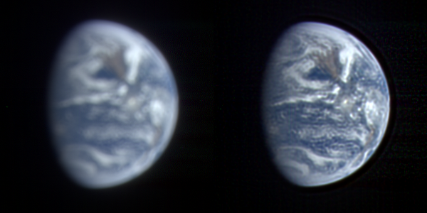 The sequence consists of 97 frames taken every 15 minutes and spanning one whole day. For some reason a couple of frames wouldn't converge in deconvolution, these are noticeable as blurred frames. Also, the calibrated data apparently had a line of noisy/hot pixels running near the center of detector, deconvolution made it worse and Earth's terminator is artifacted in some frames, notably at the beginning. The animated gif (5 megabytes) can be found here. The first and last frames are exactly 1 day apart, here's a flicker gif showing cloud evolution in the Pacific. Corresponding satellite imagery (GOES 11): March 18 and March 19. Even though there are ringing artifacts due to deconvolution, more of the smaller cloud details than I anticipated are actually real, as illustrated here. While the Galileo animation was taken near winter solstice, this was taken very close to spring equinox and illustrates a difference in illumination - both sequences have the sun to the right, but Earth spins differently. EDIT: fixed the few exceedingly blurry frames in the animation. -------------------- |
|
|
|
|
Jan 2 2010, 04:01 PM
Post
#131
|
|
|
Senior Member Group: Members Posts: 1627 Joined: 5-March 05 From: Boulder, CO Member No.: 184 |
Gordan, pretty impressive results for the deconvolution as I could see some of the cloud features in your comparison. I suppose having the PSF helped, as well as maybe high bit resolution in the dataset. Nice to have the animation span an entire day as I can see all the continents coming into view.
-------------------- Steve [ my home page and planetary maps page ]
|
|
|
|
|
Jan 2 2010, 04:06 PM
Post
#132
|
|
|
Founder Group: Chairman Posts: 14431 Joined: 8-February 04 Member No.: 1 |
Make me wonder just what the genius of people like Damian Peach et.al. could do if we all lived on Mars, and Earth was just an astronomical target through 12" telescopes. I think it would be quite a lot like that image sequence. Awesome work!
|
|
|
|
|
Jan 2 2010, 04:08 PM
Post
#133
|
|
|
Senior Member Group: Members Posts: 3648 Joined: 1-October 05 From: Croatia Member No.: 523 |
Steve, yes, this observation is at a significantly larger pixel scale than the Moon transit sequence from May 2008. Every bit helps.
Doug, without a doubt, to anyone living on Mars Earth would be competing with Jupiter as the most photogenic object out there! -------------------- |
|
|
|
|
Jan 20 2010, 04:52 AM
Post
#134
|
|
 Junior Member Group: Members Posts: 21 Joined: 21-September 07 From: Seattle Member No.: 3912 |
QUOTE (Lightning @ Dec 20 2009, 05:20 PM) Apparently, it's before Lunar Orbiter 1: http://nssdc.gsfc.nasa.gov/imgcat/html/obj...1_h102_123.html I quote: "This is the first good image of the Earth taken from the vicinity of the Moon, 380,000 km away." For me, "good" means that there were bad pictures earlier. This image has been cleaned up by LOIRP, and can be viewed here. |
|
|
|
|
Jan 20 2010, 11:25 AM
Post
#135
|
|
 Interplanetary Dumpster Diver Group: Admin Posts: 4404 Joined: 17-February 04 From: Powell, TN Member No.: 33 |
I don't think that is from LOIRP, but it is a nice image.
-------------------- |
|
|
|
|

|
Lo-Fi Version | Time is now: 23rd April 2024 - 08:31 AM |
|
RULES AND GUIDELINES Please read the Forum Rules and Guidelines before posting. IMAGE COPYRIGHT |
OPINIONS AND MODERATION Opinions expressed on UnmannedSpaceflight.com are those of the individual posters and do not necessarily reflect the opinions of UnmannedSpaceflight.com or The Planetary Society. The all-volunteer UnmannedSpaceflight.com moderation team is wholly independent of The Planetary Society. The Planetary Society has no influence over decisions made by the UnmannedSpaceflight.com moderators. |
SUPPORT THE FORUM Unmannedspaceflight.com is funded by the Planetary Society. Please consider supporting our work and many other projects by donating to the Society or becoming a member. |
|


