Printable Version of Topic
Click here to view this topic in its original format
Unmanned Spaceflight.com _ Mars _ Absolute lowest point on Mars
Posted by: BuckGalaxy Nov 24 2016, 12:50 AM
This small crater within the Hellas Crater is the lowest point on Mars but I can't seem to find any detailed information on it. Not even a name. Anyone have any info on its name, size, how deep it is, atmospheric pressure, temperature ranges, etc?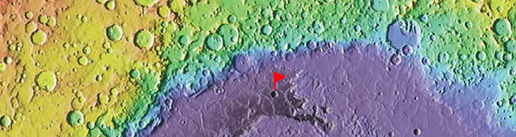
Sorry if this info is already somewhere else on this site but I can't locate it if it is.
Posted by: PaulH51 Nov 24 2016, 01:17 AM

I found this post from 2006 http://www.unmannedspaceflight.com/index.php?s=&showtopic=3280&view=findpost&p=70930 : The external links no longer work, but there are some details you were looking for and references that you may be able to Google.
Posted by: Habukaz Nov 24 2016, 12:06 PM
The best source for official place names in the Solar System that I know of, is the http://planetarynames.wr.usgs.gov/ (use the Nomenclature menu).
From map http://planetarynames.wr.usgs.gov/images/mc28_2014.pdf from http://planetarynames.wr.usgs.gov/Page/mars1to5mTHEMIS, it seems that the crater you have highlighted is http://planetarynames.wr.usgs.gov/Feature/15314?__fsk=-1113380440, located on the plains of Peneus Palus. Its name was accepted in April last year.
It has been imaged by both http://www.uahirise.org/ESP_026795_1470 and http://viewer.mars.asu.edu/planetview/inst/ctx/D06_029472_1470_XN_33S297W#P=D06_029472_1470_XN_33S297W&T=2 (several times by the latter), and is the focus of many http://www.uahirise.org/hiwish/view/41704 suggestions.
(whether the crater in question is the actual lowest point on Mars, I have no idea)
Posted by: JohnVV Nov 26 2016, 04:26 AM
the mola data is rather sparse . although there is a 64 ppd map it's usefulness is really only about 16ppd for the most part
but that area looks good
the min MOLA value is -8193 Meters for this
http://imgbox.com/6LA9wcK1
Posted by: volcanopele Nov 27 2016, 04:16 PM
For context, Badwater Basin contains the lowest point in North America.
Posted by: scalbers Nov 27 2016, 06:44 PM
Should be about 15mb of max air pressure and water boiling point of 13C.
http://www.unmannedspaceflight.com/index.php?s=&showtopic=7489&view=findpost&p=192830
Posted by: BuckGalaxy Nov 28 2016, 06:35 PM
Thank you for the responses!
Posted by: JRehling Nov 28 2016, 08:14 PM
The latitude means that the Sun comes within 8° of zenith. The cosine of 8° is 0.99, a negligible difference from 1.0, so this may indeed be the place on Mars with the most time per year with conditions that allow liquid water, though that would be a complicated thing to nail down. It's certainly a decent candidate for that. The polygonal terrain indicates that drying of "wet" regolith has occurred at some point, but that is true of a great many locations, including the Phoenix and Viking 2 landing sites.
Posted by: TheAnt Nov 30 2016, 11:23 AM
13 degrees? I still feel that's a bit chilly for a swim.

Serious: Hellas have indeed been mentioned as the best candidate for potential liquid water, even if it might only be in the form of a bit of humidity today.
Now that assumption was most likely based on potential airpressure alone, now BuckGalaxy migh thave pinpointed the very spot where there might be a fraction more of that.
This polygonal terrain JRehling mention is indeed a sign of that the area have dried up at some point.
There's a hypothesis that Mars undergo warmer and more benign periods from time to time, if water have been flowing here comparatively more recently - 10-100 kiloyears or so, it must have been so smallscale we cannot see it in the image resolution we now have for the area.
Posted by: BuckGalaxy Nov 30 2016, 05:44 PM
Serious: Hellas have indeed been mentioned as the best candidate for potential liquid water, even if it might only be in the form of a bit of humidity today.
Now that assumption was most likely based on potential airpressure alone, now BuckGalaxy migh thave pinpointed the very spot where there might be a fraction more of that.
This polygonal terrain JRehling mention is indeed a sign of that the area have dried up at some point.
There's a hypothesis that Mars undergo warmer and more benign periods from time to time, if water have been flowing here comparatively more recently - 10-100 kiloyears or so, it must have been so smallscale we cannot see it in the image resolution we now have for the area.
I would love to take credit for identifying the lowest elevation on Mars! LOL However, credit to where it's due, I got the op image from here: http://geology.com/articles/highest-point-on-mars.shtml
No hard info on the diameter of the crater, but eyeballing it, maybe 20km?
Posted by: BuckGalaxy Dec 1 2016, 08:55 PM
I was looking at Google Mars and I was able to compare the relative size of Badwater Crater to Endeavor Crater where Opportunity is exploring. Endeavor is 22km in diameter and Badwater looks like it's close to twice that size.
Then I found this: https://planetarynames.wr.usgs.gov/Feature/15314
Badwater is 33.14 km in diameter according to this link. The zoomable map at this link is worth a look.
Powered by Invision Power Board (http://www.invisionboard.com)
© Invision Power Services (http://www.invisionpower.com)