Exploring Mt Sharp - The Dunes - Part 2: Naukluft Plateau, Sites 53-54, Sols 1274-1352, March 7-May 27 2016 |

  |
Exploring Mt Sharp - The Dunes - Part 2: Naukluft Plateau, Sites 53-54, Sols 1274-1352, March 7-May 27 2016 |
 Mar 9 2016, 08:43 PM Mar 9 2016, 08:43 PM
Post
#16
|
||
|
Senior Member  Group: Members Posts: 2869 Joined: 22-April 05 From: Ridderkerk, Netherlands Member No.: 353 |
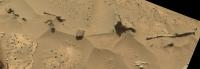
The Navcam L view on Sol 1276.
Jan van Driel
|
|
 |
 
|
|
|
Mar 9 2016, 09:30 PM
Post
#17
|
||
|
Solar System Cartographer Group: Members Posts: 10226 Joined: 5-April 05 From: Canada Member No.: 227 |
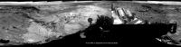
Thanks, Jan - here it is as a circular projection.
Phil
-------------------- ... because the Solar System ain't gonna map itself.
Also to be found posting similar content on https://mastodon.social/@PhilStooke Maps for download (free PDF: https://upload.wikimedia.org/wikipedia/comm...Cartography.pdf NOTE: everything created by me which I post on UMSF is considered to be in the public domain (NOT CC, public domain) |
|
|
|
|
|
|
Mar 9 2016, 09:43 PM
Post
#18
|
||
|
Member Group: Members Posts: 306 Joined: 4-October 14 Member No.: 7273 |
QUOTE (Julius @ Mar 9 2016, 06:17 AM)  Do I see blueberries in the foreground? I don't think they're blueberries (iron oxide concretions) per se, but more nodular concretions of whatever cement is holding the mudstone together. I think on closer inspection that the Murray formation here will look more like this rock observed back on Sol 1256.
|
|
|
|
|
|
|
Mar 9 2016, 10:15 PM
Post
#19
|
||
|
Senior Member Group: Members Posts: 1055 Joined: 17-February 09 Member No.: 4605 |
I think that Julias was referring to this scattering of fragments.
Attached thumbnail(s)
|
|
|
|
|
|
|
Mar 10 2016, 12:04 AM
Post
#20
|
|
|
Member Group: Members Posts: 923 Joined: 10-November 15 Member No.: 7837 |
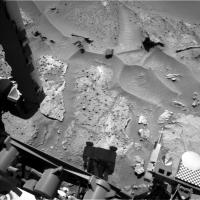
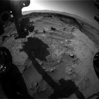
Here are some postcards from Sol 1276...
3D crosseye  Sol 1276_Navcam stereo postcard_low_crosseye  Sol 1276_Navcam stereo postcard_crosseye002  Sol 1276_Navcam stereo postcard_crosseye001 3DTV/VR  Sol 1276_Navcam stereo postcard_wide_3DTV  Sol 1276_Navcam stereo postcard_test_3DTV  Sol 1276_Navcam stereo postcard_low_3DTV  Sol 1276_Navcam stereo postcard_3DTV ...some lovely depth going on in these if you can forgive minor stitching and framing anomalies. I'm projecting these onto my study wall using a 3D projector with active 3D shutter glasses and its quite the view. -------------------- |
|
|
|
|
Mar 10 2016, 08:29 AM
Post
#21
|
||
 Senior Member Group: Members Posts: 2431 Joined: 30-January 13 From: Penang, Malaysia. Member No.: 6853 |
1275 L-MastCam 5-Frame mosaic, assembled in MS ICE, without any additional processing. I foresee some interesting driving conditions atop this plateau

Edit Processed version: 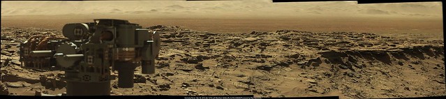 Flickr : 1024 x 227 Flickr : 5688x1263 |
|
|
|
|
|
|
Mar 10 2016, 08:28 PM
Post
#22
|
|
|
Member Group: Members Posts: 866 Joined: 15-March 05 From: Santa Cruz, CA Member No.: 196 |
|
|
|
|
|
Mar 10 2016, 09:43 PM
Post
#23
|
|
|
Senior Member Group: Members Posts: 2431 Joined: 30-January 13 From: Penang, Malaysia. Member No.: 6853 |
QUOTE (atomoid @ Mar 11 2016, 04:28 AM) ICE stitch of six frames..... And some nice thumbs just down-linked of a set of focus merged MAHLI's featuring a variety of liberated pebbles, but sadly not the wreck of the Hesperus    Click thumbnails to open the full size frames
|
|
|
|
|
Mar 11 2016, 02:37 AM
Post
#24
|
|
|
Junior Member Group: Members Posts: 58 Joined: 9-April 15 Member No.: 7433 |
Who let the Snails out of Aquarium?
Very interesting stuff. |
|
|
|
|
Mar 11 2016, 03:19 AM
Post
#25
|
|||
|
Senior Member Group: Members Posts: 2431 Joined: 30-January 13 From: Penang, Malaysia. Member No.: 6853 |
2 USGS Mission Updates from Ryan Anderson:
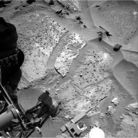
Sol 1277: Nodules! Our drive yesterday was a success, putting us right on the contact between the Murray and Stimson units, and in reach of some very interesting nodules. The plan today is mostly focused on studying those nodules. ChemCam has an observation of a nodule and neighboring bedrock at the target Vogelfederberg followed by a depth profile on one of the nodules named Verbrandeberg. For the depth profile, we will only analyze two locations on the target, but we will shoot each location with the laser 150 times instead of the normal 30 shots. These extra shots allow us to measure changes in the chemistry in the outer surface of the target. After the depth profile, ChemCam will analyze two other nodule and bedrock locations named Maieberg and Mikberg. Mastcam will take documentation images of all of these targets. Later in the day, we will use MAHLI to take some images of a nodule named Sperrgebiet, plus a broader mosaic of the nodular texture. APXS will then measure the composition of Sperrgebiet and the neighboring bedrock. Tomorrow the plan is to back out of our current location and then drive up onto Naukluft plateau! Sol 1278: Nodules: Take 2 Our APXS observation of the nodules in yesterdays plan didnt go exactly as planned: it was slightly misaligned with the nodule we were trying to analyze, so the measurement was mostly of the neighboring bedrock. That meant planning today started with a discussion of whether the chemistry from ChemCam was sufficient, or if we should spend another day and nail the APXS measurement as well. In the end we decided to try again and make sure we get all the data we want about the nodules before moving on. The Sol 1278 plan starts with ChemCam analyses and Mastcam images of the targets Tsarabis, Lofdal, Kunene, and Nababis. Mastcam also has two mosaics to capture the contact between the Murray and Stimson formations and the transition from knobby nodule-rich bedrock to less nodule-rich bedrock. After that, MAHLI will collect images of the nodule targets Sperrgebiet, Maieberg, and Konigstein and APXS will try again to do an overnight measurement of the composition of Sperrgebiet. Since this is the second try, the rover planners have yesterdays data to work with and should be able to place the APXS more accurately. If all goes well, we should be able to wrap up at this location and drive away in the weekend plan! 1277
|
||
|
|
|
||
|
Mar 11 2016, 04:40 AM
Post
#26
|
|
 Administrator Group: Admin Posts: 5172 Joined: 4-August 05 From: Pasadena, CA, USA, Earth Member No.: 454 |
I talked to Ashwin today but probably won't write it up until next week, so a tidbit for now: he told me that they spotted these nodules a couple of days ago and thought they were cool enough to detour for, so they are at a "dead end" in terms of the drive, will focus on them for the weekend, and then plan to backtrack a bit next week before continuing uphill and onto the plateau. It's endlessly fascinating how varied the appearance of the Murray-Stimson contact is from place to place.
-------------------- My website - My Patreon - @elakdawalla on Twitter - Please support unmannedspaceflight.com by donating here.
|
|
|
|
|
Mar 12 2016, 06:41 AM
Post
#27
|
|
 Member Group: Members Posts: 146 Joined: 22-November 14 From: Bormida (SV) - Italy Member No.: 7348 |
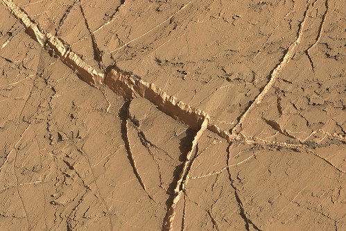
Panorama sol 1276
 and an anaglyph of the white fracture 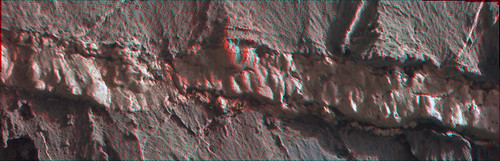
-------------------- |
|
|
|
|
Mar 12 2016, 09:02 AM
Post
#28
|
||
|
Senior Member Group: Members Posts: 2431 Joined: 30-January 13 From: Penang, Malaysia. Member No.: 6853 |
Curiosity Mission Update from Ryan Anderson (March 11th) Sols 1279-1281: Climbing up onto Naukluft Plateau
QUOTE Its time to wrap up our investigation of the interesting nodules at the contact between the Murray and Stimson formations and resume driving! The weekend starts off focused mostly on contact science. On Sol 1279, APXS will analyze two neighboring locations on a group of nodules collectively called Khomas, and then on Sol 1280 APXS will analyze a third location on Khomas. MAHLI will collect supporting images, and will also take some pictures of the targets Etendeka and Maieberg. In the morning on Sol 1280, the rover will make some atmospheric measurements using Navcam, Mastcam, and ChemCam, followed by a 20-spot ChemCam analysis of the target Marienfluss, right across the Murray-Stimson contact. Mastcam will take a support image of Marienfluss, plus a small mosaic of a target called Kerpfenkliff. Then on Sol 1281, we will get moving again with a ~70 meter drive that should take us up onto the Naukluft plateau. During the drive, MARDI will collect some images of the terrain underneath the rover. After the drive we have post-drive imaging, and I added a request for some Navcam images of Mt. Sharp to help target potential long distance ChemCam RMI images next week.
|
|
|
|
|
|
|
Mar 13 2016, 12:49 PM
Post
#29
|
|
|
Senior Member Group: Members Posts: 2431 Joined: 30-January 13 From: Penang, Malaysia. Member No.: 6853 |
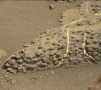
Sol 1274 R-MastCam mosaic. Roughly assembled in MS ICE / processed-cropped. Highlighting the exposed mineral filled veins in the Murray unit sandstone bedrock.
 Flickr 1024 x 683 Flickr 2283x1522 |
|
|
|
|
Mar 14 2016, 03:34 AM
Post
#30
|
||
|
Senior Member Group: Members Posts: 2431 Joined: 30-January 13 From: Penang, Malaysia. Member No.: 6853 |
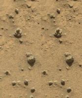
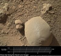
Sol 1277 MAHLI: Possibly a float object at the location containing the sandstone nodules? Scale bar thanks to Gerald's MAHLI Ruler.
Raw MALI images 1277 |
|
|
|
|
|
|

|
Lo-Fi Version | Time is now: 21st September 2024 - 01:03 AM |
|
RULES AND GUIDELINES Please read the Forum Rules and Guidelines before posting. IMAGE COPYRIGHT |
OPINIONS AND MODERATION Opinions expressed on UnmannedSpaceflight.com are those of the individual posters and do not necessarily reflect the opinions of UnmannedSpaceflight.com or The Planetary Society. The all-volunteer UnmannedSpaceflight.com moderation team is wholly independent of The Planetary Society. The Planetary Society has no influence over decisions made by the UnmannedSpaceflight.com moderators. |
SUPPORT THE FORUM Unmannedspaceflight.com is funded by the Planetary Society. Please consider supporting our work and many other projects by donating to the Society or becoming a member. |
|


 ) ..also, a parellel stereo of the nodular