Perseverance - Early Drives, Sols 14-72 |

  |
Perseverance - Early Drives, Sols 14-72 |
 Mar 6 2021, 03:30 PM Mar 6 2021, 03:30 PM
Post
#16
|
|
|
Senior Member  Group: Members Posts: 2082 Joined: 13-February 10 From: Ontario Member No.: 5221 |
In the telecon yesterday they made clear that they will be staying away from any EDL hardware for contamination reasons.
We'd all like to see it, but Oppy's encounter was a confluence of circumstances. All the hardware was visible as soon as they left Eagle crater, the heat shield was right on the traverse path from Endurance crater, and there were far fewer concerns about close proximity negatively affecting the science mission. Look on the bright size; Mastcam-Z allows imaging at a distance with much more detail (if local topography allows), so no need to get super-close. |
 |
 
|
|
Mar 6 2021, 03:36 PM
Post
#17
|
||
 Senior Member Group: Members Posts: 1083 Joined: 19-February 05 From: Close to Meudon Observatory in France Member No.: 172 |
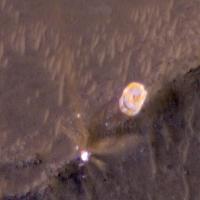
QUOTE (Steve G @ Mar 6 2021, 04:15 PM)  You'd think the Blue path would be more interesting with a large crater and the heat shield not far off the path that I'm certain the engineers would like to have a peek at. Yes for sure  But also, like many, I would like a visit to see (even from a distance) the colorful parachute and its backshell. This would be a great opportunity for Education & Public Outreach and would offer the public great memorable pictures to see. And we will not have other opportunities to take such impressive pictures for decades to come
|
|
|
|
|
|
|
Mar 6 2021, 03:43 PM
Post
#18
|
|
|
Forum Contributor Group: Members Posts: 1372 Joined: 8-February 04 From: North East Florida, USA. Member No.: 11 |
QUOTE (Marvin @ Mar 6 2021, 03:27 PM) But perhaps the most visible change is in the grousers. They are ten percent taller and run across the width of the wheel in a near straight line. Its got a slight curvature to it to help give some strength to it, says JPL engineer Patrick DeGrosse. That Percy wheel looks pretty good for doing 60Km. |
|
|
|
|
Mar 6 2021, 04:43 PM
Post
#19
|
|
|
Member Group: Members Posts: 180 Joined: 31-January 05 From: Brittany (France) Member No.: 164 |
It seems Perseverance is now roughly 30 metres NNE of Octavia E. Butler site : the blue path is maybe already the chosen path.
-------------------- Erwann |
|
|
|
|
Mar 6 2021, 06:00 PM
Post
#20
|
||
|
Member Group: Members Posts: 180 Joined: 31-January 05 From: Brittany (France) Member No.: 164 |
I think here is approximately the location of Perseverance after sol 15 drive, marked in a sol 11 left mastcam Z image.
-------------------- Erwann |
|
|
|
|
|
|
Mar 6 2021, 06:12 PM
Post
#21
|
||
 Member Group: Members Posts: 809 Joined: 3-June 04 From: Brittany, France Member No.: 79 |
Picture taken by Navcam Right on sol 15 showing tracks left by tosol drive.
-------------------- |
|
|
|
|
|
|
Mar 6 2021, 06:34 PM
Post
#22
|
|
 Senior Member Group: Members Posts: 1887 Joined: 20-November 04 From: Iowa Member No.: 110 |
Why are they avoiding the area directly to the west?
|
|
|
|
|
Mar 6 2021, 06:41 PM
Post
#23
|
|
|
Member Group: Members Posts: 180 Joined: 31-January 05 From: Brittany (France) Member No.: 164 |
Alan, maybe they want to avoid sand dunes traverse ?
-------------------- Erwann |
|
|
|
|
Mar 6 2021, 06:48 PM
Post
#24
|
|
|
Senior Member Group: Members Posts: 2082 Joined: 13-February 10 From: Ontario Member No.: 5221 |
From the MRO images, it seems like there is room between the ripples to maneuver (it's not a solid field like what Curiosity had to go around to reach Mount Sharp), but presumably the team does not want to take even a small risk at this stage of the mission.
|
|
|
|
|
Mar 6 2021, 06:59 PM
Post
#25
|
||
|
Member Group: Members Posts: 102 Joined: 12-August 12 Member No.: 6540 |
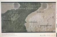
Looks like they're sticking to the "Smooth Unit" and avoiding the "Fractured Unit".
|
|
|
|
|
|
|
Mar 6 2021, 07:39 PM
Post
#26
|
|
|
Member Group: Members Posts: 240 Joined: 18-July 06 Member No.: 981 |
QUOTE (Steve G @ Mar 6 2021, 04:15 PM) You'd think the Blue path would be more interesting with a large crater and the heat shield not far off the path that I'm certain the engineers would like to have a peek at. Definitely a "Blue" fan too. The crater is like an amphitheater with a view into the layer underlying the main delta. Also smoother driving and will let them make faster progress. I'd love to see photos of the heat shield in its new forever home even from a distance - good test of the zoom cams. |
|
|
|
|
Mar 6 2021, 08:37 PM
Post
#27
|
|
|
Solar System Cartographer Group: Members Posts: 10151 Joined: 5-April 05 From: Canada Member No.: 227 |
This is not the main traverse - they are looking for a place to drop the Belly Pan (which protected Ingenuity from the landing event), and will then return to a smooth area near the landing site to do the helicopter tests. Only after that will the main traverse begin.
Phil -------------------- ... because the Solar System ain't gonna map itself.
Also to be found posting similar content on https://mastodon.social/@PhilStooke Maps for download (free PD: https://upload.wikimedia.org/wikipedia/comm...Cartography.pdf NOTE: everything created by me which I post on UMSF is considered to be in the public domain (NOT CC, public domain) |
|
|
|
|
Mar 6 2021, 08:56 PM
Post
#28
|
||
|
Solar System Cartographer Group: Members Posts: 10151 Joined: 5-April 05 From: Canada Member No.: 227 |
In the absence of Navcam panoramas for each location I am using rather rough Hazcam reprojections to find the points to plot on the map. Here are the sol 14 and sol 15 images.
I think Erwan's site is very good. Phil
-------------------- ... because the Solar System ain't gonna map itself.
Also to be found posting similar content on https://mastodon.social/@PhilStooke Maps for download (free PD: https://upload.wikimedia.org/wikipedia/comm...Cartography.pdf NOTE: everything created by me which I post on UMSF is considered to be in the public domain (NOT CC, public domain) |
|
|
|
|
|
|
Mar 6 2021, 09:36 PM
Post
#29
|
||
|
Member Group: Members Posts: 180 Joined: 31-January 05 From: Brittany (France) Member No.: 164 |
QUOTE (Phil Stooke @ Mar 6 2021, 09:56 PM) In the absence of Navcam panoramas for each location I am using rather rough Hazcam reprojections to find the points to plot on the map. Here are the sol 14 and sol 15 images. I think Erwan's site is very good. Phil
Thank you Phi for your comment ; and there is also an helicopter... -------------------- Erwann |
|
|
|
|
|
|
Mar 7 2021, 03:06 AM
Post
#30
|
|
|
Member Group: Members Posts: 248 Joined: 25-February 21 From: Waltham, Massachussetts, U.S.A. Member No.: 8974 |
I have updated my interactive map based on EDL downlook at
http://bit.ly/PercyMAP with an animation showing the traverse. It is based on geojson path data from the Where is the rover page. The azimuth of the rover is following the path. That means that the first 150 degree turn is not represented. The way point geojson from the web page has additional yaw orientation data and shows for the current position a yaw of 88 degrees which I think corresponds to the front being pointed to the east. Is that what the latest camera images show ? Was there some turning in place on the final position of the last drive ? [edit] The answer was yes. But the traverse continued more on a 72 track. I updated again http://bit.ly/PercyMAP . -------------------- --
Andreas Plesch, andreasplesch at gmail dot com |
|
|
|
|

|
Lo-Fi Version | Time is now: 25th April 2024 - 01:39 AM |
|
RULES AND GUIDELINES Please read the Forum Rules and Guidelines before posting. IMAGE COPYRIGHT |
OPINIONS AND MODERATION Opinions expressed on UnmannedSpaceflight.com are those of the individual posters and do not necessarily reflect the opinions of UnmannedSpaceflight.com or The Planetary Society. The all-volunteer UnmannedSpaceflight.com moderation team is wholly independent of The Planetary Society. The Planetary Society has no influence over decisions made by the UnmannedSpaceflight.com moderators. |
SUPPORT THE FORUM Unmannedspaceflight.com is funded by the Planetary Society. Please consider supporting our work and many other projects by donating to the Society or becoming a member. |
|