Solander Point, Sol 3387 - 3511 (August 4, 2013 - December 12, 2013) |

  |
Solander Point, Sol 3387 - 3511 (August 4, 2013 - December 12, 2013) |
 Dec 3 2013, 08:43 PM Dec 3 2013, 08:43 PM
Post
#256
|
||
 Senior Member  Group: Moderator Posts: 3431 Joined: 11-August 04 From: USA Member No.: 98 |
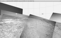
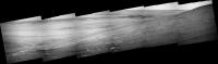
And there it is; nice drive on Sol 3505. This is getting exciting! (At rover speed, of course.)
Attached thumbnail(s)
|
|
 |
 
|
|
|
Dec 3 2013, 09:35 PM
Post
#257
|
|
|
Senior Member Group: Members Posts: 1043 Joined: 17-February 09 Member No.: 4605 |
So is this the outcrop that orbital analysis identified as potentially having clays?
|
|
|
|
|
Dec 3 2013, 09:50 PM
Post
#258
|
|
|
Solar System Cartographer Group: Members Posts: 10154 Joined: 5-April 05 From: Canada Member No.: 227 |
It's a bit to the west of those outcrops.
Phil -------------------- ... because the Solar System ain't gonna map itself.
Also to be found posting similar content on https://mastodon.social/@PhilStooke Maps for download (free PD: https://upload.wikimedia.org/wikipedia/comm...Cartography.pdf NOTE: everything created by me which I post on UMSF is considered to be in the public domain (NOT CC, public domain) |
|
|
|
|
Dec 3 2013, 11:09 PM
Post
#259
|
||
|
Senior Member Group: Moderator Posts: 3431 Joined: 11-August 04 From: USA Member No.: 98 |
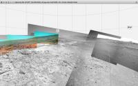
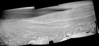
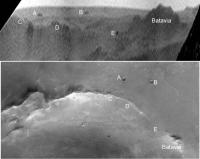
I believe the outcrops in question are visible upper left in the above view. But here's a better view where they're more clearly visible in Pancam false color, on the left.
She'll get over there eventually, I imagine. It's probably just a question of how many things they find to investigate along the way.
Attached thumbnail(s)
|
|
|
|
|
|
|
Dec 3 2013, 11:20 PM
Post
#260
|
|
 Senior Member Group: Members Posts: 4246 Joined: 17-January 05 Member No.: 152 |
QUOTE (mhoward @ Dec 3 2013, 11:09 PM)  here's a better view where they're more clearly visible in Pancam false color, on the left. Looks right - the putative clay outcrops would be the light-toned, flatish-looking outcrops in the mid-background of the colour part of that mosaic. Maybe we'll scout out the area relatively quickly before settling in on some of that outcrop for more detailed studies. |
|
|
|
|
Dec 4 2013, 05:53 AM
Post
#261
|
|
|
Senior Member Group: Members Posts: 4246 Joined: 17-January 05 Member No.: 152 |
Seems the clay signatures are more widespread than it seemed, even extending to where we've already been - from the latest PS report:
QUOTE In November, Opportunity's sites were set on an outcrop dubbed Moreton Island... It's "one of the places" where CRISM... "suggests the presence of clay minerals," said Ray Arvidson And what we identified as the clay region above is now referred to as the "winter wonderland". From our current location, over the next couple of weeks the plan is to QUOTE head further south and east for about 70 meters, just over the top of Murray Ridge, to a place that is temporarily being called the 'winter wonderland,' said Arvidson. "That's probably where we'll try to be in the January to February time frame, through the depths of winter," said Squyres.
|
|
|
|
|
Dec 4 2013, 09:45 AM
Post
#262
|
||
|
Senior Member Group: Members Posts: 2822 Joined: 22-April 05 From: Ridderkerk, Netherlands Member No.: 353 |
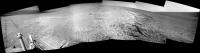
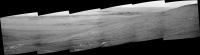
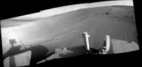
The Navcam L0 view on Sol 3505.
Jan van Driel
|
|
|
|
|
|
|
Dec 4 2013, 10:00 AM
Post
#263
|
||
|
Senior Member Group: Members Posts: 2822 Joined: 22-April 05 From: Ridderkerk, Netherlands Member No.: 353 |
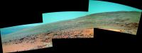
Here is the false colour L257 panorama taken on Sol 3504.
Jan van Driel
|
|
|
|
|
|
|
Dec 4 2013, 10:56 PM
Post
#264
|
|
|
Senior Member Group: Moderator Posts: 3431 Joined: 11-August 04 From: USA Member No.: 98 |
There was another drive on Sol 3506, about 28.7 S-SE. So she's already approaching "Winter Wonderland", and returned a wide L7R1 drive direction mosaic.
That was a lot faster that I was expecting!  Pancam R1 image |
|
|
|
|
Dec 5 2013, 05:31 AM
Post
#265
|
||
 Senior Member Group: Admin Posts: 3108 Joined: 21-December 05 From: Canberra, Australia Member No.: 615 |
Pancam - Sol3506
|
|
|
|
|
|
|
Dec 5 2013, 12:53 PM
Post
#266
|
|||
|
Senior Member Group: Members Posts: 2822 Joined: 22-April 05 From: Ridderkerk, Netherlands Member No.: 353 |
Sol 3506
Navcam
Pancam
Jan van Driel |
||
|
|
|
||
|
Dec 5 2013, 03:28 PM
Post
#267
|
|||
|
Solar System Cartographer Group: Members Posts: 10154 Joined: 5-April 05 From: Canada Member No.: 227 |
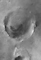
For anyone who's interested, here is a THEMIS visible mosaic of Endeavour crater:
and this is the horizon taken from Astro0's pancam mosaic, vertically stretched to separate features a bit and compared with the THEMIS mosaic (rotated). Two craters on the plains beyond Endeavour's far rim are now visible.
Phil -------------------- ... because the Solar System ain't gonna map itself.
Also to be found posting similar content on https://mastodon.social/@PhilStooke Maps for download (free PD: https://upload.wikimedia.org/wikipedia/comm...Cartography.pdf NOTE: everything created by me which I post on UMSF is considered to be in the public domain (NOT CC, public domain) |
||
|
|
|
||
|
Dec 5 2013, 07:17 PM
Post
#268
|
||
|
Senior Member Group: Moderator Posts: 3431 Joined: 11-August 04 From: USA Member No.: 98 |
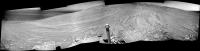
Another drive on Sol 3507! Approximately 19.4m at 158º from north (that S-SE). I think she's more or less at the western end of the bright outcrop area. Things should be even more interesting from here on!

Attached thumbnail(s)
|
|
|
|
|
|
|
Dec 5 2013, 08:55 PM
Post
#269
|
||
|
Senior Member Group: Members Posts: 2822 Joined: 22-April 05 From: Ridderkerk, Netherlands Member No.: 353 |
The R0 Navcam view on Sol 3507
Jan van Driel
|
|
|
|
|
|
|
Dec 5 2013, 09:34 PM
Post
#270
|
||
|
Senior Member Group: Members Posts: 2822 Joined: 22-April 05 From: Ridderkerk, Netherlands Member No.: 353 |
Sol 3506-3507 L0.
Added 3 images to the right. Jan van Driel
|
|
|
|
|
|
|

|
Lo-Fi Version | Time is now: 2nd May 2024 - 01:47 AM |
|
RULES AND GUIDELINES Please read the Forum Rules and Guidelines before posting. IMAGE COPYRIGHT |
OPINIONS AND MODERATION Opinions expressed on UnmannedSpaceflight.com are those of the individual posters and do not necessarily reflect the opinions of UnmannedSpaceflight.com or The Planetary Society. The all-volunteer UnmannedSpaceflight.com moderation team is wholly independent of The Planetary Society. The Planetary Society has no influence over decisions made by the UnmannedSpaceflight.com moderators. |
SUPPORT THE FORUM Unmannedspaceflight.com is funded by the Planetary Society. Please consider supporting our work and many other projects by donating to the Society or becoming a member. |
|