New Horizons: Near Encounter Phase |

  |
New Horizons: Near Encounter Phase |
 Jul 25 2015, 08:16 AM Jul 25 2015, 08:16 AM
Post
#1186
|
|
|
Senior Member  Group: Members Posts: 2922 Joined: 14-February 06 From: Very close to the Pyrénées Mountains (France) Member No.: 682 |
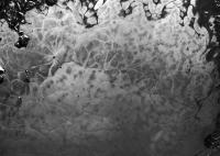
Yes, Herobrine, I can spend hours staring at your stitch. All those "bubbles" and convections remind me now of Jupiter atmosphere.
-------------------- |
 |
 
|
|
Jul 25 2015, 08:21 AM
Post
#1187
|
||
 SewingMachine Group: Members Posts: 316 Joined: 27-September 05 From: Seattle Member No.: 510 |
Cropped and stretched from Herobrine's mosaic:
Dan Delany spoke of perceiving transparency in the ice in post #1027. Looking at this multitude of dark fuzzy dots and smudges, it's very easy to imagine the broken and sunken wreckage of Cthulhu and environs peeking through a frozen sea. -------------------- ...if you don't like my melody, i'll sing it in a major key, i'll sing it very happily. heavens! everybody's all aboard? let's take it back to that minor chord...
Exploitcorporations on Flickr (in progress) : https://www.flickr.com/photos/135024395@N07/ |
|
|
|
|
|
|
Jul 25 2015, 09:01 AM
Post
#1188
|
||
 Member Group: Members Posts: 238 Joined: 15-January 13 Member No.: 6842 |
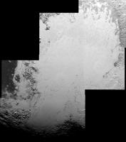
My mosaic, assembled in Microsoft ICE (with one frame added and blended manually, as the software couldn't register it), auto-levelled and rotated so that north is approximately up:
Medium rez: http://s12.postimg.org/mv0o1jj59/lor_02991...3_stitchwow.jpg Full rez: http://www.flickr.com/photos/wildespace/19803197558 Makes me wanna ride a snowbike or deer sledge across those plains. -------------------- Curiosity rover panoramas: http://www.facebook.com/CuriosityRoverPanoramas
My Photosynth panoramas: http://photosynth.net/userprofilepage.aspx...;content=Synths |
|
|
|
|
|
|
Jul 25 2015, 09:19 AM
Post
#1189
|
|
|
Merciless Robot Group: Admin Posts: 8785 Joined: 8-December 05 From: Los Angeles Member No.: 602 |
Stepped away for a bit in anticipation of the UMSF imagewizards doing what you all do best...never a disappointment!!! Thank you.
What an astonishingly strange landscape. Hard for me to see any analogues with Triton at all now in terms of landforms. Few if any familiar processes immediately evident aside from cratering given that the behavior of N2 glaciers at 0.06g is probably gonna differ in subtle ways from water ice glaciers on Earth. Been a pretty good 4-5% of total data thus far. 
-------------------- A few will take this knowledge and use this power of a dream realized as a force for change, an impetus for further discovery to make less ancient dreams real.
|
|
|
|
|
Jul 25 2015, 10:03 AM
Post
#1190
|
|
|
Member Group: Members Posts: 153 Joined: 20-December 14 From: Eastbourne, UK Member No.: 7372 |
QUOTE (Exploitcorporations @ Jul 25 2015, 09:21 AM)  Dan Delany spoke of perceiving transparency in the ice in post #1027. Looking at this multitude of dark fuzzy dots and smudges, it's very easy to imagine the broken and sunken wreckage of Cthulhu and environs peeking through a frozen sea. On the larger scale mosaic image it is possible to define quite well the topology of the surface beneath the ice. There are similarly shaped formations all over Pluto as Dvandorn pointed out, recording a long history of impacts with other icy KBOs and the round craters that record secondary impacts MOD NOTE/EDIT: The mechanism by which the Plutonian satellite system formed has not been positively determined; please don't state what is at this time merely one hypothesis as a fact. https://www.flickr.com/photos/124013840@N06...eposted-public/ EDIT:- Indeed! "possible fallout". Here is an unannotated version of the above. https://www.flickr.com/photos/124013840@N06...eposted-public/ |
|
|
|
|
Jul 25 2015, 11:40 AM
Post
#1191
|
|
|
Newbie Group: Members Posts: 4 Joined: 29-June 15 Member No.: 7535 |
(Beautiful images, thank you all!)
The following is speculation from a newbie... I have been trying to create a mental image of a temperature map superimposed on the images of Tombaugh Regio, and trying to imagine how the temperature changes with time in this region, as Pluto's year progresses. It seems to me that the upper part of the heart is more fluid than the lower part which is more frozen, which seems natural given that, as I understand it, it has been receiving more sunlight on average (it's closer to the center of the iluminated hemisphere). Making an analogy with the Earth and thinking that the exterior of the heart is "land" and that the heart is "ocean" (viscuous/solid/freezing), and supposing that the heat capacity is different ("land" heats/cools more than "ocean"), it could help explaining that the little peaks that appear in the heart ("islands") would be hotter and that cell boundaries would tend to be located there, freezing later than the central parts of the cells. I am assuming that boundaries are locally warmer, freezing later. It would then seem natural that boundaries seem to irradiate from these peaks/islands, tending to join other islands. In this view, darker cells would tend to be shallower/warmer regions (where "ocean" would be closer to hotter "land" - but note that there are other factors too, such as proximity to the regions receiving more sunlight, etc) and white cells would be more frozen. In that case, if Pluto is approaching a sort of "Winter", the upper part of the heart would also freeze and become whiter as time passes. The small islands in the heart, and also mountains close to the "ocean" seem to be eroded, possibly because the ocean ciclically expands and contracts, raising and lowering its average level, causing friction in the islands (which also creates heat, contributing to a slightly higher temperature near the islands/shore/cell boundaries). (of course, this is a huge simplification... another look near the upper shore of the heart made me wonder at all the slow movement that may be occuring along the submerged valleys/hills... there should be more movement in regions far from from the static shore, so it's much more complicated...) |
|
|
|
|
Jul 25 2015, 12:28 PM
Post
#1192
|
|
|
Member Group: Members Posts: 153 Joined: 20-December 14 From: Eastbourne, UK Member No.: 7372 |
Your ideas describe the surface influences very nicely. The proposed curtains of darker Talus at the base of mountains, would absorb more energy and be "warmer" than the surrounding ice hills. Patches of older surface showing through the ice would tend to expand and exert pressure on the icy polygons, possibly creating their convex profiles. Under the ice influences seem to play a significant role too. Trapped gases under the ice, as discussed in the briefing.
|
|
|
|
|
Jul 25 2015, 12:39 PM
Post
#1193
|
|
 Member Group: Members Posts: 423 Joined: 13-November 14 From: Norway Member No.: 7310 |
A breached crater wall in an area that looks like it has experienced, or is, some sort of flow (i.e. notice the flat and smooth terrain):
 A crater that looks like it has a valley entering into it: 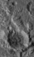 An analogy to Martian river valleys? -------------------- |
|
|
|
|
Jul 25 2015, 12:43 PM
Post
#1194
|
||
 Senior Member Group: Members Posts: 1657 Joined: 5-March 05 From: Boulder, CO Member No.: 184 |
QUOTE (Exploitcorporations @ Jul 25 2015, 04:43 AM) Here's my take on the seven available frames of the LORRI mosiac of Charon (rimshot): I recall saying to someone earlier that the science teams would have some regrets about not seeing the intriguing Charon-facing hemisphere, but it seems now that they couldn't have planned this better. Nice to see you on the forum again Exploit, and thanks for posting this mosaic. Lots to explore in this for a while. Perhaps this was planned to aim the flyby to see the Heart closeup, based on the HST and Eclipse data from the past decades? Here is a 4K map version that I can now post.
This has the new 2x2 mosaic included that approaches being sufficient for a map at this resolution. I also included some additional approach images, and improved the navigation and colorizing. -------------------- Steve [ my home page and planetary maps page ]
|
|
|
|
|
|
|
Jul 25 2015, 12:51 PM
Post
#1195
|
|
|
Member Group: Members Posts: 423 Joined: 13-November 14 From: Norway Member No.: 7310 |
QUOTE (scalbers @ Jul 25 2015, 02:43 PM) Perhaps this was planned to aim the flyby to see the Heart closeup, based on the HST and Eclipse data from the past decades Yes, as was brought up earlier, this part of Pluto was known to have a unique carbon monoxide signature (2005) and was therefore specifically selected for closer investigation. -------------------- |
|
|
|
|
Jul 25 2015, 12:56 PM
Post
#1196
|
|
|
Senior Member Group: Members Posts: 1657 Joined: 5-March 05 From: Boulder, CO Member No.: 184 |
Thanks for the reminder. It's interesting that the albedo variations of the Heart also show up in the HST/Eclipse maps.
-------------------- Steve [ my home page and planetary maps page ]
|
|
|
|
|
Jul 25 2015, 01:07 PM
Post
#1197
|
|
|
Senior Member Group: Members Posts: 3002 Joined: 30-October 04 Member No.: 105 |
QUOTE (Sherbert @ Jul 25 2015, 05:03 AM) On the MOD Ultreya! By all means... Ultreya! Ultreya! -------------------- |
|
|
|
|
Jul 25 2015, 01:32 PM
Post
#1198
|
||
|
Member Group: Members Posts: 238 Joined: 15-January 13 Member No.: 6842 |
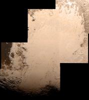
An attempt to colourise the my mosaic with Ralph data (from the global high-rez image link)
I couldn't align all the features, but I think the result is decent. ~~~ I am wondering, which Ralph image was used for this colour data, and can we access it anywhere? I have a suspicion that the Ralph image that is being used is low-rez, and thus gives a more uniform colouration, lacking in smaller details. The global views we've seen so far are almost monochrome. -------------------- Curiosity rover panoramas: http://www.facebook.com/CuriosityRoverPanoramas
My Photosynth panoramas: http://photosynth.net/userprofilepage.aspx...;content=Synths |
|
|
|
|
|
|
Jul 25 2015, 01:48 PM
Post
#1199
|
|
|
Junior Member Group: Members Posts: 71 Joined: 3-February 11 Member No.: 5800 |
Great stuff people.
I just want to make a small observation that the large craters in the dark "Cthulu" region, which is surmised to be billions of years old, don't look that eroded to me. You can still see central peaks in some of them, and the rims look crisp. Of course some processes on earth are different, however for comparison, Manicouagan crater is only 200 million years old, and has been run over by glaciers, probably several times. OTOH, the craters inside of Tombaugh regio look battered and flattened, somewhat similar to Manicouagan . So, like earth, Pluto's glaciers are a regional, local and not global phenomenon? https://en.wikipedia.org/wiki/Manicouagan_crater |
|
|
|
|
Jul 25 2015, 02:13 PM
Post
#1200
|
|
|
Senior Member Group: Members Posts: 3002 Joined: 30-October 04 Member No.: 105 |
I'm starting work on a Poster Session on the Geomorphology of Pluto.
It's a work-in-progress, but here is the initial Index image: https://univ.smugmug.com/New-Horizons-Missi...ron/ --Bill -------------------- |
|
|
|
|

|
Lo-Fi Version | Time is now: 26th July 2024 - 11:44 PM |
|
RULES AND GUIDELINES Please read the Forum Rules and Guidelines before posting. IMAGE COPYRIGHT |
OPINIONS AND MODERATION Opinions expressed on UnmannedSpaceflight.com are those of the individual posters and do not necessarily reflect the opinions of UnmannedSpaceflight.com or The Planetary Society. The all-volunteer UnmannedSpaceflight.com moderation team is wholly independent of The Planetary Society. The Planetary Society has no influence over decisions made by the UnmannedSpaceflight.com moderators. |
SUPPORT THE FORUM Unmannedspaceflight.com is funded by the Planetary Society. Please consider supporting our work and many other projects by donating to the Society or becoming a member. |
|