Printable Version of Topic
Click here to view this topic in its original format
Unmanned Spaceflight.com _ Titan _ T77 Flyby (June 20, 2011 / Rev 149)
Posted by: Juramike Jun 16 2011, 11:35 AM
T77 Flyby Quick Facts description now up: http://saturn.jpl.nasa.gov/files/20110620_Titan77_flyby_quicklook.pdf
And the Looking Ahead for Rev 149 from CICLOPS: http://www.ciclops.org/view/6787/Rev149
Most of the RADAR modes being used: radiometry, scatterometry, altimetry, HiSAR, and an SAR Swath near Ksa crater.
Might get a neat 3D view of the crater and ejecta pattern when combined with T17 data.
Posted by: Phil Stooke Jun 16 2011, 12:17 PM
This looking like a great orbit... Go Cassini!
(I'm on vacation in Europe but back to the proverbial grindstone, AKA frequent UMSF posting, soon)
Phil
Posted by: stevesliva Jun 16 2011, 06:31 PM
The plasma spectrometer is causing wonky things on a voltage bus and is shut off right now... looks like the pointing for this orbit means it's not missing much?
Posted by: toddbronco2 Jun 17 2011, 01:49 AM
CAPS isn't the prime team for an observation until the 4th of July and then not again until near the end of July.
I'm just hoping that for this Helene flyby the error in the moon's location is smaller than last time so that we actually see it throughout the flyby.
Posted by: titanicrivers Jun 20 2011, 08:36 AM

Agree!
The crater is located on VP's swath maps below (with a grid added). Perhaps it will look a little like the 3D construction below
|
|
|
Posted by: Juramike Jun 24 2011, 03:14 AM
Mosaic made from raw images taken during the flyby (had to use WAC images to fill in the northeast section.)
|
Posted by: titanicrivers Jul 6 2011, 09:20 AM
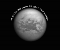
Nice one Mike. Heres another taken with the NAC on June 23rd from 1.44M km. The image is centered on Belet and the area recently inundated by the T72 arrow storm. Of interest this area was within the estimated origin of the previous tropical storm in April of 2008. Likely this area received methane precip back then as well. Makes one wonder if this area was relatively more saturated with methane when the arrow storm passed by in Oct. 2010 making the changes from the latter storm more prominent than any other area in its path. The images below are animated to show the T77 image, its coverage on VPs SAR swath map, the area inundated by the arrow storm (from the Science paper of Turtle et al http://www.sciencemag.org/content/331/6023/1414 and finally the estimated location of the 2008 storm origin (green square in the Gemini N image from the Schaller et al paper http://www.nature.com/nature/journal/v460/n7257/abs/nature08193.html
|
Posted by: volcanopele Jul 6 2011, 07:01 PM
Keep in mind that our image coverage in the weeks and months after last year's storm played a role in where we mapped the areas where we saw changes. We can't rule out that similar dark swaths would have been seen further west in late October had we had the surface coverage.
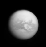
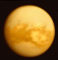
Posted by: Navin Aug 2 2011, 07:09 PM
http://photojournal.jpl.nasa.gov/catalog/PIA14500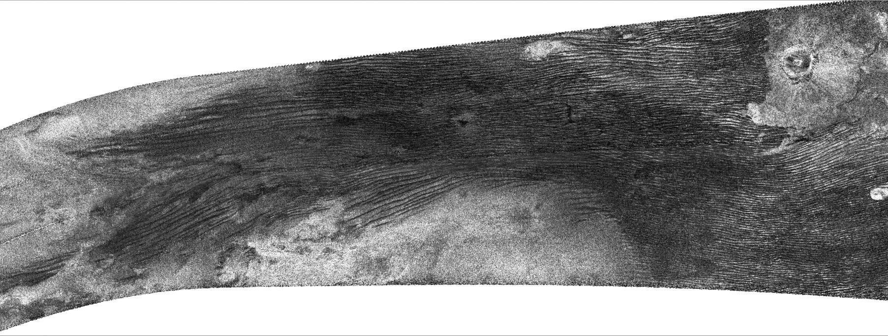
Wow! So familiar, yet so alien.
Posted by: HughFromAlice Aug 5 2011, 01:01 PM
Just a bit of fun as part of getting back into the habit of posting. Took your Titan pic and pushed to the limits of what I could do in a short time..... a rather free interpretation but it's just about worth posting!!
|
So I might as well post it. And Mike....just checked out your Flikr pages and they are great :-)
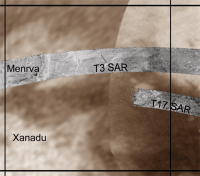
Posted by: titanicrivers Aug 9 2011, 12:52 PM
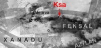
WoW is right! The Ksa crater and the dune relationship to Xanadu's border are fascinating. Based on the Photojournal description I've tried to place the swath on a gridded map, the borders of which are 0 to 30 degrees North latitude and 60 to 90 degrees W longitude.
|
Posted by: machi Apr 2 2012, 08:34 PM
http://pds-imaging.jpl.nasa.gov/data/cassini/cassini_orbiter/CORADR_0229/DATA/BIDR/ are now available at PDS archive.
Three big craters are visible in those SARs - Ksa, Momoy and Menrva, last one is visible in this cropped image (resolution 1 km/pix, slightly improved by denoising filter from Florian Luisier, EPFL, Switzerland):
|
Posted by: ngunn Apr 2 2012, 10:12 PM
Nice. 
I don't seem to be able to find the rest of the swath via the link in your post. I'm still waiting for Jason's SAR gallery to get past T65.
Posted by: algorimancer Apr 4 2012, 01:46 PM
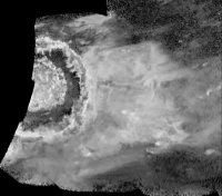
Is that actual layering I see in that crater? It seems too finely bound to simply be rough terrain associated with mass wasting.
Posted by: volcanopele Apr 4 2012, 09:57 PM
Going to try to get the T71 and T77 swaths up in the next couple of hours. In the mean time, here is a stereo image of Ksa.
http://pirlwww.lpl.arizona.edu/~perry/RADAR/Ksa_Stereo_T17_T77.png
Posted by: volcanopele Apr 4 2012, 11:38 PM
T71 and T77 swaths now up:
http://pirlwww.lpl.arizona.edu/~perry/RADAR/
Posted by: ngunn Apr 5 2012, 11:10 AM
Thanks Jason.
Powered by Invision Power Board (http://www.invisionboard.com)
© Invision Power Services (http://www.invisionpower.com)