Spirit Route Map, Small and Large Scales |

  |
Spirit Route Map, Small and Large Scales |
 Jul 6 2005, 12:36 PM Jul 6 2005, 12:36 PM
Post
#136
|
|
|
Member  Group: Members Posts: 320 Joined: 19-June 04 Member No.: 85 |
Latest Spirit route map takes us to sol 532. Summit 2 "only" 125 metres away!
http://marsrovers.jpl.nasa.gov/mission/traverse_maps.html 
-------------------- |
 |
 
|
|
Aug 30 2005, 05:36 PM
Post
#137
|
|
|
Member Group: Members Posts: 129 Joined: 25-March 05 Member No.: 218 |
New Spirit & Oppy route maps out at JPL (30 Aug):
http://marsrovers.jpl.nasa.gov/mission/traverse_maps.html (new day-by-day summaries out for both, too) (Edited: Look at the last (wide-view) Spirit map at full size... .and look REAL CLOSELY into the Ultreya Abyss! You'll see evidence for artificial intelligence!  
|
|
|
|
| Guest_Myran_* |
Aug 30 2005, 06:49 PM
Post
#138
|
|
Guests |
Yes ive seen it, I bet its Marvin who have went ahead to place a yardstick there.
Only question now is what Daffy are up to? (Marvin the Martian and Daffy Duck official mascots for this mission but I bet most know that http://www.space.com/images/h_mer_patches_02.jpg)) |
|
|
|
|
Sep 2 2005, 09:45 AM
Post
#139
|
|
 Member Group: Members Posts: 531 Joined: 24-August 05 Member No.: 471 |
-------------------- - blue_scape / Nico -
|
|
|
|
|
Sep 2 2005, 07:21 PM
Post
#140
|
|
|
Member Group: Members Posts: 252 Joined: 5-May 05 From: Mississippi (USA) Member No.: 379 |
QUOTE (SigurRosFan @ Sep 2 2005, 05:45 AM) Now I know why Tennessee valley doesn't look like a vally. It's miissing most of one side! GREAT OVERVIEW Jack . |
|
|
|
|
Sep 9 2005, 02:08 PM
Post
#141
|
|
|
Member Group: Members Posts: 531 Joined: 24-August 05 Member No.: 471 |
-------------------- - blue_scape / Nico -
|
|
|
|
|
Sep 10 2005, 07:02 AM
Post
#142
|
||
 Senior Member Group: Members Posts: 2492 Joined: 15-January 05 From: center Italy Member No.: 150 |
 In order to celebrate Sol600, here a summary of daily/cumulative odometry I made from the mission start of both rovers (average is calculated from differences between total odometry reported values):
Attached thumbnail(s)
-------------------- I always think before posting! - Marco -
|
|
|
|
|
|
|
Sep 19 2005, 07:58 PM
Post
#143
|
|
|
Member Group: Members Posts: 236 Joined: 21-June 05 Member No.: 417 |
New traverse maps for Spirit:
http://marsrovers.jpl.nasa.gov/mission/tm-spirit/index.html |
|
|
|
|
Oct 1 2005, 10:36 AM
Post
#144
|
||
|
Senior Member Group: Members Posts: 2492 Joined: 15-January 05 From: center Italy Member No.: 150 |
maybe interesting to see this pseudo-vertical projection from the "true summit" (Sol619), with identificable traces/maneuvers from previous Sols. Thanks again Michael, for MMB!!!!
Attached thumbnail(s)
-------------------- I always think before posting! - Marco -
|
|
|
|
|
|
|
Oct 5 2005, 02:40 PM
Post
#145
|
|
|
Junior Member Group: Members Posts: 67 Joined: 18-April 05 From: Austin, Texas Member No.: 249 |
Is this Steve's first mention of the Ultreya Abyss? I wonder if it is a direct or in indirect result of his conversation with Doug?
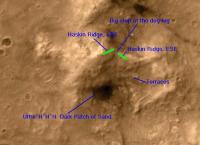
"If we can get down onto the lower part of the ridge, we'll eventually hang a hard right turn and head south, toward Home Plate, crossing some interesting-looking terraces and passing just to the east of a dark patch of sand as we do." Doug, at one time in another thread you posted a 3-D topographical map of Husband Hill. Alas I cannot find it. I thought it might be a useful instrument to follow the planned path for Spirit downhill, as outline in Squyre's latest update. Do you still have access to it and if so, can you post it again? Thanks |
|
|
|
|
Oct 5 2005, 03:49 PM
Post
#146
|
|
|
Founder Group: Chairman Posts: 14432 Joined: 8-February 04 Member No.: 1 |
QUOTE (Phillip @ Oct 5 2005, 02:40 PM) Do you still have access to it and if so, can you post it again?  Unfortunately, it doesn include anything beyond the Summit basically. http://www.unmannedspaceflight.com/doug_images/elev_2.jpg If there's more contour data around, I'll be more than happy to do the work Doug |
|
|
|
|
Oct 5 2005, 05:15 PM
Post
#147
|
||
 Member Group: Members Posts: 510 Joined: 17-March 05 From: Southeast Michigan Member No.: 209 |
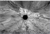
Here's my guess from this MGS image, which I rotated so north is up:
Or does the ENE portion of the ridge continue further east? -------------------- --O'Dave
|
|
|
|
|
|
|
Oct 11 2005, 09:43 AM
Post
#148
|
|
|
Senior Member Group: Moderator Posts: 4279 Joined: 19-April 05 From: .br at .es Member No.: 253 |
Hi all,
Now that Spirit will start moving again down to the Inner Basin, I was thinking on how to plot a fairly precise route map, without the need to depend on the traverse maps from the MER webpage. I'm afraid that Dilo's superb work on Oppy's route map wouldn't be applicable here; it needs a quite good terrain modeling to produce precise results. Another option would be with the use of polar projections and trying to match the headings to medium/far range features on the route map and on the projection. But this method has an error quite high if compared to the expected drives in the 5-30m range. A third one would be to estimate the rover movement (heading/distance) by pinpointing similar features on before-drive and after-drive navcam/pancam images. But again, this method has a drawback: it accumulates the errors drive after drive. At the end, I don't know which is the best method -- or let's say the "less worst" -- to plot the route map. Comments are welcome. |
|
|
|
|
Oct 11 2005, 01:50 PM
Post
#149
|
|
|
Solar System Cartographer Group: Members Posts: 10160 Joined: 5-April 05 From: Canada Member No.: 227 |
I would suggest that the most likely method to produce reasonable results would be a combination.
Dilo's method could produce reasonable results with a simple correction for the mean slope of each area. Areas of more complex morphology would be troublesome but Spirit will tend to avoid them anyway. The second option - polar projections and headings to medium-long range features is good but accumulates errors, as Tesheiner says. The third option is more like 'dead reckoning', estimating travel distance and direction, and accumulates errors as well. All three methods will give a rough path. But at intervals of - let's say - 200 m the position could be checked more carefully with azimuths to major features in the surrounding landscape. That can help get the route back on course. If it has drifted off by 25 m, a corrected map can be made with the correction distributed over the whole journey since the last check. In effect this is what the MER team will be doing, with Ron Li's bundle adjustment work used to correct Larry Crumpler's day by day mapping. We saw evidence of this in a Spirit map release earlier where the two positions were both plotted. I eagerly await any effort to do this! Incidentally, even when this glorious mission ends there will be lots of good work to do retrospectively with this kind of approach. Imagine a Dilo-style map of the interior of Endurance, using a rough shape model to correct for tilt! Phil -------------------- ... because the Solar System ain't gonna map itself.
Also to be found posting similar content on https://mastodon.social/@PhilStooke Maps for download (free PD: https://upload.wikimedia.org/wikipedia/comm...Cartography.pdf NOTE: everything created by me which I post on UMSF is considered to be in the public domain (NOT CC, public domain) |
|
|
|
|
Oct 12 2005, 12:06 AM
Post
#150
|
|
|
Senior Member Group: Members Posts: 2492 Joined: 15-January 05 From: center Italy Member No.: 150 |
I think combination of the three methods + distant features azimuth localization could give good results...
There is a fourth "absolute" method based on the massive use of parallax calculation in order to obtain a true 3D terrain model; however, if done manually, it would be extremely time-consuming  About first method, note that there is a useful shortcut in using the locally-planar projection (or even its approximate version produced with MMB - see my last post in this thread): you can use rover tracks as a gauge for the best local terrain approximation... if done through a rendering software like PovRay, this could give local terrain slope/orientation! If I will have enough time, I will make a try... meanwhile, someone else can do the same using MMB panoramas.  PS: Phil, it seems you deeply knows the Mer team members/jobs... -------------------- I always think before posting! - Marco -
|
|
|
|
|

|
Lo-Fi Version | Time is now: 11th May 2024 - 04:48 AM |
|
RULES AND GUIDELINES Please read the Forum Rules and Guidelines before posting. IMAGE COPYRIGHT |
OPINIONS AND MODERATION Opinions expressed on UnmannedSpaceflight.com are those of the individual posters and do not necessarily reflect the opinions of UnmannedSpaceflight.com or The Planetary Society. The all-volunteer UnmannedSpaceflight.com moderation team is wholly independent of The Planetary Society. The Planetary Society has no influence over decisions made by the UnmannedSpaceflight.com moderators. |
SUPPORT THE FORUM Unmannedspaceflight.com is funded by the Planetary Society. Please consider supporting our work and many other projects by donating to the Society or becoming a member. |
|