Printable Version of Topic
Click here to view this topic in its original format
Unmanned Spaceflight.com _ Uranus and Neptune _ Miranda topography
Posted by: DrShank Sep 11 2009, 04:08 AM
I have posted the new Miranda flyover movie (its a work in progress!), based on the newest high resolution topographic map of same, on Facebook and on http://stereomoons.blogspot.com
enjoy and leave lots o comments!
paul
|
Posted by: antipode Sep 12 2009, 09:53 PM
Wow! One of my fave moons. Thank you for your exiting new perspectives from this data set! The Uranian system seems like the black sheep of the solar system sometimes (the planet is bland [not lately!], the moons are small [so?, so is Iapetus], the inclination is awkward to design missions to [Argo *might* go to Neptune, is anyone seriously proposing a Uranus mission?] etc etc).
Does your image of Verona Rupes and Inverness Corona include the famous 10km (or was it 20km) cliff, or is that somewhere else? Are you going to add work for the other, less well imaged moons?
P
Edit: I just noticed your Ariel work on the blog - I should have gone there first!
Posted by: DrShank Sep 13 2009, 01:59 PM

Does your image of Verona Rupes and Inverness Corona include the famous 10km (or was it 20km) cliff, or is that somewhere else? Are you going to add work for the other, less well imaged moons?
P
Edit: I just noticed your Ariel work on the blog - I should have gone there first!
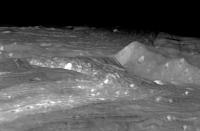
The Verona cliff is just off to the right in this frame. It shows up on approach in the movie, now also on Facebook and Youtube. It may also show on some of the clips on the stereomoons blog
paul
Posted by: Tayfun Öner Nov 13 2009, 12:10 PM
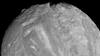
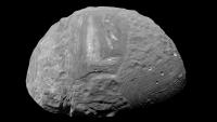
This is what it looks like when Dr. Schenk's image and topography maps are projected on a sphere.
|
|
Powered by Invision Power Board (http://www.invisionboard.com)
© Invision Power Services (http://www.invisionpower.com)