MSL Route Map |

  |
MSL Route Map |
 Jan 14 2017, 04:22 AM Jan 14 2017, 04:22 AM
Post
#916
|
||
|
Solar System Cartographer  Group: Members Posts: 10158 Joined: 5-April 05 From: Canada Member No.: 227 |
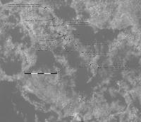
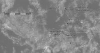
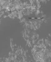
Update to sol 1581. Nearly time to look for a new base map.
Phil
-------------------- ... because the Solar System ain't gonna map itself.
Also to be found posting similar content on https://mastodon.social/@PhilStooke Maps for download (free PD: https://upload.wikimedia.org/wikipedia/comm...Cartography.pdf NOTE: everything created by me which I post on UMSF is considered to be in the public domain (NOT CC, public domain) |
|
 |
 
|
|
|
Jan 18 2017, 12:22 AM
Post
#917
|
||
|
Solar System Cartographer Group: Members Posts: 10158 Joined: 5-April 05 From: Canada Member No.: 227 |
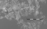
Update for sol 1582.
Phil
-------------------- ... because the Solar System ain't gonna map itself.
Also to be found posting similar content on https://mastodon.social/@PhilStooke Maps for download (free PD: https://upload.wikimedia.org/wikipedia/comm...Cartography.pdf NOTE: everything created by me which I post on UMSF is considered to be in the public domain (NOT CC, public domain) |
|
|
|
|
|
|
Jan 19 2017, 12:31 AM
Post
#918
|
||
|
Solar System Cartographer Group: Members Posts: 10158 Joined: 5-April 05 From: Canada Member No.: 227 |
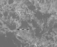
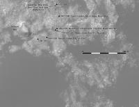
Update and a few path corrections for the last few sols. We have a clear path to Ireson Hill now, if that is the plan.
Phil
-------------------- ... because the Solar System ain't gonna map itself.
Also to be found posting similar content on https://mastodon.social/@PhilStooke Maps for download (free PD: https://upload.wikimedia.org/wikipedia/comm...Cartography.pdf NOTE: everything created by me which I post on UMSF is considered to be in the public domain (NOT CC, public domain) |
|
|
|
|
|
|
Jan 20 2017, 12:51 AM
Post
#919
|
||
|
Solar System Cartographer Group: Members Posts: 10158 Joined: 5-April 05 From: Canada Member No.: 227 |
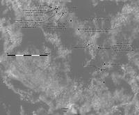
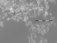
Sol 1584, zig-zagging through the sandy patches, and now only 100 m from Ireson Hill.
Phil
-------------------- ... because the Solar System ain't gonna map itself.
Also to be found posting similar content on https://mastodon.social/@PhilStooke Maps for download (free PD: https://upload.wikimedia.org/wikipedia/comm...Cartography.pdf NOTE: everything created by me which I post on UMSF is considered to be in the public domain (NOT CC, public domain) |
|
|
|
|
|
|
Jan 21 2017, 12:48 AM
Post
#920
|
||
|
Solar System Cartographer Group: Members Posts: 10158 Joined: 5-April 05 From: Canada Member No.: 227 |
We had s short drive, only 15 m or so, roughly south, to get to a tasty bit of rock. To the hill next time? We'll see.
Phil
-------------------- ... because the Solar System ain't gonna map itself.
Also to be found posting similar content on https://mastodon.social/@PhilStooke Maps for download (free PD: https://upload.wikimedia.org/wikipedia/comm...Cartography.pdf NOTE: everything created by me which I post on UMSF is considered to be in the public domain (NOT CC, public domain) |
|
|
|
|
|
|
Jan 23 2017, 04:40 AM
Post
#921
|
||
|
Solar System Cartographer Group: Members Posts: 10158 Joined: 5-April 05 From: Canada Member No.: 227 |
Sol 1587, a drive to the south. Will we turn west and look at the hill?
Phil
-------------------- ... because the Solar System ain't gonna map itself.
Also to be found posting similar content on https://mastodon.social/@PhilStooke Maps for download (free PD: https://upload.wikimedia.org/wikipedia/comm...Cartography.pdf NOTE: everything created by me which I post on UMSF is considered to be in the public domain (NOT CC, public domain) |
|
|
|
|
|
|
Jan 23 2017, 09:13 AM
Post
#922
|
|
|
Senior Member Group: Members Posts: 3516 Joined: 4-November 05 From: North Wales Member No.: 542 |
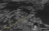
It would appear from this smaller scale route map previously posted by centsworth: http://mars.jpl.nasa.gov/msl/multimedia/images/?ImageID=6584 that the most constricted part of the clear route between the dunes lies just souh of Ireson Hill. However the details of the gap are obscured by the thickness of the projected route line there. It will be interesting to see how that area looks on your large scale route map Phil.
|
|
|
|
|
Jan 23 2017, 08:08 PM
Post
#923
|
||
|
Solar System Cartographer Group: Members Posts: 10158 Joined: 5-April 05 From: Canada Member No.: 227 |
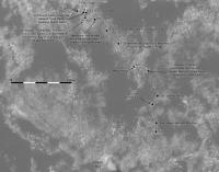
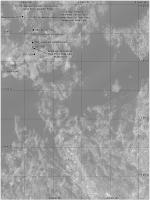
This new section of my overview map set shows the path ahead.
Phil
-------------------- ... because the Solar System ain't gonna map itself.
Also to be found posting similar content on https://mastodon.social/@PhilStooke Maps for download (free PD: https://upload.wikimedia.org/wikipedia/comm...Cartography.pdf NOTE: everything created by me which I post on UMSF is considered to be in the public domain (NOT CC, public domain) |
|
|
|
|
|
|
Jan 23 2017, 11:10 PM
Post
#924
|
|
|
Senior Member Group: Members Posts: 3516 Joined: 4-November 05 From: North Wales Member No.: 542 |
Thanks for posting that: it's exactly what I was hoping to see. The way through the dunes is indeed quite narrow when you consider their extent on either side.
|
|
|
|
|
Jan 25 2017, 03:23 AM
Post
#925
|
||
|
Solar System Cartographer Group: Members Posts: 10158 Joined: 5-April 05 From: Canada Member No.: 227 |
I'm not certain of the location for sol 1589, but this should be fairly close. The drive path is conjectural, made to avoid big rocks.
Phil
-------------------- ... because the Solar System ain't gonna map itself.
Also to be found posting similar content on https://mastodon.social/@PhilStooke Maps for download (free PD: https://upload.wikimedia.org/wikipedia/comm...Cartography.pdf NOTE: everything created by me which I post on UMSF is considered to be in the public domain (NOT CC, public domain) |
|
|
|
|
|
|
Jan 25 2017, 07:15 PM
Post
#926
|
||
 Member Group: Members Posts: 894 Joined: 15-June 09 From: Lisbon, Portugal Member No.: 4824 |
Here is an update to sol 1589. Curiosity is approaching the narrowest gaps yet through the dunes. It is not clear from Emily's 3D map in Post #784 which way is best. And it is all uphill, as the route has been for a while now.
Fernando
 The_Martian_Way_MSL_Curiosity_Sol_1589_2017JAN25.kmz ( 452.54K )
Number of downloads: 254
The_Martian_Way_MSL_Curiosity_Sol_1589_2017JAN25.kmz ( 452.54K )
Number of downloads: 254 |
|
|
|
|
|
|
Jan 28 2017, 01:36 AM
Post
#927
|
||
|
Solar System Cartographer Group: Members Posts: 10158 Joined: 5-April 05 From: Canada Member No.: 227 |
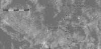
A new basemap for the path through the last bits of dark sand. This includes a correction to the previous drive, where I chose the wrong location. It's not always easy to make a match with so many rocks around us.
Phil
-------------------- ... because the Solar System ain't gonna map itself.
Also to be found posting similar content on https://mastodon.social/@PhilStooke Maps for download (free PD: https://upload.wikimedia.org/wikipedia/comm...Cartography.pdf NOTE: everything created by me which I post on UMSF is considered to be in the public domain (NOT CC, public domain) |
|
|
|
|
|
|
Jan 30 2017, 11:36 PM
Post
#928
|
||
|
Solar System Cartographer Group: Members Posts: 10158 Joined: 5-April 05 From: Canada Member No.: 227 |
A move to the southwest - maybe we will visit the hill now.
Phil
-------------------- ... because the Solar System ain't gonna map itself.
Also to be found posting similar content on https://mastodon.social/@PhilStooke Maps for download (free PD: https://upload.wikimedia.org/wikipedia/comm...Cartography.pdf NOTE: everything created by me which I post on UMSF is considered to be in the public domain (NOT CC, public domain) |
|
|
|
|
|
|
Feb 2 2017, 12:01 AM
Post
#929
|
||
|
Solar System Cartographer Group: Members Posts: 10158 Joined: 5-April 05 From: Canada Member No.: 227 |
We did move closer to the hill again on sol 1596, so the Mastcam view will be pretty good.
Phil
-------------------- ... because the Solar System ain't gonna map itself.
Also to be found posting similar content on https://mastodon.social/@PhilStooke Maps for download (free PD: https://upload.wikimedia.org/wikipedia/comm...Cartography.pdf NOTE: everything created by me which I post on UMSF is considered to be in the public domain (NOT CC, public domain) |
|
|
|
|
|
|
Feb 4 2017, 12:15 AM
Post
#930
|
||
|
Solar System Cartographer Group: Members Posts: 10158 Joined: 5-April 05 From: Canada Member No.: 227 |
Update to sol 1598, approaching the dune science site.
Phil
-------------------- ... because the Solar System ain't gonna map itself.
Also to be found posting similar content on https://mastodon.social/@PhilStooke Maps for download (free PD: https://upload.wikimedia.org/wikipedia/comm...Cartography.pdf NOTE: everything created by me which I post on UMSF is considered to be in the public domain (NOT CC, public domain) |
|
|
|
|
|
|

|
Lo-Fi Version | Time is now: 6th May 2024 - 01:47 AM |
|
RULES AND GUIDELINES Please read the Forum Rules and Guidelines before posting. IMAGE COPYRIGHT |
OPINIONS AND MODERATION Opinions expressed on UnmannedSpaceflight.com are those of the individual posters and do not necessarily reflect the opinions of UnmannedSpaceflight.com or The Planetary Society. The all-volunteer UnmannedSpaceflight.com moderation team is wholly independent of The Planetary Society. The Planetary Society has no influence over decisions made by the UnmannedSpaceflight.com moderators. |
SUPPORT THE FORUM Unmannedspaceflight.com is funded by the Planetary Society. Please consider supporting our work and many other projects by donating to the Society or becoming a member. |
|