Printable Version of Topic
Click here to view this topic in its original format
Unmanned Spaceflight.com _ Tianwen 1- 2020 Orbiter/Lander _ Zhurong Lander/Rover
Posted by: nprev May 14 2021, 05:05 AM
https://twitter.com/MarsZhurong/status/1392718169006030848, landing currently scheduled for 14 May/2300 UTC. Please post any relevant information and updates here.
GO ZHURONG!!!!!
Posted by: Huguet May 14 2021, 12:14 PM
CNSA: "Chinas first Mars exploration mission, Tianwen-1 probe has functioned normally since its successful launch on July 23rd, 2020. On February 10th, 2021, Tianwen-1 probe entered the Martian orbit for scientific exploration and huge amount of scientific data are available up to date. With the evaluation of the flight status, Tianwen-1 probe is scheduled to perform landing campaign targeting Utopia Planitia at the proper slot from the early morning of May 15th to May 19th Beijing time."
http://www.cnsa.gov.cn/english/n6465652/n6465653/c6812000/content.html
Oficial statement from CNSA, so the window starts today 23:00 UTC, but they can skip it and have two more windows beetween 15 and 19, beijing time is UTC + 8, so we have this 3 dates of periapsis for landing, by Edgar Kaiser:
2021.05.14 23:02:44 Start of the Windows of Landing, oficial statement by CNSA
2021.05.17 00:17:35
2021.05.19 01:32:26
https://twitter.com/df2mz/status/1391876766294331395
Interesting point remembering the importance of amateur radio enthusiasts on space exploration. Without then we would be blind.
https://twitter.com/AJ_FI/status/1393164426593902597
Nice Interview with Scott Tilley from British Columbia about listening Tianwen-1 over Mars:
Tianwen-1, on the other hand, has a relatively large antenna with a booming signal. China probably plans to use it as a relay for future Chinese space missions, Tilley speculates. This makes it a good target for hams hoping to bag their first Martian spacecraft.
https://spaceweatherarchive.com/2021/02/16/ham-radio-signals-from-mars/
Posted by: Huguet May 14 2021, 01:26 PM
Live of the landing or skip with radio signals by RocketGyan starting at 22:15 UTC:
https://www.youtube.com/watch?v=TGijtGSUEJs

|
Posted by: Huguet May 14 2021, 03:35 PM
Live signal from Edgar Kaiser, will go live till 23:00, minutes before landing possible attempt, we should get something in 30 minutes indicating if they will try it today.
Now we have two feeders getting tianwen-1, one live, the other will start 22:15 UTC.
The separation would happen more or less at 18:00 UTC if they will try it today, it will be visible at Edgar Kaiser live.
https://www.youtube.com/watch?v=RupTNWUuxsg

|

|
Posted by: Huguet May 14 2021, 04:14 PM
They are doing a maneuver now! Separation... or alignment of orbiter to do the separation... or changing from High Gain to Low Gain Antenna
https://www.youtube.com/watch?v=RupTNWUuxsg
Lost it on Edgar Kaiser, so HGA not available, action done, possible atempt landing today.
Signal lost by an action on orbiter at: 16:09 UTC.
|
Posted by: Huguet May 14 2021, 04:42 PM
Possible cofirmation of landing process happening from Zhurong official weibo account.
"Tianwen1 has entered the landing process! I am expected to start entering the atmosphere of Mars tomorrow (UTC in a few hours) and land at an opportune time"
Landing process started at 16:01 (16:08 minus 7 minutes delay of the signal...)
https://twitter.com/df2mz/status/1393240504020647941
|
Posted by: Huguet May 14 2021, 06:09 PM
Passed separation time, if all goes well we should got a signal 1 hour from now.
AMSAT got a signal from LGA. Everything seens ok.
Posted by: djellison May 14 2021, 06:18 PM
The Amsat DL team with their large antenna in Bochum are tracking it live - https://www.youtube.com/watch?v=hEfAxmkBagg
Posted by: Phil Stooke May 14 2021, 06:25 PM
If we have a successful landing there will be a map thread. It may be very sporadically updated depending on how operations are covered.
Phil
Posted by: Huguet May 14 2021, 06:25 PM

Very nice link, High Gain Antenna back alive!!!!! Everything seens perfect...
Possible Separation ok and orbiter returned to his normal position.
Oh my,... 2 live feeds... 1 more to join,.. this is just so perfect.
|
Posted by: Phil Stooke May 14 2021, 06:35 PM
The landing site is probably the same one indicated at the left here. I have not seen anything specific about the location.
The small crater names were given back in the early 1970s when this area (centered a bit to the west) was considered for Viking under the name Amenthes.
Phil

|
Posted by: Huguet May 14 2021, 06:45 PM
We got a new burn, probably to distance the orbiter from the lander or unlocked something,.. or else...
|
Posted by: kenny May 14 2021, 07:06 PM
Regarding the landing burns, the procedure is apparently to de-orbit the whole assembly (both orbiter and lander) into a descent trajectory which intersects the Martian atmosphere, then release the orbiter. After separation, the orbiter portion does another engine burn to raise itself back into Mars orbit to continue its mission. The lander in its entry shell continues down into the atmosphere. This avoids having to provide separate de-orbit engines for the lander capsule, as was the case with the US Viking probes.
Posted by: Huguet May 14 2021, 07:14 PM
Thanks,.. that can explain the last burn, i think the next lose off HGA will be the orbiter changing its direction to image the landing. we should have that 3 hours from now... so the separation was more a drop maneuver then a normal separation... I expect then to release a nice footage of the heat shield, parachute, burn landing. That would be perfect.
Posted by: Huguet May 14 2021, 08:25 PM
The orbiter just turned from HGA to LGA, possible its starting to image or to follow somehow the lander. Very early to do that, possible it is now making the burn to achieve parking orbit again. Less then 3 hours to heat shield burning.
Its impressive that we are geting a good info from a dish with 1 meter in diameter...
Posted by: Huguet May 14 2021, 10:01 PM
HGA back alive, orbiter possible returned to parking orbit. Everything good to wait for the heat shield burn, that will start in 1 hour.
|
Posted by: kenny May 14 2021, 10:01 PM
The South China Morning Post (Hong Kong) reports : "Ye Peijian, a member of the Chinese Academy of Sciences and a key researcher on China’s lunar programme, said during a Thursday lecture at the Beijing Institute of Technology that the rover would land at about 7.11am Saturday Beijing time, local media reported."
So now that the separation of the lander has apparently occurred, there can be no delay to this plan, as was previously an option. It cannot now return to Mars orbit.
So landing expected at 23.11:30 UTC Friday 14th.
Then I presume we need to add on the current light time for radio signals to arrive from Mars, which is 17 minutes 43 seconds.
So I guess landing confirmation signals can arrive no earlier than 23:29 UTC.
Posted by: Huguet May 14 2021, 10:26 PM
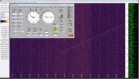
A resume from the feed by Edgar Kaiser with his 1 meter dish, clearly showing the deorbit burn, avoid colision burn (small one) and burn to get orbit again (last big one).
|
Posted by: Tom Tamlyn May 14 2021, 10:33 PM
Fabulous video of the burn just played on the live feed.
Posted by: nprev May 14 2021, 10:37 PM
You watching the RocketGyan feed, Tom, or do you have another?
Posted by: kenny May 14 2021, 10:38 PM
what web site was that, Tom?
If you mean Rocket Gyan's live feed, he was only showing an old video of the initial Tianwen Mars orbit insertion burn.
Posted by: Tom Tamlyn May 14 2021, 10:49 PM
Nick, it was the RocketGyan feed at the link posted by Huguet here:http://www.unmannedspaceflight.com/index.php?s=&showtopic=8627&view=findpost&p=252215
I hadn't been watching much at all, but a few minutes ago tuned in just in time to catch the video. You could see the spacecraft wobble under the influence of the rocket thrust.
Kenny: Ah, thanks, hadn't been listening closely so didn't realize it was the orbit insertion burn. Sorry about gushing over such OLD NEWS. 

Posted by: Explorer1 May 14 2021, 11:14 PM
Perhaps there will be comparable imagery of the lander separation.
Should have landed by now; waiting for the signal to get to Earth....
Posted by: kenny May 14 2021, 11:43 PM
Rocket Gyan livestream is quoting Chinese commentators stating successful landing, without details yet.
Posted by: kenny May 14 2021, 11:55 PM
Several rumours of a successful landing on Weibo, including one from an apparent insider to the mission.
Posted by: Huguet May 15 2021, 12:12 AM
I just couldn't get any feeder after Mars go off sight from Edgar Kaiser and AMSAT in Germany.... so i didn't see the maneuvers to image the landing... I think its time to find or put a dish on Americas to this amateur purpose of video streaming huge events like this one.... and it will became more and more common.
Posted by: Huguet May 15 2021, 12:16 AM
Official source saying landing nominal.
https://twitter.com/AJ_FI/status/1393358422700183552
|
|
Posted by: nprev May 15 2021, 12:39 AM
CNSA just tweeted #Mars!!!
Posted by: Hungry4info May 15 2021, 12:43 AM
CGTN:
#BREAKING China's Tianwen-1 probe lands on #Mars
https://twitter.com/CGTNOfficial/status/1393365096609435648
And also from Xinhua.
https://m.weibo.cn/detail/4637036026006686
Posted by: nprev May 15 2021, 12:47 AM
Congratulations to CNSA on this achievement!
Posted by: Explorer1 May 15 2021, 01:10 AM
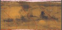
Apparently: 109.7 E, 25.1 N; (top middle of this map: https://en.wikipedia.org/wiki/Amenthes_quadrangle#/media/File:USGS-Mars-MC-14-AmenthesRegion-mola.png )
A bit North of the crater called Bluff....
Posted by: Hungry4info May 15 2021, 01:56 AM
From https://twitter.com/Cosmic_Penguin/status/1393382844131471363.
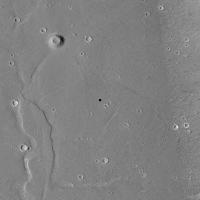
Posted by: volcanopele May 15 2021, 01:57 AM
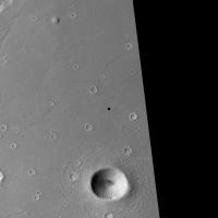
|
CTX image of the landing site. scale is 5.7 m/pixel. The large crater at bottom is 1.8 km across.
Posted by: Steve5304 May 15 2021, 02:30 AM
WoW!!
Congrats to the Peoples Republic of China
What an amazing achievement for such a new space program!
I hope we start getting Chinese posters!
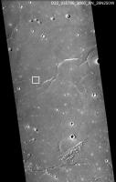
Posted by: Phil Stooke May 15 2021, 07:32 AM
The coordinates have been moved a bit, to 25.1 N, 109.9 E. That moves it out of the CTX image volcanopele posted and puts it about here:
|
The hills seen in the first orbital image are at lower right.
Phil
Posted by: kenny May 15 2021, 07:58 AM
Chinese news media are reporting "nine minutes of terror" during the landing, so two more than the usual American seven minutes!
The official landing time from CGTN was 23:18 UTC (GMT) so 7 minutes later than was being predicted by Chinese sources before the descent.
The whole craft (both orbiter and lander) started descending from orbit at about 17:00 UTC and entered the long descent trajectory. The landing module, consisting of the lander and the rover, separated from the orbiter after 3 hours at about 20:00 UTC according to the CNSA. Then, 30 minutes later, so about 20:30 UTC, the orbiter fired its engine to leave the decent trajectory (which it was also now on, temporarily, to drop off the lander) and returned to a safe orbit. After being dropped off the lander had a 3-hour voyage to entry interface. These announced times seem to be approximate.
I believe this is a new technique for Martian atmospheric entry, but was previously used by Galileo at Jupiter and Cassini at Titan.
Posted by: kenny May 15 2021, 04:42 PM
Xinhua News Agency has reported more details of the landing. No pictures as yet.
It took ground controllers more than an hour to establish the success of the pre-programmed landing. They had to wait for the rover to autonomously unfold its solar panels and antenna to send the signals after landing, and there was a time delay of more than 17 minutes due to the 320-million-km distance between Earth and Mars.
"The Mars landing of the Tianwen-1 mission has been a total success," Zhang Kejian, head of the CNSA, announced at the Beijing Aerospace Control Center.
It will take a further 7 to 8 days for the rover to detect the surrounding environment and conduct self checks before moving down from the lander to the Martian surface.
http://www.xinhuanet.com/english/2021-05/15/c_139948092.htm
Posted by: ollopa May 15 2021, 07:49 PM
It took ground controllers more than an hour to establish the success of the pre-programmed landing.
http://www.xinhuanet.com/english/2021-05/15/c_139948092.htm
Is there someone with some insight into the likely comms opportunities? For instance, I have seen speculation that on May 17 Zhurong will communicate with Tianwen-1 via ESA MarsExpress. I would have assumed that Tianwen-1 is over the horizon *much* longer than lower-orbit assets. Am I missing something? Is someone running the numbers?
Posted by: Huguet May 15 2021, 08:29 PM
https://mobile.twitter.com/df2mz/status/1393617519257268225
"This screen shot from CCTV seems to show that the Zhurong rover already communicated with Earth, opened its solar panels and downloaded some data." Edgar Kaiser
"rover landed still; started to communicate with earth; communication finished; rover unlocked/lifted up; solar wings opened; obiter adjusted position . Data downloaded in last 3 lines"

|
Posted by: rlorenz May 15 2021, 09:02 PM
New for Mars orbiters, perhaps. But Beagle 2 was delivered this way on Mars Express' hyperbolic approach
Posted by: Hungry4info May 15 2021, 09:08 PM
Some rough translations of the screenshot http://www.unmannedspaceflight.com/index.php?s=&showtopic=8627&view=findpost&p=252274... I think. Feel free to improve upon them with the times and copyable text.
8:01:24 火星车静态定姿 = Putting the rover in the proper attitude.
8:14:39 火星车对地通信开始 = Start of rover-to-ground comm.
8:32:04 火星车对地通信结束 = End of rover-to-ground comm.
8:38:04 火星车脱插分离,车体抬升 = Rover separation (from lander?) and body lifted.
8:59:04 火星车太阳翼展平 = Rover solar wing deployed.
9:48:39 环绕器-Z对日姿态调轨开始 = Orbiter Z-axis starts moving toward the sun.
12:00:39 固连遥测探头数据点播下传 = On-demand? telemetry download?
12:29:39 近距离遥测探头数据点播下传 = Short-range telemetry download?
13:15:39 降轨,两器分离数据点播下传 = Decrease orbit, separate the two devices? and download data on demand?
Posted by: tolis May 15 2021, 09:33 PM
"This screen shot from CCTV seems to show that the Zhurong rover already communicated with Earth, opened its solar panels and downloaded some data." Edgar Kaiser
"rover landed still; started to communicate with earth; communication finished; rover unlocked/lifted up; solar wings opened; obiter adjusted position . Data downloaded in last 3 lines"
Perhaps I am reaching, but is that a picture of a rock up on that screenshot?

Posted by: Huguet May 15 2021, 09:38 PM
Mabe they are working with some visual data. But they didn't get it right yet. Hard to wait for the images...
Posted by: Hungry4info May 15 2021, 09:44 PM
It looks like there's some sort of reflecting going on somewhere creating two image planes here -- one being the reflection of the screen in the glass(?) and the other being whatever is behind it. For some reason I can't quite make sense of what's going on. Just below the rock-like shape, there's this white jagged line. Is that a graphical representation of a radio signal? A reflected bit of light from somewhere? I'm not sure which is the original screen (the white line or the rock-like shape) and which is a reflection of something unrelated.
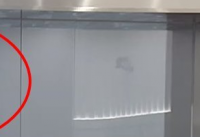
|
Posted by: djellison May 15 2021, 11:11 PM
Both Viking Landers were also deployed from orbit around Mars, like Tianwan - but I think what's unique here, and is more similar to ExoMars-TGO with Schiaparelli, Mars Express with Beagle 2, Galileo and Cassini Huygens compared to Viking - is that in those 4, the 'parent' spacecraft put itself on a collision course before deploying the lander and then doing a divert maneuver. In the case of Viking 1 and 2 - the landers themselves did their own deorbit burn to being entry into the atmosphere.
I think the only unique corner of all those boxes to be ticked yesterday is a parent spacecraft already in orbit putting itself into a trajectory for landing before deploying the lander and then doing a divert maneuver.
Phew.
Posted by: Huguet May 15 2021, 11:12 PM
Some equalization. First part of the screen seens to have a mars on it. Lest part the strange object and the graphic.

|
Posted by: serpens May 16 2021, 01:48 AM
I wish the Chinese rover the same solar panel cleaning events and longevity as Spirit and Opportunity. Hopefully there will be the same openness with respect to image release.
Posted by: marsophile May 16 2021, 03:10 AM
I wish the same, but the rover is substantially further north (~25 degrees). I fear it may have more trouble surviving the winter.
cos(2 * 10 degrees) = 0.940
cos(2 * 25 degrees) = 0.643
Posted by: vikingmars May 16 2021, 05:36 AM
Yes : the Chinese said that all images will be availalble for public release. And CNES and ESA will have also an access to them
Posted by: Huguet May 16 2021, 10:41 AM
"Accroding to xinhua, tiawen is scheduled to do a orbit change at the upcoming periapsis pass. From a 2 day orbit to a 1/3 day orbit."
Tianwen-1 has already changed its orbit, now it appears to be a 1 day orbit, but probably will be changed again for closers and fast ones.
https://mobile.twitter.com/df2mz/status/1393857334955450370
https://mobile.twitter.com/pyr0bee/status/1393854471529123840
Posted by: Huguet May 16 2021, 02:06 PM
They have been very open to Chang'e raw data. The Chinese understand that the biggest enemy of Space Exploration is politics, so they are leting their space program run very freely. I think thats why they are geting so much success.
I expect then to be open with the Tianwen-1 data, like they did with the chang missions.
Posted by: bobik May 16 2021, 03:50 PM
https://www.cnbeta.com/articles/science/1128229.htm they made some precautions, they applied a special microstructure coating on the solar panels to reduce friction between dust particles and surface, and the two side panels can be tilted by electric motors to remove accumulated dust by gravity and improve sun illumination.
Posted by: Toma B May 16 2021, 06:40 PM
Thank you for that link Bobik. That was very informative.
I recently came across this poster. I don't know if it is genuine or not but what surprised me is that microphone under the mast cameras. I don't recall seeing a microphone in any Zhurong instruments list... anyway, here is that poster slightly modified in Topaz Gigapixel.

|
Posted by: Hungry4info May 16 2021, 07:28 PM
From https://twitter.com/zzbar/status/1393986638188105729:
An orbit adjustment will be performed today to lower period to 8 hours. Also Zhurong is solar powered, not RTG, the window of opportunities to transmit images is much narrower. So far only sensor and state data were transmitted. Dont expect pictures till mid week.
Posted by: Greenish May 16 2021, 08:20 PM
Agreed, bobik, thank you for this article which has a bunch of details I hadn't seen (though I'm realizing I have a lot to catch up on, so it's probably not new to everyone). In particular it points to a bunch of innovations motivated by lessons from prior US rovers and the Chang'e missions, among them:
(1) answers the question from upthread about the two circular features in the center of the rover top surface:QUOTEIn addition to the solar panels, there are two circular films on the body of the rover, which look like a greenhouse. It is indeed a "greenhouse" for the rover, but there are no plant seeds in it, but phase change insulation materials....
...
If the control scheme on the moon is copied, even if the wake-sleep process will not affect the rover, the cumbersome start-up, self-check, and adjustment procedures will also Take up a lot of time. Therefore, the rover is also working at night.
...
During the day, "Zhu Rong" thermal insulation material liquefies to absorb heat, and at night it solidifies and releases heat. This special feature allows Zhu Rong to maintain a constant body temperature even under drastic changes in the external environment temperature, so that the various components it carries can work more stably and for a longer period of time.
(2) also mentions the ability to turn the wheels sideways 90 degrees and (!) unlock the suspension joints, using the wheel motors to raise or lower itself and "creep" out of any situation where it gets stuck. - Edit: here is a paper by the cited author on the subject: https://www.sciencedirect.com/science/article/abs/pii/S0094114X1830171X - paywall but with graphical abstract
Posted by: Huguet May 16 2021, 09:04 PM
Don't know if other orbiters would help. I believe the orbit must pass near Zhurong to help. Thats why they are changing and lowering the tianwen-1 orbit.
I have a big doubt.. If the navigation is based on Photogrammetry, using a heavy pack of images at each processing. How will they help that from earth with this kind of dificult to receive the data....
Posted by: Huguet May 16 2021, 10:30 PM
Following Space Exploration is a guide to a heart atack...
"China's Zhurong rover Mars EDL:
1) 9 minutes of something approximating terror
2) 18 minutes of light delay/ontological deliberation
3) 90 minutes of info blackout & confusion
4) Official success
5) 2 Days & counting of so where are the photos?"
Andrew Jones
https://twitter.com/AJ_FI/status/1394052879510605825
Posted by: Explorer1 May 16 2021, 10:46 PM
No chance other non-NASA spacecraft can act as relays? MOM, Hope, etc? If not, this is going to be a slow ground mission (Galileo but one planet inward!)
Posted by: Huguet May 16 2021, 11:13 PM
A Image that tells a lot, we only see a good chang'e-3, chang'e-4 nominal, chang'e-5 nominal, Tianwen-1 nominal till now... But a image of Tianwen-1 chief designer Zhang Rongqiao in tears after the succesfull landing tell a lot about what we can't see....
http://www.xinhuanet.com/english/2021-05/16/c_139949426.htm

|
Posted by: djellison May 16 2021, 11:51 PM
Neither MOM nor Hope have relay hardware.
Exomars TGO does - but it's not clear to me that it's compatible with Zhurong given that it's an Electra radio supplied by NASA-JPL.
In early operations - Spirit and Opportunity survived with just MGS and Mars Odyssey. One could quite easily design a concept of operations that works with a single relay asset in a longer period elliptical orbit. Infact- depending on link budget and pass duration, you could get a huge amount of data back with a spacecraft in a more elliptical orbit. MAVEN and TGO return the lions share of data from MSL, for example.
Even if the orbiter were to fail for some reason - the size of the high gain antenna on this rover would suggest something around 1 - 20 kbps of direct to earth downlink if required - you could return a few tens of megabits per sol that way if necessary.
Galileo operated with around 0.1kbps of downlink. This is not going to be 'Galileo but one planet inward'.
Posted by: rlorenz May 17 2021, 02:52 AM
During the day, "Zhu Rong" thermal insulation material liquefies to absorb heat, and at night it solidifies and releases heat. This special feature allows Zhu Rong to maintain a constant body temperature even under drastic changes in the external environment temperature, so that the various components it carries can work more stably and for a longer period of time
IIRC Beagle 2 had a similar 'solar accumulator' feature. I suspect there's only a range of (small) vehicle sizes where they make sense. On the one hand it lets you store all the solar radiation as heat, so per unit area you are getting more joules into the system to tide you over the cold night. On the other hand, if you covered the same area with insulation and with solar cells, you'd only intercept 25% or so of the energy, but you'd be able to control it better as it's electricity in wires which you can switch easily. Above a certain size, that controllability is probably more important (rover overheating is often more of an issue than freezing..)
Posted by: Cosmic Penguin May 17 2021, 05:12 AM
Exomars TGO does - but it's not clear to me that it's compatible with Zhurong given that it's an Electra radio supplied by NASA-JPL.
In early operations - Spirit and Opportunity survived with just MGS and Mars Odyssey. One could quite easily design a concept of operations that works with a single relay asset in a longer period elliptical orbit. Infact- depending on link budget and pass duration, you could get a huge amount of data back with a spacecraft in a more elliptical orbit. MAVEN and TGO return the lions share of data from MSL, for example.
Even if the orbiter were to fail for some reason - the size of the high gain antenna on this rover would suggest something around 1 - 20 kbps of direct to earth downlink if required - you could return a few tens of megabits per sol that way if necessary.
Galileo operated with around 0.1kbps of downlink. This is not going to be 'Galileo but one planet inward'.
Mars Express will help on the relaying: https://twitter.com/esaoperations/status/1286233914814672899?s=21
In fact there are murmurs that MEX will make its first communication session with Zhurong later today: https://forum.nasaspaceflight.com/index.php?topic=35045.msg2238231#msg2238231
The orbiter probably has also made its orbit lowering burn to the main communications orbit a few hours ago, updates pending.
Posted by: marsophile May 17 2021, 05:46 AM
In early operations - Spirit and Opportunity survived with just MGS and Mars Odyssey.
...
Of course, Spirit and Opportunity did have Direct-To-Earth (DTE) via their high-gain and low-gain antennas. The DTE would presumably have been critical in working the Spirit anomaly.
Posted by: vikingmars May 17 2021, 07:04 AM
And remember that the two 1st images taken by Viking Lander 1 just after landing (Sol 0) and received 'live' on Earth weighted only 730 Ko alltogether (*) for transmission through a single orbiter (VO-1) which was also on a very elliptic orbit (32,800 by 1513 km).
The Chinese need a greater transmission capacity to return the hi-res color images they want : so, it will take more time for them to retrieve this much greater amount of data.

|
|
|
(*) This looks very primitive compared with today's technologies, but this imaging strategy worked very well (and the media were stunned by the results)

Posted by: Huguet May 17 2021, 11:56 AM
Together the next mars mission i would believe china will send a network infrastructure in another ship to orbit, land or both. First big problem is obvious the datalink beetween the two planets....
Posted by: nogal May 17 2021, 01:32 PM
I found the coordinates Phil mentions on this news site https://m.chinanews.com/wap/detail/zw/gn/2021/05-15/9477804.shtml

Contrast with this GE Mars snapshot of the site area to which I added the Tianwen-1/Zhurong location and uncertainty [+/- 0.05deg] bounding box.
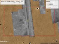
|
Fernando
PS: I intend to, in a future post, perhaps in the maps thread (hint, hint), cover the two CTX images I have added to GE's Global CTX overlay.
PPS: There aren't any HiRISE images of the area but a HiWish has been registered.
Posted by: djellison May 17 2021, 02:28 PM
I was talking about relay. I specifically mentioned the likely DTE performance later in the same post.
Posted by: Huguet May 17 2021, 02:35 PM
"#Tianwen1 now in new "relay" orbit with a Period of 8.2 h (2.927128 rev/d),"
"Peri height 260.990860 km. Next Apoapsis 12:50 UTC, next Periapsis at 16:56 UTC."
AMSAT-DL
https://twitter.com/amsatdl/status/1394271922402308100
Orbiter passing now 3 times a day at a distance of 261 km from the rover.
"Patience is required, suggested Zhang Yuhua, deputy chief commander of the Tianwen-1 Mars mission"
https://www.leonarddavid.com/china-mars-mission-data-relay-from-utopia-planitia/
Edgar Kaiser could see a full half orbit of Tianwen-1 without a break in sighting.

|
|
Posted by: marsophile May 17 2021, 05:23 PM
Can they even take any images until they stand up the rover?
Posted by: Steve G May 17 2021, 08:05 PM
It has been reported that the lander has cameras, so I assume so. How long the lander's cameras last after rover deployment is TBA, but I imagine it will be a very brief period.
Posted by: tolis May 17 2021, 08:15 PM
As we seem to be on standby waiting for the images, do we know anything about rock abundance on the landing site?
The VL2 site, also on Utopia though quite some distance away to the NE, looked awfully rocky to my non-expert eye.
Is VL2 a good analogue for the sort of terrain we should be expecting to see?
Posted by: Huguet May 17 2021, 08:38 PM
We can try so mosaic the images from the orbiter and try to predict wich craters ly near Zhurong...
Posted by: volcanopele May 17 2021, 08:46 PM
|
Using the updated landing location (25.1N, 109.9E), here's an estimate on the landing location using a pair of CTX images (D22_035786_2060_XN_26N250W and F04_037553_2068_XN_26N250W). Location could be a bit off due to the location available not being precise enough and due to this only using the raw spice location for one of the images. Still no HiRISE images of the site.
Posted by: Huguet May 17 2021, 08:50 PM
|
|
Using the updated landing location (25.1N, 109.9E), here's an estimate on the landing location using a pair of CTX images (D22_035786_2060_XN_26N250W and F04_037553_2068_XN_26N250W). Location could be a bit off due to the location available not being precise enough and due to this only using the raw spice location for one of the images. Still no HiRISE images of the site.
Do you have the stereo pair of it?
Posted by: ollopa May 17 2021, 09:19 PM
What are the white streaks which are everywhere in Utopia imagery? Sand, or frost?
Posted by: Hungry4info May 17 2021, 10:05 PM
From https://twitter.com/ea4gpz/status/1394405734742384640 showing Tianwen-1's new orbit.
|
Posted by: volcanopele May 17 2021, 10:18 PM
They look small sand dunes to me.
Posted by: scalbers May 18 2021, 12:49 AM
VL2 was near the crater Mie though I'm unsure if that directly contributed to the rocks we see. There is more discussion here:
http://www.planetary.brown.edu/pdfs/3555.pdf
The VL2 site, also on Utopia though quite some distance away to the NE, looked awfully rocky to my non-expert eye.
Is VL2 a good analogue for the sort of terrain we should be expecting to see?
Posted by: Phil Stooke May 18 2021, 01:42 AM
We know the area is much less rocky than VL2 - HiRISE makes that very clear (though HiRISE coverage doesn't yet reach the exact landing site). And for a rover that's good. No small rover could cope with the VL2 site. Mie's ejecta does reach the VL2 site (a large ejecta lobe is to the south) and probably contributes many of the rocks.
Phil
Posted by: vikingmars May 18 2021, 05:45 AM
Phil
Agree with you Phil. It's not because the Chinese land in 'Utopia' that the landscape will look the same like the one revealed by VL2
Utopia is a very vast plain with various geological units, and at the latitude of VL2 (48°N), it is mostly made of a permafrost (ice-rich soil) below a ~ 25 - 30 cm layer of dry sediments.
=>> My guess is that the Zhurong landing site at 25°N will be very flat with small rocks and pebbles (thus, much, much less rocky than VL2), and will look like the InSight landing site, but with some spaced-apart dunes and low-lying crater rims.
For sure, this site is the safest possible for testing landing technologies and a first try.
Posted by: nprev May 18 2021, 05:59 AM
Topic title changed to reflect successful landing and in anticipation of surface operations.
Posted by: Phil Stooke May 18 2021, 06:28 AM
I might also add that the Viking landing site team did not expect those rocks. They thought they were landing on a layer of sand which would cover any rocks, and they would not have gone to that site if they knew how rocky it was. The orbital images were far less satisfactory than for the Viking 1 site. We are so much better prepared for site selection today - superb images and thermal inertia data to reveal patches of rocks smaller than HiRISE can see. If The Chinese site selection people thought their site was anything like VL2 they would not try to land there.
Looking forward to the first pictures!
Phil
Posted by: Cosmic Penguin May 18 2021, 10:06 AM
|
|
The hills seen in the first orbital image are at lower right.
Phil
What's the theory behind those grooves (cracks?) and round shaped buttes in the general area? I've looked around the MRO HiRISE and CTX image catalogs and they seems to be interesting features to look into should the rover made that far.
Posted by: Huguet May 18 2021, 10:51 AM
I don't think the rover will go far, unless they stablish a better comunication with earth. I Believe the decision on which path to take will be done similar to the used for chang'e-4. It depends on images send to earth.
Posted by: Huguet May 18 2021, 12:32 PM
The first communication from Zhurong was only 2 bytes per second, direct to earth. Now It will use UHF communication and X-band passing through the relay, going to a 2.5 and 6.25 MB of data per day. Thats my understanding from this link on Weibo. So it would be impossible to get an image at the first days. But if they success on using the relay options we will got something soon.
If the information proceeds they have already downloaded less then 200 kB in 3 mars days... Thats why no image...
So,.. Zhurong has not yet used Tianwen-1.... I used google translator, so if anyone can get a better info from the pics or the text.
"最近很多人问为什么祝融号到现在依然没有图片回传?着陆两三天了都还没回传是不是有问题balabala,诶,这可别着急,下面就分析一下为什么直到现在都没有照片的原因,如图所示(资料来源@航天爱好者网 ),落火当天使用的是自主的直接对地通讯方式,这个对地通讯模式的传输速率仅仅为16bps,也就是一秒传输2个字节,在这种带宽下,仅仅只能判断探测器状态,极其难以实现图片回传,如果一张100KB的低清图片没有经过压缩的话,使用这个小水管回传需要大概14小时左右,这还是不考虑祝融号本身测控的所占用的带宽,但是,在三个火星日之后,也就是今天晚上呢,火星车会和在轨道上面的天问一号第一次尝试建立UHF通讯链路,每次持续8-10分钟,建立以后每天能够回传20Mbit(2.5MB)的数据,再之后每3天会建立一次X波段的通讯链路,这种通讯链路的每次通讯的数据就达到了50Mbit(6.25MB)的数据,所以,如果一切都顺利的话,今天晚上可能拿到祝融号的第一批大小约为2.5MB的数据,就让我们敬请期待这2.5MB小小的数据包里面有没有着陆后的照片吧。如果没有也不要灰心,再等几天,数据会陆续的传回来,相信早晚会看到我国第一张从火星表面发来的照片的!
@北斗_玉衡 @大英良心汉弗莱 @脱欧入亚卡菊轮"
https://m.weibo.cn/detail/4637909523366148#comment

|
|

|
Posted by: Huguet May 18 2021, 03:18 PM
Good compilation of Events from 2015 till now and upcoming (possible):
https://www.shymkent.info/space/chinese-spaceflight/tianwen-1-1st-flagship-mission-to-mars/
"Upcoming events
18th May 2021: First images of Mars rover Zhurong will be received as early as 18th May 2021 at 1am UTC (Sol 3). At this time the first data packages will received. But it is not clear if the first data packages have images of the martian surface inside or only telemetry or science data.
22nd May 2021: Chinas Mars rover Zhurong will roll down from the descent module to the martian ground (Sol 7).
27th May 2021: China likes selfies. Like the photo sessions of Yutu-1&2 with the Change-3&4 landers on the Moon also Zhurong will do a photo session between rover and the descent module (Sol 13).
28th May 2021: Science program will start on the surface on 28th of May(Sol 14). Zhurong will perform 90 days of science on the Mars. After 90 days they will slow down or stop the mission of the Mars rover. The Tianwen-1 orbiter will change its orbit again. The orbiter will enter a science & mapping orbit to inspect and to map the planet Mars."
Posted by: ollopa May 18 2021, 04:20 PM
What science is ahead for the Zhurong Rover in Utopia Planitia?
https://astronomycommunity.nature.com/posts/what-science-is-ahead-for-the-zhurong-rover-in-utopia-planitia
Posted by: djellison May 18 2021, 07:47 PM
Reading between the translation...
So far only 16bps on X Band DTE
They're expecting to return 20 Megabits through UHF daily starting on Sol 3 with a single 8-10 minute UHF Pass.
The 50 megabits per sol through DTE X-Band seems a little big.....if they can handle 10kbps DTE it's probably doable. Doing it every 3 days seems reasonable as well.
Posted by: Steve5304 May 18 2021, 09:55 PM
If the information proceeds they have already downloaded less then 200 kB in 3 mars days... Thats why no image...
So,.. Zhurong has not yet used Tianwen-1.... I used google translator, so if anyone can get a better info from the pics or the text.
"最近很多人问为什么祝融号到现在依然没有图片回传?着陆两三天了都还没回传是不是有问题balabala,诶,这可别着急,下面就分析一下为什么直到现在都没有照片的原因,如图所示(资料来源@航天爱好者网 ),落火当天使用的是自主的直接对地通讯方式,这个对地通讯模式的传输速率仅仅为16bps,也就是一秒传输2个字节,在这种带宽下,仅仅只能判断探测器状态,极其难以实现图片回传,如果一张100KB的低清图片没有经过压缩的话,使用这个小水管回传需要大概14小时左右,这还是不考虑祝融号本身测控的所占用的带宽,但是,在三个火星日之后,也就是今天晚上呢,火星车会和在轨道上面的天问一号第一次尝试建立UHF通讯链路,每次持续8-10分钟,建立以后每天能够回传20Mbit(2.5MB)的数据,再之后每3天会建立一次X波段的通讯链路,这种通讯链路的每次通讯的数据就达到了50Mbit(6.25MB)的数据,所以,如果一切都顺利的话,今天晚上可能拿到祝融号的第一批大小约为2.5MB的数据,就让我们敬请期待这2.5MB小小的数据包里面有没有着陆后的照片吧。如果没有也不要灰心,再等几天,数据会陆续的传回来,相信早晚会看到我国第一张从火星表面发来的照片的!
@北斗_玉衡 @大英良心汉弗莱 @脱欧入亚卡菊轮"
https://m.weibo.cn/detail/4637909523366148#comment
Be nice if NASA or ESA offered some bandwith. Its just data, im sure they could make it happen
Posted by: Explorer1 May 18 2021, 10:32 PM
There's a major piece of legislation forbidding cooperation between the US and China. Our forum's no politics rule means I can't get into details, but even if it didn't exist, there's the whole matter of trust that what is received on the ground is really accurate regarding what is happening at Mars, and without that trust, it's not viable. It is not an issue for ESA and NASA, but China is another matter. We can only hope that future missions do not suffer from Earth-based politics....
Posted by: djellison May 18 2021, 10:39 PM
NASA is legally prohibited from collaborating with China in any way.
ESA has already given ground station time for downlink and ranging/tracking to this mission and Mars Express will be conducting relay.
Posted by: Huguet May 19 2021, 12:05 AM
Tianwen-1 has stablished a orbit with a duration of exactly 1/3 martian day.
by Edgar Kaiser
https://mobile.twitter.com/df2mz/status/1394749129310580738
We got a relay!
"China's lunar exploration program posted on its official account on social media platform WeChat on Tuesday.
The orbiter has completed its fourth braking near Mars, entering the orbit for relay communication. Zhurong has established data link with Tianwen-1's orbiter and successfully transmitted data to Earth through it for the first time on Monday"
https://news.cgtn.com/news/2021-05-18/China-s-Zhurong-Mars-rover-sends-back-data-via-orbiter-10mXyj3r84M/index.html
Posted by: Phil Stooke May 19 2021, 01:01 AM
djellison: "NASA is legally prohibited from collaborating with China in any way."
I understand that the wording is to the effect that NASA has to have the approval of Congress (presumably via an oversight committee) before it can cooperate. Not that I am an expert. Cooperation on specific points might be permitted if approval could be obtained. Of course, that approval might be difficult to get.
Phil
Posted by: Cosmic Penguin May 19 2021, 04:47 AM
https://9ifly.spacety.com/forum.php?mod=redirect&goto=findpost&ptid=94560&pid=841341&fromuid=19646 that the 1st Mars surface photos from the Tianwen-1 lander/rover will be released in a few hours (possibly at the 7 pm news on state media CCTV, which would be after 11:00 UTC).
Posted by: vikingmars May 19 2021, 05:32 AM
Phil
Yes Phil ! This is true for cooperation on specific matters, like information storage and share at NSSDC which has been discussed already for their Moon missions but not yet implemented
Posted by: Huguet May 19 2021, 10:23 AM
They are so focused on Zhurong and Tianwen-1 that the Yutu-2 are not moving, its all stopped on the last lunar day to put all efforts on Zhurong. After Zhurong starts making its science procedures Yutu-2 will resume activities...
By Andrew Jones
https://twitter.com/AJ_FI/status/1394930830439591936
Posted by: Cosmic Penguin May 19 2021, 10:37 AM
https://mp.weixin.qq.com/s/UCsz3BgAogOpv7qP9fFczQ
|
|

|
|
Posted by: neo56 May 19 2021, 10:54 AM
Finally! Are the two gifs showing the release of heatshield, backshell or both?
Posted by: Cosmic Penguin May 19 2021, 10:56 AM
It's the complete lander separating from the orbiter.
Posted by: neo56 May 19 2021, 11:19 AM
OK thanks.
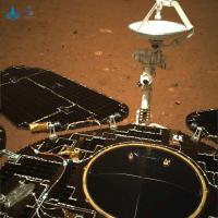
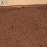
A rectified and sharpened version of the picture taken by the "Hazcam" of Zhurong rover.
https://flic.kr/p/2kZtssB
Posted by: Huguet May 19 2021, 11:29 AM
A rectified and sharpened version of the picture taken by the "Hazcam" of Zhurong rover.
Its a little more fish eye....
Posted by: kenny May 19 2021, 11:36 AM
For sure, this site is the safest possible for testing landing technologies and a first try.
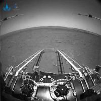
Good guess, VikingMars !
It's very flat, at least in the direction where we can see the horizon.
Most of the rocks that are showing appear to be embedded in dusty regolith.
Posted by: Huguet May 19 2021, 11:39 AM
Is this a crater? Far right, top.
Second image was with a compression on the green of 50% and 75% compression on the blue band, follow it with RGB manually equalized.

|

|

|
Posted by: Cosmic Penguin May 19 2021, 11:59 AM
Original sized photos, via CNSA: http://www.cnsa.gov.cn/n6759533/c6812021/content.html

|

|
Posted by: vikingmars May 19 2021, 12:11 PM
And CONGRATULATIONS for the Chinese for having landed their spacecraft on Mars with success at their first try 
This is a GREAT technological and human feat ! They deserve great tributes 
Posted by: MERovingian May 19 2021, 12:37 PM
BRAVO BRAVO BRAVO to the Chinese! What a great achievement! 
There are three rovers on Mars now... Wow!!
... Where are you, Rosalind Franklin... 
Posted by: Greenish May 19 2021, 12:52 PM
Thomas as usual quickly made a great image, but here's a few other re-mappings.

|

|
Congrats to the Chinese team.
(Edited - use higher-resolution sources per post upthread a bit)
Posted by: Huguet May 19 2021, 02:12 PM
Got any parameters for the calibration of the avoidance camera?
Posted by: kenny May 19 2021, 02:20 PM
Xiunhua News Agency has reported which cameras were used for the first two pictures.
1. The Black & White image was taken by an obstacle avoidance camera installed on front of the rover. As is obvious, it confirms that the rover's descent ramp on the lander has been extended to the surface.
2. The color image was taken by the navigation camera fitted to the rear of the rover. Used to confirm deployment of the rover's 4 articulated solar panels and antenna.
Posted by: Greenish May 19 2021, 02:49 PM
Nothing specific, no. Figured I'd look it up later, for now just tried a few things in Hugin that looked about right with the horizon and other lines...(FWIW used full-frame-equiv. focal length in 14-20mm range).
Posted by: vikingmars May 19 2021, 02:51 PM
=>> My guess is that the Zhurong landing site at 25°N will be very flat with small rocks and pebbles (thus, much, much less rocky than VL2), and will look like the InSight landing site, but with some spaced-apart dunes and low-lying crater rims
Good guess, VikingMars !
Thank you very much Kenny
Posted by: Huguet May 19 2021, 02:57 PM
It is possible to generate a terrain using the avoidance photos. If we have the right calibration. I will try to get this calibration using the yutu-2 avodance camera, mabe they are similar.
Posted by: Phil Stooke May 19 2021, 11:42 PM
I stretched the area near the horizon to try to interpret the surface features a bit better. From the illumination I think the view is roughly to the south (may be SE or SW). A few of those bright drifts are visible beyond a rocky area. Not enough in this to locate it yet.
Phil

|
Posted by: vikingmars May 20 2021, 12:48 AM
Thank you Phil. Also, maybe that MRO has already imaged Zhurong on its landing site
Posted by: tolis May 20 2021, 09:42 AM
It's very flat, at least in the direction where we can see the horizon.
Most of the rocks that are showing appear to be embedded in dusty regolith.
On the b&w image there is a dark band just in front of the bright patches near the horizon that appears to be lined with rocky debris,
especially on the right hand side. Wonder if are looking at a subdued crater rim here.
Posted by: Phil Stooke May 21 2021, 11:36 PM
This Youtube video is a presentation in Chinese about site selection work done at Hong Kong Polytechnic University. There are some interesting pictures, one showing ellipses on a hazard map (I think).
Phil
https://www.youtube.com/watch?v=WEmjzReJ-IA
Posted by: Phil Stooke May 22 2021, 12:13 AM
The locations of the ellipses in that presentation. The actual landing was in the left-hand ellipse.
Phil

|
Posted by: Cosmic Penguin May 22 2021, 06:18 AM
The rover has rolled off the lander's deck onto Martian surface earlier today at 02:40 UTC.
https://mp.weixin.qq.com/s/7vrZxv-axGi0dRS665IuxA

|

|
Posted by: Phil Stooke May 22 2021, 06:44 AM
Thank you, Cosmic Penguin - it's very good to see you here.
The view from half way down the ramp is interesting - looking approximately north, I think, and there is some significant relief on the horizon. Here's a stretched version of the image to show it with some exaggeration, making distant features a bit easier to interpret.
|
Phil
Posted by: Cosmic Penguin May 22 2021, 08:26 AM
Sequence of additional photos taken by all 4 HazCams (one pair each at the front and back) of the rover driving off the ramps, via CCTV:
https://h5.video.weibo.com/show/1034:4639686283690111
EDIT - https://twitter.com/AJ_FI/status/1396020280301170691
Posted by: kenny May 22 2021, 09:09 AM
Here's the accompanying graphic showing the layout of the deployment...

|
Posted by: kenny May 22 2021, 09:20 AM
The national flag is clearly seen on the graphic. It appears to be a little fabric flag, unrolled. You can see it from different angles in the two rearward-looking photos from the rover after deployment.
Posted by: Roman Tkachenko May 22 2021, 10:28 AM
Stereo view

Posted by: neo56 May 22 2021, 11:41 AM
That's great Zhurong rover made it to the ground!
I made this montage yesterday, actually I can now update it with a picture with Zhurong wheels on the martian surface.
4 pictures taken by 4 robots the same day (15 May) on Mars.
https://flic.kr/p/2kZLtdi
Posted by: Hungry4info May 22 2021, 03:03 PM
I haven't seen these images posted in this quality before (admittedly, it doesn't look like the original quality). It seems to alternate back-and-forth between left and right rear HazCams.
(I've done everything I know how to try to organize this by file name, but that didn't work, and I can't seem to get the formatting right through insert-in-post, so you're left with this monstrosity ... )

|

|

|

|

|

|
Posted by: Hungry4info May 22 2021, 03:35 PM
From https://m.weibo.cn/status/4639722288714588 are some higher-quality rear HazCam and front HazCam left-right sets. Any idea what the dark (apparently-)linear features are to either side of the rear hazcam images are? They're about half-way up the image and on the far edges of both. I originally thought it might be some out-of-focus instrumentation on the rover, but they don't show up in other rear hazcam images, and the left-right set doesn't seem to show the sort of displacement one would expect if they weren't actual surface features on the ground.

|

|
Posted by: Hungry4info May 22 2021, 04:06 PM
Finally I found some higher-quality versions of the forward hazcam(s).

|

|

|

|

|

|
Posted by: fredk May 22 2021, 04:32 PM
Thanks for posting these.
They appear to be real features on the ground - compare the one on the right with the dark rock near its left tip. In other frames they should be out of the frame due to the change in perspective.
I'm guessing they're blast features from the landing.
Posted by: neo56 May 22 2021, 05:05 PM
Animation of Zhurong roving down the ramp as seen by "Hazcam" left.

|
And the same as seen by "Hazcam" right.

|
Posted by: Huguet May 22 2021, 07:13 PM
And more one colored... not good ... but has colors....

|
Posted by: neo56 May 22 2021, 07:46 PM
I also corrected the distorsion to flatten the horizon.
Animation from left "Hazcam":

|
And animation from right "Hazcam":

|
Posted by: PDP8E May 22 2021, 08:37 PM
It would be nice to have an early or late day image to determine the ramp orientation (N, S, E, W)
My guess is South (season, local noon-ish, latitude, shadows)
???
Posted by: marsophile May 22 2021, 11:31 PM
Of course it won't happen, but for my amusement, I've been imagining the possibility of a helicopter trip by Ingenuity to the location of the Zhurong rover. This Nature article
https://www.nature.com/articles/d41586-021-01301-7?utm_medium=affiliate&utm_source=commission_junction&utm_campaign=3_nsn6445_deeplink_PID100044684&utm_content=deeplink
suggests they are less than 1000 km apart. It seems Ingenuity can fly at a speed of 15 km/hr. Assuming it flies ~3 hours per day, it seems the trip would take less than a month. Vive le difference between ground speed and air speed!
[EDIT] The distance is closer to 1860 km, according to a lat/lon calculator, so it would take twice as long. Less amusing.
Posted by: nprev May 23 2021, 02:02 AM
So I can't help noticing that the landing leg facing the ramp is...well...fuzzy. Insulation? Doesn't seem to be present on the leg to the right.
Also, the pad for that leg seems to be almost precariously perched on one or more rocks. Obviously--and fortunately--it was seated well enough to work for offload.
Posted by: Phil Stooke May 23 2021, 02:15 AM
PDP8E: "My guess is South (season, local noon-ish, latitude, shadows)"
That was my guess as well. Approximately south.
Phil
Posted by: Steve G May 23 2021, 03:23 AM
Unlike the American landers, Zhurong's lander used a single, lunar module-like engine. I imagine the non-disbursed plume created one of the dustiest landing ever. This may account for the lander's ragged-looking appearance.
Posted by: Greenish May 23 2021, 05:41 AM
Here's some approximately reprojected horizon crops. I think the field of view is about 120 deg, but can't really be sure.
Fhaz (south?)
|
|
Rhaz (north?)
|
|
My guess is southeast part of the circle I drew on the map thread.
Posted by: rlorenz May 23 2021, 03:19 PM
Seems like there is less scour under the Zhurong lander than either InSight or Phoenix (which had clustered nozzles).
I do notice two dark patches, roughly equidistant either side of the lander, and wondered if they were related to plume impingement from something
Seems like there is some ragged-looking insulation on the landing legs. (In fact thermal shielding to protect the Apollo landing gear from plume heating was an issue late in that design)
Posted by: Phil Stooke May 23 2021, 06:06 PM
Greenish made those nice horizon images, and here I have reprojected them to focus on the distant features with the hope of identifying something on the CTX images. Not very easy! I thought the Fhaz view was to the south (as shown here) with roughly noon illumination, bur reprojecting like this makes me feel that the view might be oriented more towards the SE with mid-morning illumination. The distant bright spots are obviously the bright dunes or ripples which show up in the CTX image, and there is a little bit of relief on the horizon, but no luck yet finding a match. A full Navcam panorama will help a lot.
Phil

|
Posted by: Huguet May 24 2021, 10:52 AM
"Upcoming events
18th May 2021: First images (Done)
22nd May 2021: Chinas Mars rover Zhurong will roll down (Done).
27th May 2021: China likes selfies. Like the photo sessions of Yutu-1&2 with the Change-3&4 landers on the Moon also Zhurong will do a photo session between rover and the descent module (Sol 13)." I didn't saw yet any camera on the lander.
Posted by: Roman Tkachenko May 24 2021, 12:11 PM

|
Posted by: neo56 May 24 2021, 01:12 PM
Nicely done Roman! It gives relief to the seemingly two bright dunes.
As we wait new color pictures taken by Zhurong and its landing platform, here is a colorization of one of the Hazcam pics.
Colors on the platform have been added on the basis of videos posted on chinese networks https://www.bilibili.com/video/BV1eh411v7zF?p=1&share_medium=iphone&share_plat=ios&share_source=COPY&share_tag=s_i×tamp=1621678834&unique_k=rcOIxx.
https://flic.kr/p/2m1qGJn
Posted by: Huguet May 24 2021, 01:49 PM
|
|
|
|
|
|
Posted by: Greenish May 24 2021, 04:16 PM
Roman, that is really well done!
Does anyone have a source or more info on the physical dimensions of the rover (and landing platform)? I have found a few notes about the rover's 1.85m height - assume that's to top of mast on level ground. I've seen various renderings but no few actual dimensioned drawings or 3-views I could scale stuff from.
In particular at the moment I'm interested in height off ground of the images taken so far, including hazcams and the images before the rover "stood up" and rolled down the platform.
(Edit )
I have now found one view; source: http://www.eppcgs.org/fileDQYXXWL/journal/article/dqyxxwl/2020/4/PDF/zhoubin-F.pdf. With this and other images (such as hi-res press rendering https://static01.nyt.com/images/2021/05/14/science/14CHINAMARS1/14CHINAMARS1-mediumSquareAt3X.jpg)I estimate the obstacle avoidance cameras as ~700-750mm above nominal ground level.
Would of course welcome more resources.

|
Posted by: neo56 May 24 2021, 07:08 PM
What do you mean by « atmospheric particles »? If youre referring to molecules in the atmosphere, then thats not absorption but scattering. Rayleigh scattering is proportional to 1/(lambda^4), hence shorter wavelength radiations are more scattered that longer wavelength radiations.
Posted by: Huguet May 24 2021, 07:24 PM
Posted by: Greenish May 24 2021, 08:07 PM
Here is a re-projection with labeled approximate horizontal distance, measured from the ground point under the front obstacle avoidance cam.

|
Note: the oddly-offset grid is a bit of a hack, it's snipped and overlaid from the previewer in Hugin where I did the reprojection. Distance values are based on many assumptions and a few guesses (see caption on image... OK the whole thing is a hack, but I was curious.) Since the GPR antenna rods are about 1.3 m long, angled ~16 deg up, the math doesn't seem way off, at least up close.
Posted by: Hungry4info May 24 2021, 09:33 PM
While we're waiting on new information, why are the "yardangs"/dunes here in Utopia Planitia bright, while in Gale crater the sand dunes are dark?
Posted by: Phil Stooke May 25 2021, 12:42 AM
The big dunes in Gale (Bagnold Dune Field etc.) and patches of sand caught in hollows are dark - probably because they are composed of basaltic grains. There are also many smaller dust drifts, especially earlier in the mission, such as Rocknest, which are finer material largely consisting of the typical bright reddish martian dust. Wind sorts the coarser and finer particles into separate structures rather than mixing them together. The Utopia region may lack sources for the darker material, but the brighter stuff is distributed planet-wide. Also look at Endeavour crater where Opportunity saw dark dunes inside Endeavour and lots of small bright drifts at the foot of the crater wall and elsewhere.
Phil
Posted by: Huguet May 25 2021, 11:02 AM
With success like Chang'e-4, chang'e-5 and Tianwen, im thinking why the countries don't exponentialize their space program, just sending others clone spaceships from success cases, to other moons and terrain bodies. I believe this goes within the idea behind chinese space program and SpaceX Falcon9 and StarShip, We just have so many places to land on the solar system, so much to learn, and a generation human life spam so small... Its time to use all of this to make a paradigm shift.
Posted by: alan May 25 2021, 06:13 PM
Is Zhurong using the rocker-bogie system from MER? Is that patent expired?
Posted by: Phil Stooke May 25 2021, 08:38 PM
It is using a vastly improved version of that system. The wheels can all turn 90 degrees so they can drive sideways to avoid an obstacle, and each wheel (or the 4 outer ones) can be lifted independently to step out of traps like Troy and Purgatory of MER fame.
Phil
Posted by: JRehling May 25 2021, 11:45 PM
This is a very general question and not much about Zhurong. However, as I've noted on threads here over 10 years ago, the value of space exploration is not treated like a commercial good where the more we get of it, the better off we are. We can try to reverse-engineer based on decision making what the value of it is, and it appears to be about national or institutional prestige, technological development, and a kind of global goodwill, and none of those things operate (in contrast to, say, gold mines) in a way that X times the investment results in X times the payoff.
Posted by: nprev May 25 2021, 11:55 PM
[Admin mode]: It is indeed very general and not much about Zhurong. Understand the tendency to drift a bit due to the slow pace of information release from this mission, but nevertheless let's please stay on topic. [/admin]
Posted by: Huguet May 26 2021, 09:40 AM
Twin engineering version on video and images of what i think is the mars version, but the two rovers on the pics are not identical. Have add a image graphical of Zhurong, but found without credit, so, not really trust it.
https://www.bilibili.com/video/BV1eh411v7zF?p=1&share_medium=iphone&share_plat=ios&share_source=COPY&share_tag=s_i×tamp=1621678834&unique_k=rcOIxx

|

|

|

|
Posted by: Pando May 27 2021, 10:59 PM
That thing looks huge in the first two pics.
Posted by: Huguet May 28 2021, 01:31 PM
The low gravity efect on the equipments construction is interesting... so small wheels to a huge equipment...
Zhurong has a huge,.. i mean, a HUGE magnetometer with it. We know very little about Mars magnetic Field and i think one of the top prioritys of Zhurong/Tianwen-1 is to chang(e) it. Decisive to navigate, to farm, to build habitats, etc, etc, etc....

|

|

|
Posted by: JRehling May 28 2021, 07:55 PM
The magnetometer is for studying any possible tiny, local magnetic fields in order to study the history of Mars's past magnetic field. There is no global magnetic field on Mars and I've never read anything to suggest that the tiny local fields would have any relationship to future exploration or have any engineering ramifications.
Posted by: Huguet May 28 2021, 08:23 PM
Posted by: Phil Stooke May 28 2021, 10:24 PM
The Moon has no global field and an array of scattered magnetic anomalies, but surface magnetometers have been used at Apollo sites and on Lunokhod 2 and I think they show plenty that would not be observed from orbit (I know nothing about the details of that work). It's reasonable to assume that a surface magnetometer traverse would at least have the potential to reveal something of scientific interest on Mars. So it's worth a look.
As for being huge, I think the huge magnetometer would be on the orbiter, not on Zhurong - the rover has a small one. The orbiter just deployed its magnetometer boom.
Phil
Posted by: Huguet May 29 2021, 12:36 AM
https://twitter.com/jackzhuanglia/status/1397835897614356481
http://www.eppcgs.org/article/doi/10.26464/epp2020058?pageType=en

|
Posted by: mcaplinger May 29 2021, 12:55 AM
On the contrary, we know a lot about the global magnetic field from MGS and Maven. See https://agupubs.onlinelibrary.wiley.com/doi/full/10.1029/2018JE005854 for example.
Posted by: rlorenz May 29 2021, 02:25 AM
There are a variety of reasons for putting a given payload on a mission
1. because it answers big important scientific questions
2. because there's a scientific constituency for making the measurements anyway, regardless of objective importance
3. because it's cheap and easy to accommodate
4. technology demonstration
5. public outreach
A magnetometer on an airplane or perhaps a really low orbiter at Mars might do (1) [MGS most profound findings were during its aerobraking phase when the low altitude brought higher sensitivity to surface fields and a higher spatial resolution]. But there has been magnetometry on Phobos-2, MGS and Maven, as well as on InSight, and Mariner 4, so the bar for high-impact discovery with an orbiter magnetometer at Mars is pretty high..
Space physics measurements on planetary missions (IMHO) benefit a lot from (2), a sort of inherited entitlement from the 1950s and 1960s. There's a community that's ready to build the instruments, they'll write papers on the data, even if the low-hanging fruit in terms of actual wide-impact discoveries have already been picked in previous missions.
Papers get written, the mission and its political advocates win, the scientists win. Even if the broader community and the public doesnt care...
[there is of course debate about whether a dynamo field protects a planet from water loss, which could be a 'big picture' consideration, but I think that's more a modeling issue than a need-more-data issue..IMHO]
A magnetometer on a rover could be interesting, if it traverses over some area with lava tubes or lots of iron meteorites or something. But that's a scientific gamble. The magnitude of the surface field is interesting (in combination with orbital data) to define the depth or thickness of a magnetized deposit, but it's basically a single number at a single site, so that's a pretty lean return on investment (and sure, the space physics crowd will do simultaneous orbital/landed measurements over long periods, and that's cool, and they'll write papers, and maybe there'll be interesting magnetotelluric sounding results, but that work isnt a strong enough motivation for a mission in the first place, only as an add-on.)
Which brings us to (3). Magnetometers themselves are not demanding instruments, but if you need a boom to get away from spacecraft fields that assessment changes. But if you have a boom design already for an orbiter (Double Star?) then maybe it's not a big add.
Mangalyaan / MOM was unashamedly driven by considerations 2/3/4. Tianwen / Zhurong is similar, but with a bit more possibility of (1) : for in-situ missions, you can make exciting new discoveries even with 'old' instrumentation, purely by virtue of being in a new environment. The combination of patterned ground and possible mud volcanos in Utopia is quite interesting, especially with the ground penetrating radar on Zhurong.....
Posted by: Steve G Jun 1 2021, 05:08 PM
Andrew Jones, the go-to guy on Chinese spaceflight, is even wondering where the new pictures are.
https://twitter.com/AJ_FI/status/1399342843093827584
Posted by: Huguet Jun 2 2021, 02:35 PM
My guess is Zhurong has made 11.7 m on Mars already, by what we got. Including going out of the lander .

|

|
Posted by: vikingmars Jun 3 2021, 09:11 AM
https://twitter.com/AJ_FI/status/1399342843093827584
Or, more simply, because they have a breakdown on the lander or on the orbiter and they are not willing to disclose it
Posted by: Steve G Jun 3 2021, 11:47 AM
I asked through a tweet to Andrew if some kind of damage might be the cause and he speculated that it's due to limited communication resources, but you have to start wondering at this stage if there are some issues.
Posted by: vikingmars Jun 3 2021, 12:37 PM
Yes this could be due to limited communication resources, but it is to be noted that, in 1976:
- Viking Lander 1 transmitted successfully a lot of daily data through a single orbiter (VO-1) during the first weeks of its mission before the arrival of VO-2 (August 7, 1976);
- VO-1 was also on a very elliptical orbit (32,800 x 1513 km), much like the Tianwen 1 Orbiter, and thus, JPL had to deal with short communication windows (like the Chinese today).
=>> Knowing that technologies had evolved a lot since 1976, this is why I pointed that the scarcity of images might be due to a component or communication failure they have to fix
Posted by: Phil Stooke Jun 3 2021, 03:12 PM
Just a few minutes before I posted this MRO flew close to Zhurong - if not close enough to image it, at least on an adjacent orbit it might have been. Just holding on to the hope that we will get a HiRISE image soon!
Phil

|
Posted by: nprev Jun 3 2021, 08:06 PM
I would caution everyone to avoid random and frankly counterproductive speculation at this point. I know everyone's used to NASA's way of doing things...but CNSA is not NASA.
We'll see what we see when we see it. That's the bottom line.
Posted by: Huguet Jun 4 2021, 03:22 PM
"The slow progress of the rover was due to the limited understanding of the Martian environment, so a relatively conservative working mode was specially designed," Jia Yang.
https://www.reuters.com/lifestyle/science/china-says-martian-rover-takes-first-drive-surface-red-planet-2021-05-22/
Posted by: Huguet Jun 4 2021, 04:38 PM
|
|
My Guess by now is a 1.5 m high mount with a -1.0 hollow at it side, 40 meter ahead of the lander. It is the white high mount (the middle one of the 3 visible mounds) and the depression near it (left side). The right mount is 30 meters apart from the middle one, and the left one i can't position it with my actual camera parameters, it is giving 3300 m with lot of imprecision...
The 3d of the mount look like the ones seen on the remote pics Tianwen-1 has got, exactly like it, the problem is that it is a pattern, resembling a inverted Nike symbol.

|

|

|

|

|
Posted by: Steve G Jun 4 2021, 05:43 PM
See twitter from Andrew Jones. New pics should be coming in shortly.
https://twitter.com/AJ_FI/status/1400767820212883463
Posted by: vikingmars Jun 5 2021, 07:23 AM
https://www.reuters.com/lifestyle/science/china-says-martian-rover-takes-first-drive-surface-red-planet-2021-05-22/
He speaks of dry ice on the surface ("Martian temperatures are also a problem, he said: a nighttime drop to minus 130 degrees Celsius (minus 200 degrees Fahrenheit)freezes carbon dioxide, covering the uneven ground with a layer of dry ice - a terrain risk for the rover. "), but his rover is well south of the latitude of VL2 where frost patches were seen in winter.
I think that this interview is more directed towards the Chinese people to put an emphasis on the difficulties of exploring the red planet
Posted by: Huguet Jun 5 2021, 10:16 AM
Posted by: Cosmic Penguin Jun 7 2021, 09:53 AM
Tianwen-1's orbiter High Resolution Camera finally came up with a photo of the lander/rover landing site, taken on June 2 10:00 UTC.
From lower left to upper right: Heat Shield, Parachute/Backshell, Rover, Lander.
Interesting to see the rover seems to have barely moved at all since rolling off on May 22...
http://www.cnsa.gov.cn/n6758823/n6758838/c6812111/content.html
Posted by: Huguet Jun 7 2021, 10:33 AM
100 m blast on the terrain.?.. I thought the diference of clarity on the images was due to sun angle.. That explain a lot.
So C is a crater... a clear 20m crater near the rover...
especially on the right hand side. Wonder if are looking at a subdued crater rim here.
A, B and E the white clear patterns and D is a mount on a crater wall. So D is 200 m distance.
If the images are North oriented, it landed with the rover facing east, the bright blast jets are pointing North South and Zhurong has actually moved around the lander.
Rover runing, and they are clearly holding images and data from release.

|
Posted by: Cosmic Penguin Jun 7 2021, 01:25 PM
Peter Grindrod has found the exact location using MROs Context Camera photos (CTX image F04_037553_2068), he puts the landing coordinates as 25.066N, 109.926E: https://twitter.com/peter_grindrod/status/1401868669215457281?s=21
Posted by: nogal Jun 7 2021, 01:37 PM
The new image allows refining the position relative to the uncertainty bounding box:

|
Assuming my registration of the underlying CTX image is not too far off, the new coordinates are (+/- 3m):
Zhurong: 25.0654°N 109.9258°E
Parachute/Back-shell: 25.0599°N 109.9237°E
Heat-shield: 25.0494°N 109.9012°E
Fernando
Posted by: Huguet Jun 7 2021, 03:11 PM
Very good orbiter images. We can actually see the lander ramp. Probably the rover has made a 120o clockwise turn in the lander on this orbiter photo.
Im impressed how easy is to analyse the terrain between the Zhurong and orbiter images.

|

|

|
Posted by: Huguet Jun 7 2021, 03:25 PM
On equalized version, of the only colored image we got, we have a beige dusty forming the terrain together with white stones. I presume this stones are of similar composition of the big white wave patterns on the site. For me it resambles vulcanic rocks, like rhyolite or purnice, not my field, help wanted here..

|
Posted by: tolis Jun 7 2021, 03:42 PM
Would that put the rover on the side of the lander bearing the Chinese flag?
Posted by: Huguet Jun 7 2021, 03:47 PM
Posted by: Hungry4info Jun 7 2021, 04:01 PM
If you kinda squint a little* you can kinda see something that might be tracks.
(*admittedly, not the most scientific analysis).

|

|
Posted by: Huguet Jun 7 2021, 07:47 PM
(*admittedly, not the most scientific analysis).
if we consider the half grey mark at the image,.. the rover would be completing the turn over the lander, with 6 or 7 stop points. Hey Casc,,, we need more data. Will you share it please?

|
Posted by: Phil Stooke Jun 7 2021, 09:15 PM
Too much to keep up with on Mars today! I'll be catching up soon.
It's not clear to me if Zhurong has moved 90 degrees clockwise of 270 degrees counterclockwise around the lander but either way it will be facing the flag now, as pointed out above. We'll get rover images of the tracks eventually. HiRISE will help too.
Phil
Posted by: PDP8E Jun 7 2021, 10:29 PM
a little closeup of the Zhurong lander and rover

|
Posted by: Cosmic Penguin Jun 10 2021, 09:16 AM
https://www.uahirise.org/hipod/ESP_069665_2055 has now also taken photos of the landing site on June 6, showing the rover making a slight move in 4 days since the TW-1 orbiter photos were taken.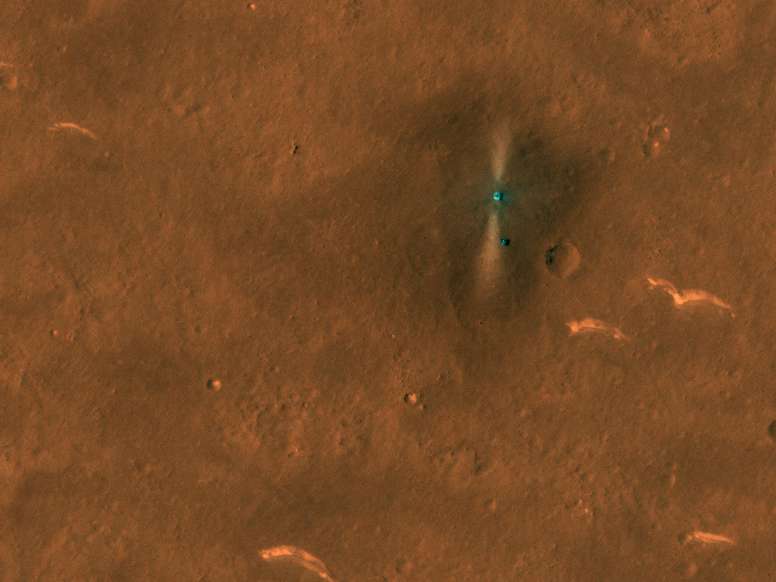
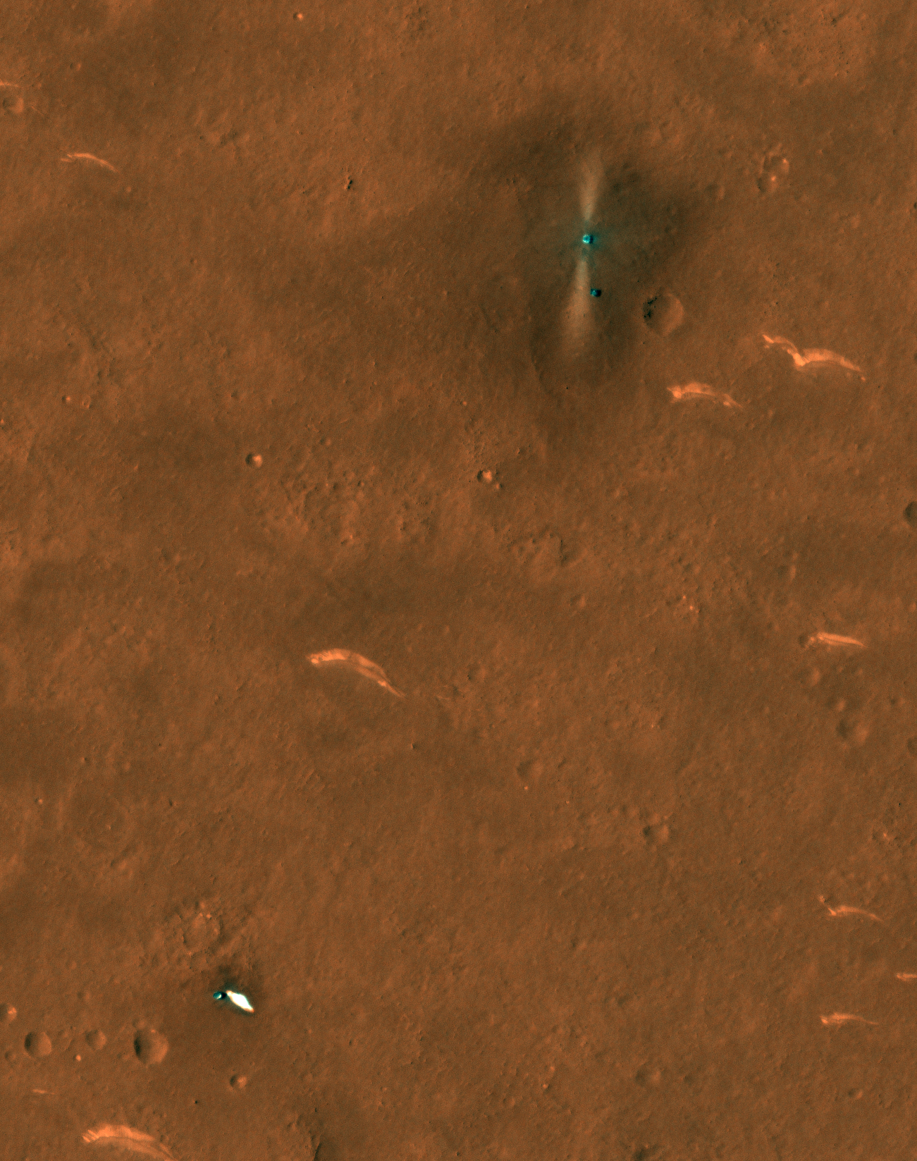

Posted by: Huguet Jun 10 2021, 11:29 AM
Zhurong is at a crater wall on this photo. It just landed beetween 3 huge craters. With lots of smallers ones nearby. Very good pic from Hirise. almost a 10cm per pixel image. Im very impressed. We can see lots of the lander and zhurong details, directions...
A surprise, we can't see tracks. So this terrain is a lot less dust and more rock then the terrain on chang'e 4 path.... (zoom equalized to increase details on RGB), we have lots of craters, the smallest i can see on hirise with 1 meter diameter. and the big 3 towards the lander. (2 almost gone e 1 more visible). Thats crazy, so much more details then i would expect.. Hirise has just imaged like a airplane... Mabe they can reduce more the distance without hitting the atmosphere, or it was the safe limit?
If i was casc,.. i would put zhurong on the direction of the parachute, to survey mars, but to take most information of all the hardware.. One of the top objective would be master the landing process (knowing the efects on every hardware part).

|

|
Posted by: djellison Jun 10 2021, 02:52 PM
Where do you get that number from?
HiRISE has a max of 25cm/px
Posted by: Huguet Jun 10 2021, 03:12 PM
|
|
Its giving me 14.77 cm/px, almost 10 but not 10... Here follows a better calculation. Maybe the 25 cm is the worlst of the best, and in some cases its a little better. But its really less then that, the ramp is 20 cm and would be dificult to see on a 25 cm/px image.
The tracks area reduced like in the last Rear Photo, and the ramp is less then 20 cm... lot less, It is 3 tiny 2->5 cm pieces together in 20 cm..

|

|
Posted by: djellison Jun 10 2021, 04:01 PM
You are measuring an image that has already been blown up. HiRISE is between 30 and 25 cm per pixel. Thats what it does.
Posted by: Huguet Jun 10 2021, 04:18 PM
Can be. I used the image on the Hirise Site: https://www.uahirise.org/hipod/ESP_069665_2055.
If the image is raw, then its a little better resolution, if not they blown it up by almost 200%.
Here follows the original on the site and the detail with 10 px grid.

|

|
Posted by: djellison Jun 10 2021, 04:25 PM
OK - not to belabor this point. HiRISE has a resolution of between 25 and 30cm/pixel. That's not something we need to debate here. That's just a fact.
https://www.uahirise.org/specs/
https://hirise-pds.lpl.arizona.edu/PDS/DOCUMENT/HIRISE_EDR_SIS.PDF
Posted by: Huguet Jun 10 2021, 04:33 PM

|

|
Posted by: djellison Jun 10 2021, 05:00 PM
I give up.
Posted by: Bill Harris Jun 10 2021, 05:15 PM
HiRISE may not be resolving the lander ramp, but may be simply imaging the glint of sunlight off of the ramp components.
But whatever. It's an accomplishment on an accomplishment.
I'm interested in seeing the light-toned flatish rocks up close, here as well as at Jezero. Call me old-fashioned, but I've been a fan of the "Whiterock Formation" for years...
Posted by: mcaplinger Jun 10 2021, 05:22 PM
Exactly what "resolution" means can be debated (pointlessly, IMHO) and can be different from "pixel scale". And sometimes you can see things that are below the resolution limit if they are sufficiently contrasty.
Posted by: volcanopele Jun 10 2021, 05:24 PM
The actual image is now available for your resolution measurement needs:
https://www.uahirise.org/ESP_069665_2055
to mcaplinger: not to mention that effective resolution can differ between the along track and across track directions...
Posted by: Huguet Jun 10 2021, 05:44 PM
I give up: Original IRB jp2 image has the lander with 14 px. The lander on the final processed image has more or less 23 px, which would give it aproximately 18 cm if the res on lander is 29.2. It is actualy exagerated on the maped version, and indeed a good work.

|

|

|
Posted by: Cosmic Penguin Jun 11 2021, 02:40 AM
New photos from the ground are out, including from a deployed camera separated from the underneath of the rover:
Source: http://www.cnsa.gov.cn/n6758823/n6758838/c6812122/content.html / https://mp.weixin.qq.com/s/w_3t4yp7pGjSMl7CTJ1-Gw


|
Posted by: Hungry4info Jun 11 2021, 03:28 AM
These images are really cool. (Source, if the weixin site is loading slowly https://twitter.com/SegerYu/status/1403182448641404932 )

|

|

|
Posted by: Phil Stooke Jun 11 2021, 03:39 AM
Try here too:
http://www.sastind.gov.cn/n112/n117/c6812121/content.html
A big panorama very slow to load (I had to restart it a few times).
Phil
Posted by: Phil Stooke Jun 11 2021, 03:52 AM
Had to play with it, just the horizon - notice the parachute to the SSW (north at the top).
Thank you CNSA/CAST.
Phil
|
Posted by: Explorer1 Jun 11 2021, 04:24 AM
Wow, I wasn't expecting a family portrait from ground level! Incredible!
Nor the depth of the pit from the landing engineers, far more than Phoenix caused. A property of the soil, or of the landing engines?
Posted by: djellison Jun 11 2021, 04:58 AM
One higher power landing engine with small attitude control motors rather than a distribution of many smaller thrusters over the footprint of the lander.
Posted by: Paolo Jun 11 2021, 05:57 AM
what a great way to start the day! (it's 8 AM here...)
so, it finally looks like there is no camera on the lander
Posted by: Phil Stooke Jun 11 2021, 06:59 AM
A circular view of the landing site.
Phil
|
Posted by: bobik Jun 11 2021, 07:09 AM
There is a https://www.polyu.edu.hk/media/media-releases/2020/0723_polyu-contributes-to-the-nations-first-mars/, visible in that https://news.cgtn.com/news/2021-05-19/China-releases-photos-from-Tianwen-1-Mars-probe-after-landing--10osRWAdNPa/img/20704faee9254459810f40e029b20d64/20704faee9254459810f40e029b20d64.jpeg on the edge of the lander platform right from the left ramp.
Posted by: vikingmars Jun 11 2021, 07:14 AM
Thank you Phil
CONGRATULATIONS to CNSA/CAST for this mission to Mars and this very successful EDL
Yes indeed: the nearby parachute and its backshell is nice to see ...and look at the big hole dug by the descent engine 

|

|
Posted by: Phil Stooke Jun 11 2021, 07:41 AM
Yes indeed, a monitoring camera on the lander. We don't have any of its images and may not get them as it's not a science instrument. The article is a little bit ambiguous but I think it means that the camera was used to watch the deployment of solar panels and so on, while the rover was still on the lander (and to confirm safe landing), but not that it was used after rover egress from the lander.
Phil
Posted by: Hungry4info Jun 11 2021, 10:16 AM
I'm just getting 404 errors. Is there another place I can find the panorama?
Posted by: Huguet Jun 11 2021, 10:53 AM
And one Zhurong/Lander easter egg... Beijing 22 Winter Olympics.
It apears the initial turn of Zhurong seens to be colecting PCAM images in a 360o way, to make precise 3d models like on chang'e-4, doesn't look like a simple turn of direction.

|
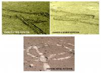
|
Posted by: peter59 Jun 11 2021, 10:56 AM
https://news.cgtn.com/news/2021-06-11/China-releases-Mars-images-taken-by-Zhurong-Mars-rover-1101PvTmIBW/img/13550e12e58a4154a70d66b6c2d58e1f/13550e12e58a4154a70d66b6c2d58e1f.jpeg
Posted by: Cosmic Penguin Jun 11 2021, 11:46 AM
According to CCTV, the photos were taken at:
Panorama: May 18 & 20, 23:00-00:00 UTC
East close-up: May 23, 02:37 UTC
Lander side view: May 26, ~04:00 UTC
Deployed camera rover-lander photo: June 1, 08:09 UTC
The rover has travelled over 80 m so far.
https://9ifly.spacety.com/forum.php?mod=redirect&goto=findpost&ptid=91970&pid=851386
Posted by: marsophile Jun 12 2021, 04:26 AM
The camera-taken "family photo" is so much nicer than the distorted images
stitched together from the robot arm on Curiosity, or even the aerial photos
from Ingenuity. Well, maybe the future fetch rover can get some good shots.
Posted by: tolis Jun 12 2021, 07:55 AM
stitched together from the robot arm on Curiosity, or even the aerial photos
from Ingenuity. Well, maybe the future fetch rover can get some good shots.
Lucky for them, the camera ended up pointing in the right direction for a group selfie.
When you eject something from your vehicle to the ground, you only have so much
attitude control.
Posted by: Bill Harris Jun 12 2021, 11:35 AM
At 0* and 180* azimuth on the 360 pan you can see scoured areas from the jet of the descent rocket. That would be interesting to examine, although with it's no longer chemically pristine.
Posted by: Huguet Jun 12 2021, 12:23 PM
On the image of the lander, if we use only the red channel and change its contrast we get a event on the west and a more clean sky at east. I don't known if it is just heat, sun shine or a dust plume, but it is distinguishbly on the red and don't exist on green and blue channels, mabe indicating a dust plume (Mabe a little sand storm). it exists on the panoramic picture as well and still a west feature. On panoramic image is a contrast of Red minus Blue.

|

|
Posted by: Bill Harris Jun 12 2021, 09:07 PM
Yes, Zuhrong is coreographing a precise series of movements. Impressive.
One nearby feature to visit would be one of those curious arc-shaped wind tails behind light-toned boulders (apparently, at the HiRISE resolution images of the landing site). My initial thought was that these were simply barchan dunes, but they may not be that.
Posted by: vikingmars Jun 13 2021, 07:37 AM
Yes indeed, but not forgetting also the backshell + the heatshield (both located at southwest), if the Chinese engineers want to make an full technical assessment of the behaviour of their components during EDL (very much like the technical visit made during the Opportunity mission).
This kind of technical visit is not recommended for the Perseverance mission which must avoid the contamination of the suite of instruments that seek the traces of past life.
But the Chinese have not the same scientific constraints
...and such visits would provide spectacular images they will like to share worldwide to impress people about their mastering of difficult space exploration techniques
Posted by: Steve G Jun 13 2021, 04:24 PM
When you eject something from your vehicle to the ground, you only have so much
attitude control.
That was no luck. The Chinese knew exactly what they were doing! Kudos to them for the group portrait. It's nice to see such pristine solar panels, and it will be interesting to see if their dust mitigation strategies work.
Posted by: Hungry4info Jun 13 2021, 06:34 PM
Perhaps we'll get a closer look. From https://news.cgtn.com/news/2021-06-12/CNSA-Tianwen-1-mission-achieves-firsts-in-China-s-aerospace-history-111Oj8urZPG/index.html CGTN article (which contains a number of other interesting bits:
"We selected this particular direction for several reasons. The altitude picks up that way, from the ancient martian ocean to land. And that's also where we'll come across some of the most interesting things we care about, like mud volcanoes and sub-surface ice."
Posted by: tolis Jun 13 2021, 07:57 PM
I agree that the Chinese know what they are doing. The point I was trying to make is that, if you let something free-fall even a short distance to the ground, there is always the chance that it will end up in an undesired attitude. But perhaps the camera was not simply dropped to the ground as, for instance, Ingenuity was a while ago and I would not be at all surprised to find out the mission engineers worked out a more deterministic way to deploy that camera.
Posted by: Huguet Jun 13 2021, 08:09 PM

|

|
Posted by: Saturns Moon Titan Jun 14 2021, 08:50 AM
There's a new article on Zhurong's future plans: http://www.ecns.cn/news/2021-06-14/detail-ihanfwct7387903.shtml - "Mars rover to move south after testing"
Zhurong will move southwards to observe and survey mud volcanoes and troughs. I hope this mission lasts well beyond its 90-day design, just like Opportunity and Spirit
Posted by: Phil Stooke Jun 14 2021, 04:21 PM
Chinese versions of this story included illustrations of features to visit. I can't find the links now but I will make my own version.
EDIT: This is the link:
https://news.have8.tv/2863778.html
Phil
Posted by: neo56 Jun 14 2021, 08:40 PM
I added a synthetic sky on post-processing so thathttps://roundme.com/tour/728025/view/2292893/
Posted by: Phil Stooke Jun 14 2021, 09:02 PM
This is the future path suggested in the Chinese media. It visits two substantial impact craters, takes a look at the parachute and crosses a valley floor with a chance that the radar will be able to probe its structure and origin. Notably it does not access any of the 'mud volcanoes'. The most accessible candidate is about 3 km NNW of the lander. There are others to the south and west but still several kilometres beyond Crater B. Incidentally, 'Crater A' and 'Crater B' are the designations they use (with a Chinese word for crater but with Roman letters 'A' and 'B'). Maybe we will see names for them later.
Phil

|
Posted by: vikingmars Jun 15 2021, 07:19 AM
Thanks so much Neo56 for this superb work!
Now, the Zhurong-1 site becomes a real place that can be explored
Posted by: vikingmars Jun 15 2021, 08:35 AM
Phil
Thanks so much Phil for this very informative map
Btw, this is exactly the mission we dreamed of during the Viking times: having a lander with a rover on top of it that is released and comes exploring the surface of Mars. Unfortunately, this Viking III (or Viking'79 or Viking'84) mission was not funded. Fortunately, however, the goals were fulfilled with the rover missions sent to Mars in the next decades, starting with Mars Pathfinder and Sojourner in 1997

|
(Note. One of the Viking III versions is shown here: many variants were studied)
Posted by: Huguet Jun 15 2021, 09:33 AM
Zhurong's Lander Black box. They don't trusted on the success of the landing. The black box would help understand the crash.
Wang Yin said: The Mars Rover beacon device is the worlds first emergency communication payload for spacecraft applications. Its main function is similar to that of the black box on the plane, but it is different. The black box on the plane cannot actively transmit data. , Can only send a positioning signal to be searched. The beacon device can send some key data and signals, which are received by the Martian orbiter, and the key data can be interpreted."
http://www.js.chinanews.com/news/2021/0517/203760.html

|

|

|
Posted by: Huguet Jun 15 2021, 12:41 PM
"The picture shows the development team of the Mars rover emergency beacon device"
Touch Space
Insight Into Space
Change Space
Loved the third... To Construct on Space appears to be the Final Objective.

|
Posted by: Xerxes Jun 15 2021, 03:24 PM
This is a very weird translation of 进入, which is a common word meaning "enter". You might find 请勿进入 written on a door, for example, meaning "do not enter".
Posted by: Huguet Jun 17 2021, 03:02 PM
http://www.chinanews.com/ga/shipin/cns/2021/06-02/news890629.shtml
Rong Qiliang Interview about Zhurong's "火星相机 Mars Camera" or?? "Fire Monitoring Camera".
"we all hope to apply our developed space technology to civilian use. We have all begun to do a lot of work in this area."
Mabe in the future we will have more COTS instruments used in space exploration.
Same team developing the camera since Chang'e3...
https://www.nature.com/articles/d41586-021-01588-6
(Wasn't only me impressed with Hirise image...)
Very complete video explaning key developments done for Tianwen-1 mission:
https://www.youtube.com/watch?v=iIA9r5IAIsE

|
Posted by: Phil Stooke Jun 23 2021, 06:51 AM
This link to a Chinese forum page:
https://9ifly.spacety.com/thread-91970-61-1.html
shows a frame from an EDL video of the Tianwen-1 parachute.
This link:
https://wx2.sinaimg.cn/mw1024/9da82ba5gy1grs4ranas8g20m80cikjw.gif
is to the video!
Phil
Posted by: Toma B Jun 23 2021, 11:02 AM
https://wx2.sinaimg.cn/mw1024/9da82ba5gy1grs4ranas8g20m80cikjw.gif
is to the video!
I get this 403 Forbidden error.
You don't have permission to access the URL on this server.
https://twitter.com/CNSAWatcher/status/1407581638050070529?s=20
Posted by: Huguet Jun 23 2021, 03:34 PM
New Hirise Image, Zhurong going South. Now the Track is clearly visible. Hirise is simplifying the job of mapping Zhurong path...
https://twitter.com/AJ_FI/status/1408108865728794625
Zhurong clearly paid a visit to a stone on its path, before continuing south.
Other link to Lander Parachute Opening:https://m.weibo.cn/status/4651233694713565?

|

|

|
Posted by: djellison Jun 23 2021, 05:05 PM
The second HiRISE image is here : https://www.uahirise.org/ESP_069731_2055
Posted by: Hungry4info Jun 24 2021, 10:34 PM
And here we have a video of the separation of Zhurong from the aeroshell. You can see the aerodynamic plate pop out of the side of the aeroshell after deployment to slow down the aeroshell, helping avoid it crashing into the lander.
https://twitter.com/Kaynouky/status/1408159315987423246
Posted by: djellison Jun 25 2021, 04:02 AM
You got a source for that? It appears to already be fully deployed when the video starts. I believe it deployed before parachute deployment as an aero trim flap
https://twitter.com/TheElegant055/status/1389671920270970885/photo/1
https://twitter.com/CoreGraphite/status/1287020151288868865
Posted by: Phil Stooke Jun 25 2021, 06:07 AM
Showing up on the Chinese 9ifly forum, a different image by the little deployed camera - you can see the lander behind the rover (ignore the red box, it's a mistake).
Phil

|
https://9ifly.spacety.com/thread-91970-63-1.html
Posted by: Hungry4info Jun 25 2021, 10:15 AM
This tweet contains a view from some conference where it looks like these EDL cam videos are being presented. While the "recording of the recording" isn't that great of quality, after the Aeroshell separation video that we've now seen, we then see what looks like a downward-looking camera viewing the surface(? and a couple craters are visible?).
https://twitter.com/SegerYu/status/1408086543177187330
Posted by: Andreas Plesch Jun 25 2021, 03:06 PM
https://9ifly.spacety.com/thread-91970-63-1.html
Could the red box be interpreted to show how the lower frame was cropped after the rover moved to a new position ? The lower position seems to be designed for the group photo so that both rover and lander appear next to each other, after the rover backed away further from the camera.
Posted by: Phil Stooke Jun 25 2021, 05:31 PM
The person who posted the image thought that the released group photo was cropped from a larger frame (which may have been true) and thought that the new image was just that larger frame. But comparison of the images shows clearly that they are different images.
Phil
Posted by: Huguet Jun 25 2021, 09:35 PM
Mabe from another camera, it apears to me that we have two cameras on the released body (the visible two lens on the Zhurong engineering twin). Mabe one with better resolution and other with small resolution just to help position Zhurong before the higher resolution one is used.

|
Posted by: Hungry4info Jun 27 2021, 01:30 AM
This might be the full EDL video. Though the landing video includes so few frames it's somewhat surprising if it is the full video. In any event, it's the clearest version of the landing video yet and we also see parachute deployment from a second upward-facing camera. We also get a longer video of the upward facing camera that monitored aeroshell separation.
https://twitter.com/raz_liu/status/1408958199764455427
Attached are the final three frames of the video, and the only ones that show the descent engine affecting the surface.

|

|

|
Posted by: Hungry4info Jun 27 2021, 01:47 AM
Perhaps I should have waited: here is the full-resolution version of the video in the past post.
https://t.co/UNtMGNl1xI?amp=1
It also contains audio recordings of Zhurong driving down the ramp.
A video from the deployed camera showing Zhurong backing away(!!! ! )
A panorama of the view from Zhurong after its southward drive commenced.
|
|

|
Posted by: Phil Stooke Jun 27 2021, 01:56 AM
See here as well!
https://mp.weixin.qq.com/s/ueCzF5pH6Y0kwEVwLRtfWA
Phil
Posted by: Phil Stooke Jun 27 2021, 02:05 AM
Can't resist doing this...
Phil

|
(EDIT: should be rotated about 10 degrees counterclockwise)
Posted by: Hungry4info Jun 27 2021, 02:26 AM
Apparently there's a higher-resolution image of that panorama somewhere because https://twitter.com/TheElegant055/status/1408959328145530882 has a couple sub-images showing descent hardware that are better than we can see in any of the panoramas that I've seen so far.

|

|
Posted by: Explorer1 Jun 27 2021, 02:47 AM
Wow, is that the actual speed in the backing away footage? The vibration of the radar booms makes it seem so! It's just so smooth!
I'm so glad to be proven wrong and that there is a hose (perhaps not a firehouse) instead of a trickle of data, after all!
Posted by: Cosmic Penguin Jun 27 2021, 03:51 AM
I think CNSA's site have the pictures and videos in full resolution: http://www.cnsa.gov.cn/n6758823/n6758838/c6812196/content.html
Posted by: bobik Jun 27 2021, 06:34 AM

|
Yes, the wireless camera must have two different camera lenses.
Posted by: Hungry4info Jun 27 2021, 12:04 PM
https://twitter.com/AfricanRabbit/status/1409026150190387202 was able to track the heat shield falling in several landing image frames, showing its descent when the frames are aligned to background surface features.
I was completely unable to get the CNSA site to load for me, with multiple attempts to download the full-resolution panorama failing. But a full version is posted to the NASA SpaceFlight forum https://forum.nasaspaceflight.com/index.php?topic=35045.msg2257028#msg2257028.
Posted by: PDP8E Jun 27 2021, 10:46 PM
I put the long-distance image of the Lander thru a deconvolve routine (C++ modified Lucy-Richardson)
I tried to ID the PSF of the lens
GIF

|
Posted by: neo56 Jun 28 2021, 12:15 PM
I completed the sky in post-processing on the 360° panorama taken by Zhurong rover on June 16.
https://flic.kr/p/2m835Sh
https://www.360cities.net/image/sunset-on-utopia-planita-mars
Posted by: Huguet Jun 30 2021, 10:14 AM
A lot more clean sky on the second panorama than the one we got on the first batch of images. Showing difference beetween equalized Red and Blue Channels.
On the new panorama i needed to force the contrast to see some dust.
|
|

|
|
|
Posted by: PaulM Jul 3 2021, 10:44 AM
The Insight Mars lander has unexpectedly high dust levels on its solar panels due a lack of cleaning winds. Insight may therefore not have enough electrical power to continue functioning after a few more months. I have read that a lack of dust devils in orbital photos of the Insight landing site indicated that this problem would likely occur.
What I wondered is whether there is evidence of dust devils in orbital pictures of the Zurong landing site that would indicate that the regular needed cleaning events would take place?
Posted by: Phil Stooke Jul 3 2021, 06:54 PM
It's a good question so I had a look. Here is an example not far from the landing site:

|
There are not many and they are small and faint but they do exist. Pretty much the same was true at Meridiani where cleaning events occurred often enough.
However, DD tracks are visible at InSight's location - see here:

|
- from this paper:
https://www.researchgate.net/publication/340682126_Monitoring_of_Dust_Devil_Tracks_Around_the_InSight_Landing_Site_Mars_and_Comparison_With_In_Situ_Atmospheric_Data
We had a post on here not long ago from Ralph Lorenz saying that they are not energetic enough to help. Not sure I understood why not but I trust him on this and we have the evidence in the lack of cleaning events.
Phil
Posted by: rlorenz Jul 4 2021, 02:48 AM
There are two statistics one can develop from orbital images - the dust devil track formation rate (DD / km2 / Sol), and the track area generation rate (km2 / km2 / Sol). On both of those metrics, Elysium (InSight) was rather weaker than Gusev (Spirit).
If one adopts the imperfect hypothesis that removal of dust from regolith to form a visible trail is a good analog for the removal of dust from a solar panel a meter or so off the ground, then the reciprocal of the area generation rate is basically the interval between cleaning events. That interval appeared to be a few hundred Sols for Gusev, consistent with the cleaning events observed. The reciprocal of the track area generation rate at Elysium, published by Dennis Reiss and myself before the mission, was of the order of ten years, consistent with the non-observation of cleaning events so far.
Why these sites should be so different is not clear. My suspicion is that stronger background winds at Elysium suppress the formation of the largest (most intense) vortices which are needed for dust lifting. There was a bit of a clue about that in the dust devil tracks before landing - Dennis and I noted (a) that most of the Elysium tracks were much narrower than those at Gusev, and (b ) were straighter.
(a) narrow tracks suggests small diameter vortices
(b ) dust devil tracks are often cycloidal, a quasi-random rotating velocity component of a couple of meters adds vectorially to the background wind. If the background wind is stronger, you get tracks with lower sinuosity.
There may well be other factors at work (thermal inertia, regional flows suppressing the growth of the planetary boundary layer, etc.) but this is my best guess as to the reasons. If the story above holds, then at least one might be able to estimate sites of low and high dust removal potential from orbital data. And perhaps the meteorological factors can be satisfactorily predicted with global and regional circulation models.
Posted by: PaulH51 Jul 4 2021, 02:23 PM
Can the Zhurong rover reach a possible Martian mud volcano? video on https://youtu.be/YS9TKs9dpgg
Mars Guy Episode 13 (Mars Guy is Arizona State University associate research professor Dr. Steve Ruff)
Posted by: Bill Harris Jul 8 2021, 02:19 AM
I'd be interested in the field of putative mud volcanoes to the SSW, just beyond the landing ellipse.
--Bill
Posted by: Huguet Jul 9 2021, 02:01 PM
New images released.
Posted by: Huguet Jul 9 2021, 02:05 PM
* The Dune equalized by the close-up images for reference, red channel decrease in 33%, blue channel increase by 33%, overal constrast and intensity increase by 50%.
* Impressive how the dusty over the soil is different in color from the terrain just behind it, that's why the zhurong path is so visible by Hirise.
* This contrast of colors from red to green/blue due to dust is very nice.
* Showing here side by side rock image.
* It apears to me that the botton rock at the close up zhurong path image has a very similar pattern of earth sea rock erosion holes.

|

|

|

|

|

|
Posted by: Huguet Jul 9 2021, 03:35 PM
Again we have dust plume at the horizon.

|
Posted by: Huguet Jul 9 2021, 05:23 PM
Panoramic images from here:
https://www.dailymail.co.uk/sciencetech/article-9773531/Chinas-space-agency-releases-five-new-images-Mars.html?ito=social-twitter_mailonline
and here:
https://twitter.com/ChinaEmbSL/status/1413543477275660292
Posted by: Phil Stooke Jul 9 2021, 09:46 PM
Two images were taken on July 4th and were probably part of a full panorama. By aligning them with features on the distant horizon and then reprojecting them I get this view of the location on that sol.
Phil

|
Posted by: Hungry4info Jul 10 2021, 06:36 PM
https://twitter.com/Kaynouky/status/1413443966419173389 has the newest set of images in full resolution. Attached is a sub-image of the aeroshell. Looks like we can see cables/ropes now?

|
Posted by: Bill Harris Jul 10 2021, 07:00 PM
Closing in, carefully. Much as we did with Oppy's heatshield.
Posted by: Huguet Jul 11 2021, 01:23 PM
* Added one interesting rock that Zhurong passed-by.
* In time: added the image taken by hirise from the parachute on june 06, 1 month ago. The parachute fall moved most of the red dust nearby exposing the soil. Soon we will see how the dust acted on one month period.

|

|

|

|

|

|
Posted by: tolis Jul 11 2021, 03:19 PM
From that distance the aeroshell looks none the worse for wear.
Posted by: Bill Harris Jul 12 2021, 01:38 AM
Indeed. Aeolian processes are a major force on Mars. Erosion, transportation, and deposition as well as sorting. I'm looking forward to determining the composition of the light-toned material in these barchan dunes, as well as figuring a source for this material.
The Rover has given us important clues about the nature of the surface at this site. The blue color of the wheel tracks suggests that the composition of the regolith is basaltic, and the reddish color of the undisturbed ground is coated with the ubiquitous Martian iron oxide dust. I would like to see a close up.image of the wheel track.
--Bill
Posted by: Gladstoner Jul 12 2021, 07:18 PM
Would like to get a closer look at the intriguing structure and texture in this rock:

|
Posted by: vikingmars Jul 12 2021, 08:45 PM
Is it a rock or a piece of fossilized mud ?
Posted by: Phil Stooke Jul 13 2021, 12:42 AM
To me it resembles the weathered rocks around Hank's Hollow at the foot of West Spur in Spirit's early days. Relatively soft and looking eaten away by erosion. If you started out with soft sediments and let them weather for a billion years you might get this.
Phil
Posted by: Huguet Jul 13 2021, 02:15 PM
Thats a shame we don't have close-ups of the landing hole. It apears to have nice features there too. I'm pointing three, with a particular interest on the upper one... It apears to be a duplicated pattern, mabe a glitch at the camera or due to the rocket engine exaustion, but it is interesting...

|

|
Posted by: Hungry4info Jul 13 2021, 05:38 PM
That is almost certainly an artifact of the mosaic stitching.
Posted by: Phil Stooke Jul 13 2021, 07:44 PM
Right! You can see the duplication continues above the rock in the area of small loose pebbles.
Phil
Posted by: Huguet Jul 13 2021, 08:33 PM
Posted by: Huguet Jul 15 2021, 10:29 AM
It didn't bother to stop by at the parachute...
http://www.chinanews.com/gn/2021/07-15/9520667.shtml
"As of July 15th, the rover has been working for 60 Mars days, has traveled 450 meters in total, and the orbiter has been in orbit for 357 days. The working conditions are normal. (CCTV reporter Li Xia Tao Jiashu National Space Administration Geng Yan Chen Gang)"
Extended life expected?
http://www.chinanews.com/gn/2021/07-14/9519372.shtml
"If the sun is located between the earth and the probe, it will also cause a long-term communication interruption. The operation of the probe cannot be seen on the ground, and the probe cannot receive ground instructions. In fact, these seemingly difficult issues were fully considered by scientists before the launch of the Tianwen-1 probe. Niu Junpo said that the detector has already added autonomous functions as early as the design stage. In the case of communication delays and communication interruptions, the detector can complete on-orbit operation independently without relying on ground operation and control."

|

|

|

|

|
Posted by: Steve G Jul 15 2021, 12:55 PM
This is the first ever close up look we've ever had of a parachute and aeroshell. Is my imagination getting the better of me or has the wind pushed the parachute on top of it self. Note the apparent outline, and possible dragging on the surface.

|
Posted by: Huguet Jul 15 2021, 01:25 PM

|
Posted by: djellison Jul 15 2021, 01:51 PM
If you look at HiRISE images of newly landed chutes they all do some version of that over the first couple of months fold up or roll around a bit and then settle down.
Posted by: Bill Harris Jul 15 2021, 08:38 PM
Has there been a nickname floated for the Zhurong Rover, as was done for Oppy?
--Bill
Posted by: Phil Stooke Jul 16 2021, 02:37 AM
I think I have seen it abbreviated to 'Rong'.
Phil
Posted by: Bill Harris Jul 16 2021, 11:23 AM
That makes sense, but it doesn't have much of a ring to it.
Not complaining; just sayin'.
--Bill
Posted by: Huguet Jul 16 2021, 12:49 PM
Zhu Rong is mythological and is a game character, "Said to be the daughter of the God of Fire" on Dynasty Warriors... It is just a name that don't need a nickname... One fun fact, as Zhurong rover is tall, it is almost the same height as the character, less then 10cm of difference and the hair of the character is mostly white...

|
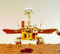
|
Posted by: Bill Harris Jul 16 2021, 06:22 PM
"It is just a name that don't need a nickname..."
That makes sense, too. Americans tend to shorten names, especially multisyllabic names, to nicknames.
Op-por-tun-ity became Oppy and Curi-os-it-y became Cury.
Posted by: Xerxes Jul 16 2021, 08:37 PM
It's not just Americans. The Chinese have an even greater tendency to shorten phrases to a few characters. However, as Zhurong is already the short form of 祝融号火星车 (Zhurong Hao Huoxing Che), shortening it further doesn't make a lot of sense. On the other hand, if one wanted to convey the same sort of baby-babble as Oppy, one might call it Zhuzhu.
Posted by: Huguet Jul 19 2021, 05:06 PM
http://www.chinanews.com/gn/2021/07-17/9522472.shtml
Passed 500m... "the second dune is about to be reached, and detailed exploration of the dune and surrounding environment is planned" It apears they will release a better batch of scientific data (images by now) on the second dune then on the first one. Lots of interesting features here... If CNSA is receiving raw frames, would be interesting to see it. But i believe all the image processing are being made by zhurong and only stitched images are coming to control center... If im wrong i would love to see more raw frames... the 2 close-up images apears to be raw frames.
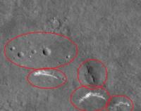
|
Posted by: Phil Stooke Jul 23 2021, 06:23 AM
https://mp.weixin.qq.com/s/w4rLn3Hy47Ei9dLWknGXOQ
First Chinese map of Zhurong's travels and a new image of some dust drifts.
Phil
Posted by: Huguet Jul 23 2021, 01:03 PM

|
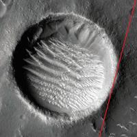
|
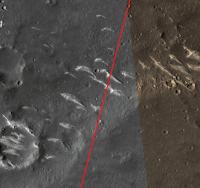
|
Posted by: tolis Jul 23 2021, 02:18 PM
Moving much faster than Yutu-2, for instance.
Posted by: Phil Stooke Jul 23 2021, 03:41 PM
Much faster! Yutu 2 can only drive about 6 days each month - 3 in the morning, 3 in the afternoon with no driving for about 6 days around lunar noon and of course no driving in the lunar night. Zhurong can drive every day. Also the surface is much smoother and they do not have to do the tricky maneuvering to place the body-mounted VNIS on a target.
Phil
Posted by: Hungry4info Jul 23 2021, 07:33 PM
Here's a link to a full-resolution view of the new image.
https://pbs.twimg.com/media/E69n8QIVoAAu2ui?format=jpg&name=4096x4096
Given the distortion at the bottom of the image, it appears to be a segment of a larger panorama.
Posted by: Bill Harris Jul 24 2021, 03:25 PM
I assume that the red line in the image in Post293 is just a bearing from the lander to the E. Rim of that large crater.
Zhurong is moving at a fairly good clip. Do we suppose autonomous Obstacle Avoidance, or are they doing planned short segments?
--Bill
Posted by: Huguet Jul 24 2021, 07:29 PM
I have read but can't find now the source, they explaining that the best direction was south, in direction of ancient ocean border.
Posted by: Phil Stooke Jul 24 2021, 10:50 PM
Here's an article previously linked to which describes possible targets.
Phil
https://news.have8.tv/2863778.html
Posted by: Bill Harris Jul 25 2021, 02:00 AM
That is reasonable. I don't recall seeing an explanation, and my Chinese is rusty enough that I can't go to a first-hand source.
As I said, the rover is making good progress.
--Bill
Powered by Invision Power Board (http://www.invisionboard.com)
© Invision Power Services (http://www.invisionpower.com)