Eagle and Endurance DEM's available! |

Eagle and Endurance DEM's available! |
 May 17 2006, 09:30 AM May 17 2006, 09:30 AM
Post
#1
|
|||
|
Founder  Group: Chairman Posts: 14431 Joined: 8-February 04 Member No.: 1 |
http://anserver1.eprsl.wustl.edu/anteam/mera/mer_osu.htm
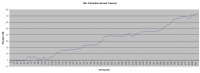
Two things.. 1. Phil - YAY - bundle adjusted references for all the sites in the top two txt files!!! And 2. Um....what does one do with those Bin's. Damn I wish I could code...if anyone knows a means to get that lot into any sort of appropriate 3D format they win the UMSF 'special cookie' award  Just for fun - I bunged the XY data of MERB into Excel. It's not 'square' i.e. it's not accurate - but I think I'll go for something accurate in Photoshop Also - Z axis against Sol for Spirit...I've seen that graph somewhere else...but making it ones self from data is always much more fun - you can clearly see Bonneville, Missoula, West Spur and the return to Larrys Lookout. Doug
Attached thumbnail(s)
|
||
 |
 
|
||
 |
|
May 18 2006, 04:19 AM
Post
#2
|
|||
 Senior Member Group: Members Posts: 2228 Joined: 1-December 04 From: Marble Falls, Texas, USA Member No.: 116 |
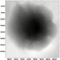
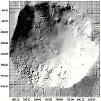
Nice work with that last one, Doug. I need to refresh my skills with this grid plotting software, as I didn't create anything as pretty as your view. I'm working with the ASCII files, since they are easily accepted by my software. I can see that there is quite a bit of detail in the data; now to learn to bring it out as you have. I tried a shaded relief map of Endurance, but it was difficult to make it look well, and it appears to have a strange network of artifacts. I wonder if that is some of what they hope to eventually clean up.
I found it curious that the ASCII file for Eagle was huge...60+ MB, while that for Endurance was relatively small.
Attached thumbnail(s)
-------------------- ...Tom
I'm not a Space Fan, I'm a Space Exploration Enthusiast. |
||
|
|
|
||
 djellison Eagle and Endurance DEM's available! May 17 2006, 09:30 AM
 helvick QUOTE (djellison @ May 17 2006, 10:30 AM)... May 17 2006, 04:35 PM djellison I've begun to make some progress - it's ge... May 17 2006, 05:16 PM
 helvick QUOTE (djellison @ May 17 2006, 06:16 PM)... May 17 2006, 07:52 PM helvick QUOTE (helvick @ May 17 2006, 08:52 PM) I... May 17 2006, 08:03 PM helvick Something definitely odd - the file labelled Motor... May 17 2006, 09:00 PM djellison Obviously there are artifacts in the Endurance DEM... May 17 2006, 10:46 PM helvick QUOTE (djellison @ May 17 2006, 11:46 PM)... May 17 2006, 11:01 PM djellison I used the Ascii files with Surfer, but then 3dem ... May 18 2006, 07:00 AM djellison 6.6 Megish...
http://www.unmannedspaceflight.com/d... May 18 2006, 10:21 AM algorimancer QUOTE (djellison @ May 18 2006, 05:21 AM)... Jun 24 2006, 01:14 AM Pertinax Beautifull work -- particularly nice with the over... May 18 2006, 01:11 PM Phil Stooke Very nice maps. The artifacts in the Endurance ma... May 18 2006, 01:22 PM aldo12xu Great piece of work, Doug. In the video, it reall... May 18 2006, 04:03 PM
helvick QUOTE (djellison @ May 17 2006, 06:16 PM)... May 17 2006, 07:52 PM helvick QUOTE (helvick @ May 17 2006, 08:52 PM) I... May 17 2006, 08:03 PM helvick Something definitely odd - the file labelled Motor... May 17 2006, 09:00 PM djellison Obviously there are artifacts in the Endurance DEM... May 17 2006, 10:46 PM helvick QUOTE (djellison @ May 17 2006, 11:46 PM)... May 17 2006, 11:01 PM djellison I used the Ascii files with Surfer, but then 3dem ... May 18 2006, 07:00 AM djellison 6.6 Megish...
http://www.unmannedspaceflight.com/d... May 18 2006, 10:21 AM algorimancer QUOTE (djellison @ May 18 2006, 05:21 AM)... Jun 24 2006, 01:14 AM Pertinax Beautifull work -- particularly nice with the over... May 18 2006, 01:11 PM Phil Stooke Very nice maps. The artifacts in the Endurance ma... May 18 2006, 01:22 PM aldo12xu Great piece of work, Doug. In the video, it reall... May 18 2006, 04:03 PM |

|
Lo-Fi Version | Time is now: 20th April 2024 - 01:42 AM |
|
RULES AND GUIDELINES Please read the Forum Rules and Guidelines before posting. IMAGE COPYRIGHT |
OPINIONS AND MODERATION Opinions expressed on UnmannedSpaceflight.com are those of the individual posters and do not necessarily reflect the opinions of UnmannedSpaceflight.com or The Planetary Society. The all-volunteer UnmannedSpaceflight.com moderation team is wholly independent of The Planetary Society. The Planetary Society has no influence over decisions made by the UnmannedSpaceflight.com moderators. |
SUPPORT THE FORUM Unmannedspaceflight.com is funded by the Planetary Society. Please consider supporting our work and many other projects by donating to the Society or becoming a member. |
|