Printable Version of Topic
Click here to view this topic in its original format
Unmanned Spaceflight.com _ Titan _ T46 (Nov. 3, 2008 / Rev 91)
Posted by: Juramike Nov 3 2008, 02:53 AM
The T46 Titan Flyby Mission Description is now up:
http://saturn.jpl.nasa.gov/multimedia/products/pdfs/20081103_titan_mission_description.pdf
-Mike
Posted by: Vultur Nov 3 2008, 04:09 AM
The search for lightning is exciting - as you said on the ethane lakes thread, that could mean a lot for organic molecules there.
As for the mapping, how many flybys till we have a full map?
I don't really understand the radio studies of the atmosphere, but I'm sure they'll be interesting too.
Posted by: remcook Nov 3 2008, 10:28 AM
With the radio occultations you can, in principle, determine really accurate temperature profiles of the atmosphere with high vertical resolution. What you actually measure (if I have it correctly) is the bending angle of the radio waves as they travel from the spacecraft, through the atmosphere, to the Earth's receivers. From this, you can work out atmospheric density and from this, if you know what the composition of the atmosphere is, you can get temperature. Problems are you apparently need to know the position of the spacecraft really accurately and you need to know the composition of the atmosphere. Also, you get results at only a few points throughout the mission. Good things are that you can probe the troposphere, which is where lots of the interesting weather is happening and you would otherwise not be able to distinguish temperature from e.g. methane abundance. Combination of radio occultation and far-infrared observations can in principle do this.
Posted by: Juramike Nov 4 2008, 05:50 PM
From the mission description:
Bistatic experiments can be used to infer dielectic constant. Dielectric constant tells you how polar the material is: water being very polar with a large dielectric constant, hydrocarbon being non-polar with a low dielectric constant.
[-25- -30S, 90-110W] is just a tad to the NW of Hotei Arcus, Xanadu. If this is a cryo-caldera (like Yellowstone or Craters of the Moon) with expesed cryobasalt, you'd expect a lot of exposed high-dielectric constant ice.
[25-30N. 200-220 W] is in the Dilmun peninsula just a tad WNW of the Dancing Monkey (or Flying Spaghetti Monster) feature. Depending on the resolution, you might see if the dark pattern forming the Dancing Monkey are composed of low dielectric constant dune sands or higher dielectric constant exposed water ice. (I favor an even lower dielectric constant organic tar fill. I think this might be Deep Black unit deep in the cracks.)
-Mike
Posted by: Juramike Nov 5 2008, 04:43 AM
New images are up!
http://saturn.jpl.nasa.gov/multimedia/images/raw/raw-images-details.cfm?feiImageID=173052
Swirly patterns down in the smoke...
(Another caudal-like shape down there?)
-Mike
Posted by: ngunn Nov 5 2008, 11:51 AM
Is this Hotei Arcus? It will be interesting to look for any topographic shading at the terminator. Can't wait to see the processed mosaics.
http://saturn.jpl.nasa.gov/multimedia/images/raw/raw-images-details.cfm?feiImageID=173100
Posted by: Juramike Nov 7 2008, 01:16 PM
http://ciclops.org/view/5361/Rev_92?js=1 description mentions a two frame ISS mosaic to be was acquired on November 6.
Might be a good view of Kraken Mare at sunrise.
-Mike
Posted by: ngunn Nov 10 2008, 10:21 AM

Well it's visible:
http://saturn.jpl.nasa.gov/multimedia/images/raw/casJPGFullS45/N00123311.jpg
If I'm reading it right the 'toe of Italy' seems less distinct than the bay to the left of it in this view. I'll be interested to learn how these images look to the experts who are seeing the professional versions.
Posted by: Juramike Dec 19 2008, 08:00 AM
Partial higher-res T46 mosaic of Hotei Arcus, on top of T47 basemap mosaic with T13 and T41 RADAR sections AND VIMS T20.
All artfully animated with fade effects....
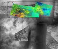
|
(click to animate)
Boy, there's a lot of cool stuff going on in here. I've almost got an overlap of T13 RADAR vs. ISS. So close....
The VIMS T20 yellow blob at the bottom of the VIMS section appears to correlate with the ISS medium bright section just NE of "The Pinecone" (at center left). The VIMS and RADAR arc also almost line up with the ISS arc.
-Mike
Powered by Invision Power Board (http://www.invisionboard.com)
© Invision Power Services (http://www.invisionpower.com)