Google Mars 3d (With HiRISE!), Part of Google Earth 5 |

  |
Google Mars 3d (With HiRISE!), Part of Google Earth 5 |
 Feb 4 2009, 09:45 PM Feb 4 2009, 09:45 PM
Post
#16
|
|
|
Newbie  Group: Members Posts: 6 Joined: 25-January 08 Member No.: 4033 |
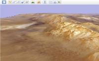
This is amazing. With the terrain mesh detail and aniso filtering applied in the options the detail is very good, its almost like being there.
Just tried the lighting options Sets the correct lighting on the landscape as of now, its sunset from the floor of the Valles Marineris 
|
 |
 
|
|
Feb 5 2009, 03:56 AM
Post
#17
|
|
 Senior Member Group: Members Posts: 3419 Joined: 9-February 04 From: Minneapolis, MN, USA Member No.: 15 |
I was impressed by the very accurate 3d renderings of locations where they have been able to interpolate good terrain models. For example, I was able to see, with a very high degree of accuracy, what Victoria looks like from on top of the Soup Dragon...
 -the other Doug -------------------- The trouble ain't that there is too many fools, but that the lightning ain't distributed right. -Mark Twain
|
|
|
|
|
Feb 5 2009, 04:41 AM
Post
#18
|
|
 Senior Member Group: Members Posts: 1281 Joined: 18-December 04 From: San Diego, CA Member No.: 124 |
I love it! But is there anyway to get rid of that blue sky on mars?
And it has crashed my mac occasionally loading a MOC image... -------------------- Lyford Rome
"Zis is not nuts, zis is super-nuts!" Mathematician Richard Courant on viewing an Orion test |
|
|
|
|
Feb 5 2009, 07:48 AM
Post
#19
|
|
 Member Group: Members Posts: 399 Joined: 28-August 07 From: San Francisco Member No.: 3511 |
This IS the answer to those IAS Viewer problems on my PPC Mac (never resolved),
I can't remember if Google Earth was around when MRO launched, they've come a long way...
-------------------- 'She drove until the wheels fell off...'
|
|
|
|
|
Feb 5 2009, 10:48 AM
Post
#20
|
|
|
Founder Group: Chairman Posts: 14432 Joined: 8-February 04 Member No.: 1 |
QUOTE (dvandorn @ Feb 5 2009, 03:56 AM)  I was able to see, with a very high degree of accuracy, what Victoria looks like from on top of the Soup Dragon... That's the USGS HiRISE DEM work. It's amazing. |
|
|
|
|
Feb 6 2009, 05:08 AM
Post
#21
|
|
 Senior Member Group: Members Posts: 2228 Joined: 1-December 04 From: Marble Falls, Texas, USA Member No.: 116 |
QUOTE (lyford @ Feb 4 2009, 10:41 PM) I love it! But is there anyway to get rid of that blue sky on mars? That's curious. The sky is a gradation of brownish shades on my system.-------------------- ...Tom
I'm not a Space Fan, I'm a Space Exploration Enthusiast. |
|
|
|
|
Feb 6 2009, 05:35 AM
Post
#22
|
||
|
Senior Member Group: Members Posts: 1281 Joined: 18-December 04 From: San Diego, CA Member No.: 124 |
Huh - I must have the uncalibrated version!
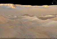
Melas Chasma, Blue Sky Edition -------------------- Lyford Rome
"Zis is not nuts, zis is super-nuts!" Mathematician Richard Courant on viewing an Orion test |
|
|
|
|
|
|
Feb 6 2009, 05:41 AM
Post
#23
|
||
|
Senior Member Group: Members Posts: 1281 Joined: 18-December 04 From: San Diego, CA Member No.: 124 |
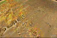
QUOTE (djellison @ Feb 5 2009, 02:48 AM) That's the USGS HiRISE DEM work. It's amazing. Forget the view from the top, here's from the middle of the Victoria Crater in the dunes looking up!
There is elevation data for the individual ripples!!!! Also, I turned of the atmosphere so I wouldn't be distracted by the blueness. There has to be a setting that I am missing somewheres. -------------------- Lyford Rome
"Zis is not nuts, zis is super-nuts!" Mathematician Richard Courant on viewing an Orion test |
|
|
|
|
|
|
Feb 6 2009, 03:31 PM
Post
#24
|
|
 Member Group: Members Posts: 646 Joined: 23-December 05 From: Forest of Dean Member No.: 617 |
That would have made an interesting first post-landing image...
-------------------- --
Viva software libre! |
|
|
|
|
Feb 6 2009, 03:34 PM
Post
#25
|
|
 Senior Member Group: Moderator Posts: 2785 Joined: 10-November 06 From: Pasadena, CA Member No.: 1345 |
QUOTE (imipak @ Feb 6 2009, 10:31 AM) That would have made an interesting first post-landing image... (...and possibly for the entire mission.) -------------------- Some higher resolution images available at my photostream: http://www.flickr.com/photos/31678681@N07/
|
|
|
|
|
Feb 6 2009, 04:27 PM
Post
#26
|
|
|
Member Group: Members Posts: 320 Joined: 19-June 04 Member No.: 85 |
Wow, this is amazing! I was flying over the Columbia Hills, Endurance and Victoria for a couple of hours last night.
I'm a newbie to Google Earth......how do I turn off the place names and all those red lines (image boundaries?)? I want to see nothing but the Martian terrain. -------------------- |
|
|
|
|
Feb 6 2009, 04:40 PM
Post
#27
|
||
 Senior Member Group: Moderator Posts: 2262 Joined: 9-February 04 From: Melbourne - Oz Member No.: 16 |
QUOTE (aldo12xu @ Feb 6 2009, 04:27 PM) I'm a newbie to Google Earth......how do I turn off the place names and all those red lines (image boundaries?)? I want to see nothing but the Martian terrain. Bottom left there is a window called Layers where you can tick/untick various boxes to turn those things on/off. Turn them all off apart from Terrain (the bottom one) for the true Mars Just realized that you can have outlines of lots (all?) HiRISE, CTX, MOC, HRSC and CRISM images with links to the image page on the web, by turning on the layers.
-------------------- |
|
|
|
|
|
|
Feb 6 2009, 04:55 PM
Post
#28
|
||
|
Senior Member Group: Moderator Posts: 2262 Joined: 9-February 04 From: Melbourne - Oz Member No.: 16 |
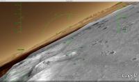
And for those that might not have realized, the flight simulator works on Mars as well!
I've just been annoying Spirit, by buzzing her in my F16. If you don't know about it, there is a fully functioning Flight Simulator built into Google Earth as an 'easter egg' - press Ctrl + Alt + A ( Cmd + Option + A on the Mac) to enter (after you've done it once a menu item appears under Tools). Have fun. http://earth.google.com/userguide/v5/ug_flightsim.html
Attached thumbnail(s)
-------------------- |
|
|
|
|
|
|
Feb 6 2009, 05:03 PM
Post
#29
|
|
|
Member Group: Members Posts: 320 Joined: 19-June 04 Member No.: 85 |
Man, oh, man, this keeps getting better and better!! Can't wait to get home to try it out. Thanks James!
-------------------- |
|
|
|
|
Feb 6 2009, 06:27 PM
Post
#30
|
|
|
Senior Member Group: Members Posts: 1281 Joined: 18-December 04 From: San Diego, CA Member No.: 124 |
Am I the only one on UMSF with the Blue Sky Bug? I am on a Macbook running 10.5
-------------------- Lyford Rome
"Zis is not nuts, zis is super-nuts!" Mathematician Richard Courant on viewing an Orion test |
|
|
|
|

|
Lo-Fi Version | Time is now: 24th April 2024 - 06:13 AM |
|
RULES AND GUIDELINES Please read the Forum Rules and Guidelines before posting. IMAGE COPYRIGHT |
OPINIONS AND MODERATION Opinions expressed on UnmannedSpaceflight.com are those of the individual posters and do not necessarily reflect the opinions of UnmannedSpaceflight.com or The Planetary Society. The all-volunteer UnmannedSpaceflight.com moderation team is wholly independent of The Planetary Society. The Planetary Society has no influence over decisions made by the UnmannedSpaceflight.com moderators. |
SUPPORT THE FORUM Unmannedspaceflight.com is funded by the Planetary Society. Please consider supporting our work and many other projects by donating to the Society or becoming a member. |
|