Journey to Mt Sharp - Part 4: Beyond the Kimberley, Sol 634 [May 19, '14] to 706 [Jul 31, '14] |

  |
Journey to Mt Sharp - Part 4: Beyond the Kimberley, Sol 634 [May 19, '14] to 706 [Jul 31, '14] |
 May 19 2014, 07:00 PM May 19 2014, 07:00 PM
Post
#1
|
||
 Administrator  Group: Admin Posts: 5172 Joined: 4-August 05 From: Pasadena, CA, USA, Earth Member No.: 454 |
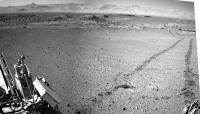
I'd say that the sol 634 drive put the Kimberley in the rear-view mirror, so it's time for a new thread! Let's see how fast they can move toward Murray Buttes now!
Attached thumbnail(s)
-------------------- My website - My Patreon - @elakdawalla on Twitter - Please support unmannedspaceflight.com by donating here.
|
|
 |
 
|
|
|
May 19 2014, 07:44 PM
Post
#2
|
||
 Junior Member Group: Members Posts: 73 Joined: 10-May 06 From: Spain Member No.: 770 |
To release the new thread.
 Although there are still some images come, first version of the navcam right on Sol 634, leaving Kimberley.
|
|
|
|
|
|
|
May 19 2014, 08:56 PM
Post
#3
|
||
|
Member Group: Members Posts: 866 Joined: 15-March 05 From: Santa Cruz, CA Member No.: 196 |
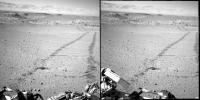
getting perspective on the egress to the wild open yonder again (crosseye)
|
|
|
|
|
|
|
May 19 2014, 10:38 PM
Post
#4
|
|
|
Member Group: Members Posts: 201 Joined: 16-December 13 Member No.: 7067 |
First half of the 634 drive into the crater:
http://i.imgur.com/0g2IPYw.gif Anaglyph: http://i.imgur.com/oBYTZdX.gif |
|
|
|
|
May 19 2014, 10:59 PM
Post
#5
|
||
|
Solar System Cartographer Group: Members Posts: 10150 Joined: 5-April 05 From: Canada Member No.: 227 |
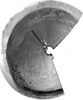
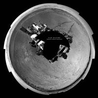
A circular version of Dig's partial panorama. Map update tomorrow (I'm home but this is a holiday in Canada)
EDIT - and we have a name! The rocky area SW of the rover is "Wesley Yard" (http://mars.jpl.nasa.gov/msl/images/MSL_Tr...ol0634-full.jpg) Thanks Fred! Much appreciated. PS: nice hat. Phil
-------------------- ... because the Solar System ain't gonna map itself.
Also to be found posting similar content on https://mastodon.social/@PhilStooke NOTE: everything created by me which I post on UMSF is considered to be in the public domain (NOT CC, public domain) |
|
|
|
|
|
|
May 20 2014, 12:50 AM
Post
#6
|
|||
|
Solar System Cartographer Group: Members Posts: 10150 Joined: 5-April 05 From: Canada Member No.: 227 |
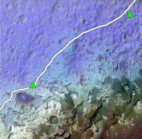
Here I have 'borrowed' jmknapp's nice topo map (posted in the route maps) and merged it with a CTX image. The red and orange hills at lower right are in the big dune field. This shows nicely that we have 1 km or so of driving across the depression we're in now, and then it will be uphill most of the time. The dunes are not in the lowest part of the crater, they are wrapped around the lower slopes of the hill.
Our current position is in the top right corner. Incidentally, we are about to move into the next map quadrangle, with a different source of names. We already crossed into it very briefly and then back into the Kimberley quad shortly before arriving at Kimberley. Phil
EDIT: version with the original route plan on it:
-------------------- ... because the Solar System ain't gonna map itself.
Also to be found posting similar content on https://mastodon.social/@PhilStooke NOTE: everything created by me which I post on UMSF is considered to be in the public domain (NOT CC, public domain) |
||
|
|
|
||
|
May 20 2014, 06:01 AM
Post
#7
|
||
|
Senior Member Group: Members Posts: 2819 Joined: 22-April 05 From: Ridderkerk, Netherlands Member No.: 353 |
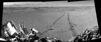
Looking back on Sol 634 with the Navcam L camera.
Jan van Driel
|
|
|
|
|
|
|
May 20 2014, 09:57 AM
Post
#8
|
|
 Senior Member Group: Members Posts: 1619 Joined: 12-February 06 From: Bergerac - FR Member No.: 678 |
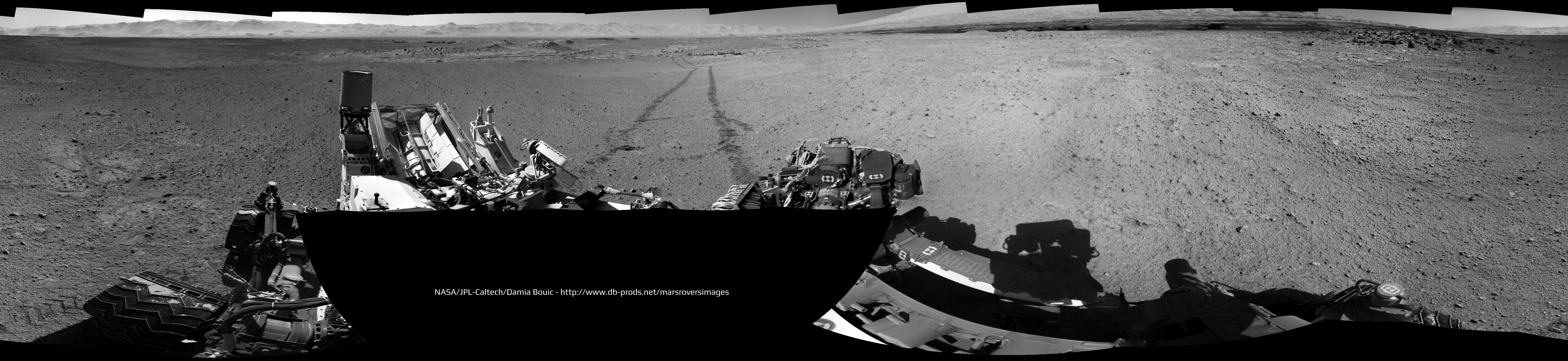
Sol 634 complete panoramic :
-------------------- |
|
|
|
|
May 20 2014, 10:47 AM
Post
#9
|
||
|
Junior Member Group: Members Posts: 73 Joined: 10-May 06 From: Spain Member No.: 770 |
Damia, you've passed by a few minutes.
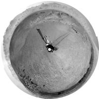
 Well, my version. Navcam Right Sol 634 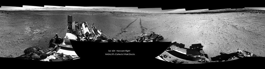 Click on image for full resolution And polar projection
|
|
|
|
|
|
|
May 20 2014, 11:01 AM
Post
#10
|
|
 Senior Member Group: Members Posts: 1465 Joined: 9-February 04 From: Columbus OH USA Member No.: 13 |
I figured out how to get a higher-res topo map out of MATLAB, 4800x3600: topo4800.png
The days of easy riding may be getting short. -------------------- |
|
|
|
|
May 20 2014, 02:01 PM
Post
#11
|
|
|
Member Group: Members Posts: 201 Joined: 16-December 13 Member No.: 7067 |
Completed Sol 634 drive, HTML5 link - Right click to show controls
Completed drive anaglyph Finished the 634 3D pan album http://imgur.com/a/pmZkq EDIT: created a stretched anaglyph album http://imgur.com/a/D7DG8#0 One extra mid-drive anaglyph http://i.imgur.com/29lPTbP.jpg |
|
|
|
|
May 20 2014, 04:23 PM
Post
#12
|
||
|
Solar System Cartographer Group: Members Posts: 10150 Joined: 5-April 05 From: Canada Member No.: 227 |
Finally getting back to normal. Here's a circular version of the full 634 pan borrowed from Damia:
Phil -------------------- ... because the Solar System ain't gonna map itself.
Also to be found posting similar content on https://mastodon.social/@PhilStooke NOTE: everything created by me which I post on UMSF is considered to be in the public domain (NOT CC, public domain) |
|
|
|
|
|
|
May 20 2014, 06:07 PM
Post
#13
|
||
|
Senior Member Group: Members Posts: 2819 Joined: 22-April 05 From: Ridderkerk, Netherlands Member No.: 353 |
The Navcam L view on Sol 634.
Jan van Driel
|
|
|
|
|
|
|
May 20 2014, 07:22 PM
Post
#14
|
|
|
Member Group: Members Posts: 201 Joined: 16-December 13 Member No.: 7067 |
Here is the Sol 635 anaglyph pan.
http://imgur.com/a/EUoVu#0 Here is the 635 drive http://i.imgur.com/gu1vOHX.gif Here is the drive anaglyph (minus one corrupted frame) http://i.imgur.com/S5HAGOe.gif And here is the last segment separated: feels nicer when it is continuous http://i.imgur.com/oRK5INy.gif |
|
|
|
|
May 21 2014, 06:28 AM
Post
#15
|
||
|
Senior Member Group: Members Posts: 2819 Joined: 22-April 05 From: Ridderkerk, Netherlands Member No.: 353 |
The Navcam L view on Sol 635.
Jan van Driel
|
|
|
|
|
|
|

|
Lo-Fi Version | Time is now: 24th April 2024 - 06:49 AM |
|
RULES AND GUIDELINES Please read the Forum Rules and Guidelines before posting. IMAGE COPYRIGHT |
OPINIONS AND MODERATION Opinions expressed on UnmannedSpaceflight.com are those of the individual posters and do not necessarily reflect the opinions of UnmannedSpaceflight.com or The Planetary Society. The all-volunteer UnmannedSpaceflight.com moderation team is wholly independent of The Planetary Society. The Planetary Society has no influence over decisions made by the UnmannedSpaceflight.com moderators. |
SUPPORT THE FORUM Unmannedspaceflight.com is funded by the Planetary Society. Please consider supporting our work and many other projects by donating to the Society or becoming a member. |
|