Spirit retrospective, - a few details from my current project |

  |
Spirit retrospective, - a few details from my current project |
 Feb 6 2012, 05:55 PM Feb 6 2012, 05:55 PM
Post
#16
|
||
|
Solar System Cartographer  Group: Members Posts: 10229 Joined: 5-April 05 From: Canada Member No.: 227 |
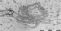
... and a comparison of project mapping and my new map a little west of West Spur. This is a slide for a presentation I'm giving here in London on Feb. 17th.
The orange line is the project map based on 'dead reckoning' with occasional ties to landscape features seen in MOC images. Dead reckoning includes knowing the intended direction and using the wheel turns to estimate distance. The ties to topography were necessarily approximate because of the limited resolution of MOC (how amazing it is to be saying that - grown men wept at the beauty of the MOC images at the time, now they are of limited resolution!) A few points found by feature matching are shown as crosses on or near the route. My route is the black line. It follows the route quite well, but actual end of drive locations are often out by 15 to 30 m along the route. These locations are matched to individual boulders and I would stake what remains of my reputation on their accuracy... most of the time! The square grid is at 100 m spacing. Phil
-------------------- ... because the Solar System ain't gonna map itself.
Also to be found posting similar content on https://mastodon.social/@PhilStooke Maps for download (free PDF: https://upload.wikimedia.org/wikipedia/comm...Cartography.pdf NOTE: everything created by me which I post on UMSF is considered to be in the public domain (NOT CC, public domain) |
|
 |
 
|
|
|
Mar 4 2012, 03:05 PM
Post
#17
|
||
|
Solar System Cartographer Group: Members Posts: 10229 Joined: 5-April 05 From: Canada Member No.: 227 |
Another little detail from long ago and far away...
Phil -------------------- ... because the Solar System ain't gonna map itself.
Also to be found posting similar content on https://mastodon.social/@PhilStooke Maps for download (free PDF: https://upload.wikimedia.org/wikipedia/comm...Cartography.pdf NOTE: everything created by me which I post on UMSF is considered to be in the public domain (NOT CC, public domain) |
|
|
|
|
|
|
Mar 5 2012, 05:24 AM
Post
#18
|
|
 Administrator Group: Admin Posts: 5172 Joined: 4-August 05 From: Pasadena, CA, USA, Earth Member No.: 454 |
Speaking of Spirit retrospective, we (that is, the Society) are thinking about trying to gather Salley's MER Updates into an easier-to-access form, like maybe a PDF (or several PDFs; she's written several novels' worth of words about the MERs). But this would be a fair (by which I mean gargantuan) amount of work cutting and pasting. Would there be anyone here interested in donating time to such a project?
-------------------- My website - My Patreon - @elakdawalla on Twitter - Please support unmannedspaceflight.com by donating here.
|
|
|
|
|
Mar 5 2012, 03:31 PM
Post
#19
|
|
|
Solar System Cartographer Group: Members Posts: 10229 Joined: 5-April 05 From: Canada Member No.: 227 |
Right now those reports are spread out among lots of other pages and they take some tracking down. Maybe all you need is one page for each rover providing links to all the existing reports.
Phil -------------------- ... because the Solar System ain't gonna map itself.
Also to be found posting similar content on https://mastodon.social/@PhilStooke Maps for download (free PDF: https://upload.wikimedia.org/wikipedia/comm...Cartography.pdf NOTE: everything created by me which I post on UMSF is considered to be in the public domain (NOT CC, public domain) |
|
|
|
|
Apr 16 2012, 07:22 PM
Post
#20
|
||
|
Solar System Cartographer Group: Members Posts: 10229 Joined: 5-April 05 From: Canada Member No.: 227 |
Time for another blast from ye olde past: Spirit at Low Ridge Haven.
Phil -------------------- ... because the Solar System ain't gonna map itself.
Also to be found posting similar content on https://mastodon.social/@PhilStooke Maps for download (free PDF: https://upload.wikimedia.org/wikipedia/comm...Cartography.pdf NOTE: everything created by me which I post on UMSF is considered to be in the public domain (NOT CC, public domain) |
|
|
|
|
|
|
May 27 2012, 05:35 PM
Post
#21
|
||
|
Solar System Cartographer Group: Members Posts: 10229 Joined: 5-April 05 From: Canada Member No.: 227 |
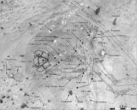
A final blast from ye olde past at Spirit's site... I've pretty much finished the image part of Spirit's journey and I'm working on the sol-by-sol text. This is a close view of the main targets of study at Troy before the end of the mission. Much more information on target names and locations will be released soon and I will be adding to the existing maps where appropriate. Meanwhile mapping is beginning at Meridiani.
Phil
-------------------- ... because the Solar System ain't gonna map itself.
Also to be found posting similar content on https://mastodon.social/@PhilStooke Maps for download (free PDF: https://upload.wikimedia.org/wikipedia/comm...Cartography.pdf NOTE: everything created by me which I post on UMSF is considered to be in the public domain (NOT CC, public domain) |
|
|
|
|
|
|
May 27 2012, 05:55 PM
Post
#22
|
||
|
Solar System Cartographer Group: Members Posts: 10229 Joined: 5-April 05 From: Canada Member No.: 227 |
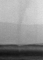
One other goodie. On sol 620 Spirit was on the summit of Husband Hill, taking a big panorama. This subframe is looking due east with three horizons visible - the near rim of Thira crater, the far rim of Thira, and in the distance the rim of Gusev itself. And in front of Thira is a towering dust devil. We normally see these DD images with the sky brightened enough to reveal the DD on the ground, overexposing anything in the sky. Here (from the 16 bit data) is the full vertical extent (cropped by the top of the frame). I found it while making a full mosaic of the rim of Gusev.
Phil
-------------------- ... because the Solar System ain't gonna map itself.
Also to be found posting similar content on https://mastodon.social/@PhilStooke Maps for download (free PDF: https://upload.wikimedia.org/wikipedia/comm...Cartography.pdf NOTE: everything created by me which I post on UMSF is considered to be in the public domain (NOT CC, public domain) |
|
|
|
|
|
|
Jun 3 2012, 03:36 PM
Post
#23
|
||
|
Solar System Cartographer Group: Members Posts: 10229 Joined: 5-April 05 From: Canada Member No.: 227 |
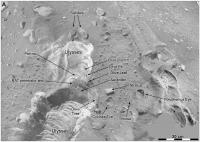
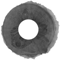
That last image was from a new study of the rim of Gusev from the pan shot at Everest (Husband Hill Absolute Summit) on sols 620-622. Here is the full panorama turned into a circle. The rim of Gusev has been subjected to an extreme contrast enhancement relative to the near horizon, resulting in artifacts in places. But I think the distant rim has never been seen so fully. Clearer views of small parts of it were obtained from West Spur, but this is the best look at the whole thing. The processing was done from the 16 bit images at PDS. I am working on an identification of features and will post it later, but I think the most interesting thing is the view of the large flat-topped mesas south of the rover, at the supposed Ma'adim Vallis delta, and the hills beyond which extend up the valley a bit inside the breached crater New Plymouth. Vertical exaggeration at the horizon is 5.5x.
Phil
-------------------- ... because the Solar System ain't gonna map itself.
Also to be found posting similar content on https://mastodon.social/@PhilStooke Maps for download (free PDF: https://upload.wikimedia.org/wikipedia/comm...Cartography.pdf NOTE: everything created by me which I post on UMSF is considered to be in the public domain (NOT CC, public domain) |
|
|
|
|
|
|
Jun 3 2012, 04:34 PM
Post
#24
|
|
|
Senior Member Group: Members Posts: 3516 Joined: 4-November 05 From: North Wales Member No.: 542 |
Very nice Phil!
 As it happens I've recently been thinking back to some long ago discussion on who-knows-which thread about some even more distant horizon features that could be seen through a gap in the Gusev rim. Is that visible on this panorama? If so where, and if not where's the location? I would like to revisit the precise identity of what may have been the most distant features seen by either rover. I wasn't paying enough attention at the time, but I don't think it was nailed down as thoroughly as it could have been, or could be now with Google Earth Mars or James Canvin-type reverse polar plots, or pgrindrod inter-visibility charts. |
|
|
|
|
Jun 3 2012, 08:11 PM
Post
#25
|
|
|
Solar System Cartographer Group: Members Posts: 10229 Joined: 5-April 05 From: Canada Member No.: 227 |
I don't remember that. If it was seen before it should be seen here. Can anyone find that discussion?
Phil -------------------- ... because the Solar System ain't gonna map itself.
Also to be found posting similar content on https://mastodon.social/@PhilStooke Maps for download (free PDF: https://upload.wikimedia.org/wikipedia/comm...Cartography.pdf NOTE: everything created by me which I post on UMSF is considered to be in the public domain (NOT CC, public domain) |
|
|
|
|
Jun 3 2012, 08:52 PM
Post
#26
|
||
|
Solar System Cartographer Group: Members Posts: 10229 Joined: 5-April 05 From: Canada Member No.: 227 |
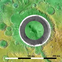
Sightlines plotted on a merge of THEMIS IR data (with inverted shading) and MOLA topography. This is a first attempt, but I may have to make some adjustments.
Phil (EDIT - replaced original with an improved version)
-------------------- ... because the Solar System ain't gonna map itself.
Also to be found posting similar content on https://mastodon.social/@PhilStooke Maps for download (free PDF: https://upload.wikimedia.org/wikipedia/comm...Cartography.pdf NOTE: everything created by me which I post on UMSF is considered to be in the public domain (NOT CC, public domain) |
|
|
|
|
|
|
Jun 3 2012, 09:14 PM
Post
#27
|
|
|
Senior Member Group: Members Posts: 3516 Joined: 4-November 05 From: North Wales Member No.: 542 |
It looks like it's on that line you've drawn at about half past five. If that's correct there's not much doubt about the identification. The horizon is one smaller crater-width further away. But how far is that? How does the distance compare with the Miyamoto rim peaks ('Mule Ears') seen by Opportunity?
Find the discussion - now that's a challenge. I'll have a go. |
|
|
|
|
Jun 3 2012, 09:47 PM
Post
#28
|
|
|
Senior Member Group: Members Posts: 3516 Joined: 4-November 05 From: North Wales Member No.: 542 |
Phil, can you put a scale on that image?
|
|
|
|
|
Jun 3 2012, 09:59 PM
Post
#29
|
|
 Senior Member Group: Members Posts: 4256 Joined: 17-January 05 Member No.: 152 |
There was some related discussion in this thread many many years ago...
|
|
|
|
|
Jun 3 2012, 11:06 PM
Post
#30
|
|
|
Solar System Cartographer Group: Members Posts: 10229 Joined: 5-April 05 From: Canada Member No.: 227 |
"Phil, can you put a scale on that image?"
Now I have replaced the previous image with one with a scale! Phil -------------------- ... because the Solar System ain't gonna map itself.
Also to be found posting similar content on https://mastodon.social/@PhilStooke Maps for download (free PDF: https://upload.wikimedia.org/wikipedia/comm...Cartography.pdf NOTE: everything created by me which I post on UMSF is considered to be in the public domain (NOT CC, public domain) |
|
|
|
|

|
Lo-Fi Version | Time is now: 26th September 2024 - 04:41 PM |
|
RULES AND GUIDELINES Please read the Forum Rules and Guidelines before posting. IMAGE COPYRIGHT |
OPINIONS AND MODERATION Opinions expressed on UnmannedSpaceflight.com are those of the individual posters and do not necessarily reflect the opinions of UnmannedSpaceflight.com or The Planetary Society. The all-volunteer UnmannedSpaceflight.com moderation team is wholly independent of The Planetary Society. The Planetary Society has no influence over decisions made by the UnmannedSpaceflight.com moderators. |
SUPPORT THE FORUM Unmannedspaceflight.com is funded by the Planetary Society. Please consider supporting our work and many other projects by donating to the Society or becoming a member. |
|