HRSC DEM Movies |

HRSC DEM Movies |
 Jan 6 2008, 07:55 PM Jan 6 2008, 07:55 PM
Post
#1
|
||
|
Founder  Group: Chairman Posts: 14432 Joined: 8-February 04 Member No.: 1 |
Thought I'd start a new thread for stuff done with the HRSC DEM's....
http://www.rlproject.com/HRSC/2039/2039_0000_flydown_hi.mov (8.3 meg) http://www.rlproject.com/HRSC/2039/2039_0000_flydown_lo.mov (3.0 meg)
|
|
 |
 
|
|
 |
|
Jan 9 2008, 12:31 AM
Post
#2
|
|||
|
Founder Group: Chairman Posts: 14432 Joined: 8-February 04 Member No.: 1 |
The texture for Eberswalde took for ever.
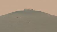
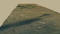
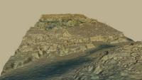
Just for you Nige - comparing 1x and 3x elevation at Nili Fossae (one of the MSL landing site proposals). Sat down, did the maths, made sure it was the right total altitude and that the difference between max and min altitiude matched the file headers. I've actually set both of these rendering in full. The problem is getting the cameras to match exactly. (you can stretch a terrain vertically quite easily, but not the path that a camera takes) so not the exact same view, but it's the same frame number from two very similar animations. You can probably guess which is the most accurate I can make to the actual, and which is 3x exag of that  For reference, this entire swath is 119.7km wide, 1059 km long - has a max altitude of -857m and a min altitude of -6866m (which I turn into adjusted altitiude based on the hrsc2tif idl module adding a value to make them all positive) - So a terrain altitude 'range' of 6 km from highest to lowest on the whole swath. i.e. 0.6% of the length - hence why they can be a bit dull. Those swath dimensions refer to this entire box in which the map projected image sits - http://pds-geosciences.wustl.edu/mex/mex-m...88_0000_gr3.jpg - I create an alpha channel for the terrain to remove the crap off the edges, as the displacement process goes nuts with the edge of the elevation map ( hence all the little funky jagged hedges around the edge of most of these ) Doug
Attached thumbnail(s)
|
||
|
|
|
||
 djellison HRSC DEM Movies Jan 6 2008, 07:55 PM
 djellison http://www.rlproject.com/HRSC/420_380/420_...lyaro... Jan 6 2008, 07:57 PM djellison http://www.rlproject.com/HRSC/446_438/446_438_flyd... Jan 6 2008, 07:58 PM
 ElkGroveDan I'm just speechless. Thanks for these Doug.
... Jan 6 2008, 08:05 PM djellison Some DEM's are cool, some not so great. Clou... Jan 6 2008, 11:10 PM djellison http://www.rlproject.com/HRSC/515/515_hi.mov (33.2... Jan 6 2008, 11:46 PM djellison This one (attached - Arsinoes Chaos ) and a very l... Jan 6 2008, 11:57 PM charborob Fantastic animations!
How much vertical exagg... Jan 7 2008, 03:08 AM djellison As I've said elsewhere, the vert exag is not a... Jan 7 2008, 07:41 AM djellison http://www.rlproject.com/HRSC/500/500_around_hi.mo... Jan 7 2008, 10:33 PM Bjorn Jonsson Even though I haven't downloaded all of these ... Jan 8 2008, 01:14 AM ngunn Just wanted to say how very much I appreciate thes... Jan 8 2008, 03:30 PM djellison I can change it very easily - and actually getting... Jan 8 2008, 05:53 PM ngunn QUOTE (djellison @ Jan 8 2008, 05:53 PM) ... Jan 8 2008, 08:23 PM Nix ! I was looking forward to something like this... Jan 8 2008, 06:24 PM djellison Yup - 3ds max, using the VRay renderer for displac... Jan 8 2008, 06:32 PM Nix Ah, THE mountain... I'm eager to see what... Jan 8 2008, 06:55 PM djellison http://hrscview.fu-berlin.de/cgi-bin/ion-p?page=en... Jan 8 2008, 09:59 PM djellison http://www.rlproject.com/HRSC/37/0037_ol_hi.mov (1... Jan 8 2008, 10:19 PM djellison Tonight - Eberswalde Crater with a CTX swathe on t... Jan 8 2008, 10:23 PM ElkGroveDan I think for maximum esthetic value you need someth... Jan 9 2008, 12:51 AM charborob QUOTE (ElkGroveDan @ Jan 8 2008, 07:51 PM... Jan 9 2008, 04:20 PM djellison This is the first frame + a middle-ish frame of th... Jan 9 2008, 01:05 AM ngunn Thanks Doug. So, EGD, Mars is too flat for ya? Jan 9 2008, 10:04 AM djellison And the HRSCView website will let you do that, to ... Jan 9 2008, 05:17 PM peter59 I'm sorry that I don't share your delight.... Jan 9 2008, 05:18 PM djellison QUOTE (peter59 @ Jan 9 2008, 05:18 PM) re... Jan 9 2008, 05:52 PM slinted QUOTE (djellison @ Jan 9 2008, 09:52 AM) ... Jan 9 2008, 06:14 PM TheChemist Not everybody has the time to scroll through HiRIS... Jan 10 2008, 10:03 AM Stu QUOTE (TheChemist @ Jan 10 2008, 10:03 AM... Jan 10 2008, 02:18 PM djellison http://www.rlproject.com/HRSC/988/988_1x_hi.mov (1... Jan 10 2008, 09:54 PM djellison http://www.rlproject.com/HRSC/511/511_ctx_hi.mov (... Jan 10 2008, 09:57 PM ngunn Superb, Doug. Gives a really good feel for the pla... Jan 11 2008, 12:34 PM djellison http://www.rlproject.com/HRSC/360_334/360_334_high... Jan 12 2008, 04:07 PM djellison http://www.rlproject.com/HRSC/360_334/360_334_low_... Jan 12 2008, 04:11 PM djellison I've done the full 511 swath. 720p, motion blu... Jan 25 2008, 11:04 PM elakdawalla Doug, is this the data you've already been usi... Feb 5 2008, 05:25 PM djellison That's a great big mosaic of DTM's - most ... Feb 5 2008, 05:47 PM cartrite Doug,
I've been following this thread for a wh... Feb 6 2008, 10:34 AM ngunn Doug, I've just seen your 'White Rock... Mar 28 2008, 11:47 AM djellison I'm annoyed that the DEM's that are availa... Mar 28 2008, 01:39 PM Sean Is it legal to resurrect a thread after 9 years?
... Apr 6 2017, 12:55 PM djellison This and that :-) Apr 6 2017, 03:46 PM Sean Tinto Vallis
Click thru for a video...
Blended... Apr 27 2017, 05:15 PM Sean Holden Crater
Video...
Portrait... Jun 19 2017, 12:28 PM Sean Mojave Flyby
4k version on Youtube Oct 19 2017, 04:00 PM
ElkGroveDan I'm just speechless. Thanks for these Doug.
... Jan 6 2008, 08:05 PM djellison Some DEM's are cool, some not so great. Clou... Jan 6 2008, 11:10 PM djellison http://www.rlproject.com/HRSC/515/515_hi.mov (33.2... Jan 6 2008, 11:46 PM djellison This one (attached - Arsinoes Chaos ) and a very l... Jan 6 2008, 11:57 PM charborob Fantastic animations!
How much vertical exagg... Jan 7 2008, 03:08 AM djellison As I've said elsewhere, the vert exag is not a... Jan 7 2008, 07:41 AM djellison http://www.rlproject.com/HRSC/500/500_around_hi.mo... Jan 7 2008, 10:33 PM Bjorn Jonsson Even though I haven't downloaded all of these ... Jan 8 2008, 01:14 AM ngunn Just wanted to say how very much I appreciate thes... Jan 8 2008, 03:30 PM djellison I can change it very easily - and actually getting... Jan 8 2008, 05:53 PM ngunn QUOTE (djellison @ Jan 8 2008, 05:53 PM) ... Jan 8 2008, 08:23 PM Nix ! I was looking forward to something like this... Jan 8 2008, 06:24 PM djellison Yup - 3ds max, using the VRay renderer for displac... Jan 8 2008, 06:32 PM Nix Ah, THE mountain... I'm eager to see what... Jan 8 2008, 06:55 PM djellison http://hrscview.fu-berlin.de/cgi-bin/ion-p?page=en... Jan 8 2008, 09:59 PM djellison http://www.rlproject.com/HRSC/37/0037_ol_hi.mov (1... Jan 8 2008, 10:19 PM djellison Tonight - Eberswalde Crater with a CTX swathe on t... Jan 8 2008, 10:23 PM ElkGroveDan I think for maximum esthetic value you need someth... Jan 9 2008, 12:51 AM charborob QUOTE (ElkGroveDan @ Jan 8 2008, 07:51 PM... Jan 9 2008, 04:20 PM djellison This is the first frame + a middle-ish frame of th... Jan 9 2008, 01:05 AM ngunn Thanks Doug. So, EGD, Mars is too flat for ya? Jan 9 2008, 10:04 AM djellison And the HRSCView website will let you do that, to ... Jan 9 2008, 05:17 PM peter59 I'm sorry that I don't share your delight.... Jan 9 2008, 05:18 PM djellison QUOTE (peter59 @ Jan 9 2008, 05:18 PM) re... Jan 9 2008, 05:52 PM slinted QUOTE (djellison @ Jan 9 2008, 09:52 AM) ... Jan 9 2008, 06:14 PM TheChemist Not everybody has the time to scroll through HiRIS... Jan 10 2008, 10:03 AM Stu QUOTE (TheChemist @ Jan 10 2008, 10:03 AM... Jan 10 2008, 02:18 PM djellison http://www.rlproject.com/HRSC/988/988_1x_hi.mov (1... Jan 10 2008, 09:54 PM djellison http://www.rlproject.com/HRSC/511/511_ctx_hi.mov (... Jan 10 2008, 09:57 PM ngunn Superb, Doug. Gives a really good feel for the pla... Jan 11 2008, 12:34 PM djellison http://www.rlproject.com/HRSC/360_334/360_334_high... Jan 12 2008, 04:07 PM djellison http://www.rlproject.com/HRSC/360_334/360_334_low_... Jan 12 2008, 04:11 PM djellison I've done the full 511 swath. 720p, motion blu... Jan 25 2008, 11:04 PM elakdawalla Doug, is this the data you've already been usi... Feb 5 2008, 05:25 PM djellison That's a great big mosaic of DTM's - most ... Feb 5 2008, 05:47 PM cartrite Doug,
I've been following this thread for a wh... Feb 6 2008, 10:34 AM ngunn Doug, I've just seen your 'White Rock... Mar 28 2008, 11:47 AM djellison I'm annoyed that the DEM's that are availa... Mar 28 2008, 01:39 PM Sean Is it legal to resurrect a thread after 9 years?
... Apr 6 2017, 12:55 PM djellison This and that :-) Apr 6 2017, 03:46 PM Sean Tinto Vallis
Click thru for a video...
Blended... Apr 27 2017, 05:15 PM Sean Holden Crater
Video...
Portrait... Jun 19 2017, 12:28 PM Sean Mojave Flyby
4k version on Youtube Oct 19 2017, 04:00 PM |

|
Lo-Fi Version | Time is now: 27th April 2024 - 03:04 PM |
|
RULES AND GUIDELINES Please read the Forum Rules and Guidelines before posting. IMAGE COPYRIGHT |
OPINIONS AND MODERATION Opinions expressed on UnmannedSpaceflight.com are those of the individual posters and do not necessarily reflect the opinions of UnmannedSpaceflight.com or The Planetary Society. The all-volunteer UnmannedSpaceflight.com moderation team is wholly independent of The Planetary Society. The Planetary Society has no influence over decisions made by the UnmannedSpaceflight.com moderators. |
SUPPORT THE FORUM Unmannedspaceflight.com is funded by the Planetary Society. Please consider supporting our work and many other projects by donating to the Society or becoming a member. |
|