Atop/Around the Greenheugh Pediment, Site 79-, sol 2695-3199, 3 Mar 2020-6 Aug 2021 |

  |
Atop/Around the Greenheugh Pediment, Site 79-, sol 2695-3199, 3 Mar 2020-6 Aug 2021 |
 Jan 22 2021, 12:14 AM Jan 22 2021, 12:14 AM
Post
#466
|
||
|
Junior Member  Group: Members Posts: 95 Joined: 11-January 07 From: Amsterdam Member No.: 1584 |
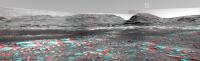
Sol 3008 rapid anaglyph.
-------------------- |
|
 |
 
|
|
|
Jan 22 2021, 12:17 AM
Post
#467
|
||
 Senior Member Group: Members Posts: 2425 Joined: 30-January 13 From: Penang, Malaysia. Member No.: 6853 |
A quick and dirty R-NavCam from 3008 using MS-ICE
|
|
|
|
|
|
|
Jan 22 2021, 03:23 PM
Post
#468
|
||
|
Senior Member Group: Members Posts: 2817 Joined: 22-April 05 From: Ridderkerk, Netherlands Member No.: 353 |
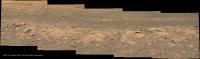
The NAVcam L view on Sol 3008.
Jan van Driel
|
|
|
|
|
|
|
Jan 22 2021, 10:04 PM
Post
#469
|
|||
|
Solar System Cartographer Group: Members Posts: 10146 Joined: 5-April 05 From: Canada Member No.: 227 |
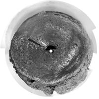
Jan's last two panoramas in circular format:
3005
3008
Phil -------------------- ... because the Solar System ain't gonna map itself.
Also to be found posting similar content on https://mastodon.social/@PhilStooke NOTE: everything created by me which I post on UMSF is considered to be in the public domain (NOT CC, public domain) |
||
|
|
|
||
|
Jan 22 2021, 10:20 PM
Post
#470
|
||
|
Founder Group: Chairman Posts: 14431 Joined: 8-February 04 Member No.: 1 |
There was also a mid-drive Navcam 360 on the 3008 drive.
Attached thumbnail(s)
|
|
|
|
|
|
|
Jan 23 2021, 04:33 PM
Post
#471
|
||
|
Senior Member Group: Members Posts: 1074 Joined: 21-September 07 From: Québec, Canada Member No.: 3908 |
Sol 3008 Lmastcam:
|
|
|
|
|
|
|
Jan 24 2021, 12:18 AM
Post
#472
|
||
|
Solar System Cartographer Group: Members Posts: 10146 Joined: 5-April 05 From: Canada Member No.: 227 |
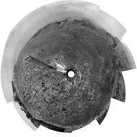
Doug's mid-drive panorama in circular format. There is an offset at about the 1:00 position in this image which affects the horizon, but otherwise it looks good.
Phil
-------------------- ... because the Solar System ain't gonna map itself.
Also to be found posting similar content on https://mastodon.social/@PhilStooke NOTE: everything created by me which I post on UMSF is considered to be in the public domain (NOT CC, public domain) |
|
|
|
|
|
|
Jan 24 2021, 04:20 AM
Post
#473
|
||
|
Senior Member Group: Members Posts: 1074 Joined: 21-September 07 From: Québec, Canada Member No.: 3908 |
Another sol 3008 partial panorama:
|
|
|
|
|
|
|
Jan 25 2021, 03:38 PM
Post
#474
|
||
|
Senior Member Group: Members Posts: 2817 Joined: 22-April 05 From: Ridderkerk, Netherlands Member No.: 353 |
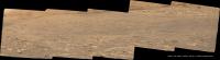
The NAVcam L view on Sol 3011.
Jan van Driel
|
|
|
|
|
|
|
Jan 25 2021, 10:05 PM
Post
#475
|
||
|
Solar System Cartographer Group: Members Posts: 10146 Joined: 5-April 05 From: Canada Member No.: 227 |
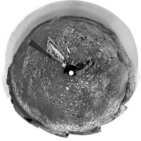
Charborob - very nice. Those rounded hills would be the Cromalt Hills, about 300 m north of the rover when the images were taken.
Jan - very nice too. Here is a circular version. The Cromalt Hills are at the 11 0'clock position. Phil
-------------------- ... because the Solar System ain't gonna map itself.
Also to be found posting similar content on https://mastodon.social/@PhilStooke NOTE: everything created by me which I post on UMSF is considered to be in the public domain (NOT CC, public domain) |
|
|
|
|
|
|
Jan 26 2021, 02:15 PM
Post
#476
|
||
|
Senior Member Group: Members Posts: 1074 Joined: 21-September 07 From: Québec, Canada Member No.: 3908 |
Sol 3011 Lmastcam:
|
|
|
|
|
|
|
Jan 26 2021, 03:09 PM
Post
#477
|
|
|
Senior Member Group: Members Posts: 2425 Joined: 30-January 13 From: Penang, Malaysia. Member No.: 6853 |
Looks like I have found where I can find the rover drive elevations that matches the elevations shown on the 1 meter contour lines that we used to get in the inset of the traverse maps that are sadly no longer being published. These can be found on a file called 'Rover Path.geojson' that can be downloaded from the interactive 'Where is the Rover' location map. It's a lengthy text file that shows the entire path from landing of the rover with breaks at the waypoints until the most recent sol at the end. It appears to provide Planetocentric longitude and latitude to 6 decimal places, as well as elevation in meters. It shows the elevation at the start of the drive, all the major changes in direction along the path and and the elevation at the end of the drive.
Here is the data for the Sol 3011 drive:- longitude, latitude, elevation (m) [137.401164,-4.733507,-4083.785149] beginning of drive (Sol 3011) [137.401187,-4.733513,-4083.649829] [137.401186,-4.733512,-4083.663368] [137.401256,-4.733444,-4083.587848] [137.401361,-4.733354,-4083.858619] [137.401543,-4.733399,-4083.471174] [137.401612,-4.733421,-4083.353024] [137.401722,-4.733464,-4082.510595] [137.401895,-4.733549,-4081.218448]end-of-drive (Sol 3011) I compared the elevations on a selection of a few end-of-drive locations that were recorded on the 'archived' traverse maps, and there appeared to be a perfect match for the elevation values annotated adjacent to each of the contour lines on the old traverse maps. I've been trawling through the SPICE/NAIF kernels to try and find a match to this elevation, sadly without any success so far. I can only find values that are out of step with those in the "Rover Path.Geojason" file, often by many 10's of meters. I believe that is because of the different ways of calculating the rovers location/elevation. Still digging... Lots more to read... Paul |
|
|
|
|
Jan 27 2021, 07:32 AM
Post
#478
|
||
|
Senior Member Group: Members Posts: 2425 Joined: 30-January 13 From: Penang, Malaysia. Member No.: 6853 |
Sol 3013 drive, roughly assembled R-NavCam partial pan, that way help to provide a clue or two regarding the location until the updated SPICE NAIF files come down.
It's not much, but it's the best MS Ice could do with the few raw images.
|
|
|
|
|
|
|
Jan 27 2021, 06:15 PM
Post
#479
|
|||
 Member Group: Members Posts: 219 Joined: 14-November 11 From: Washington, DC Member No.: 6237 |
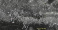
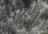
QUOTE (PaulH51 @ Jan 26 2021, 10:09 AM)  Looks like I have found where I can find the rover drive elevations that matches the elevations shown on the 1 meter contour lines that we used to get in the inset of the traverse maps that are sadly no longer being published. ... Been following along and this is the info I needed! Was able to finish putting together a basic 1m contour traverse map that seems to match the old ones... manually added contour labels and no coordinates shown but I think the data is right since I used the PDS basemap and DEM per the SIS that @mcaplinger pointed us to. Here's hoping it's of use in easing your pain:
Note that there is a small "seam" in the DEM that causes the vertical row of jagged contours just east of sol 3011 position. Will be interesting to see if there is any adjustment in the data as they've passed it. (I'm not a regular GIS user so please sanity check me - this snip near sol 2933 should match the inset from the traverse map here. If so, any future ones or updates will go in the map thread.)
|
||
|
|
|
||
|
Jan 27 2021, 09:35 PM
Post
#480
|
||
|
Senior Member Group: Members Posts: 2817 Joined: 22-April 05 From: Ridderkerk, Netherlands Member No.: 353 |
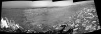
The NAVCam L view on Sol 3013.
Jan van Driel
|
|
|
|
|
|
|

|
Lo-Fi Version | Time is now: 19th April 2024 - 06:22 AM |
|
RULES AND GUIDELINES Please read the Forum Rules and Guidelines before posting. IMAGE COPYRIGHT |
OPINIONS AND MODERATION Opinions expressed on UnmannedSpaceflight.com are those of the individual posters and do not necessarily reflect the opinions of UnmannedSpaceflight.com or The Planetary Society. The all-volunteer UnmannedSpaceflight.com moderation team is wholly independent of The Planetary Society. The Planetary Society has no influence over decisions made by the UnmannedSpaceflight.com moderators. |
SUPPORT THE FORUM Unmannedspaceflight.com is funded by the Planetary Society. Please consider supporting our work and many other projects by donating to the Society or becoming a member. |
|