Venera Images, VENERA 13 fully calibrated image |

  |
Venera Images, VENERA 13 fully calibrated image |
 Oct 8 2010, 08:46 PM Oct 8 2010, 08:46 PM
Post
#121
|
|
|
Solar System Cartographer  Group: Members Posts: 10145 Joined: 5-April 05 From: Canada Member No.: 227 |
Good suggestion, but the areas covered by these reprojected images would span at most a few tens of pixels in Magellan images, and at locations in the images uncertain by many tens of kilometers, so it is very unlikely that we could do something like that.
Phil -------------------- ... because the Solar System ain't gonna map itself.
Also to be found posting similar content on https://mastodon.social/@PhilStooke NOTE: everything created by me which I post on UMSF is considered to be in the public domain (NOT CC, public domain) |
 |
 
|
|
Oct 9 2010, 07:00 PM
Post
#122
|
||
 Senior Member Group: Members Posts: 1079 Joined: 19-February 05 From: Close to Meudon Observatory in France Member No.: 172 |
QUOTE (sariondil @ Oct 2 2010, 02:37 PM)  A collection of surface panoramas: 180° for Venera 9 and 10, 360° for Venera 13 and 14. Reprojections are according to various suggestions on this forum. Horizon topography is probably not real, but due to inaccuracies of the reprojections (which are not strictly geometric anyway). Thanks for your contribution. You did an interesting work. The horizon of Venera 9 should be adjusted because the lander was sitting on a slope with a 20° tilt...

|
|
|
|
|
|
|
Oct 10 2010, 12:57 AM
Post
#123
|
|
|
Member Group: Members Posts: 378 Joined: 21-April 05 From: Portugal Member No.: 347 |
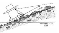
It's not easy to extrapolate much from the Venera images. I'm yet to see a good geometrical correction of all the distortions.
Those "U" shaped strips are approximations, and looking at them I always have the feeling that the spacecraft is on lower ground relating to the horizon. The imaging system is similar to that of Viking, but the scanning is made at an angle in relation to the horizon. The Venera cameras were about 2m above the surface but, as you move from the center to the edges towards the horizon, the image looks like they were taken with a lower point of view (more like Pathfinder). All of this makes the horizon interpretation much harder. What looks like a slope might be an horizontal feature... -------------------- _______________________
www.astrosurf.com/nunes |
|
|
|
|
Jul 21 2014, 03:22 AM
Post
#124
|
|
 Senior Member Group: Members Posts: 1417 Joined: 26-July 08 Member No.: 4270 |
Ted Stryk has given the Venera 9 and 10 images a bit of a makeover.
http://planetimages.blogspot.com/2014/07/s...us-in-1975.html -------------------- -- Hungry4info (Sirius_Alpha)
|
|
|
|
|
Jul 21 2014, 03:31 AM
Post
#125
|
|
|
Senior Member Group: Members Posts: 2075 Joined: 13-February 10 From: Ontario Member No.: 5221 |
Good catch! Why did I never notice the hills at Venera 9....
|
|
|
|
|
Jul 21 2014, 09:03 AM
Post
#126
|
|
|
Member Group: Members Posts: 378 Joined: 21-April 05 From: Portugal Member No.: 347 |
Interesting results with those horizon features.
 My only fear is that the results look too good. Easy to mistake the generated images for the actual ones... Other than that, I still see some geometric distortion in the vertical axis. But I know from self experience that this is a difficult dataset. -------------------- _______________________
www.astrosurf.com/nunes |
|
|
|
|
Jul 21 2014, 04:06 PM
Post
#127
|
|
 Interplanetary Dumpster Diver Group: Admin Posts: 4404 Joined: 17-February 04 From: Powell, TN Member No.: 33 |
QUOTE (4th rock from the sun @ Jul 21 2014, 09:03 AM) Interesting results with those horizon features. My only fear is that the results look too good. Easy to mistake the generated images for the actual ones... Other than that, I still see some geometric distortion in the vertical axis. But I know from self experience that this is a difficult dataset. The problem is that there are less that 50,000 pixels showing the surface, and so I used somewhat distorted repeats to fill gaps in the case of Venera 9. The hills to the left can be seen at the edge of the original panorama. Many versions I've seen have the horizons so overexposed that the hills are lost. The middle hill is of course a creation created from cloned bits of the stuff on either corner...here was my thinking...there are relatively big hills on the left, and the ground is choppy on the right-hand horizon. Venera-9 is itself on a slope. So there is little chance that the horizon is flat between the two corners of the panorama. It took dozens of times going back to the drawing board before I got something that looked half-way decent. Venera 10 was much easier. I was also trying to project it to look as though one is looking from one point rather than moving along the scene is the camera scanned...that improves some things, but creates other geometric issues. As I said, everything is from cloned portions of the actual image data. Nothing is drawn outright. That might be an interesting experiment. -------------------- |
|
|
|
|
Jul 22 2014, 10:20 AM
Post
#128
|
|
|
Member Group: Members Posts: 378 Joined: 21-April 05 From: Portugal Member No.: 347 |
The idea of providing a "synthetic" scene is interesting.
You could to the same using elements from earth photos. As long as rock size, distribution, overall shape and composition are the same, it's a valid experiment. I'd go for that and totally skip the original imagery. -------------------- _______________________
www.astrosurf.com/nunes |
|
|
|
|
Mar 5 2015, 05:34 PM
Post
#129
|
|
|
Interplanetary Dumpster Diver Group: Admin Posts: 4404 Joined: 17-February 04 From: Powell, TN Member No.: 33 |
Venera 14 landed 33 years ago today. I wrote a new blog entry about it. http://planetimages.blogspot.com/2015/03/v...hy-we-need.html
-------------------- |
|
|
|
|
Mar 5 2015, 05:43 PM
Post
#130
|
|
 Senior Member Group: Members Posts: 2530 Joined: 20-April 05 Member No.: 321 |
Very nice, Ted! Putting the images where they can be compared is very evocative. And yes, it's tantalizing to think of how much of Venus we haven't seen. One ground-buzzing airplane taking hi-definition video as it zoomed along a long ground swath could increase our ground-level imagery by a few orders of magnitude. If only the will were there...
|
|
|
|
|
Mar 5 2015, 05:54 PM
Post
#131
|
|
|
Interplanetary Dumpster Diver Group: Admin Posts: 4404 Joined: 17-February 04 From: Powell, TN Member No.: 33 |
QUOTE (JRehling @ Mar 5 2015, 05:43 PM) Very nice, Ted! Putting the images where they can be compared is very evocative. And yes, it's tantalizing to think of how much of Venus we haven't seen. One ground-buzzing airplane taking hi-definition video as it zoomed along a long ground swath could increase our ground-level imagery by a few orders of magnitude. If only the will were there... Thanks. I love the idea of a balloon that rises and falls with the day so that it touches down in multiple locations. I've added a second interpretation of the color in the combined image. -------------------- |
|
|
|
|
Mar 5 2015, 07:32 PM
Post
#132
|
|
|
Member Group: Members Posts: 362 Joined: 13-April 06 From: Malta Member No.: 741 |
It's time to go back and explore!
|
|
|
|
|
Oct 25 2015, 02:02 PM
Post
#133
|
|
 Member Group: Members Posts: 609 Joined: 23-February 07 From: Occasionally in Columbia, MD Member No.: 1764 |
My short paper just out in Icarus on the observed probability distribution of Venus surface winds (useful for lander design, as well as evaluation of aeolian transport) . It is remarkable that on only two ~hour long occasions when aeolian transport of regolith could possibly have been observed (by Venera landers), it was seen on one. Typically one has to wait months to see something happen on Earth or Mars - Venusian sediment is therefore probably always on the move, something that might be observable with radar interferometry, as well as lander observations...
(link to free pdf valid for 50 days) http://authors.elsevier.com/a/1RvsN4L-YESvT |
|
|
|
|
Oct 25 2015, 06:09 PM
Post
#134
|
|
|
Merciless Robot Group: Admin Posts: 8783 Joined: 8-December 05 From: Los Angeles Member No.: 602 |
Thanks for sharing this with us, Ralph. In your estimation, were the Veneras on the high or low side of optimum landing configuration (if that makes sense) given your analysis?
-------------------- A few will take this knowledge and use this power of a dream realized as a force for change, an impetus for further discovery to make less ancient dreams real.
|
|
|
|
|
Nov 3 2015, 02:45 PM
Post
#135
|
|
|
Member Group: Members Posts: 609 Joined: 23-February 07 From: Occasionally in Columbia, MD Member No.: 1764 |
QUOTE (nprev @ Oct 25 2015, 01:09 PM) In your estimation, were the Veneras on the high or low side of optimum landing configuration (if that makes sense) given your analysis? None of them fell over, so the design can be claimed to be robust. But the question of optimality is meaningless without a stated success criterion (i.e. given an [unknown] surface slope distribution and given an [unknown, but kindof handwavy-estimated here] wind distribution, and given a requirement for e.g. 99% success THEN a certain design can be considered optimal) The fundamental point is that any planetary landing entails uncertainty (qv Philae) and thus no finite-cost design can offer 100% reliability. Thus rational design and evaluation entails the statement of an acceptable degree of risk. Where terrain (or meteorological) factors introduce an entirely stochastic element to the landing dynamics, an optimal mission solution may be to build two 90% landers to achieve an overall 99% chance of safe landing. |
|
|
|
|

|
Lo-Fi Version | Time is now: 16th April 2024 - 07:01 PM |
|
RULES AND GUIDELINES Please read the Forum Rules and Guidelines before posting. IMAGE COPYRIGHT |
OPINIONS AND MODERATION Opinions expressed on UnmannedSpaceflight.com are those of the individual posters and do not necessarily reflect the opinions of UnmannedSpaceflight.com or The Planetary Society. The all-volunteer UnmannedSpaceflight.com moderation team is wholly independent of The Planetary Society. The Planetary Society has no influence over decisions made by the UnmannedSpaceflight.com moderators. |
SUPPORT THE FORUM Unmannedspaceflight.com is funded by the Planetary Society. Please consider supporting our work and many other projects by donating to the Society or becoming a member. |
|