MSL Post Landing - Commissioning Period & Early Observations, Commissioning Activity Period 1B - Sols 9 through 16 |

  |
MSL Post Landing - Commissioning Period & Early Observations, Commissioning Activity Period 1B - Sols 9 through 16 |
 Aug 24 2012, 01:01 AM Aug 24 2012, 01:01 AM
Post
#271
|
|
 Member  Group: Members Posts: 714 Joined: 3-January 08 Member No.: 3995 |
.
|
 |
 
|
|
Aug 24 2012, 04:13 AM
Post
#272
|
||
|
Member Group: Members Posts: 548 Joined: 19-March 05 From: Princeton, NJ, USA Member No.: 212 |
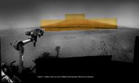
Our Mastcam color mosaic of Mount Sharp now added to our wider Navcam mosaic of robotic arm pointing to mountain; by Ken Kremer and Marco Di Lorenzo
Published at NBC News.com; story by Alan Boyle - thank you ! - - includes mountain mosaics by Stu and mention of UMSF "Curiosity adds color to Martian peak" http://photoblog.nbcnews.com/_news/2012/08...rtian-peak?lite
contrast enhanced to bring out detail - sol 2, 12, 13, 14 - Navcam and Mastcam raw images Ken Kremer ........ kenkremer.com |
|
|
|
|
|
|
Aug 24 2012, 07:06 AM
Post
#273
|
||
 Member Group: Members Posts: 404 Joined: 5-January 10 Member No.: 5161 |
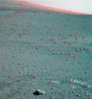
Destination: those distant hills! (After Glenelg, of course.) What a fantastic rolling landscape, which the anaglypgh captures a little here, like sea swells rolling in.
|
|
|
|
|
|
|
Aug 24 2012, 07:33 AM
Post
#274
|
||
|
Member Group: Members Posts: 404 Joined: 5-January 10 Member No.: 5161 |
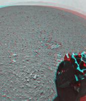
Like the first moon step, as someone already mentioned. The first roll:
Looks a little more compressed where it landed. |
|
|
|
|
|
|
Aug 24 2012, 11:54 AM
Post
#275
|
||
 Senior Member Group: Members Posts: 1465 Joined: 9-February 04 From: Columbus OH USA Member No.: 13 |
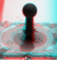
Curious to know how best to make stereo pairs from the mastcam images. The left image needs to be scaled and cropped to match the right--is using a constant scaling factor OK?
Mastcam 100 has been used for imaging some of the rover deck components but those are out of focus, presumably because the telephoto lens can't focus that close. Still, I tried an anaglyph of the sundial (sol 13, 12:42 p.m.) and it works to a first order, although the gnomon seems tilted toward the viewer:
It's interesting that the 3d effect comes out and appears fairly sharp even though the right eye is blurred. -------------------- |
|
|
|
|
|
|
Aug 24 2012, 01:51 PM
Post
#276
|
|
 Member Group: Members Posts: 699 Joined: 3-December 04 From: Boulder, Colorado, USA Member No.: 117 |
QUOTE (jmknapp @ Aug 24 2012, 05:54 AM)  It's interesting that the 3d effect comes out and appears fairly sharp even though the right eye is blurred. It's like the "monovision" contact lenses that some of us older folks have - different focus for each eye, but the brain can somehow combine the images and ignore the fact that one of them is out of focus. John |
|
|
|
|
Aug 24 2012, 03:14 PM
Post
#277
|
|
|
Member Group: Members Posts: 507 Joined: 10-September 08 Member No.: 4338 |
QUOTE (jmknapp @ Aug 24 2012, 03:54 AM) ... although the gnomon seems tilted toward the viewer: At that distance and left/right lens separation, the brain expects the eyes to be pointing inwards. In this case, a cross-eye stereo pair would work better for depth perception. Or with the anaglyph, put one's eyes really close to the screen. It is indeed very interesting that the brain can fuse the images in a way that takes the depth perception from both images and the sharpness from one image. In principle, an image-processing algorithm could do the same, i.e., use both images to construct the depth coordinate in a 3-dimensional rendering. Then map the left-eye pixels onto the 3D surface, and create a synthetic right eye view of the surface. |
|
|
|
|
Aug 24 2012, 03:44 PM
Post
#278
|
|
 Senior Member Group: Members Posts: 4246 Joined: 17-January 05 Member No.: 152 |
QUOTE (jmknapp @ Aug 24 2012, 11:54 AM) The left image needs to be scaled and cropped to match the right--is using a constant scaling factor OK? I've been wondering about that too. It'll depend on how they shoot the L/R pairs. We have pairs likehttp://mars.jpl.nasa.gov/msl-raw-images/ms...2000D1_DXXX.jpg http://mars.jpl.nasa.gov/msl-raw-images/ms...2000D1_DXXX.jpg The pointing hasn't changed, so I guess the L image must be cropped from the centre of the full L frame. If all L/R pairs are like this, then a constant scaling might be a good approximation. But if the L image is taken from off-centre, then the scaling will be somewhat different due to lens distortion. QUOTE (jmknapp @ Aug 24 2012, 11:54 AM) It's interesting that the 3d effect comes out and appears fairly sharp even though the right eye is blurred. Exactly. Actually I've made anaglyphs from nav/pancam pairs on MER before with similar success.
|
|
|
|
|
Aug 24 2012, 04:29 PM
Post
#279
|
|
|
Junior Member Group: Members Posts: 38 Joined: 14-August 12 Member No.: 6558 |
QUOTE (john_s @ Aug 23 2012, 11:17 AM) I think the lineations on the upper part are due to wind erosion, not primary layering- this is clearer in the orbital views. John Wouldn't the wind erosion tend to follow bedding? That's what you see with hoodoos and other wind-eroded features on the CO Plateau . . . . I agree with your later post, however, that these are probably cross-beds if "real". |
|
|
|
|
Aug 24 2012, 06:12 PM
Post
#280
|
|
|
Senior Member Group: Members Posts: 4246 Joined: 17-January 05 Member No.: 152 |
QUOTE (fredk @ Aug 24 2012, 03:44 PM) a constant scaling might be a good approximation On second thought, focus may change the relative scales of L and R cameras, so the scaling may depend on the distance to the target, even for central L crops.I'll miss the simplicity of MER pancam. (Until I see the mound with mastcam 100, that is!) |
|
|
|
|
Aug 24 2012, 07:03 PM
Post
#281
|
|
|
Junior Member Group: Members Posts: 26 Joined: 7-August 12 Member No.: 6485 |
QUOTE (Jaro_in_Montreal @ Aug 24 2012, 01:49 AM) Would anyone here happen to know roughly how deep the 0.4-millimeter hole in a typical basalt rock might be after 30 ChemCam laser shots ? How is that likely to change for clay or sulfate minerals ? Is there any risk of blowback of material from the hole into the ChemCam telescope ? ....is there a minimum distance to target to be respected ? Thanks. You might want to read this, which has a section where they test how deep the laser can penetrate. N165 was ~3m away and probably basalt, but they only used 30 pulses, so I'd guess it was a very shallow hole, maybe 50-100microns. The depth won't be linear with the number of pulses because as you get deeper more of the vapourised material will reform inside the hole. They did another test (Fig 27) which showed that it took over 10 pulses just to burn through a 25micron layer of dust. The plasma ball that's created is really very small, even in Mars atmosphere, so I doubt there's any danger. I suppose theoretically there might be some hazard if there were a loose grain right next to the laser site, but I suspect the real limit on how close they can get is determined by the minimum focus distance of the optics. |
|
|
|
|
Aug 24 2012, 07:12 PM
Post
#282
|
|
 Member Group: Members Posts: 112 Joined: 20-August 12 From: Spain Member No.: 6597 |
QUOTE (climber @ Aug 23 2012, 11:58 AM) Do you see several sort of land slides near the center? (no, I didn't say gullies) Hi to everybody, This is my first post in Unmanned Spaceflight and I wanted to say Hi in the first place and thanks for all your hard work analyzing all this data. Is incredible what we can achieve when we work together. Second, answering climber question, I think the feature we are seeing near the center of the image are some kind of debris apron or fan, at least in the MRO images I can't see any evidence of landslides in that zone, so it's easier to think that this feature is just the effect of erosion and transportation of sediments. Greetings! |
|
|
|
|
Aug 24 2012, 09:00 PM
Post
#283
|
|
 Junior Member Group: Members Posts: 66 Joined: 3-August 12 Member No.: 6454 |
QUOTE (charleski @ Aug 24 2012, 07:03 PM) You might want to read this, which has a section where they test how deep the laser can penetrate. N165 was ~3m away and probably basalt, but they only used 30 pulses, so I'd guess it was a very shallow hole, maybe 50-100microns. The depth won't be linear with the number of pulses because as you get deeper more of the vapourised material will reform inside the hole. They did another test (Fig 27) which showed that it took over 10 pulses just to burn through a 25micron layer of dust. The plasma ball that's created is really very small, even in Mars atmosphere, so I doubt there's any danger. I suppose theoretically there might be some hazard if there were a loose grain right next to the laser site, but I suspect the real limit on how close they can get is determined by the minimum focus distance of the optics. Thanks ! ...very interesting ! I also noted the following: QUOTE The pit diameter clearly decreases with depth to a small cross section near the deepest portion of the pit.... The requirement to profile >1 mm in rock samples was not conclusively met, as analyses with 1000 pulses stopped at <600 μm, though it is likely that 2000 pulses would have achieved the requirement. ....which seems to imply that the first ChemCam test, with 30 pulses, was nowhere near the number of pulses that will be commonly used later on during the mission: I was under the false impression that 30 pulses was not that far from the maximum per target ! |
|
|
|
|
Aug 24 2012, 10:09 PM
Post
#284
|
|
|
Member Group: Members Posts: 866 Joined: 15-March 05 From: Santa Cruz, CA Member No.: 196 |
This seems to imply the laser will rarely make it past the modified 'rind' on the exterior of most rocks, and may be more suited for investigating clean RAT holes. unless im wrong and didnt study the MER results closely enough i thought the 'rind' has lots of modified compounds in it over eons of weathering, not necessarily endemic to the rock.. (no im not a geo-areologist
 ) )EDIT: ohkey, section 7,8,9 of the document linked by charleski do go into some detial about it, still seems shallow depth but enough appraently to make these statements: QUOTE ...ChemCam is capable of observing weathering layers on rock targets, and, by removing this layer, determine the chemical composition of the underlying rock...
...ability to remotely remove dust and to study and remove weathering layers from rocks... |
|
|
|
|
Aug 24 2012, 10:47 PM
Post
#285
|
|
|
Merciless Robot Group: Admin Posts: 8783 Joined: 8-December 05 From: Los Angeles Member No.: 602 |
Nice part about that is the capability for before & after observations. Should prove illuminating either way.
-------------------- A few will take this knowledge and use this power of a dream realized as a force for change, an impetus for further discovery to make less ancient dreams real.
|
|
|
|
|

|
Lo-Fi Version | Time is now: 28th April 2024 - 03:28 PM |
|
RULES AND GUIDELINES Please read the Forum Rules and Guidelines before posting. IMAGE COPYRIGHT |
OPINIONS AND MODERATION Opinions expressed on UnmannedSpaceflight.com are those of the individual posters and do not necessarily reflect the opinions of UnmannedSpaceflight.com or The Planetary Society. The all-volunteer UnmannedSpaceflight.com moderation team is wholly independent of The Planetary Society. The Planetary Society has no influence over decisions made by the UnmannedSpaceflight.com moderators. |
SUPPORT THE FORUM Unmannedspaceflight.com is funded by the Planetary Society. Please consider supporting our work and many other projects by donating to the Society or becoming a member. |
|