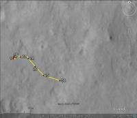
MSL Route Map |

  |
MSL Route Map |
 Sep 7 2012, 03:46 PM Sep 7 2012, 03:46 PM
Post
#16
|
|
 Junior Member  Group: Members Posts: 21 Joined: 21-August 12 From: the Netherlands Member No.: 6599 |
5 Sol 26 pictures in Google Earth Mars.......

. Google Earth KMZ file....
Attached File(s)
|
 |
 
|
|
Sep 7 2012, 04:13 PM
Post
#17
|
|
|
Junior Member Group: Members Posts: 59 Joined: 12-March 10 From: Austin, TX Member No.: 5262 |
VW, Thanks for that KML. Nothing I've seen better provides all the familiar images in their appropriate contexts. Very helpful to see just where everything is.
|
|
|
|
|
Sep 7 2012, 06:16 PM
Post
#18
|
|
|
Senior Member Group: Moderator Posts: 4279 Joined: 19-April 05 From: .br at .es Member No.: 253 |
Wow! I really, really, like it.
And welcome to UMSF, verfkwast. |
|
|
|
|
Sep 7 2012, 06:18 PM
Post
#19
|
|
 Member Group: Members Posts: 276 Joined: 11-December 07 From: Dar es Salaam, Tanzania Member No.: 3978 |
Here here! Excellent work verfkwast.
-------------------- |
|
|
|
|
Sep 8 2012, 04:31 AM
Post
#20
|
|
 Senior Member Group: Members Posts: 2228 Joined: 1-December 04 From: Marble Falls, Texas, USA Member No.: 116 |
I like it.
-------------------- ...Tom
I'm not a Space Fan, I'm a Space Exploration Enthusiast. |
|
|
|
|
Sep 8 2012, 04:34 PM
Post
#21
|
|
|
Junior Member Group: Members Posts: 21 Joined: 21-August 12 From: the Netherlands Member No.: 6599 |
.
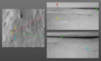
Update Googlle earth Rover overlays MSL Components +Rover tracks in Gale crater....... All 5 images placed + ballast
Attached File(s)
|
|
|
|
|
Sep 10 2012, 12:32 AM
Post
#22
|
|
|
Junior Member Group: Members Posts: 21 Joined: 21-August 12 From: the Netherlands Member No.: 6599 |
.
for who wants more ... Here's the 1st Full Crater Map for Google Earth it makes Google Mars a great tool to have some fun with Gale Crater . needs 2 gb memory & 600 mb diskspace Update 12/9: Easy install .
Attached File(s)
|
|
|
|
|
Sep 10 2012, 08:26 PM
Post
#23
|
|
|
Newbie Group: Members Posts: 8 Joined: 17-October 10 Member No.: 5494 |
Downloaded. The pixel size is about 10m.
|
|
|
|
|
Sep 10 2012, 11:01 PM
Post
#24
|
|
 Member Group: Members Posts: 136 Joined: 13-October 05 From: Malibu, CA Member No.: 527 |
QUOTE (Tesheiner @ Aug 31 2012, 10:36 AM)  Still testing... now with sol 24. [attachment=27823:Route_Map_Sol24.kml] Hi Tesh - it's been a long time since I have been able to visit here - and so glad to see that you're keeping up a good route-map! As usual. I'll be looking forward to your latest update on where this new rover is. Thanks much! I'm waaaay behind on the new interface, so hope my first post in years 'makes it'... 
|
|
|
|
|
Sep 15 2012, 08:54 AM
Post
#25
|
||
|
Senior Member Group: Moderator Posts: 4279 Joined: 19-April 05 From: .br at .es Member No.: 253 |
Here's my attempt at locating MSL on sol 38.
 Route_Map_Sol38.kmz ( 1.05K )
Number of downloads: 2187
Route_Map_Sol38.kmz ( 1.05K )
Number of downloads: 2187 |
|
|
|
|
|
|
Sep 17 2012, 04:03 PM
Post
#26
|
||
|
Junior Member Group: Members Posts: 31 Joined: 10-August 12 Member No.: 6526 |
I'll take a stab at Sol 41 based on the latest Navcams:
And a thumbtack:
Sol_41.kmz ( 720bytes )
Number of downloads: 2092Hopefully, I got it right...  Mark |
|
|
|
|
|
|
Sep 17 2012, 08:42 PM
Post
#27
|
||
|
Solar System Cartographer Group: Members Posts: 10229 Joined: 5-April 05 From: Canada Member No.: 227 |
Route map update...
I am fairly happy with all locations except the last one, which is very preliminary - originally I had it further south but I like Markril's estimate. All features of the map may be updated retroactively from time to time. Phil
EDIT: Looks like the last drive should be a bit shorter, and the one before a bit longer... I will be adding a scaled grid to this later. -------------------- ... because the Solar System ain't gonna map itself.
Also to be found posting similar content on https://mastodon.social/@PhilStooke Maps for download (free PDF: https://upload.wikimedia.org/wikipedia/comm...Cartography.pdf NOTE: everything created by me which I post on UMSF is considered to be in the public domain (NOT CC, public domain) |
|
|
|
|
|
|
Sep 18 2012, 05:43 AM
Post
#28
|
|
|
Member Group: Members Posts: 470 Joined: 24-March 04 From: Finland Member No.: 63 |
Thanks guys for the mapping effort. As I said in the other thread, the limited amount of available full resolution navcams all around the rover must make mapping challenging.
-------------------- Antti Kuosmanen
|
|
|
|
|
Sep 18 2012, 12:00 PM
Post
#29
|
|||
 Senior Member Group: Members Posts: 1465 Joined: 9-February 04 From: Columbus OH USA Member No.: 13 |
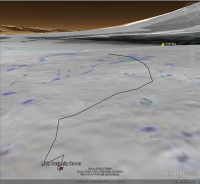
QUOTE (Phil Stooke @ Sep 17 2012, 04:42 PM) Route map update... I put that track into Google Earth--here's the overall view of the track as seen from a point about 25 meters above the landing spot:
Even from that vantage, Glenelg is slightly below the horizon. The ground image is the slope map. The track appears to go through some rougher terrain, so maybe it went around that a bit? Green is 12.5°-25° slope (no traverse on sand, some slip on bedrock). Here's the ground-level view from the terminal point:
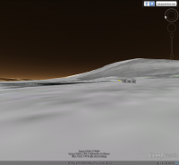
The pushpin for Glenelg is just peeking over the rise, so maybe it's not quite visible yet? GE elevation is based on MOLA and the "ground level" observation point in this case is from a height of 1.75 meters. Beeline range to Glenelg is about 190 meters, 170 meters to the landing site. KMZ file:
t40.kmz ( 1.46K )
Number of downloads: 2048-------------------- |
||
|
|
|
||
|
Sep 18 2012, 02:11 PM
Post
#30
|
||
|
Solar System Cartographer Group: Members Posts: 10229 Joined: 5-April 05 From: Canada Member No.: 227 |
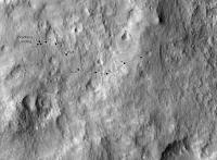
Revised route map for sol 41 - I had to revise the sol 40 point, which was difficult to match with HiRISE.
Phil
-------------------- ... because the Solar System ain't gonna map itself.
Also to be found posting similar content on https://mastodon.social/@PhilStooke Maps for download (free PDF: https://upload.wikimedia.org/wikipedia/comm...Cartography.pdf NOTE: everything created by me which I post on UMSF is considered to be in the public domain (NOT CC, public domain) |
|
|
|
|
|
|

|
Lo-Fi Version | Time is now: 27th September 2024 - 06:16 AM |
|
RULES AND GUIDELINES Please read the Forum Rules and Guidelines before posting. IMAGE COPYRIGHT |
OPINIONS AND MODERATION Opinions expressed on UnmannedSpaceflight.com are those of the individual posters and do not necessarily reflect the opinions of UnmannedSpaceflight.com or The Planetary Society. The all-volunteer UnmannedSpaceflight.com moderation team is wholly independent of The Planetary Society. The Planetary Society has no influence over decisions made by the UnmannedSpaceflight.com moderators. |
SUPPORT THE FORUM Unmannedspaceflight.com is funded by the Planetary Society. Please consider supporting our work and many other projects by donating to the Society or becoming a member. |
|