Spirit Route Map, Small and Large Scales |

  |
Spirit Route Map, Small and Large Scales |
 Nov 14 2005, 05:16 PM Nov 14 2005, 05:16 PM
Post
#166
|
|
|
Founder  Group: Chairman Posts: 14431 Joined: 8-February 04 Member No.: 1 |
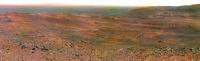
I was ASTONISHED by the Sol 659 drive - you can not see two sets of tracks, they must have backed up straight over the orig ones...astonishing driving
 Doug |
 |
 
|
|
Nov 14 2005, 05:21 PM
Post
#167
|
|
 Member Group: Members Posts: 257 Joined: 18-December 04 Member No.: 123 |
Seems like they have taken a leaf out of dilo's book in "Route mapping for MERs" with their polar projection type bit.
-------------------- Turn the middle side topwise....TOPWISE!!
|
|
|
|
|
Nov 16 2005, 02:30 AM
Post
#168
|
||
 Senior Member Group: Members Posts: 1887 Joined: 20-November 04 From: Iowa Member No.: 110 |
On the south side of the ridge now
|
|
|
|
|
|
|
Nov 16 2005, 02:57 AM
Post
#169
|
||
 Senior Member Group: Moderator Posts: 2262 Joined: 9-February 04 From: Melbourne - Oz Member No.: 16 |
QUOTE (alan @ Nov 16 2005, 01:30 PM) On the south side of the ridge now
 Good to see your location images back Alan. 
-------------------- |
|
|
|
|
|
|
Nov 18 2005, 03:59 AM
Post
#170
|
||
|
Senior Member Group: Members Posts: 1887 Joined: 20-November 04 From: Iowa Member No.: 110 |
Now in color
updated to sol 667 This post has been edited by alan: Nov 19 2005, 06:39 PM |
|
|
|
|
|
|
Nov 19 2005, 06:58 PM
Post
#171
|
||
|
Senior Member Group: Members Posts: 1887 Joined: 20-November 04 From: Iowa Member No.: 110 |
Orbital view
|
|
|
|
|
|
|
Nov 19 2005, 11:42 PM
Post
#172
|
|
 Member Group: Members Posts: 656 Joined: 20-April 05 From: League City, Texas Member No.: 285 |
Looks like we ought to be making a sharp turn to the west sometime soon. That was a quick descent.
|
|
|
|
|
Nov 21 2005, 06:47 PM
Post
#173
|
||
|
Senior Member Group: Members Posts: 1887 Joined: 20-November 04 From: Iowa Member No.: 110 |
Update to 670
Actual position is probably a bit lower, behind ridge. |
|
|
|
|
|
|
Nov 23 2005, 05:23 PM
Post
#174
|
||
|
Senior Member Group: Moderator Posts: 4279 Joined: 19-April 05 From: .br at .es Member No.: 253 |
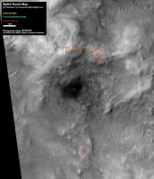
There was no update on Spirit traverse maps at the official MER webpage since sol 659 drive, and I wouldn't expect any until after Thanksgiving holidays.
So here is what I've been tracking until sol 671. Data until sol 651 have been adjusted to the official map while further positions up to sol 659 fits quite well with the traverse map.
|
|
|
|
|
|
|
Nov 23 2005, 05:28 PM
Post
#175
|
|
|
Solar System Cartographer Group: Members Posts: 10146 Joined: 5-April 05 From: Canada Member No.: 227 |
Tesheiner's map looks good to me, though I have not yet had a chance to compare it with my day to day notes.
Phil -------------------- ... because the Solar System ain't gonna map itself.
Also to be found posting similar content on https://mastodon.social/@PhilStooke NOTE: everything created by me which I post on UMSF is considered to be in the public domain (NOT CC, public domain) |
|
|
|
|
Nov 23 2005, 07:29 PM
Post
#176
|
|
|
Senior Member Group: Members Posts: 1887 Joined: 20-November 04 From: Iowa Member No.: 110 |
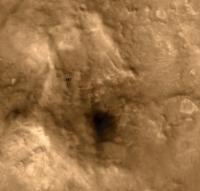
The nearest tracks from the sol 666 drive are 20 meters from Spirit's current position, so the sol 671 position should be about 20 meters to the SSW, near the edge of the dark patch.
|
|
|
|
|
Nov 23 2005, 08:16 PM
Post
#177
|
|
 Member Group: Members Posts: 578 Joined: 5-November 04 From: Denmark Member No.: 107 |
-------------------- "I want to make as many people as possible feel like they are part of this adventure. We are going to give everybody a sense of what exploring the surface of another world is really like"
- Steven Squyres |
|
|
|
|
Nov 23 2005, 09:17 PM
Post
#178
|
|
|
Senior Member Group: Moderator Posts: 4279 Joined: 19-April 05 From: .br at .es Member No.: 253 |
QUOTE (alan @ Nov 23 2005, 08:29 PM) The nearest tracks from the sol 666 drive are 20 meters from Spirit's current position, so the sol 671 position should be about 20 meters to the SSW, near the edge of the dark patch. I knew that when plotted 671 position; it was a bit inconsistent with that 666 drive. But that's the problem with this incremental method; errors are cumulative and from time to time you must correct the whole thing using another technic. |
|
|
|
|
Nov 24 2005, 01:19 AM
Post
#179
|
|
|
Member Group: Members Posts: 166 Joined: 20-September 05 From: North Texas Member No.: 503 |
QUOTE (dot.dk @ Nov 23 2005, 08:16 PM) Sorry ustrax. Ultreya is not in the "Corridor of Interest".  Why wouldn't Spirit as least give the area a brief up-close look? It sure seems interesting to me. |
|
|
|
|
Nov 24 2005, 02:33 AM
Post
#180
|
|
|
Solar System Cartographer Group: Members Posts: 10146 Joined: 5-April 05 From: Canada Member No.: 227 |
Dunes (drifts, ripples etc.) might be interesting if there were no other good targets around, but this is a geological wonderland rick in outcrops of rock of different types. The stuff of dunes could have come from anywhere, but bedrock is in place where it formed, full of clues about its depositional environment. It's going to be bedrock all, or most of, the time...
Phil -------------------- ... because the Solar System ain't gonna map itself.
Also to be found posting similar content on https://mastodon.social/@PhilStooke NOTE: everything created by me which I post on UMSF is considered to be in the public domain (NOT CC, public domain) |
|
|
|
|

|
Lo-Fi Version | Time is now: 19th April 2024 - 07:34 AM |
|
RULES AND GUIDELINES Please read the Forum Rules and Guidelines before posting. IMAGE COPYRIGHT |
OPINIONS AND MODERATION Opinions expressed on UnmannedSpaceflight.com are those of the individual posters and do not necessarily reflect the opinions of UnmannedSpaceflight.com or The Planetary Society. The all-volunteer UnmannedSpaceflight.com moderation team is wholly independent of The Planetary Society. The Planetary Society has no influence over decisions made by the UnmannedSpaceflight.com moderators. |
SUPPORT THE FORUM Unmannedspaceflight.com is funded by the Planetary Society. Please consider supporting our work and many other projects by donating to the Society or becoming a member. |
|