Crossing the Dunes at Murray Buttes, Sites 54-62, Sols 1353-1659, May 28 2016-Apr 6 2017 |

  |
Crossing the Dunes at Murray Buttes, Sites 54-62, Sols 1353-1659, May 28 2016-Apr 6 2017 |
 Jun 13 2016, 04:17 PM Jun 13 2016, 04:17 PM
Post
#61
|
|
|
Member  Group: Members Posts: 923 Joined: 10-November 15 Member No.: 7837 |
Here is a 3D model of Curi in situ on Sol 1357, scaled to HiRISE image of visit to Namib. Model includes notional route ahead.
This link will take you to the model on Sketchfab... Overview of Curi at Murray Buttes 
-------------------- |
 |
 
|
|
Jun 13 2016, 09:07 PM
Post
#62
|
|
 Senior Member Group: Members Posts: 2431 Joined: 30-January 13 From: Penang, Malaysia. Member No.: 6853 |
QUOTE (Phil Stooke @ Jun 14 2016, 12:03 AM)  Thanks Paul - I am completely reliant on our benefactors here on UMSF for panoramas. It did give a good location. Here's a reprojection, made at my B&B in Lyme Regis, Dorset while supposedly on holiday. Thanks for the reprojection and the new location map. Lyme Regis is a beautiful part of my old country. Hope you get chance to spend a little time at the 'Jurassic Coast' during your 'holiday'  |
|
|
|
|
Jun 13 2016, 09:11 PM
Post
#63
|
|
|
Senior Member Group: Members Posts: 2431 Joined: 30-January 13 From: Penang, Malaysia. Member No.: 6853 |
QUOTE (Sean @ Jun 14 2016, 12:17 AM) Here is a 3D model of Curi in situ on Sol 1357, scaled to HiRISE image of visit to Namib. Model includes notional route ahead. Really impressed with this Sean... Some breathtaking scenery lies ahead, and now I have a sense of the topography that the rover will travel through, I'm looking forward to the journey even more
|
|
|
|
|
Jun 13 2016, 09:14 PM
Post
#64
|
|
 Member Group: Members Posts: 706 Joined: 3-December 04 From: Boulder, Colorado, USA Member No.: 117 |
Well that's bizarre- I'm also on holiday in Lyme Regis. Haven't run into Phil, though, and I'm leaving early in the morning.
John |
|
|
|
|
Jun 13 2016, 10:01 PM
Post
#65
|
|
|
Solar System Cartographer Group: Members Posts: 10229 Joined: 5-April 05 From: Canada Member No.: 227 |
Hi John! I leave tomorrow too.
Phil -------------------- ... because the Solar System ain't gonna map itself.
Also to be found posting similar content on https://mastodon.social/@PhilStooke Maps for download (free PDF: https://upload.wikimedia.org/wikipedia/comm...Cartography.pdf NOTE: everything created by me which I post on UMSF is considered to be in the public domain (NOT CC, public domain) |
|
|
|
|
Jun 14 2016, 11:19 AM
Post
#66
|
||
|
Senior Member Group: Members Posts: 2431 Joined: 30-January 13 From: Penang, Malaysia. Member No.: 6853 |
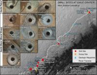
JPL have issued PIA20748 on its Photojournal page, it presents information relating to Curiosity's first 14 rock / soil sampling sites which are shown on a full traverse map.
I have attached the 'modest' version of the image. The full size image is available on this link and the catalog page: PIA20748 In addition to dates and site reference numbers for the activities, they have also provided the elevation data for the first 11 drill sites. I can't recall seeing that data in a release before, so it may be of interest to those who follow Curiosity's ongoing journey They also released 2 versions of the recent MAHLI self portrait at the 'Okoruso' drill site: see PIA20602 and PIA20603
|
|
|
|
|
|
|
Jun 14 2016, 01:16 PM
Post
#67
|
|
|
Senior Member Group: Members Posts: 2346 Joined: 7-December 12 Member No.: 6780 |
Nice synopsis of the drill holes!
The Oudam drill tailings look tinted to reddish, as a hint to a few percent of hematite abundance, again, and presumedly low in clay minerals. |
|
|
|
|
Jun 14 2016, 02:35 PM
Post
#68
|
||
|
Senior Member Group: Members Posts: 2872 Joined: 22-April 05 From: Ridderkerk, Netherlands Member No.: 353 |
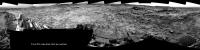
The complete Navcam L view on Sol 1369.
Jan van Driel
|
|
|
|
|
|
|
Jun 14 2016, 05:23 PM
Post
#69
|
||
|
Solar System Cartographer Group: Members Posts: 10229 Joined: 5-April 05 From: Canada Member No.: 227 |
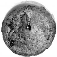
Thanks, Jan - here is a circular version, giving a good view of the surroundings.
And... where am I today? Eype's Mouth. It's where part of Broadchurch was filmed. Phil
-------------------- ... because the Solar System ain't gonna map itself.
Also to be found posting similar content on https://mastodon.social/@PhilStooke Maps for download (free PDF: https://upload.wikimedia.org/wikipedia/comm...Cartography.pdf NOTE: everything created by me which I post on UMSF is considered to be in the public domain (NOT CC, public domain) |
|
|
|
|
|
|
Jun 14 2016, 06:05 PM
Post
#70
|
||
 Senior Member Group: Members Posts: 4256 Joined: 17-January 05 Member No.: 152 |
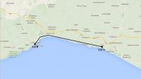
Phil route map for sol 1371:
The locations are probably good to within a couple of km, but the route is a complete guess until we can spot his tracks. Closeup maps with activities are pending...  
|
|
|
|
|
|
|
Jun 14 2016, 06:53 PM
Post
#71
|
|
|
Solar System Cartographer Group: Members Posts: 10229 Joined: 5-April 05 From: Canada Member No.: 227 |
Genius! But you're in the wrong thread...
Phil -------------------- ... because the Solar System ain't gonna map itself.
Also to be found posting similar content on https://mastodon.social/@PhilStooke Maps for download (free PDF: https://upload.wikimedia.org/wikipedia/comm...Cartography.pdf NOTE: everything created by me which I post on UMSF is considered to be in the public domain (NOT CC, public domain) |
|
|
|
|
Jun 14 2016, 10:02 PM
Post
#72
|
||
|
Senior Member Group: Members Posts: 2431 Joined: 30-January 13 From: Penang, Malaysia. Member No.: 6853 |
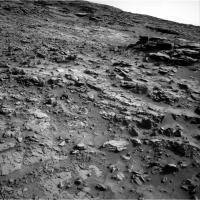
Curiosity Mission Update by Lauren Edgar, dated 13 Jun 2016, Sols 1371-1372: Driving south
QUOTE The weekend drive went well, and Curiosity drove ~ 32 m to the south. This southward path will eventually take us through a gap in the active sand dunes that will be easier for Curiosity to traverse. Were planning another drive today, which will take us in the direction of the above Navcam image. Todays two-sol plan consists of several ChemCam and Mastcam observations of the Murray formation to assess variations in texture and chemistry. We also planned a small Mastcam mosaic to document some nearby cross-stratification and nodules, and a small MAHLI mosaic of the target Berg Aukas before driving away. After the drive, well acquire our standard set of post-drive imaging for context and targeting. The second sol includes a small untargeted science block, which we filled with a ChemCam autonomously selected target and a Mastcam observation to monitor the opacity of the atmosphere.
|
|
|
|
|
|
|
Jun 15 2016, 02:58 PM
Post
#73
|
||
|
Senior Member Group: Members Posts: 2431 Joined: 30-January 13 From: Penang, Malaysia. Member No.: 6853 |
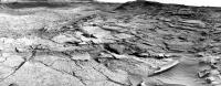
As planned a drive on sol 1371, only have a partial pan so far (cropped to fit)
MP still down, but Mr Knapp's page shows SSE by around 30 meters Hope this helps narrow down the location until Jan can post the full pan. Meanwhile its back to Falcon 9
|
|
|
|
|
|
|
Jun 15 2016, 03:59 PM
Post
#74
|
|
|
Solar System Cartographer Group: Members Posts: 10229 Joined: 5-April 05 From: Canada Member No.: 227 |
Alas, I think I need the Full Monty (AKA a 360 degree pan) to get this one.
Phil, now in Abbotsbury and quite exhausted. -------------------- ... because the Solar System ain't gonna map itself.
Also to be found posting similar content on https://mastodon.social/@PhilStooke Maps for download (free PDF: https://upload.wikimedia.org/wikipedia/comm...Cartography.pdf NOTE: everything created by me which I post on UMSF is considered to be in the public domain (NOT CC, public domain) |
|
|
|
|
Jun 15 2016, 08:46 PM
Post
#75
|
|
|
Member Group: Members Posts: 923 Joined: 10-November 15 Member No.: 7837 |
-------------------- |
|
|
|
|

|
Lo-Fi Version | Time is now: 27th September 2024 - 03:10 AM |
|
RULES AND GUIDELINES Please read the Forum Rules and Guidelines before posting. IMAGE COPYRIGHT |
OPINIONS AND MODERATION Opinions expressed on UnmannedSpaceflight.com are those of the individual posters and do not necessarily reflect the opinions of UnmannedSpaceflight.com or The Planetary Society. The all-volunteer UnmannedSpaceflight.com moderation team is wholly independent of The Planetary Society. The Planetary Society has no influence over decisions made by the UnmannedSpaceflight.com moderators. |
SUPPORT THE FORUM Unmannedspaceflight.com is funded by the Planetary Society. Please consider supporting our work and many other projects by donating to the Society or becoming a member. |
|