Printable Version of Topic
Click here to view this topic in its original format
Unmanned Spaceflight.com _ Chang'e program _ Chang'e 3 landing and first lunar day of operations
Posted by: Thorsten Denk Dec 2 2013, 10:01 AM
Interesting speculation by the LROC team about a possible landing place near crater Laplace A:
http://lroc.sese.asu.edu/news/index.php?/archives/828-A-Great-Place-to-Rove!.html
Chang'E/Yutu could land about 10km south east, then (the rover) cross a wrinkle-ridge and reach the rim of the 8km crater.
Thorsten (this is my first name, Denk is the family name)
Posted by: PaulH51 Dec 2 2013, 11:58 AM

...A Great Place to Rove!...
Welcome Thorsten

During the Chinese cntv.cn coverage the commentators disused the landing site : the 'Bay of Rainbows'. Sinus Iridum is Latin for "Bay of Rainbows"
Posted by: tolis Dec 2 2013, 09:09 PM
Looking at the lovely picture of Sinus Iridum a few posts back,
I wonder if the rim of the original crater is supposed to be
somewhere under the lava plain and whether the subsurface radar
of the rover could pick it up.
Posted by: Phil Stooke Dec 2 2013, 09:29 PM
Yes, it would be under the plains, but probably too deep to be detected. I am more interested in a different possibility - there's a bright/dark boundary between two different mare units, best seen in Clementine data (I posted a false color version higher up the thread). If they land near the boundary and drive over it they may be able to detect the underlying unit beneath the overlying one and get the thickness of the top unit. In fact they may get thichnesses of multiple flow units.
Phil
Posted by: Phil Stooke Dec 3 2013, 01:18 AM
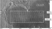
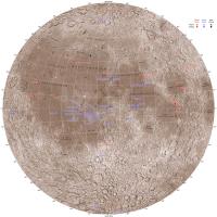
This map shows the extent of the landing region, extending quite far outside Sinus Iridum as well as inside it, and the coverage by Chang'E 2 at about 1.5 m/pixel. When we know where the landing will take place I will be adding more maps to zoom in on the site.
PS - for scale, 5 degrees of latitude is 150 km.
Phil
|
Posted by: Explorer1 Dec 3 2013, 03:13 AM
Planning a 'Yutu route map' sticky thread Phil? 
For what it's worth, the LROC team says they'll be photographing the site a few weeks after landing the 25th, January 22nd, and February 18th)
http://lroc.sese.asu.edu/news/index.php?/archives/828-A-Great-Place-to-Rove!.html#extended
Posted by: dvandorn Dec 3 2013, 05:37 AM
You know, that may not be a bad idea. Depending on the volume of images we get from the Chinese, it may be possible to follow the traverse somewhat real-time.
I would imagine we will have to wait to see if we get enough imagery to warrant it, but I'm beginning to think that we may need a dedicated Chang'e/Yutu folder, just as each of the Mars rovers has its own folder and LRO has its own folder, etc.
I am just on pins and needles waiting to see our first new lunar surface vista in decades!
-the other Doug
Posted by: Phil Stooke Dec 3 2013, 05:23 PM
I guess I wasn't subtle enough! Yes, I am planning to map the route - whether in its own thread or not, and that may depend on image access. I am collecting material for a new Moon atlas and this will be part of it.
I will rely very much on our very helpful Chinese contributors for pointing out new articles and other information, translating names of features in the landscape etc.
Phil
Posted by: RichforMars Dec 3 2013, 05:32 PM
This will be interesting. I remember seeing a long while ago the High definition video from the probe that went around the moon years ago. Good Stuff.
Posted by: dvandorn Dec 3 2013, 06:01 PM
With today's imaging technology, I'm hoping for HD video from the lander of the landing itself, and also of Yutu deployment and operations.
-the other Doug
Posted by: tolis Dec 3 2013, 07:45 PM
Phil
So, Chang'e/Yutu will be landing/roving on top of a geologic sandwich.
Posted by: Cosmic Penguin Dec 6 2013, 10:51 AM
Per latest Chinese reports:
Lunar landing is planned at 15:22-15:35 UTC on December 14.
The rover should be deployed from the lander at 20:38-22:21 UTC on the same day. Then some time within the communication window on December 15 at 07:21-15:38 UTC, the lander and rover will photograph each other and sing Moon River together during dating.
http://bjrb.bjd.com.cn/html/2013-12/02/content_130362.htm
Posted by: peter59 Dec 10 2013, 09:03 PM
At 9:24 pm, it was confirmed that Change-3 had entered the new orbit.
http://www.asianews.co/change-3-probe-moves-closer-to-the-moon/
It seems that all is well.
Posted by: Phil Stooke Dec 10 2013, 10:02 PM
Yes, only 15 km high at about 45 degrees north. Not long now.
Phil
Posted by: Phil Stooke Dec 12 2013, 02:43 PM
Time for a rather trivial prediction. Unless Chang'E 3 lands at the far eastern end of the mapped landing area, the mountain Promontorium Laplace will be visible on the horizon, barring small-scale local obstructions. That will help to give an idea of the location of the landing site quite quickly.
Phil
Posted by: charborob Dec 12 2013, 03:59 PM
According to my rough calculations, Promontorium Laplace should be visible from about 95km away. If Chang-e 3 lands near the mare ridge S-E of Laplace A, Prom. Laplace would barely be jutting above the horizon.
Posted by: kenny Dec 12 2013, 04:09 PM
Hardly trivial, Phil, given the time you have spent staring at hill tops to determine the uncertain location of Luna 9, in this same quadrant of the moon!
I look forward to seeing the summit of Promontorium Laplace on Saturday...
Posted by: kenny Dec 12 2013, 04:20 PM
This is orbital view of Promontorium Laplace taken by Apollo 15 from the South-South East (looking NNW), over the crater Helicon.
http://www.hq.nasa.gov/office/pao/History/ap15fj/photos/qq/as15-81-10976.jpg
Posted by: Thorsten Denk Dec 12 2013, 10:00 PM
Sunrise in Sinus Iridum!
I'm not an astrophotographer, but I couldn't resist to take some pictures.
(18:54 UTC, downsized to 50% and cropped, original http://ade.tdenk.de/2013/CIMG1314.JPG.)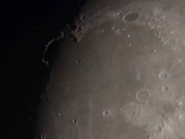
I was surprised how incredibly fascinating it is to be able
to see with my own eyes (and a 10"-Dobson) the operation area
of a human rover on another celestial body!
Laplace A and the wrinkle ridge were easily visible.
Go, Chang'E! Your landing area is now in sunlight!
Thorsten
Posted by: Phil Stooke Dec 12 2013, 10:05 PM
Very nice!
Joel Raupe, on http://lunarnetworks.blogspot.ca/ reports rumours that the landing site will be in the area shown here.
Phil
|
Posted by: Cosmic Penguin Dec 13 2013, 08:18 AM
Per latest Chinese reports the landing time has shifted to ~13:40 UTC (~8:40 am EST/5:40 am PST/9:40 pm in Beijing).
Posted by: craigmcg Dec 13 2013, 01:13 PM
Thanks Cosmic Penguin. Any update on the time coverage starts?
Posted by: pospa Dec 13 2013, 01:33 PM
and / or any published pictures from Moon orbit or the transfer?
Posted by: charborob Dec 13 2013, 01:59 PM
I would be surprised if there were any live coverage, considering how secretive the Chinese are. We'll get an announcement after the landing has occurred, and, I hope, a couple of pictures, but I'm not holding my breath.
Posted by: Thorsten Denk Dec 13 2013, 02:08 PM
Launch had a fantastic two-hours live coverage...
Posted by: kenny Dec 13 2013, 02:24 PM
I really don't think the Chinese are anything like as secretive as they once were. They showed great live coverage of launch and trans-lunar injection on TV.
They have announced in advance a revision of the landing time from 15:35 UTC to 13:40 UTC, so have brought it forward by one orbit.
I think there will be live or near-live coverage on Chinese CNTV. Although there is to be a descent imager snapping away as it lands, that is supposed
to be for planning rover routes, so I doubt if those will be streamed live, and will probably be sent back after the autonomous landing.
Posted by: SpaceListener Dec 13 2013, 05:01 PM
I suppose mostly as Kenny says. Sure Chinese government will announce and show with great detail if the mission was successful and a few words and no images if it fails. Hope that the Saturday would be a great day.
The Perilunar orbit of Change'e-3 is of polar orbit from south to north would be above of the Laplace crater at around 43:42 North & 26:56 West? or its perilunar would be at lower latitude such as by 30:00 North in order to take a braking trajectory before landing on Moon?
Posted by: kenny Dec 13 2013, 07:05 PM
Change 3 is now in an intermediate descent orbit of 15 x 100 km, which is of very similar altitude parameters to the descent orbit used by Apollo in the 1960s
and 70s. However, Change is attempting a landing out of a near-polar orbit (90 degrees inclination), which has never been performed before by any spacecraft.
According to Patrick Blau at Spaceflight101, about one hour ahead of the start of the landing sequence (i.e. half an orbit earlier on the far side of the moon),
Chang'e 3 makes an engine burn to further reduce its periselene altitude to just 2 km above Sinus Iridum. This is an extremely low orbit Apollo regarded a
powered descent start of lower than 16 km as a safety hazard, but I guess we know a lot more about mascons and their orbital perturbations now.
According to Astrogatorsguild web site, it seems the landing is on the southward-travelling portion of the orbit, so it will come in from over the North Pole and start its final
braking over Sinus Iridium. Then it will take 700 seconds from ignition at 2,000 metres altitude down to landing.
Lovely view of the moon this afternoon over Loch Ness, with the terminator already west of Sinus Iridium, and the bay and Promontory Laplace in sunlight,
ready and waiting...
Posted by: ollopa Dec 13 2013, 09:16 PM
Many thanks to Cosmic Penguin and others for the hard information. However, is it just me or is the S/N ratio deteriorating elsewhere on this thread?
A propos Phil's far-from-"trivial prediction": there may be something in the way of that view of Promontorium Laplace.
A fascinating paper (in Chinese, so I'm relying on the pictures) appeared last month in Scientia Sinica: "Geological features and magmatic activities history of Sinus Iridum".
http://phys.scichina.com:8083/sciG/EN/volumn/volumn_6746.shtml
I believe it is fair use to post the LRO/LOLA-based elevation map for the wrinkle ridge near where most people now think Chang'e will land.
|
That will be some view, come tomorrow evening, if................
Posted by: Astro0 Dec 14 2013, 05:00 AM
<ADMIN MODE>
From comments in a few recent posts, I just want to remind people to avoid making statements which may imply any political (and I mean that in its broadest sense) commentary about the merits or otherwise of the openness or otherwise of any particular nation's space program, government or media.
As with ANY mission, what data/images are released are a bonus to the public (that includes UMSF'ers) not a right.
</ADMIN MODE>
Just enjoy the ride.
Posted by: PaulH51 Dec 14 2013, 07:02 AM
Anyone aware of any plans to live stream any of the Chang'e landing process from its mission control center (similar to the launch)
Posted by: bobik Dec 14 2013, 07:04 AM

The two features labeled as "fuel tanks" are actually http://link.springer.com/article/10.1007%2Fs11431-013-5377-0 for pressurization of the pressure-fed propulsion system.
Posted by: Explorer1 Dec 14 2013, 07:05 AM
Any idea how low Earth will be in the sky to the cameras? Sinus Iridium is even farther from the sub-Earth point than Apollo 17 was, and I know it was lower in the sky from Taurus-Littrow than any of the other landing sites.
Also depends on how high the cameras can be pointed too!
Posted by: climber Dec 14 2013, 07:42 AM
Posted by: PaulH51 Dec 14 2013, 11:34 AM
Many thanks
Posted by: kenny Dec 14 2013, 12:19 PM
I estimate around 40 degrees above the horizon, based on the co-ordinates of the intended landing site.
Posted by: Astro0 Dec 14 2013, 12:29 PM
Live coverage is up and running on http://english.cntv.cn/live/p2p/index.shtml.

|
Posted by: nprev Dec 14 2013, 12:55 PM
Thanks, Astro0! (Stayed up all night since Ms. Nprev wanted a night on the town. Turns out that she can't drink NEARLY as much as me, so she's beddy-bye. Me, I GOT to see this happen!)
Posted by: Paolo Dec 14 2013, 12:55 PM
from the map they showed on CCTV it looks like CE3 is heading to the eastern edge of the landing site, and into Mare Imbrium, close to crater Le Verrier instead of Sinus Iridum
Posted by: Paolo Dec 14 2013, 12:59 PM
stealing borrowing a picture site from NASAspaceflight showing the targeted landing site

|
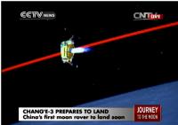
Posted by: Astro0 Dec 14 2013, 01:01 PM
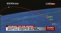
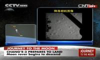
Chang'e 3 on final descent.
|
|
Posted by: nprev Dec 14 2013, 01:05 PM
Descent apparently proceeding well thus far. (Odd that there are also something like '7 minutes of terror' to do a lunar landing, just like a Mars landing...)
Posted by: jasedm Dec 14 2013, 01:08 PM
Heart in mouth time!
Good luck all!
Posted by: Hungry4info Dec 14 2013, 01:14 PM
Touchdown! A spacecraft is now transmitting data from the surface of the Moon!
Posted by: Astro0 Dec 14 2013, 01:14 PM
Touchdown!
Posted by: Seryddwr Dec 14 2013, 01:15 PM
A flawless landing as far as I can see. Well done all!
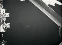
Posted by: PaulH51 Dec 14 2013, 01:16 PM
TD about 2 minutes ago...... Image of ground and part of a landing leg....
Posted by: Paolo Dec 14 2013, 01:16 PM
the rabbit has landed
in Mare Imbrium instead of Sinus Iridum
Posted by: nprev Dec 14 2013, 01:16 PM
That was SMOOTH, and had frame-by-frame descent imagery as well! Congratulations to the PRC!!!!!
Posted by: Astro0 Dec 14 2013, 01:17 PM
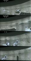
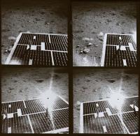
Images from the descent. Amazing. Too fast to get enough shots to animate.
Here's one frame at about 70 metres (?)
|
Posted by: tolis Dec 14 2013, 01:18 PM
And that, gentlemen, is how we do that..
Posted by: kenny Dec 14 2013, 01:19 PM
From the big screen in Mission Control, it seems to have landed some way to east of Promontorium Laplace -- to be expected, given
it has landed one orbit earlier than the original discussions.
Posted by: Ian R Dec 14 2013, 01:20 PM
GIF landing sequence:
http://postimg.org/image/l08n4q135/
Posted by: tolis Dec 14 2013, 01:22 PM
Someone correct me if I am wrong, but I think their landing further east than sinus iridum may
have something yo do with the fact that they chose to land earlier (by 1.5 hr) and therefore the moon
hadn't yet rotated sufficiently to align sinus iridum with the probe's trajectory.
Posted by: nprev Dec 14 2013, 01:22 PM
Gotta say that I'm pretty impressed. Hope that the rest of the mission goes even half this well because that was apparently a faultless descent.
Wow.
"We're BACK, baby!!!"
Posted by: Explorer1 Dec 14 2013, 01:23 PM
Woke up too late, thanks for the gif!
First surface images coming soon?
Posted by: tolis Dec 14 2013, 01:29 PM
Correction on previous: it's 3.5 hours earlier. The Moon would have (not) rotated an extra ~2 deg or 60 km.
Posted by: Astro0 Dec 14 2013, 01:32 PM
Last frame from descent camera.
|
Posted by: tolis Dec 14 2013, 01:47 PM
From the images taken from CCTV's live footage posted at the NASASpaceflight forum, it looks like it landed
near crater Laplace F, south of Montes Rectii.
Posted by: Paolo Dec 14 2013, 01:47 PM
59 pictures were sent back in real time
Posted by: Paolo Dec 14 2013, 01:51 PM
seems to be in a flat area of Mare Imbrium between Laplace F and le Verrier
Posted by: Explorer1 Dec 14 2013, 01:59 PM
Live coverage over for now. Replaying landing....
Posted by: Cosmic Penguin Dec 14 2013, 02:00 PM
The landing site is at 19.51 deg. West, 44.12 deg. North, per reports from the control center.
Posted by: Paolo Dec 14 2013, 02:06 PM
thank you. that is 20-30 km southeast of Laplace F
Posted by: kenny Dec 14 2013, 02:29 PM
Xinhua news agency has announced erroneously that Chang'e-3 landed on the moon's Sinus Iridum, or the Bay of Rainbows, at about 9:12 p.m. Saturday,
making China the third country in the world to carry out such a rover mission after the United States and former Soviet Union.
This is wrong location as the Mission Control panel screen showed it landing well to the east of Sinus Iridium, in Mare Imbrium.
My estimate of the landing coordinates, from the low-res screen, is in the area of 19 degrees West, 45 degrees North. That would put it about 25km SE
of the ~7km diameter crater Laplace F, near a ridge or scarp, and a couple of other craters of 2km diameter. So there might be some topography in view.
(written before previous announcements!)
Posted by: Paolo Dec 14 2013, 02:32 PM
where is Phill Stooke when we need him!
Posted by: dilo Dec 14 2013, 02:37 PM
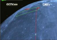
Looking to the following CNTV screenshot, it seems that actual landing point is the rightmost one in the green box, presumably showing the previously selected potential landing area...
|
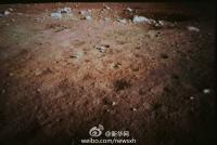
Posted by: Cosmic Penguin Dec 14 2013, 03:08 PM
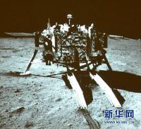
And the first image from the lander's monitoring camera.
(Source: Xinhua News Agency)
|
Posted by: ElkGroveDan Dec 14 2013, 03:38 PM
I don't suppose they named the descent camera 星期二 (Xīng qī èr)...
Posted by: volcanopele Dec 14 2013, 03:41 PM
Any chance the landing site is in an existing LROC frame?
Posted by: Phil Stooke Dec 14 2013, 04:01 PM
Very good chance, the whole area is blanketed with images, and Chinese scientists downloaded them all in that area (confirmed by LROC team) and will have chosen a site which is well imaged.
Phil
Posted by: Phil Stooke Dec 14 2013, 04:03 PM
"where is Phill Stooke when we need him!"
Good day for the home internet to go down! Also real life is getting in the way, but I should be back in my protective bubble soon.
Phil
Posted by: 4th rock from the sun Dec 14 2013, 04:42 PM
http://imageshack.us/photo/my-images/33/51t5.png/
I break my long hibernation from this group  to post a quick mosaic of some of the descent camera frames.
I corrected the proportions to have square craters.
There are some more distant frames that could cover a larger area.
Posted by: Hungry4info Dec 14 2013, 05:29 PM
Well, I've identified the landing site.
Lat: ~44.1260, Lon: ~-19.5014.
Using http://target.lroc.asu.edu/q3/ and matching it to several of the descent camera images.
See below.
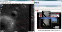
|

|
Posted by: mcaplinger Dec 14 2013, 05:38 PM
Wow, nice work. Seems convincing to me.
Posted by: Paolo Dec 14 2013, 05:49 PM
great work! so could the blocky crater we are seeing during the descent be the same one visible on that first surface pic?
Posted by: Hungry4info Dec 14 2013, 05:57 PM
I think the crater from the surface image is actually a smaller one nearer the landing site. You can see it (and boulders in it that correspond fairly well to the surface image) in like the last frame before landing.
Edit: After looking at it again, I'm less certain of this.
Posted by: kenny Dec 14 2013, 06:10 PM
This is the wider picture of the landing site, from Xinhua News Agency.
The crater which is 3 flag heights above the landing site is Laplace F.
The largest crater in the cluster to the west of the landing site is Laplace FA (at least, it is on my rather old Apollo-era US map).

|
Posted by: Hungry4info Dec 14 2013, 06:16 PM
Candidate surface feature identifications.

|
Posted by: Steve G Dec 14 2013, 06:30 PM
Hello Old Friend, Long time no see!
Posted by: Explorer1 Dec 14 2013, 06:44 PM
Looking at the video on Emily's blog post, that very first image after landing is a little blurry in the shadows; that must've been the dust not quite settled. They sharpen in the next one:
https://www.youtube.com/watch?v=xfNb0jeTi2s
From 12:00 to 12:33 you can see it soften!
Not quite Curiosity style, but still really impressive (and presumably more images will come down soon)!
Posted by: tolis Dec 14 2013, 06:48 PM
If the landing site ID posted by Hungry4info is correct,
the rover should find itself in a target-rich environment.
There are rocks and boulders of various sizes, especially along the rim of "the" large crater immediately to the west of the lander.
On the near side of that rim there is also a bright patch that may be ejecta from a small, fresh crater.
I wonder if the peaks of Montes Rectii are jutting above the N horizon Pole-Position style, ~100 km away.
That would be fun.
PS. The Pole-Position reference will only make sense to the more seasoned among you..
Posted by: Thorsten Denk Dec 14 2013, 06:51 PM
Interesting.
If you turn upside down (180deg) the picture at right (before landing),
and correct your assignment of "D", then it looks very convincing.
What size has this crater?
Thorsten
Posted by: Hungry4info Dec 14 2013, 06:58 PM
The crater is 20 metres across and about 20 metres from the lander. And yeah, my D is off. Thanks for the correction.
Posted by: Thorsten Denk Dec 14 2013, 08:29 PM
My "interpretation" of your findings.
Easier to see the coincidence.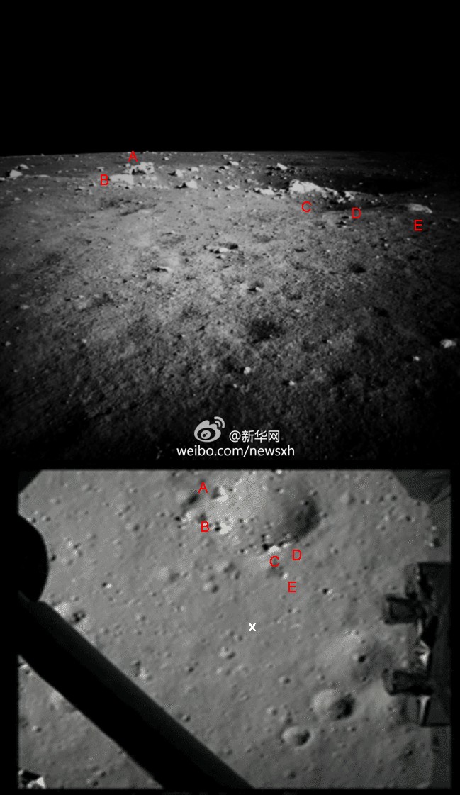
Thorsten
PD: North is up.
Posted by: Hungry4info Dec 14 2013, 08:47 PM
Nice work. That does make it easier to see!
Posted by: nprev Dec 14 2013, 09:02 PM
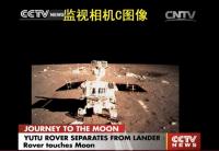
Live feed from CCTV just started; rover roll-off to occur shortly.
http://english.cntv.cn/live/p2p/index.shtml
UPDATE: CCTV reports Yutu rover on the surface! No imagery yet.
Posted by: Explorer1 Dec 14 2013, 09:11 PM
Ramps being shown; rover shadow on left!
It's driving onto the ramp!
Crane lowering! Surface in background!
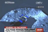
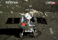
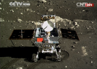
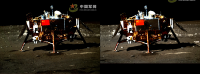
Posted by: Astro0 Dec 14 2013, 09:17 PM
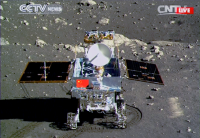
Yutu on the ramp being lowered to surface.

|
Posted by: Explorer1 Dec 14 2013, 09:19 PM
Six wheels on Moon! Tracks!
Posted by: Astro0 Dec 14 2013, 09:20 PM
|
Posted by: nprev Dec 14 2013, 09:24 PM
I watched the deployment (previously recorded). VERY interesting deployment method. Looked like it rolled forward onto the top of the ramp, which itself was subsequently lowered to contact the surface for roll-off. Don't we've seen a schema like that before.
Posted by: craigmcg Dec 14 2013, 09:26 PM
Great coverage. HD res update every second.
Posted by: Hungry4info Dec 14 2013, 09:27 PM
They showed the lander's area, presumably as imaged by the monitoring camera.
|
Posted by: Astro0 Dec 14 2013, 09:33 PM
Emily just posted an animation of Yutu driving onto the surface. As she says "Woohoo!".
http://www.planetary.org/blogs/emily-lakdawalla/2013/12141328-six-wheels-on-soil-for-yutu.html
Posted by: Paolo Dec 14 2013, 09:56 PM
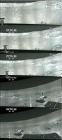
my friend Tezio from the French http://astronautique.actifforum.com/has authorized me to re-post here his amazing analysis of the landing trajectory of CE-3.
He assembled all the available images and took the center of each one, assuming the camera to be looking at the local vertical. The probe had no rotation at all. Only near the surface, it backed up and moved a bit to the right before touching down.
http://www.servimg.com/image_preview.php?i=2252&u=11505037
http://www.servimg.com/image_preview.php?i=2253&u=11505037
http://www.servimg.com/image_preview.php?i=2254&u=11505037
http://www.servimg.com/image_preview.php?i=2255&u=11505037
Posted by: kenny Dec 14 2013, 10:18 PM
Wonderful piece of work.... It looks like the edge of large crater just a few tens of metres to the west of the landing site.
Posted by: infocat13 Dec 14 2013, 10:20 PM
shadow on the left so rover is facing south?
Posted by: kenny Dec 14 2013, 10:24 PM
No, Rover drove off in the direction of north. Sun on right (east), and shadows on left (west) side.
Posted by: Phil Stooke Dec 14 2013, 10:25 PM
No, facing north. It's morning, the sun is in the east, the shadow points west.
Phil
Posted by: Explorer1 Dec 14 2013, 10:33 PM
Which means Earth is somewhere behind; apparently new images will coming in the next half day or so.
I'm wondering how far the rover will drive before nightfall; they might want to stay within site of the lander the first night....
Posted by: Astro0 Dec 14 2013, 10:46 PM
Removed the CCTV captions by overlaying lower part of frame and cropping
Larger version http://astro0.files.wordpress.com/2013/12/yutu_deploy.gif. 1.93mb
Posted by: infocat13 Dec 14 2013, 10:52 PM
Phil
Kenny and Phil thanks for un confusing me
Posted by: Vultur Dec 14 2013, 11:19 PM
Awesome! Wonderful to see it rolling on the Moon...
(and congratulations to the Chinese space program for this achievement...)
Posted by: Explorer1 Dec 15 2013, 12:04 AM
Are these new photos from Xinhua? They show both longer tracks than the TV coverage and a new view that looks a little lower to the surface (possibly from the rover cameras?)
https://twitter.com/XHNews/status/411999590443786240
Posted by: Hungry4info Dec 15 2013, 12:36 AM
The second image I saw on FB recently, but the third image is new to me. Thanks for that link.
Posted by: 4th rock from the sun Dec 15 2013, 12:50 AM
Those pictures are in somewhat higher quality here:
http://news.xinhuanet.com/english/photo/2013-12/15/c_132968376_5.htm
Posted by: Phil Stooke Dec 15 2013, 02:00 AM
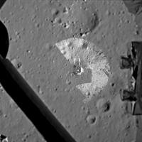
Going from a LROC-WAC mosaic to a NAC frame to a descent camera mosaic (from 4th Rock... welcome back!) - a locator guide to the site.
Phil
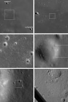
|
Posted by: Phil Stooke Dec 15 2013, 02:39 AM
And this is 4th Rock's mosaic with additions from one of the TV screenshots posted on NasaSpaceFlight. It is an overhead projection of the initial rover image mosaic, for planning purposes, superimposed with a lander model. This all took a bit of fudging, but it's a start at a site map.
Phil
|
Posted by: climber Dec 15 2013, 06:25 AM
So, last picture is a square of about 100m x 100m?
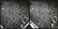
Posted by: kenny Dec 15 2013, 10:40 AM
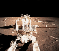
This high res image seems to be from the Mast Camera on the lander. It shows the far side of the crater in front of the Rover, and the landscape to the north.
It was taken later than the one below, as the sun is higher and shadows are a little shorter. Its location is indicated by the box below.
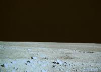
|
This low res image below shows the area north of the Lander before the Rover was deployed. Yellow box inset is the location of the high res.
|
Posted by: Paolo Dec 15 2013, 11:22 AM
A more complete descent video. But I think we still have not seen the complete sequence
http://www.youtube.com/watch?v=lA__4SnHqH8
Posted by: TheAnt Dec 15 2013, 11:37 AM
Congratulations to those who work on the Chinese space program!
And thank you Hungry4info for identifying the landing site.
Now lets see what a lunar rabbit can achieve! 
Posted by: dvandorn Dec 15 2013, 02:13 PM
All right -- ship in port, Captain's gig launched. Way to go!
Congrats to the Chinese Space Agency for grabbing the brass ring on their first try.
-the other Doug
Posted by: kenny Dec 15 2013, 02:29 PM
The rover is due to pass around the east (sunlit) side of the lander in a drive of 10 meters, stopping at 5 different locations for mutual photography.
CNTV says: The 10 meter walk from the lander will take Yutu about two hours due to the bumpy and uneven surface of the Moon. The entire process of
capturing five images will take up to 20 hours to complete. Yutu will take two pictures of the front side of ChangE 3. This is the side where the Chinese
national flag is painted. One of the pictures will be taken from ten meters away, while the other will be clicked from a distance of 18 meters. The moving
path designed for Yutu is a half circle. Pictures will be taken firstly from the back of the lander, and then the side and then the front."
http://english.cntv.cn/program/china24/20131215/103701.shtml
Posted by: craigmcg Dec 15 2013, 02:57 PM
Live coverage now on - but you need a plugin (at least I did):
http://english.cntv.cn/special/lunarmission/index.shtml?0.26375257899053395&0.3195250539574772&0.09102945984341204
Posted by: dvandorn Dec 15 2013, 03:11 PM
A couple of observations about the imaging thus far:
First, the images from Yutu's mast camera seem a little over-saturated. At least, the brightest elements in the images (the rock faces reflecting sunlight right back into the camera) look rather over-saturated to me.
Second, the color rendition from the lander's panoramic camera seems to be biased towards a very brown image, while the rover's color camera is registering more of the expected grayish coloration of the regolith, almost trending towards a slight greenish tinge. Interestingly, these are the same range of color biases that were achieved from the various color film stocks used during Apollo. It took until the later flights for the photo processors to achieve a consistent representation of the grayish lunar regolith; this shows how difficult it can be to get good, representative color from the lunar surface.
I wonder if the mission controllers will be adjusting the color balances and saturation in the released images as time goes on?
Also, looking forward to more of the full video feed from Yutu. That was pretty impressive from the quick flashes we saw during the rover deployment.
-the other Doug
Posted by: Phil Stooke Dec 15 2013, 03:11 PM
If you look back to post 270 (page 18) in this thread (http://www.unmannedspaceflight.com/index.php?showtopic=3105&st=255) I posted a Clementine false colour map of the landing region, showing 'blue' and 'yellow' lava flows.
We landed in the blue unit, but only a few km from the boundary. That boundary shows up as an albedo boundary in my locator sequence as well. So if Yutu drives north they should be able to cross the contact between two flows, getting compositional data for both and using the radar to map the depth of the blue unit as they go.
There is also a mare ridge here, so its structure may be investigated. It could be a very scientifically productive site.
Phil
Posted by: Paolo Dec 15 2013, 03:22 PM
this was posted on facebook a few minutes ago
|
Posted by: Cosmic Penguin Dec 15 2013, 03:38 PM
Note that it appears to be from the rover's NavCam, not the PanCam, so the B/W color should be right.
Posted by: mcaplinger Dec 15 2013, 03:59 PM
Second, the color rendition from the lander's panoramic camera seems to be biased towards a very brown image...
AFAIK, these are all low-res video versions of the original source images, so better quality should be out there somewhere. A little saturation at zero phase would be almost inevitable given the contrasty scene.
As to color, the Apollo astronauts found this to be pretty subjective and phase-dependent, but the consensus was for at least a hint of brown ("mouse gray" and "mouse brown" are often used, whatever that means -- there's a lot of variability among mice too.) White-balancing off the rover's white HGA should work well.
grabbed this from NSF:

|
Posted by: Paolo Dec 15 2013, 04:07 PM
the ground penetrating radar is already working, according to CCTV
Posted by: kenny Dec 15 2013, 04:33 PM
First, the images from Yutu's mast camera seem a little over-saturated. At least, the brightest elements in the images (the rock faces reflecting sunlight right
back into the camera) look rather over-saturated to me.
Second, the color rendition from the lander's panoramic camera seems to be biased towards a very brown image,
The brown-ish low-res pictures are taken by what the CNTV commentator on the deployment calls a set of Monitoring Cameras on the lander. There are at
least 3 one viewing a rear wheel of the rover in its stowed position, another similar view when the Rover got off the deck, and another viewing the
transport mechanism lowering the Rover, viewing between the wheels. This one also photographed the untouched scene looking North, before the lander
deployment got in the way.
http://english.cntv.cn/program/newsupdate/20131215/100518.shtml
The much better grey high-res photo of the boulders on the far side of the crater is taken from a greater height, so must be a mast-mounted Lander PanCam
(Spaceflight101 web site says the Lander has 3 Pancams). I dont think we saw any pics from the Rover until the very recent view of the Lander and descent
ramps from the mast-mounted Rover Pancam, a few posts ago.
Posted by: djellison Dec 15 2013, 04:34 PM
Re:color balance. I think any analysis or processing at this point is pretty much futile. As far as I can tell everything we've seen so far has been a photo taken of a monitor/projector displaying a picture. Nothing has been a native ''image' from the vehicle. So any discussion of color balance etc. needs to include the white balance of the camera that took the picture in a room of unknown lighting of a screen of unknown properties showing a picture of unknown processing level.
Trying to compare the color of what we are seing to what the moon should or ought to be is, in my opinion, at this stage, entirely futile.
Posted by: Phil Stooke Dec 15 2013, 04:42 PM
Color is something that happens in your head.
Anyhoo... check this out and hold on to your seat - fullscreen is mandatory.
Phil
http://news.cntv.cn/2013/12/15/VIDE1387092680807230.shtml
Posted by: dvandorn Dec 15 2013, 04:56 PM
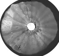
Beautiful! Very familiar interaction pattern between the rocket exhausts and the regolith. Also, looks like at least one of the landing jets kept firing (at least in pulses) for several seconds after touchdown.
And really, really cool how the distant mountainous rim wall slowly sank below the near horizon.
However, as I saw that big crater edge into the scene from lower right, all I could think of was that it seemed like a very long final phase, because the auto-targeting was taking it right into a football-field-sized crater with a large number of big boulders and rocks...
-the other Doug
Posted by: Roby72 Dec 15 2013, 05:14 PM
Phil, is that mountain range at the horizon the Montes Recti ?
Rob
Posted by: Paolo Dec 15 2013, 05:15 PM
I think so
Posted by: Phil Stooke Dec 15 2013, 05:22 PM
Yes, it is.
Phil
Posted by: fredk Dec 15 2013, 05:32 PM
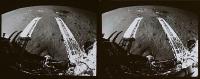
Stereo view of the lander, combining two views posted above. This was tough - I had to alter the aspect ratio (!) of one of the images, and the result is still not good and may induce headaches - this is for expert anaglyphists! (Maybe the two cameras are separated diagonally rather than horizontally?)

|
Cross-eyed:

|
Posted by: Paolo Dec 15 2013, 05:40 PM
the landing video is now more conveniently on Youtube
http://www.youtube.com/watch?v=TaQTSTrbT3w
Posted by: Thorsten Denk Dec 15 2013, 05:47 PM
Why must be lunar landing videos always upside down??
Some expert here able to turn it round?...
Posted by: craigmcg Dec 15 2013, 05:48 PM
Amazing how stable it was during the hovering portion.
Posted by: Thorsten Denk Dec 15 2013, 05:53 PM
I posted a Clementine false colour map of the landing region, showing 'blue' and 'yellow' lava flows.
[...]
Phil
Can you explain shortly what's known until now about the two lava types?
More / less ... Iron / Titanium / Ilmenite / whatever?
Btw: It seems that YOU were able to foresee landing site selection criteria. Great!
Thorsten
Posted by: djellison Dec 15 2013, 05:55 PM
http://m.wikihow.com/Turn-Your-Computer-Screen-Upside-Down
Posted by: Phil Stooke Dec 15 2013, 06:02 PM
Blue flows in the image linked to are high Titanium.
Phil
Posted by: kenny Dec 15 2013, 06:09 PM
Now THAT is jaw-dropping... the swear box may have to resurrected !
Although the main engine was supposed to cut out before the final drop, it looks like the smaller engines kept firing and blowing dust after touch down.
Best thing since the Apollo 17 descent movie of December 1972....
Note the giant boulder which is not far to the SW of the landing site. We can hope to see it later from the ground.
Posted by: ollopa Dec 15 2013, 06:17 PM
Phil: Emily RT'd yesterday:
@BrownGeoSci prof Carle Pieters says Chang'e 3 landed in "some of the unsampled young hi-Ti basalts!"
I never found the original post, but can you (or others) point to a definitive discussion of the high/low Ti issue? Are "unsampled young hi-Ti basalts" a sufficient priority to the lunar community to justify a campaign of rovers and SRM's in this region?
Phil
Posted by: OWW Dec 15 2013, 06:59 PM
http://www.youtube.com/watch?v=TaQTSTrbT3w
Convenient yes, but also much more compressed than the one on the Chinese site. If you want a better copy, you will get much better quality by capturing the original (with Afterburner for example).
Posted by: Thorsten Denk Dec 15 2013, 07:31 PM
This landing video, is it real time?
I tried to find out with the free fall time from 4 meters high with the engines off (2.2 sec),
but it's not clear when (or if) the engines stopped.
Posted by: Greenish Dec 16 2013, 01:38 AM
Regarding Ti, lava, etc. this is very informative. From Jonathan McDowell on Twitter:
@planet4589: Good article by Paul Spudis on Imbrium selenology http://blogs.airspacemag.com/moon/2013/12/a-new-site-to-explore-on-the-moon/
Posted by: kenny Dec 16 2013, 09:09 AM
I know we are not convinced by the inconsistent colours we are seeing from the different cameras, but brightness is a different matter.
Is anyone else intrigued by the unusual paleness, almost white, of the rocks around the crater rim behind Yutu?
Posted by: ollopa Dec 16 2013, 11:15 AM
"The optical properties on the Moon are most peculiar"
Neil Armstrong talking to Patrick Moore: a masterclass in lunar surface colour perception.
http://www.bbc.co.uk/programmes/p007x88t
I still can't believe they're both gone. Patrick died a year ago last week.
Posted by: dilo Dec 16 2013, 02:23 PM
I still can't believe they're both gone.
At the end of the interview, Armstrong says he's "quite sure" he will see lunar stations built in his lifetime...

Posted by: Phil Stooke Dec 16 2013, 03:29 PM
http://www.youtube.com/embed/QzZkF1MAsb8
The landing video rotated 180 degrees so you don't have to hang upside down off the bookcase to view it.
Phil
Posted by: vikingmars Dec 16 2013, 04:03 PM
The landing video rotated 180 degrees so you don't have to hang upside down off the bookcase to view it. Phil
How nice !!! Thanks a lot Phil !!!
Posted by: Phil Stooke Dec 16 2013, 05:29 PM
You're welcome, Olivier.
The other equipment is being started up now, the radar, the UV telescope etc.
Phil
Posted by: kenny Dec 16 2013, 05:55 PM
Paul Spudis of LPI likes the Mare Imbrium lava flows....
"...this site is actually more interesting geologically than the spacecrafts original destination."
http://blogs.airspacemag.com/moon/
Posted by: gndonald Dec 16 2013, 06:02 PM
Congratulations to China for their achievement.
Posted by: elakdawalla Dec 16 2013, 06:32 PM
Folks, I've just done some long-overdue forum housekeeping: http://www.unmannedspaceflight.com/index.php?showforum=74
I split the one very long Chang'e thread into four:
- http://www.unmannedspaceflight.com/index.php?showtopic=3105
- http://www.unmannedspaceflight.com/index.php?showtopic=7759
- The thread you are in is the one for landing and first lunar day of operations; we'll start a new thread for the second lunar day of operations when that happens.
- http://www.unmannedspaceflight.com/index.php?showtopic=7760
- And there is, as promised, a http://www.unmannedspaceflight.com/index.php?showtopic=7756. The usual rules for that one apply -- no chit-chat in there, keep it clean for just route map updates.
When the Chang'e thread started, we only got very limited information out of China. It's wonderful we're getting so much information now to need this proliferation of forum topics
Posted by: Phil Stooke Dec 16 2013, 09:26 PM
The latest update of my Moon map showing all nearside artifact locations. This might need updating quite often in the next few years... starting with a LADEE impact in the spring.
Phil
|
Posted by: elakdawalla Dec 16 2013, 09:52 PM
I didn't realize until I was sorting through my screen grabs from yesterday that there were two different photos of Yutu returned from the lunar surface. There's a significant amount of shadow motion between the two, and a small shift in the vertical position of the rover mast.
|
|
Posted by: nprev Dec 16 2013, 10:01 PM
Great map. Phil!
The only critique I'd offer is that you might consider choosing a color other than black for the 'other nations' category; it's a bit difficult to pick out from the lunar map background. Green or yellow?
Posted by: ustrax Dec 16 2013, 11:19 PM
Here it is:
http://i.picasion.com/pic76/d84f6711074d509e53e1fb1b52915a49.gif
Posted by: Cosmic Penguin Dec 17 2013, 08:00 AM
Anyone here willing to find possible points of interests for the rover to head for within 10 km of the landing site using the LRO maps?
Posted by: Explorer1 Dec 17 2013, 09:45 AM
The weird crater at the bottom center of the second image on this page? Around four km to the south of the landing site, I guesstimate.
It looks bizarre, very different from its neighbors of the same size. Unusually fresh perhaps?
But going north for the titanium geology is probably a better option....
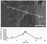
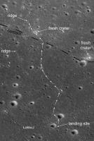
Posted by: Phil Stooke Dec 17 2013, 02:11 PM
I never could resist a challenge like that.
Here is a path that starts out by looking at several craters along the way (also 'crater-hopping' like this is a good way to keep track of where you are). Then it crosses the geological contact between two basalt flows, examines a very fresh impact crater and finally gets to an interesting mare ridge. The ridge would offer chances to use the GPR to examine its structure in several places.
Phil
PS welcome back Ustrax!
PS2 - there was talk of us being in a hiatus, Dec. 16-23, during the hottest part of the lunar day, so maybe a few days without pics.
|
Posted by: vikingmars Dec 17 2013, 02:32 PM
Wow ! That's a +/- 15 km trek ! This is a great idea Phil : I hope they could do it.
Anyway, CONGRATULATIONS to our Chinese "Moonrakers" !!! 
Posted by: 4th rock from the sun Dec 17 2013, 03:05 PM
I tried to stack those grabs with higher resolution versions (from www.news.cn) and indeed the higher resolution versions are photographs of a screen.
They cover less area than the screen grabs and have geometrical distortion (skew, field curvature and vignetting).
So I'd say that the TV grabs are being generated from the digital data. The geometry and levels are consistent.
Here's the stack of both TV frames. I corrected gamma and color balance so that the surface is neutral brown and pushed color saturation a bit to account for overexposure.
The main thing is that the ground color does tend towards grey, as expected (even more if you reduce saturation). The other hues are within what's expected for raw uncalibrated images.
|
Posted by: Phil Stooke Dec 17 2013, 04:24 PM
"Wow ! That's a +/- 15 km trek ! "
Yes, maybe a bit long. To keep it to 10 km Yutu could aim for the other fresh crater and meet the contact at the same place. But no ridge...
Phil
Posted by: dilo Dec 18 2013, 05:51 AM
Correct me if I'm wrong, no updates nor new pictures were released in last 2 days...
Posted by: djellison Dec 18 2013, 06:03 AM
This thread already includes an explanation
From Phil
http://www.unmannedspaceflight.com/index.php?s=&showtopic=7758&view=findpost&p=205662
" there was talk of us being in a hiatus, Dec. 16-23, during the hottest part of the lunar day, so maybe a few days without pics. "
Posted by: Explorer1 Dec 18 2013, 08:19 AM
They're probably erring on the side of caution, after what happened to Chandrayaan and its heating issues.
Posted by: bobik Dec 18 2013, 08:23 AM
There is also a Lunar Dust Integrated Load Measuring Instrument (月尘测量仪的综合载荷) on board of the Chang'e 3 lander. It seems to be viewed as engineering rather than scientific experiment.
http://210.14.113.38:9080/asop/login.asop?titleId=375
Posted by: vikingmars Dec 18 2013, 10:52 AM
[quote name='djellison' date='Dec 18 2013, 07:03 AM' post='205692']
Agree ...and also, because knowing very well our Chinese friends,
(i) they do not have the same kind of "live" outreach policy as we have in the USA and in Europe and
(ii) maybe they are waiting for a big Press conference showing science results to reveal more images to the public, including a full 360° imaging pan.
They have already shown us their willingness for an open-minded outreach policy in showing us live the descent of Change-E on the Lunar surface. I think they are now also taking more into account our cultural need for "instant science".
So, let's be patient and wait a little bit more...
Posted by: kenny Dec 19 2013, 12:20 PM
LRO will make repeated observations of the Chang'e 3 landing site to overview surface changes from the descent engine blast and rover movements.
http://www.space.com/23997-nasa-spacecraft-china-moon-lander.html
Posted by: kenny Dec 19 2013, 03:36 PM
Despite the lack of new images, all was apparently working well yesterday, according to Xinhua...
SIX out of the eight pieces of scientific equipment deployed to the moon with the Chang'e-3 lunar mission have been activated by scientists and are functioning
properly, according to scientists working on the mission.
Speaking at a news conference on Tuesday, scientists said that the equipment aboard the Yutu lunar rover and the Chang'e-3 lander had so far been functioning
as hoped, despite the unexpectedly rigorous conditions of the lunar environment.
"Except for the alpha particle X-ray spectrometer and the visible and near-infrared imaging spectrometer, the instruments have all been activated and are
undergoing tests and adjustments," said Su Yan, deputy designer of the Chang'e-3 ground applications system.
Zhang He, deputy designer of the probe, said though the temperature disparity is greater than scientists had anticipated, all the equipment on the moon is
in "perfect" condition, and optical and ultraviolet-imaging experiments are under way.
http://news.xinhuanet.com/english/china/2013-12/18/c_132977079.htm
Posted by: dilo Dec 20 2013, 09:54 AM
At this point, two considerations arise to me.
First one, if such cautionary stop around local noon will be adopted also in the next two lunar days, effective time available for roving/exploring will be very limited... perhaps no more than 25% of total mission time, less than 22 terrestrial days (considering also the obvious stop during local night).
Second consideration is about next mission. Based on article, "Given the success of Chang'e-3, the Chang'e-4, a backup probe, will be upgraded and serve as a prototype for the technologies being used in the Chang'e-5"; so, if I correctly understand, the planned launch of sister probe Chang'e-4 in 2014 will never come!
On the bright side, it seems that next year we will see two total sun eclipses from moon, at least from the lander! http://www.universetoday.com/
Posted by: Phil Stooke Dec 20 2013, 01:41 PM
I think it's more likely the launch of Chang'E 4 will come - I expect it in 2015, and I expect it to test sampling technology, improved rover autonomous navigation, maybe better thermal control etc.
Phil
Posted by: Paolo Dec 20 2013, 02:06 PM
wow!
http://v.qq.com/cover/c/ctklokz7zk0a9y3.html?vid=f0013ghuxv8&start=31
Yutu is on the move...
Posted by: SpaceListener Dec 20 2013, 03:20 PM
Initially, the spaceship Change'e-4 was planned as a backup of ones' e-3. However, the possibility that the Change'e-4 will perform will depend upon to how successfull is the mission of Change'e-3 on Moon. Thus, the Chinese space agency has showed to be very patient and meticulous with their programs, he only repeats when the mission has not attained according to their plans.
It would be interesting that Chang'e-4 land on another interesting site with much improved the landing precision such as why the Chang'e-3 has not landed close to the Laplace A Crater and ridges as initially. At this point, I don't know if present landing site, close to Laplace FA was as planned or not. 
Posted by: 4th rock from the sun Dec 20 2013, 03:35 PM
The video link posted above shows a panorama. Strange release: a video pan of a panorama!
From the footage it looks like a full 360º and with nice quality too.
Posted by: Phil Stooke Dec 20 2013, 07:31 PM
Very low-res view of our site:
|
Phil
Posted by: craigmcg Dec 20 2013, 07:56 PM
I'll say...
Posted by: Phil Stooke Dec 20 2013, 08:04 PM
And some screenshots... better resolution this time!
Phil
|
|
Posted by: Thorsten Denk Dec 20 2013, 10:47 PM
Early wakeup from the Siesta!
http://news.xinhuanet.com/english/china/2013-12/20/c_125893854.htm
At about 8:00 p.m. Beijing Time, the six-wheeled rover started moving again after shutting down its subsystems on Dec. 16.
[...]
"The break had been planned to last until Dec. 23, but the scientists decided to restart Yutu now for more research time, based on the recent observations and telemetry parameters," said Pei Zhaoyu, spokesman for the lunar program.
Thorsten
Posted by: Phil Stooke Dec 21 2013, 03:41 AM
Not the greatest material to work with but here's a quick attempt to pull a pan together:
|
|
and a circular version:
|
Phil
PS that very low res pan above was made from the circular panorama that flashes up on the screen in the video. I uncircularized it but as the original was bad the pan was too.
Posted by: wildespace Dec 21 2013, 08:35 AM
Great job! Can anyone please upload this panorama to Photosynth? If not, I'll try to do it myself.
Posted by: kenny Dec 21 2013, 09:28 AM
Fuzzy but still great, Phil, compared with the continuously moving version we saw on TV. There's the big triangular boulder we saw on the descent movie to
the south of the lander, and the rocky far wall of the big crater just west of the landing site.
I'm looking forward to seeing some high-res, but they don't seem to have a scientific web site for the release of photos and it's mostly done through the
news agency route, which means that the criteria for "newsworthiness" is somewhat random.
Posted by: 4th rock from the sun Dec 21 2013, 09:49 PM
Doesn't seem to improve upon the overhead views, but that's expected working from streaming video.
Anyway, here's a link with some new video stills from the pan:
http://www.ecns.cn/visual/hd/2013/12-21/29901.shtml
They are all zooms and photos of the same big display.
BUT a search using chinese characters turned good stuff!
Some decent images from the deployment sequence. Not raw but close, including stereo pairs and landing sequence final frames.


More here: http://chn.chinamil.com.cn/jdtp/2013-12/15/content_5691236.htm
It looks like original data:
Original here: http://news.sohu.com/20131221/n392176417.shtml
Posted by: elakdawalla Dec 21 2013, 10:52 PM
Hmm. As far as I can tell, the photos at http://chn.chinamil.com.cn/jdtp/2013-12/15...ent_5691236.htm are still photographs of the displays at the Beijing control center, so we're still not anywhere close to raw images, but I agree that they are better-quality photographs of the displays than I've seen previously.
Posted by: 4th rock from the sun Dec 21 2013, 11:05 PM
Yes.
I was talking about the overhead map. That was assembled from the original data. I checked with the descent frames and indeed for the map they were geometrically corrected.
So now we can derive a scale for the descent frames :-)
Nevertheless, it looks that the oficial site is that one - China Military.
Here's a pan I made from the photos on the link:
http://imageshack.us/photo/my-images/850/fkcy.jpg/
Posted by: Phil Stooke Dec 21 2013, 11:34 PM
Very nice! Let's hope we get some more of these pics.
Phil
Posted by: Liss Dec 22 2013, 08:15 AM
Phil
Today's two from http://china.cnr.cn/gdgg/201312/t20131222_514462502_1.shtml :
Lander from point D or E:

Going south (point E):

Posted by: dilo Dec 22 2013, 09:06 AM
Fantastic images, finally! 
Some crossed-eyes stereograms based on China-mail images (original screen captures were for parallel eyes):
|
|
|
Posted by: Explorer1 Dec 22 2013, 09:31 AM
What a change from ten years of looking at Mars images, huh? A strangely close horizon, long days, and of course no haze from air in billions of years...
Still no sign of Earth in the sky though; perhaps Yutu would have to park on a slope tilted to the north to see high enough?
Posted by: pospa Dec 22 2013, 01:48 PM
I assume not necessarily. Yutu's camera mast has deployment actuator whitch perhaps can be use to fold the mast back. If not possible then the camera "head" should have its own elevation actuator to aim pancams and navcams up and down.
I guess they will take a picture of the mother Earth very soon. ... with China in the middle if constellation allows that, whith I'm not sure about
Posted by: kenny Dec 22 2013, 02:01 PM
According to CNTV, the mutual photography sessions are over, five sessions in all, and the science work begins. Hopefully we will still see the occasional
distant views of the pair as they move further apart. I guess the large boulder SW and the large crater to the West will make nice targets.
"This was the fifth time the rover and the lander took photos of each since they arrived eight days ago. Scientists in Beijing have been processing them
and say scientific tasks can now begin.
"Ten pictures have been taken at five spots so far, and all of them are better than we expected. The rover has moved in a semi-circle around the lander.
Afterwards, they will begin to conduct scientific explorations of the geography and geomorphology of the landing spot and nearby areas, and materials
like minerals and elements there. We will also explore areas 30 meters and 100 meters beneath the lunar soil. The exploration will continue longer than
we planned, because all the instruments and equipments are working very well," said Wu Weiren, chief designer of China Lunar Probe Program."
http://english.cntv.cn/program/china24/20131222/103912.shtml
Posted by: 4th rock from the sun Dec 22 2013, 04:23 PM
Two photos that make a nice stereo pair of the lander here:
http://chn.chinamil.com.cn/jwjj/2013-12/22/content_5701132.htm
For convenience, I've assembled them:
|
Also interesting is a new pan from video grabs here:
http://d1jqu7g1y74ds1.cloudfront.net/wp-content/uploads/2013/12/Change-3-1st-Pano_Ken-Kremer.jpg
Posted by: Ron Hobbs Dec 22 2013, 04:49 PM
I stumbled on the "Going south" image above on a Russian forum (I was searching for information on the Nauka module to ISS).
http://www.astronews.ru/cgi-bin/mng.cgi?page=astrofoto&id=949
The caption, translated by google reads:
"Chinese lunar rover Yuytu works in normal and stable mode after restarting on Friday. According to information rover again began to move off after the auxiliary parts of the system on December 16.
During December 21 "Jade Hare" drove 21 meters."
"Jade Hare," I like it. It seems that the Chinese have a global following of their mission whether they want it or not.
It looks to my uneducated eye that C3 might have landed up on one of the wrinkle ridges. Looking south I see a lower plain. Anyone know if that is true?
Ron
Posted by: SFJCody Dec 22 2013, 05:48 PM
It's all very exciting this isn't it? A new lunar site, the first in decades!
The flag decal on the lander looks extraordinarily clear! Little touch of imagery enhancement, maybe? Not that I'd blame them, they have every right to be proud.
Posted by: tolis Dec 22 2013, 06:19 PM
During December 21 "Jade Hare" drove 21 meters."
The name is highly inappropriate. It's a *rover*, not a hopper..
Posted by: dilo Dec 22 2013, 06:22 PM
http://d1jqu7g1y74ds1.cloudfront.net/wp-content/uploads/2013/12/Change-3-1st-Pano_Ken-Kremer.jpg
I think is better to report also the source
:http://www.universetoday.com/107388/chinas-1st-lunar-lander-snaps-1st-landing-site-panorama/
Posted by: dvandorn Dec 22 2013, 07:27 PM
I find it interesting that earlier American and Soviet unmanned landers made, almost immediately after landing, images of the interaction between the landing gear pads and the surface. Heck, the famous first shot from Surveyor 1 is of the landing gear pad and shows how it pushed back the lunar soil. (Yes, there were some Soviet landers that had no landing gear, much less footpads, and I know that the final Soviet sample return mission landed in the lunar night and didn't return a lot of scenic photos. But for those with landing gear pads that landed in sunlight, the first pics seemed always to be of the gear-soil interaction.)
In addition, I believe that pretty much all of the American Mars landers that used gear and footpads did the same thing. Remember the first image from the Viking 1 lander? A pic of the footpad sitting on the ground.
Chang'e 3 didn't take such images from the lander, at least that I've seen. But the latest images of the lander from Yutu seem to show very definite piles of freshly disturbed regolith sitting radially outwards from each pad. Not radially distributed around the circular pad -- radially from the lander itself. Out along lines drawn between the center of the vehicle through each footpad.
The only dynamic I can think of that would preferentially throw soil outwards from each pad would be one where the gear actually flexed outward, away from the octagonal lander body, at touchdown and then recoiled back to their normal deployed position. As the gear and struts look rather similar to the Apollo LM arrangement, this doesn't sound like something they would be designed to do.
Just an observation...
-the other Doug
Posted by: Phil Stooke Dec 22 2013, 09:09 PM
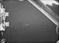
There was this descent camera image taken after landing, showing a footpad at far right. The camera on top of the lander can't see the footpads.
Phil
|
Posted by: dvandorn Dec 22 2013, 09:26 PM
Phil
Oh, yes -- a sliver of the footpad is visible, and the ground around it is in deep shadow.
I guess what I was noting was a difference in philosophy between the American (and to a somewhat lesser extent Soviet) engineers and the Chinese engineers. On American unmanned landers, the cameras were specifically positioned to provide initial images of a footpad on a lighted surface. The Chinese did not specifically position their cameras to be able to do this.
I'd bet this is a sign of confidence in the current knowledge of surface conditions. On Surveyor, the flight engineers wanted an initial confirmation that their craft was planted firmly on the surface. The surface conditions were far less well known at that time, and an image showing the footpad firmly on top of (not hanging above and not sunk deeply into) the surface was an important confirmation of the potential for successfully completing the mission.
The Chinese, on the other hand, are starting out with a far better operating knowledge of the surface conditions, and with more sophisticated IMU-based navigation than was available to early Luna and Surveyor craft. Therefore, there is less of an urgency to position a camera just so it can give you a confirmation that a footpad is firmly resting on the surface. Other imaging priorities come in to play, and hence you don't get the classic footpad shot.
Again, just an observation.
-the other Doug
Posted by: Marvin Dec 23 2013, 12:59 AM
Just an observation...
-the other Doug
When I first saw the lander, only one pad was visible and I thought it may have bounced or skidded. But now that we can see more of the pads, I think you're right in describing what happened.
It was also intentional. According to spaceflightnow, "Chinese officials said they designed the craft's landing sets with impact suppressors similar to shock absorbers."
http://spaceflightnow.com/china/change3/131214landing/#.UreIr7RjLnQ
Posted by: bobik Dec 23 2013, 09:37 AM
http://news.qq.com/a/20131218/015600.htm (in Chinese)
Posted by: kenny Dec 23 2013, 10:27 AM
away from the octagonal lander body, at touchdown and then recoiled back to their normal deployed position. As the gear and struts look rather
similar to the Apollo LM arrangement, this doesn't sound like something they would be designed to do.
The Apollo pads were on a ball-and-socket joint on the end of the legs, so they could swivel and conform to any orientation of surface upon landing.
I wouldn't be surprised if the Chinese adopted this aspect of the design also, as they appear to have copied the rest of the Apollo strut/ leg arrangement.
So the quick flipping of those rotating pads upon impact would be the simplest explanation for throwing the dirt.
I noticed those clumps too, and was thinking it's a pity they didn't photograph them more closely from the Rover. A good chance to make an observation
about soil dynamics and granularity. See also how deep the tracks gouged into soft soil where Yutu did its turn in front of the lander.
Posted by: djellison Dec 23 2013, 03:56 PM
They may very well have done so - I'd think we've seen only a tiny fraction of the total number of images taken.
Posted by: pospa Dec 23 2013, 04:37 PM
Yutu's robotic arm successfully deployed (in Chinese) http://www.chinanews.com/gn/2013/12-23/5653502.shtml
Night hibernation will start around Dec 26th and lasts about two weeks.
Posted by: SFJCody Dec 23 2013, 06:01 PM
Haven't seen this pic posted previously.
http://roll.sohu.com/20131223/n392264881.shtml
There also seems to be some new footage in this youtube video:
https://www.youtube.com/watch?v=R9qhPWbwwhc
Posted by: walfy Dec 23 2013, 08:54 PM
I'm surprised they haven't immediately pounced on the rocks, soil just in front of them on the crater edge to at least get some observations with the instruments. One never knows when our robots decide to shut down for good! Perhaps it bespeaks of great confidence with the health of the machine.
Posted by: Explorer1 Dec 23 2013, 09:30 PM
Amazing how far the mast can 'lean' forward; though it doesn't tell us how far it can tilt up. An Earth image from either lander or rover would be astounding....
Posted by: Thorsten Denk Dec 23 2013, 09:33 PM
The most urgent usually is taking a picture of the flag...
http://www.calsky.com/ gives the following table for physical ephemeris:
Date: 2013, Dec 26:
Time Sub-Solar
UTC ..... Lat Lon
hh:mm .... o .... o
13:00 +1.32 251.1
13:15 +1.32 251.0
13:30 +1.32 250.9
13:45 +1.32 250.8
14:00 +1.32 250.6
14:15 +1.32 250.5
14:30 +1.32 250.4
14:45 +1.32 250.2
15:00 +1.32 250.1
15:15 +1.33 250.0
15:30 +1.33 249.9
15:45 +1.33 249.7
16:00 +1.33 249.6
Hence sunset should be centered around 14:15 UTC on Dez 26
(not taking into account the solar latitude ≠ 0).
And the subsequent sunrise will be around 09:00 UTC on Jan. 10.
Hope I'm not wrong.
Thorsten
Posted by: ugordan Dec 23 2013, 10:12 PM
... or underwhelming, depending on the angular resolution of the cameras...
Posted by: Hungry4info Dec 23 2013, 10:15 PM
Since the mast was originally stowed in the body of the rover (and can return there for lunar night?), I assume it can look "up" high enough to see Earth.
Posted by: Reed Dec 23 2013, 11:04 PM
Given that the HGA is fixed to the same mast, it better be able to aim at the earth
This suggests there should be earth photo ops every com pass, but perhaps they are still relaying through the lander? (edit: or the results are underwhelming as ugordan suggests)
Posted by: dvandorn Dec 24 2013, 01:51 AM
Remember that the eye needs something to put an image into scale to make it appear impressive. Consider that while there are many images of Earth from cislunar space and lunar orbit, it's the ones framed against the lunar horizon that get put on postage stamps...
As Chang'e's landing site is at 45 degrees north and about 20 degrees west, I'd think that the Earth is no lower than about 45 degrees up in the sky at any given time. An image captured of it using Yutu's camera would likely show only the Earth, and nothing of the horizon below. In that way, it would be indistinguishable from a picture taken of Earth from lunar orbit which also included no portion of lunar surface in the frame. Just another pic of Earth from a lunar distance, nothing really special.
Now, if Yutu pulls up against a nice-sized piece of surface relief, spotting the Earth as it sits above a peak, or a rock, could be a dramatic shot. Not seeing anything in the near vicinity that would fill that bill (except maybe for heading down into a deep crater), I dunno when we might see that kind of photo op.
-the other Doug
Posted by: mcaplinger Dec 24 2013, 02:20 AM
I could fix that problem in Photoshop in about 5 seconds
I tried to figure out how many pixels across an Earth image would be, but couldn't find the focal length or the FOV of these cameras. That could be guessed from the sizes and ranges of the hardware, but I'm too lazy.
Posted by: Explorer1 Dec 24 2013, 02:34 AM
But it doesn't have to be a single shot like Cernan's 1972 famous http://www.hq.nasa.gov/office/pao/History/alsj/a17/AS17-134-20387.jpg at all!
Yutu can just take a series of images from horizon up or Earth down and then have them stitched together vertically, like the folks on this forum do all the time! The main issue would be to avoid pointing the camera too close to the Sun...
It's not like there's a rush anyway; it can always be done next sol/month/lunar day (any standard vocabulary for us to use yet?).
Posted by: climber Dec 24 2013, 07:37 AM
I believe the most dramatic iconic picture will be to have the Earth with either Yutu or the Lander in the same field of view...and I don't believe all pictures been taken so far have been released. If the geometry has been already right, we'll see such a picture in due time. If we don't, we know Mike can do it for us
Posted by: kenny Dec 24 2013, 09:45 AM
You can calculate the Earth altitude in the sky from the landing site co-ordinates, as I did earlier. Since the actual landing site was a little closer to the
sub-Earth point than planned, it may be a little higher than this. Someone may need to check my rusty maths.
<Cernan did not take a proper "selfie". That picture was taken by Jack Schmitt.>
Admin: Subsequent posts on this were moved to the http://www.unmannedspaceflight.com/index.php?showtopic=6771&view=findpost&p=205876. As a member pointed out the discussion is "ridiculously off topic".
Posted by: Paolo Dec 24 2013, 09:58 AM
first data from the IR spectrometer
http://www.sitp.ac.cn/xwzx/kydt/201312/t20131224_4003884.html
Posted by: bobik Dec 24 2013, 04:49 PM
http://www.sitp.ac.cn/xwzx/kydt/201312/t20131224_4003884.html
and in the News: http://v.qq.com/page/y/0/g/y0013eglj5g.html
Posted by: SFJCody Dec 24 2013, 07:02 PM
This image has been seen before, but not at this resolution without the CCTV ident.
http://news.cnblogs.com/n/196533/
Posted by: Astro0 Dec 25 2013, 08:38 AM
New UMSF member Gofar contributed (via PM to the admin/mod team) this translation from a Chinese news report.
Thanks Gofar for your efforts. (Parts of this were reported in the http://www.unmannedspaceflight.com/index.php?showtopic=7756&view=findpost&p=205886 thread).
-------
Xinhua news agency
24th December
Where will Jade Rabbit go to next?
The Chang'e 3 lander and moon lunar rover are still in intense work. Beijing spaceflight control center has completed the hibernation setup, and beginning from December 25th, they will enter a dormant state.
Reporters at the Beijing Aerospace Control Center were informed that on the 23rd to 24th December, the landers topography (terrain)camera completed the panorama within 24 hours imaging five pans at different pitch angles. The original plan was to complete only one panorama in a day. Deputy Director, Wu Fenglei of the Beijing Aerospace Control Center said the lander will be scheduled around 7:00 in the morning on the 25th into the lunar night sleep mode and the lunar rover will start its lunar night sleep around 1:00 on the 26th December.
Where to go?
It is reported that scientists have screened several objectives of interest including: a large stone pyramid southwest about 42 meters from the lander, which scientists have never seen before; an area of high ground in the west direction, overlooking the surrounding environment; and a crater more than 10 meters at the north.
It is reported that scientists have screened several targets of interest. Chang'e 3 lunar probe Deputy Chief Jia Yang said, We will actively meet the needs (demands) of the scientists while considering the engineering technology to ensure the smooth implementation of the rovers safety and subsequent task of target selection. We have to consider the ability of the lunar rover and also consider that 26thDecember will usher in the first lunar night after landing on the Moon and find a suitable terrain for the rovers hibernation. So where (to hibernate), is a combination of opinions from scientists and engineers.
Are you ready?
After the 15th December landing, the rover separated from the Chang'e 3 lander and inspected it from the north, then driving south along the sunny eastside. The inspections were completed in five locations with the lander and rover imaging each other. Ground control personnel have been planning and controlling use of the panoramic camera on the rover over the past few days the moon, taking shots around the landing area and have generated three-dimensional topographic maps.
Currently the lunar rover is in the testing phase. In the process of moving to several points, the moon radar was also tested to ensure that its working. "We want to confirm that each of the rover functions are normal." Jia Yang said.
Rover Mission Planning Manager (Inspection task planning technical director) Li Qunzhi said "So far, the real situation of the lunar surface with our pre-drill on the ground too much like, before suggesting that we carried out in the field, field experiments have played a significant role, so we do not have too much pressure".
How to go?
In determining the direction of a big goal, that is, after the strategic plan, the rover's remote operators need to do more detail planning.
We want (the drives) to be divided into intervals of 7-10 meters, planning out the sequence according to the information we get from the panoramic camera," Jia Yang said. The remote operators do path tactical planning, addressing how to reach a point 7-10 meters away, with the main consideration being the terrain conditions.
The goal is to rely on the determination of the panoramic camera, which is characterized by a smaller field of view, but the high resolution can obtain high accuracy of the topography within 30 meters. The path of 7-10 meter planning relies on the navigation camera, planning travel routes. After the path planning, remote operators run a simulation on a computer with a digital lunar rover, to test the results and confirm the plan is correct.
Posted by: Explorer1 Dec 25 2013, 08:48 AM
So basically identical to the MER and Curiosity sol planning method? Fascinating in its similarity, but if it ain't broke...
Pass on our thanks to Gofar!
Posted by: Gofar Dec 25 2013, 09:23 AM
Lastest news to share with the JRabbit fans here ,
by Gofar
From Xinhua Agency ,1013-12-25,Jade Rabbit is going to hibernate in the first coming moon night.
So Merry Christmas to everybody here who cares about it and wish the Rabbit can surive the cold nights on the moon.
Tomorrow, the moon three lander and moon lunar rover will usher in the first "moon moon after". Because there will be no sun to provide energy, at the same time to resist the moonlit night of minus 180 degrees Celsius, the lander and rover will successively in the morning and tomorrow morning into the moonlit night sleep, time will last about half a month.
月球车除了完成科学探测的任务外,还要经受月午和月夜两种极端恶劣环境的考验。月午是月面受太阳光照射比较强烈的时间,届时月面温度高达100多摄氏度,为保护科学仪器,月球车要午休。而当月夜到来时,由于没有任何太阳光照射,月面温度将降到零下180多摄氏度,玉兔号将面临低温的考验。
In addition to the completion of Scientific Exploration Rover Mission, but also endure the noon and night on two kinds of extreme harsh environment test. Afternoon is the lunar month light from the sun is strong time, when the surface temperature up to 100 degrees Celsius, for the protection of scientific instruments, the lunar rover must "break". And when the night comes, because there is no sunlight, the lunar surface temperature will drop to minus 180 degrees Celsius, "rabbit" will face the low temperature test.
据北京航天飞行控制中心相关负责人介绍,按预定计划,着陆器将于今天早上7点左右进入月夜休眠;月球车紧随其后,将于后天凌晨1点左右开始月夜休眠。它们这一觉要睡半个月左右,大约于明年1月12日醒来,继续工作。
According to the Beijing Aerospace Control Center related to the person in charge, according to the schedule, the lander will sleep in the morning and 7 pm to enter the moon; lunar rover followed, the day after 1 a.m. start night sleep. They had to sleep for about half a month, about in January 12th next year to "wake up", continue to work.
据了解,为提高科学探测和月面测试效率,地面科技人员近两日逐渐加大了着陆器和月球车的工作强度。月球车已经完成了红外光谱仪加电、原地转弯等一系列月面测试工作。在开始月夜休眠之前,它们需要完成休眠前的全部状态设置。
It is understood, in order to improve the scientific exploration and lunar test efficiency, the ground nearly two technical personnel, gradually increase the work intensity lander and rover. The rover has completed the infrared spectrometer with electricity, swerve and a series of lunar test. Before the start of the night sleep, they need to complete the state before dormancy settings.
Posted by: Explorer1 Dec 26 2013, 01:58 AM
I wonder how useful it would be to position the rover on an east-facing slope each 'evening', so it can get sunlight on its panels a few hours earlier the next month. Crater edges are easy enough to find, and we know how important tilt was for surviving Martian winters. Yutu has to face such conditions every 14, rather than 300 days! Might as well get whatever benefits they can from the environment.
Posted by: Phil Stooke Dec 26 2013, 03:39 AM
As I see it, one panel is closed over the warm camera compartment, so it's not available. The other can be tilted anyway, so all the rover has to do is turn so that panel points east and tilt it down to catch the morning sun.
MER's issue was not being able to tilt its panels without tilting the whole rover.
Phil
Posted by: Paolo Dec 26 2013, 10:26 AM
a paper in Chinese on the thermal design of the APXS instrument on Yutu. also gives some detail of the RHUs
http://www.cjss.ac.cn/EN/abstract/abstract1994.shtml
Meanwhile, Yutu and the CE3 lander both went to sleep
http://news.xinhuanet.com/english/sci/2013-12/26/c_132998160.htm
Posted by: iwantastarship Dec 26 2013, 03:31 PM
There's a bit about where to position the rover for it's nap, I hope I translated this right.
http://news.xinhuanet.com/mil/2013-12/25/c_118705332.htm?prolongation=1
There are 3 requirements for the rover's resting spot, firstly the head of the rover must face south east, secondly, the head of the rover should be higher than the end, theses two requirements are easier to meet. Thirdly and the most difficult requirement to fulfill, the incline between the rover's left and right should be between 1-2 degrees.
The article then talks about not finding a suitable spot and getting the rover to 'dig a hole(ditch?trench?)'.
We had the wheels spin to meet the requirements(of the resting spot). Currently Yutu is 40m south of the lander, before the adjustments, it was overly inclined towards the left, we had the wheels spinning in different directions in order for the rover to slant approximately 3 degrees to the right.
Posted by: Phil Stooke Dec 26 2013, 04:15 PM
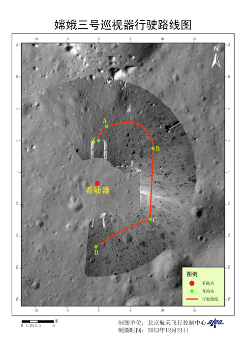
Interesting! 40 m south... so it has moved south again in the last few days - probably close to the bottom of my map and closer to the big rock it will look at after it wakes up.
I hope we will see pictures with a lower sun angle soon.
Phil
Posted by: Phil Stooke Dec 26 2013, 05:52 PM
we were discussing images of Earth from Chang'E 3 earlier. This might be one:

|
(top left ) in a screenshot from here:
http://tv.sohu.com/20131226/n392438358.shtml
Phil
Posted by: vikingmars Dec 26 2013, 06:13 PM
Yes Phil, Thanks !
Knowing them, I'm sure they have at least one guy monitoring their outreach Policy as seen from outside China and who is, inter alia, monitoring the UMSF Forum... and take some ideas too from us.
So, please, let's us all being imaginative

|
Posted by: Paolo Dec 26 2013, 06:46 PM
given the phase, the picture should have been taken around the 22nd or 23rd. or shortly after landing. can't tell whether the Earth is waxing or waning...
Posted by: Phil Stooke Dec 26 2013, 08:37 PM
When the Moon was full to us a week ago, Earth was 'new' to the Moon. So if 'up' is up in this view, this should be a waxing crescent taken in the last few days.
Phil
Posted by: wildespace Dec 27 2013, 04:01 PM
I immediately thought of UMSF when I saw the official "China Space" page on Facebook share this image: http://www.facebook.com/photo.php?fbid=648544721873199&set=a.642088965852108.1073741885.237730352954640

|
Not sure if it was assembled by one of UMSF residents, though.
Posted by: dilo Dec 27 2013, 05:28 PM
see http://www.unmannedspaceflight.com/index.php?act=findpost&hl=&pid=205829)
Posted by: iwantastarship Dec 27 2013, 05:45 PM
|
|
(top left ) in a screenshot from here:
http://tv.sohu.com/20131226/n392438358.shtml
Phil
Wow you have a sharp eye!
I wonder if there's anything from the nasa satellite. Wasn't it supposed to pass by the area around now? Can it spot the lander?
Posted by: djellison Dec 27 2013, 06:58 PM
from : http://spaceflightnow.com/china/change3/131227hibernation/#.Ur3M2GRDuFI
"NASA's Lunar Reconnaissance Orbiter flew over the Chang'e 3 landing site this week and took pictures with the probe's high-resolution camera. NASA spokesperson Dwayne Brown said Friday the images could be released early next week, but it was too soon to determine whether the orbiter could spot the lander or rover on the lunar surface."
Posted by: elakdawalla Dec 28 2013, 06:26 AM
I write the following with no knowledge of whether LROC has gotten images of Chang'e 3 or not. But if it did, and if I worked at NASA, I would not release those pictures during Christmas week unless somebody leaked something -- no one would pay attention. Hopefully they got photos, and hopefully we'll see them next week!
Posted by: Paolo Dec 28 2013, 02:12 PM
more goodies shown on TV including, I think, some never-seen mutual images
http://www.youtube.com/watch?v=0y6o9bX67uU
Posted by: squirreltape Dec 28 2013, 04:46 PM
Nice, there are a few new ones there for sure... and does the first animation tell us Yutu will be visiting that large rock in Phils traverse?
Posted by: vikingmars Dec 28 2013, 05:35 PM
Thanks a lot Paolo for the link.
And from the new images, I made a poster as a a tribute to the Chinese success on the Moon, showing "Pyramid Rock" !
What a view ! I would like so much them to release the hi-res mosaic soon with "Pyramid Rock"...
Maybe they are waiting for the Yu-Tu rover to get close to it to release some hi-res images...
Enjoy !

|
Posted by: charborob Dec 28 2013, 05:47 PM
Olivier, this is not a real photo of the lunar surface, but a computer-generated image. There are no hills in the Chang-e 3 landing area.
Posted by: dilo Dec 28 2013, 05:50 PM
Thanks, Paolo! I found other interesting videos from same peson (H.Kenhmann) and in particular this one, posted one week ago and showing a video sequence of rover in movement (almost real-time movment, I guess):
http://www.youtube.com/watch?v=kwxwX4xqLRw
(very nice speaker at beginning!)
Posted by: vikingmars Dec 28 2013, 05:51 PM
Thanks a lot for your comment : that's too bad then. I should keep in mind that they like to show to the audience sometimes good "propaganda" images !
ADMIN NOTE: I think we can leave suggestive words like 'propaganda' out can't we?! Clearly words like 'publicity', 'outreach', 'computer-generated', 'promotional' would suffice. Let's just enjoy and appreciate the coverage we are getting from China.
OK, thanks : I'll stitch then to "promotional" in the UMSF Forum (note : in France the other term is used publicly in the Press without denying the big success of this mission and acknowledging the outstanding mastering of new technologies by the Chinese Space Agency...)
Posted by: bobik Dec 28 2013, 06:33 PM
http://v.qq.com/page/r/w/3/r0013zrphw3.html

|
Posted by: iwantastarship Dec 29 2013, 03:50 PM
http://www.youtube.com/watch?v=kwxwX4xqLRw
(very nice speaker at beginning!)
Nice find!
Went diggin on youtube after, found this interesting video, a scientist explaining some of the photos. She mentioned the crater seen in one of the rover photos is aprox 10m+ from the lander.
http://www.youtube.com/watch?v=0y6o9bX67uU
Posted by: kenny Dec 29 2013, 06:18 PM
That last one is a repeat ... it was also already posted yesterday by Paulo at 02:12PM. (Post # 234)
Posted by: iwantastarship Dec 30 2013, 06:50 AM
Oh I failed to notice it, sorry.
Posted by: Lightning Dec 30 2013, 10:18 PM
Finally: Chang'E 3 as seen by LRO: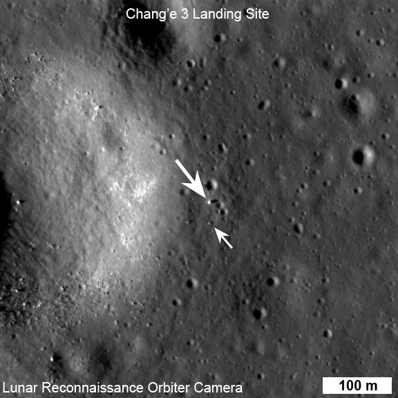
http://lroc.sese.asu.edu/news/index.php?/archives/849-Change-3-Lander-and-Rover-From-Above.html
Posted by: TheAnt Dec 30 2013, 10:22 PM
Nice, the lander stand out, but at least I would not figure which ones of those smaller dots were the rover unless it had been indicated.
Posted by: Phil Stooke Jan 1 2014, 09:08 PM
http://english.ihep.cas.cn/prs/ns/201312/t20131230_115114.html
APXS used just before shutdown! So now we know that every instrument on the rover (and as far as I know on the lander as well) has been tested during the first lunar day.
Phil
Posted by: 4th rock from the sun Jan 1 2014, 11:28 PM
Here's a quick overview of the mutual photography images released so far. For some we only have screencaps. In some cases I've assembled the larger original frames from the various zooms shown in videos.
It's not an artistic composition, but I think it helps in keeping track of things.
Images are grouped by the a, b, c and d stops shown on maps.

|
Posted by: Phil Stooke Jan 2 2014, 12:28 AM
That's very nice.
Phil
Posted by: Tom O'Reilly Jan 2 2014, 09:10 PM
My friends at Tsinghua University sent me the coolest Christmas toy ever - scale models of the Long March 3 launch vehicle, Chang'E lander, and Jade Rabbit rover. These are very cool - antenna booms and solar panel hinges articulate, rover wheels turn!

|
Posted by: elakdawalla Jan 2 2014, 09:33 PM
WANT  That is so cool. I would love to see a few more photos of that from different angles.
Posted by: Tom O'Reilly Jan 2 2014, 10:09 PM
That is so cool. I would love to see a few more photos of that from different angles.Landing configuration, before YuTu deployment. Philip J Fry is 16.5 cm tall, for scale

|
Posted by: Tom O'Reilly Jan 2 2014, 10:10 PM
YuTu close-up

|
Posted by: pospa Jan 2 2014, 10:11 PM
No problem Emily, look over http://www.ebay.com/itm/1-30-China-Change-YUTU-MOON-CAR-moon-Exploration-Model-EMS-FREE-SHIPPING-/111242034136?pt=Model_Kit_US&hash=item19e68abbd8. Or see even more Chang'e 3 / Yutu models http://www.ebay.com/sch/Models-Kits-/1188/i.html?_from=R40&_nkw=yutu
Posted by: Marvin Jan 3 2014, 01:02 PM
We have a result from the APXS carried by Yutu:
http://english.ihep.cas.cn/prs/ns/201312/t20131230_115114.html
Posted by: Gerald Jan 3 2014, 04:27 PM
So it seems, they take iron-55 and cadmium-109 as nuclides for APXS, with http://physics.nist.gov/cgi-bin/XrayTrans/search.pl?element=Ru&element=Rh&element=Pd&element=Ag&element=Cd&element=In&element=Sn&element=Sb&element=Te&element=I&element=Xe&element=Cs&element=Ba&element=La&trans=KL2&lower=15000&upper=25000&units=eV (from Ag-109 as http://en.wikipedia.org/wiki/Electron_capture "decay" product of http://en.wikipedia.org/wiki/Isotopes_of_cadmium) at 22keV responsible for the http://en.wikipedia.org/wiki/Rayleigh_scattering and http://en.wikipedia.org/wiki/Compton_scattering x-rays, and excited Mn from decaying http://en.wikipedia.org/wiki/Isotopes_of_iron responsible for the additional Mn K-alpha and Mn K-beta lines.
"esc" probably means "escape peaks", detector artifacts.
Posted by: TheAnt Jan 4 2014, 05:04 PM
That spectra is KREEP-y.
(Sorry couldn't resist.)
Posted by: stone Jan 6 2014, 01:18 PM
Funny to see that they use similar isotopes like the Viking X Ray Fluorescence Experiment.
http://nssdc.gsfc.nasa.gov/nmc/experimentDisplay.do?id=1975-075C-13
10.1029/JS082i028p04577
Posted by: Greenish Jan 7 2014, 03:18 PM
For what it's worth, for a question re daylight hours for Chang'e-3 on the NSF forum, I used the JPL Horizons web interface and the coordinates from the LROC team (44.1214°N, 340.4884°E, 2640 meters elevation). This gives the following RTS (Rise, Transit, Set) times for the sun at Chang'e-3 site as follows for one year from Dec 2013.
(Note this refers to the geometric horizon defined by the reference ellipsoid (doesn't take terrain into account) but should be good within a few minutes at worst.) I'm sure many here have to tools to do as well or better but figured I'd post it for reference.
****************************************
2013-Dec-11 15:39 *r 88.2308 -0.2697
2013-Dec-19 04:38 *t 180.1299 47.1462
2013-Dec-26 17:35 s 272.1149 -0.2745
2014-Jan-10 05:28 *r 87.6417 -0.2674
2014-Jan-17 19:08 *t 180.0261 47.4570
2014-Jan-25 08:35 s 272.3790 -0.2736
2014-Feb-08 20:01 *r 87.6683 -0.2695
2014-Feb-16 09:23 *t 179.9142 47.3069
2014-Feb-23 22:20 s 272.0071 -0.2702
2014-Mar-10 10:49 *r 88.3043 -0.2645
2014-Mar-17 22:59 *t 179.8359 46.7513
2014-Mar-25 10:37 s 271.1326 -0.2677
2014-Apr-09 01:15 *r 89.3338 -0.2645
2014-Apr-16 11:44 *t 179.8155 45.9660
2014-Apr-23 21:39 s 270.0287 -0.2697
2014-May-08 14:53 *r 90.4598 -0.2622
2014-May-15 23:39 *t 179.8403 45.1774
2014-May-23 07:55 s 268.9939 -0.2649
2014-Jun-07 03:30 *r 91.3783 -0.2578
2014-Jun-14 10:59 *t 179.9134 44.5936
2014-Jun-21 18:06 s 268.3079 -0.2679
2014-Jul-06 15:07 *r 91.8526 -0.2584
2014-Jul-13 22:04 *t 180.0097 44.3596
2014-Jul-21 04:47 s 268.1288 -0.2662
2014-Aug-05 02:00 *r 91.7720 -0.2594
2014-Aug-12 09:16 *t 180.0987 44.5335
2014-Aug-19 16:28 s 268.5118 -0.2671
2014-Sep-03 12:34 *r 91.1504 -0.2633
2014-Sep-10 20:58 *t 180.1791 45.0770
2014-Sep-18 05:24 s 269.3683 -0.2673
2014-Oct-02 23:22 *r 90.1449 -0.2617
2014-Oct-10 09:24 *t 180.2062 45.8564
2014-Oct-17 19:34 s 270.4885 -0.2705
2014-Nov-01 10:54 *r 89.0064 -0.2668
2014-Nov-08 22:42 *t 180.1828 46.6625
2014-Nov-16 10:36 s 271.5589 -0.2699
2014-Nov-30 23:36 *r 88.0716 -0.2645
Posted by: Mr Valiant Jan 7 2014, 06:21 PM
Hurry up Sun
Posted by: Phil Stooke Jan 7 2014, 07:04 PM
Yes! One downside (like we needed another downside!) of waiting 37 years for another landing on the Moon is that we have forgotten what it was like to have to wait 2 weeks for the sun to rise.
It's almost as cold here in Ontario today as it is up there in Mare Imbrium. This joke now officially recycled from the much more comfortable Mars.
Phil
Posted by: kenny Jan 8 2014, 09:42 PM
Seems a long 2 weeks - watching that danged terminator creep leftwards night after night, like a snail. Almost there now...
Posted by: Astro0 Jan 9 2014, 07:29 AM
Or to the right for those of us in the Southern Hemisphere
Posted by: kenny Jan 9 2014, 10:39 AM
Indeed! We mustn't be hemispherically prejudiced...
Posted by: Phil Stooke Jan 9 2014, 10:53 AM
It's OK, Astro0... the terminator on the far side was moving to the left. You couldn't see it, but it was. It all depends on which hemisphere you are thinking of!
Phil
Posted by: PaulH51 Jan 9 2014, 12:00 PM
Phil
Or you could live a couple of degrees from the equator (like me) which throws a whole new light on the subject... pun intended
Paul
Posted by: Thorsten Denk Jan 10 2014, 06:31 AM
Sunrise is NOW!
Thorsten
Posted by: craigmcg Jan 10 2014, 11:05 AM
Therefore we must now be on the "second lunar day?" Goodbye to this thread?
Posted by: Cosmic Penguin Jan 10 2014, 12:40 PM
More photos released, including the long-awaited "Earthshot" and top projected panorama from the lander and rover!
(in Chinese) http://slide.news.sina.com.cn/c/slide_1_2841_40326.htm
Posted by: PaulH51 Jan 10 2014, 12:51 PM
(in Chinese) http://slide.news.sina.com.cn/c/slide_1_2841_40326.htm
I dont think you can load direct from that link.... Try this http://slide.news.sina.com.cn/then select the ChangE3 image (01/10 17:51)
EDIT - Great images... thanks for sharing
Posted by: MahFL Jan 10 2014, 02:59 PM
EDIT - Great images... thanks for sharing
Be careful if your at work, a pic of a women on her knees was on that page...
Posted by: Phil Stooke Jan 10 2014, 03:02 PM
Yes, they are great images. I have manipulated the end of day panorama to come up with these different views:
|
|
|
The large pointy rock west of the rover, said to be a target for analysis soon, is mostly shaded at the left edge of the circular version.
Phil
Posted by: Phil Stooke Jan 10 2014, 03:50 PM
And here's the other pan in cylindrical and my circular version. Thanks to ... the source of the images, whoever that is.
|
|
|
Phil
Posted by: Explorer1 Jan 10 2014, 03:58 PM
And Earth turned out to be just as expected; not much difference from a deep space shot at the same distance! (Google Translate of the caption says something about '15 points'; possibly 15 degrees from the horizon?)
Much better pictures of the landing gear and how far it's sunk into the regolith too.
Posted by: Cosmic Penguin Jan 10 2014, 04:19 PM
Much better pictures of the landing gear and how far it's sunk into the regolith too.
Nope, the caption said that the photo was taken by the lander's MastCam on December 25 at 02:15 BJT (18:15 UTC Dec. 24).

Posted by: 4th rock from the sun Jan 10 2014, 04:41 PM
Very nice indeed. Good to view the side shots of the lander in decent quality.
I notice that the images are still not fully calibrated (or perhaps not calibrated at all for these releases), as you can see a gradient on each individual image that composes the mosaic.
This source also has some of the UV images of Earth:
http://big5.xinhuanet.com/gate/big5/news.xinhuanet.com/photo/2014-01/10/c_125988104_11.htm
Posted by: PaulH51 Jan 10 2014, 08:23 PM
My bad, apologies to all.... I did not scroll down that far when I visited that web page....
Posted by: elakdawalla Jan 10 2014, 08:35 PM
The pictures are all in my blog now, so here is a "safe for work" link: http://www.planetary.org/blogs/emily-lakdawalla/2014/01100912-finally-some-high-quality-change3.html
Posted by: ollopa Jan 11 2014, 04:28 PM
I have attempted to reconstruct the picture based on the published time, using http://www.fourmilab.ch/earthview/vplanet.html and an 18:00 UTC MTSAT image.
|
Looking at GOES imagery of the prominent swirl near Antarctica, it's pretty clear to me that the Chang'e picture was taken quite a bit earlier than 18:15 UTC. I would guess about 15:30 UTC based on where the terminator is with respect to the swirl.
Posted by: Phil Stooke Jan 20 2014, 04:07 AM
That was not the only Earth image. This newscast:
http://news.sohu.com/s2013/change/
includes three views of Earth:

|
Phil
Posted by: kenny Jan 20 2014, 11:43 AM
Website complete with banner heading showing Yutu incongruously trundling over the southern Oceanus Procellarum !
Posted by: Cosmic Penguin Jan 20 2014, 03:39 PM
Can you clarify what you are meaning?
Posted by: 4th rock from the sun Jan 20 2014, 03:43 PM
I think the comment is about the animated header on the site http://news.sohu.com/s2013/change/
Posted by: kenny Jan 20 2014, 04:51 PM
As '4th rock' says, the post was referring to the animation at the top of that web page. It shows Yutu in motion, but it is travelling on the wrong part of the moon, an area in the south of the Oceanus
Procellarum. I'm sure it is just the web designer's flair - not intended to be accurate.
Posted by: general Jan 22 2014, 07:29 AM
360° panorama
http://www.360cities.net/image/lunar-panorama-change-3-lander#81.50,1.58,110.0
Posted by: pospa Jan 22 2014, 09:37 AM
Isn't Earth in that panorama in the wrong place? Shouldn't be south of the lander instead of north?
Posted by: Thorsten Denk Jan 22 2014, 09:39 AM
Hm, there is some confusion with the orientation.
The rover left the lander towards the north, not south.
And the Earth should be in the opposite direction,
and higher above the horizon...
And the sun...
But besides these points, it's nice to move within the panorama.
Thorsten
Posted by: Paolo Feb 13 2014, 06:27 AM
this image from one of the TV reports has been posted on a French forum
http://www.servimg.com/image_preview.php?i=398&u=17604920
I think we have never seen it before, and it looks like a perspective from late on the first lunar day
EDIT: I post the image below because I don't trust these image hosting sites...

|
Posted by: Hungry4info Feb 13 2014, 12:16 PM
That hazcam image appears to show the arm deployed. I wonder if this was taken around the time that the first APXS spectrum of the lunar soil was obtained.
Posted by: dilo Feb 13 2014, 03:44 PM
Thanks Paolo for the image!
The news about Yutu signal detection, after initial unsuccessful attempt on Monday, is intriguing... could it be related to the late wake-up of the lander who received the rover signal and re-directed it to Earth?
Posted by: dvandorn Feb 13 2014, 05:56 PM
I believe the Chinese deserve many kudos for achieving what they have managed to achieve on this flight. Historically, a given country's first attempt at a specific type of mission is not completely successful. Just in terms of lunar probes, the first Soviet and American missions failed (either partially or completely) on the order of four times out of five.
Granted, the Chinese are somewhat standing on the shoulders of giants, the state-of-the-art being so much more advanced now in so many of the fields (electronics, communication, propulsion, etc.) that must come together for a mission like this to succeed. But that has historically been true for every other "first" attempt at a given mission. The very first people to try something are always stepping into the unknown.
However, I am positive the Chinese will learn from Chang'e 3's failures as well as its successes, and we are likely to see a more robust unmanned lunar exploration program as a result.
Even if we don't get any more beautiful images from Yutu, I'm impressed with the capability displayed. And I'm already looking forward to seeing what Chang'e 4 will accomplish.
-the other Doug
Posted by: Hungry4info Feb 13 2014, 06:39 PM
Chang'e 4 may not actually fly.
http://forum.nasaspaceflight.com/index.php?topic=7058.msg1155940#msg1155940
Posted by: A.Nemo Feb 14 2014, 06:07 AM
http://forum.nasaspaceflight.com/index.php?topic=7058.msg1155940#msg1155940
According to latest presentation:
http://www.oosa.unvienna.org/oosa/en/COPUOS/stsc/2014/presentations.html
The progress and achievement of Chang'e-3
Q. Wang, China Powerpoint Presentation
Chang'e 4 will launched in 2016
|
Posted by: Phil Stooke Feb 14 2014, 01:30 PM
Right... and that link (which looks more like someone's opinion rather than official policy) did say 'if CE3 is successful...' So I would say a CE4 mission that tries to solve the Yutu problems is very likely.
Phil
Posted by: tedstryk Feb 14 2014, 07:02 PM
Probably depends on if they can solve the problem on Yutu.
Posted by: Paolo Mar 4 2014, 05:57 PM
in the latest issue of the Chinese Journal of Space Science: http://www.cjss.ac.cn/EN/abstract/abstract2024.shtml
the full paper is not yet available, but it should be in a few days
Posted by: Paolo Mar 19 2014, 10:11 AM
the full paper (in Chinese) is now available. and it looks very interesting
Posted by: Paolo Apr 19 2014, 07:12 AM
this paper includes a few examples of left-right navcam images that I don't think we had seen yet: http://info.scichina.com:8084/sciF/CN/abstract/abstract514193.shtml
Posted by: Paolo May 10 2014, 03:30 PM
its companion paper http://www.cjss.ac.cn/EN/abstract/abstract2038.shtml is now published
Posted by: Paolo Jun 10 2014, 09:24 AM
I have found this image from Yutu linked in a Russian forum. I think it's from the first lunar day
edit: I have attached the image to the post, in case it disappears...
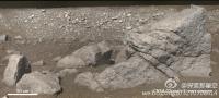
|
Posted by: Phil Stooke Jun 10 2014, 12:09 PM
That can only be the large 'pyramid' rock which was approached during the second day. On my map I showed the rover near it on January 14th and 15th - keep in mind the dates are assumptions and might not be exactly correct. The picture had to be taken on one of those two days.
Phil
Powered by Invision Power Board (http://www.invisionboard.com)
© Invision Power Services (http://www.invisionpower.com)