Opportunity Route Map |

  |
Opportunity Route Map |
 Sep 25 2008, 02:16 PM Sep 25 2008, 02:16 PM
Post
#2341
|
|
 Senior Member  Group: Members Posts: 4246 Joined: 17-January 05 Member No.: 152 |
And, we don't actually know that we're heading directly south from Vicky, so perhaps an intermediate step to reduce map size would be to just include Victoria (plus part of the anulus), if you weren't planning that already, Tesheiner...?
|
 |
 
|
|
Sep 25 2008, 04:18 PM
Post
#2342
|
|
|
Member Group: Members Posts: 279 Joined: 19-August 07 Member No.: 3299 |
Besides, we must use an HiRsE images from MRO websites for a detailed map of the planned route. The posted map at this forum with 1m/pixel will be enough as an navigation guide. However it would not be enough for studying the best path to Endeavour route. For simplicity, it is ideal to have the link to that HiRsE image in this forum at every map posting of Opportunity travel.
|
|
|
|
|
Sep 26 2008, 05:30 AM
Post
#2343
|
|
 Senior Member Group: Members Posts: 2228 Joined: 1-December 04 From: Marble Falls, Texas, USA Member No.: 116 |
That sounds like a workable suggestion to me. It should allow the frequently updated map to be significantly smaller than the current one, while providing a convenient link to a larger image hosted elsewhere. I think most of us following the mission progress will have little trouble relating the route map to the HiRise images, and it should be less work for Eduardo, too.
 ...but as the person committed to making these maps, only he knows the best way to do it. ...but as the person committed to making these maps, only he knows the best way to do it. 
-------------------- ...Tom
I'm not a Space Fan, I'm a Space Exploration Enthusiast. |
|
|
|
|
Sep 26 2008, 08:10 AM
Post
#2344
|
|
|
Senior Member Group: Moderator Posts: 4279 Joined: 19-April 05 From: .br at .es Member No.: 253 |
Thanks for all suggestions! The outcome is that I decided to change the map scale to 1m/pix and start it covering an area of 1km x 2km which I think is a good balance between resolution and file size (and the capabilities of my computer too!). Besides, instead of switching the background from time to time I'll try to cover more and more ground as the rover adds kms to its odometer; due to that I'm planning to post the whole map only eventually and use smaller snapshots for the "daily business".
Currently I'm using TRA_000873_1780_RED as the background but it doesn't cover the ground 'till Mini-Endurance so it would be better to switch it by PSP_009141_1780_RED which is the one being used for terrain evaluation on the other thread. It's a pity that small data drop (?) near Mini-Endurance on the latter picture but I suppose we will have new HiRISE images from that area and further south in the near future. |
|
|
|
|
Sep 26 2008, 10:17 AM
Post
#2345
|
||
|
Senior Member Group: Moderator Posts: 4279 Joined: 19-April 05 From: .br at .es Member No.: 253 |
I'll work on the above during the weekend.
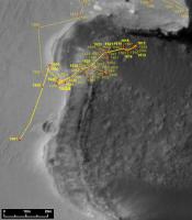
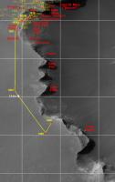
Meanwhile and sticking to the current map, here's an update after driving on sol 1661. I have no visual clue because the images didn't hit the exploratorium yet, but based on the mobility data from the rover, here's the latest position past Sputnik.
|
|
|
|
|
|
| Guest_Oersted_* |
Sep 26 2008, 12:32 PM
Post
#2346
|
|
Guests |
QUOTE (Tesheiner @ Sep 26 2008, 12:17 PM)  past Sputnik. 
|
|
|
|
|
Sep 28 2008, 08:49 PM
Post
#2347
|
|
|
Senior Member Group: Members Posts: 2920 Joined: 14-February 06 From: Very close to the Pyrénées Mountains (France) Member No.: 682 |
Eduardo,
I was trying to find out where 153 m south will put Oppy and I realized that the actual scale is no longer easy in the horizontal position as well as, at 100 meters, it'll may be going to be a bit too short! As usual, if you agree on this remark you'll may be consider it. BTW, I'm very excited thinking about the route maps to come. -------------------- |
|
|
|
|
Sep 29 2008, 08:03 AM
Post
#2348
|
||
|
Senior Member Group: Moderator Posts: 4279 Joined: 19-April 05 From: .br at .es Member No.: 253 |
Well, at the end I'm keeping the map scale at 0.5m/pix.
After making a new version at 1m/pix I realized that most of the small features (e.g. small ripples, tiny craters and rocky patches) in the image I used as reference to plot or double-check a position were gone  so I''m sticking to the good-old resolution but covering 1km x 2km. The zoom window is hidden; there is no reason to keep it with these long drives. so I''m sticking to the good-old resolution but covering 1km x 2km. The zoom window is hidden; there is no reason to keep it with these long drives.Here's the map updated after the long drive during sol 1663. The position is preliminar (based only on the rover's mobility data) still to be double-checked once the navcam images hit the ground.
|
|
|
|
|
|
|
Sep 29 2008, 09:47 AM
Post
#2349
|
|
|
Senior Member Group: Members Posts: 2920 Joined: 14-February 06 From: Very close to the Pyrénées Mountains (France) Member No.: 682 |
Very handy new grid Eduardo, thanks for this idea.
-------------------- |
|
|
|
|
Sep 29 2008, 06:27 PM
Post
#2350
|
|
|
Member Group: Members Posts: 235 Joined: 2-August 05 Member No.: 451 |
QUOTE (Tesheiner @ Sep 29 2008, 02:03 AM) Here's the map updated after the long drive during sol 1663. Oddly, the map calls 1663 1163. |
|
|
|
|
Sep 29 2008, 06:39 PM
Post
#2351
|
|
|
Member Group: Members Posts: 530 Joined: 21-March 06 From: Canada Member No.: 721 |
Nothing odd about typos, it just requires correction
|
|
|
|
|
Sep 29 2008, 07:57 PM
Post
#2352
|
|
|
Senior Member Group: Moderator Posts: 4279 Joined: 19-April 05 From: .br at .es Member No.: 253 |
Thanks for the heads up. I'll correct it on the next update.
|
|
|
|
|
Oct 1 2008, 11:42 AM
Post
#2353
|
||
|
Senior Member Group: Moderator Posts: 4279 Joined: 19-April 05 From: .br at .es Member No.: 253 |
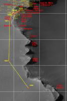
Sol 1666; another long drive.
Edited: Corrected position at sol 1663 a few meters to the south based on the navcam pictures. |
|
|
|
|
|
|
Oct 2 2008, 07:55 AM
Post
#2354
|
||
|
Senior Member Group: Moderator Posts: 4279 Joined: 19-April 05 From: .br at .es Member No.: 253 |
From september's issue of the monthly MER Update at TPS:
QUOTE Our goal is to drive right past Cape Pelar (sic) to the north end of Cape Victory Magellan would have called it Cabo Victoria -- and then imaging Cape Pelar (sic) which is the next promontory, Squyres said. Thats our objective for the next few sols. Then were going to the next promontory to the south and image across of the southern side of Cape Victory. And then, were going to hit the gas. This is how I understand it.
|
|
|
|
|
|
|
Oct 3 2008, 08:17 AM
Post
#2355
|
||
|
Senior Member Group: Moderator Posts: 4279 Joined: 19-April 05 From: .br at .es Member No.: 253 |
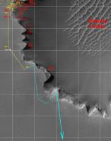
Another update, after driving on sol 1668.
|
|
|
|
|
|
|

|
Lo-Fi Version | Time is now: 26th April 2024 - 09:48 AM |
|
RULES AND GUIDELINES Please read the Forum Rules and Guidelines before posting. IMAGE COPYRIGHT |
OPINIONS AND MODERATION Opinions expressed on UnmannedSpaceflight.com are those of the individual posters and do not necessarily reflect the opinions of UnmannedSpaceflight.com or The Planetary Society. The all-volunteer UnmannedSpaceflight.com moderation team is wholly independent of The Planetary Society. The Planetary Society has no influence over decisions made by the UnmannedSpaceflight.com moderators. |
SUPPORT THE FORUM Unmannedspaceflight.com is funded by the Planetary Society. Please consider supporting our work and many other projects by donating to the Society or becoming a member. |
|