Cape York - The "Lakelands", Starting sol 2703 |

  |
Cape York - The "Lakelands", Starting sol 2703 |
 Sep 29 2011, 11:23 PM Sep 29 2011, 11:23 PM
Post
#166
|
|
 Dublin Correspondent  Group: Admin Posts: 1799 Joined: 28-March 05 From: Celbridge, Ireland Member No.: 220 |
Possibly the best double act comment pair on the site, ever...
|
 |
 
|
|
Sep 30 2011, 01:01 AM
Post
#167
|
|
|
Senior Member Group: Members Posts: 1582 Joined: 14-October 05 From: Vermont Member No.: 530 |
QUOTE (helvick @ Sep 29 2011, 07:23 PM)  Possibly the best double act comment pair on the site, ever... Call it the Burns formation. |
|
|
|
|
Sep 30 2011, 10:17 AM
Post
#168
|
|
|
Senior Member Group: Members Posts: 2998 Joined: 30-October 04 Member No.: 105 |
"Say goodnight, Gracie..."
Supposedly Oppy will be doing a MB integration at Salibury for a few days, but in the pipeline are images of the Next Drive Direction (P2397) and a super-res image set at Sutherland Point (presumably the post-C.York target). --Bill -------------------- |
|
|
|
|
Sep 30 2011, 01:34 PM
Post
#169
|
|
|
Junior Member Group: Members Posts: 98 Joined: 17-July 11 From: Pasadena, CA Member No.: 6066 |
Yeah, there's a veritable fork in the road today and Monday. They are possibly going to simply "rinse and repeat" the last few sols' plans of MB integrations, since we get two "free" sols of it when we make the weekend plans on Fridays. There seems to be agreement that we shouldn't drive away just yet. Monday is likely going to be a "clean up and drive off" day.
-m |
|
|
|
|
Sep 30 2011, 02:21 PM
Post
#170
|
|
|
Senior Member Group: Members Posts: 2998 Joined: 30-October 04 Member No.: 105 |
Agreed, the in-place bedrock nearby appears to be similar to Salisbury so Oppy's done all that can be done at this location. They might want to zap the RAT hole with the MB for a longer integration time, but that's all. They need to work their way up-hill to the next outcrop on the way to the CRISM clays near the "summit crater". Geologically there was so much happening here that moving a short distance up in the section will put us in a whole 'nuther sequence of events.
--Bill -------------------- |
|
|
|
|
Oct 1 2011, 06:52 PM
Post
#171
|
||
|
Senior Member Group: Members Posts: 2823 Joined: 22-April 05 From: Ridderkerk, Netherlands Member No.: 353 |
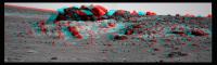
The L2 Pancam view on Sol 2732.
Jan van Driel
|
|
|
|
|
|
|
Oct 1 2011, 07:58 PM
Post
#172
|
||
 Member Group: Members Posts: 691 Joined: 21-December 07 From: Clatskanie, Oregon Member No.: 3988 |
Some really facinating topography here

|
|
|
|
|
|
|
Oct 1 2011, 08:17 PM
Post
#173
|
|
 Senior Member Group: Members Posts: 4247 Joined: 17-January 05 Member No.: 152 |
I see you added some shear to the images to "flatten out" the anaglyph, James. Did you do that by hand, or using some automated routine?
|
|
|
|
|
Oct 1 2011, 09:24 PM
Post
#174
|
|
|
Solar System Cartographer Group: Members Posts: 10159 Joined: 5-April 05 From: Canada Member No.: 227 |
That's quite the anaglyph! I wouldn't want to try driving over it if that was the real topography...
Phil -------------------- ... because the Solar System ain't gonna map itself.
Also to be found posting similar content on https://mastodon.social/@PhilStooke Maps for download (free PD: https://upload.wikimedia.org/wikipedia/comm...Cartography.pdf NOTE: everything created by me which I post on UMSF is considered to be in the public domain (NOT CC, public domain) |
|
|
|
|
Oct 1 2011, 10:28 PM
Post
#175
|
||
 The Poet Dude Group: Moderator Posts: 5551 Joined: 15-March 04 From: Kendal, Cumbria, UK Member No.: 60 |
Colourised sol 2732 panorama...
Full size version on my RtE blog later. -------------------- |
|
|
|
|
|
|
Oct 1 2011, 11:04 PM
Post
#176
|
|
|
Founder Group: Chairman Posts: 14432 Joined: 8-February 04 Member No.: 1 |
It's important to differentiate between color and colorized. That mosaic, Stu - is color. Taking a Navcam pan and tinting it orange would be colorized.
One creates something with more information than the component parts alone, the other, technically, reduces it. Yours - importantly - is the former. |
|
|
|
|
Oct 1 2011, 11:11 PM
Post
#177
|
||
|
The Poet Dude Group: Moderator Posts: 5551 Joined: 15-March 04 From: Kendal, Cumbria, UK Member No.: 60 |
You're right, my mistake. Long, not particularly clean day at work, knackered, meant to say colour.
Fascinating place, Cape York, isn't it? And we were worried it would be a flat, featureless "Nothing to see here, move along" kind of place. Looking forward to looking back down on it from halfway up Tribulation one day... Edit: 3D crop view...
-------------------- |
|
|
|
|
|
|
Oct 2 2011, 05:08 AM
Post
#178
|
|
|
Member Group: Members Posts: 691 Joined: 21-December 07 From: Clatskanie, Oregon Member No.: 3988 |
QUOTE (fredk @ Oct 1 2011, 12:17 PM) Did you do that by hand, or using some automated routine? I used the warp transform in Photoshop to manually align the red channel (left eye) with features in right eye. |
|
|
|
|
Oct 2 2011, 12:00 PM
Post
#179
|
|
|
Solar System Cartographer Group: Members Posts: 10159 Joined: 5-April 05 From: Canada Member No.: 227 |
Ah - that is why the result has some dramatic wavy distortions in it.
Phil -------------------- ... because the Solar System ain't gonna map itself.
Also to be found posting similar content on https://mastodon.social/@PhilStooke Maps for download (free PD: https://upload.wikimedia.org/wikipedia/comm...Cartography.pdf NOTE: everything created by me which I post on UMSF is considered to be in the public domain (NOT CC, public domain) |
|
|
|
|
Oct 2 2011, 01:41 PM
Post
#180
|
|
|
Senior Member Group: Members Posts: 2998 Joined: 30-October 04 Member No.: 105 |
Here are some images I've worked up whilst musing the delivery of a set of "Next Drive Direction" Pancams last week.
First off is a recent HiRISE image of Cape York showing Oppy at the Chester Lake outcrop. Annotated, it shows Oppy as R, possible site "Skead Kirkland Lake" as 1, possible site "BostonCreek LarderLake" as 2 and an unidentified rock pile seen on the horizon of the drive direction panorama as 3. The dashed yellow line is simply the observed "trend" in the outcrops seen in the aerials-- the strata on the rim of crater Endeavour are tilted or uplifted and dip towards the northwest. Features aligned along this trend direction are likely of a similar age and, although there may be differences in the rocks, they are linked by time of formation. Strata downhill will be older and strata uphill will be younger in age. As a general rule, more-or-less. http://i142.photobucket.com/albums/r91/wil...-2730-annot.jpg http://i142.photobucket.com/albums/r91/wil...97L2M1-pano.jpg The outcrop Skead Kirkland Lake is one we've drooled at before and is an interesting-looking exposure. Why is there an unusual purplish iridescent sheen to the rock? I'll guess it's a weathering phenomenon, which is the important step in turning silicate rocks into clays. Wouldn't hurt to have a closer look-- not necessarily a full IDD session, but a series of close-in Pancams would be peachy. http://i142.photobucket.com/albums/r91/wil...19P2398L2M1.jpg Next would be the outcrop BostonCreek LarderLake **. Along the trend-timeline as Skead, but why is it different? Look at the number of beds seen in this outcrop. Whereas most of the rocks seen here have been a massive impact breccia (apparently), this unit is more finely bedded, which implies different depositional processes were at work here. And just over the hill is the "summit crater" with the CRISM clays scattered about, so "Boston" is a important puzzle piece. I tried to merge the color information with the grayscale detail, but couldn't get it to work out, so here are two similar but different views. http://i142.photobucket.com/albums/r91/wil...P2540L2M1-1.jpg http://i142.photobucket.com/albums/r91/wil...1--crop-enh.jpg --Bill ** "BostonCreek LarderLake" has been named Shoemaker Ridge (after Gene Shoemaker, a planetary geologist). -------------------- |
|
|
|
|

|
Lo-Fi Version | Time is now: 6th May 2024 - 04:56 PM |
|
RULES AND GUIDELINES Please read the Forum Rules and Guidelines before posting. IMAGE COPYRIGHT |
OPINIONS AND MODERATION Opinions expressed on UnmannedSpaceflight.com are those of the individual posters and do not necessarily reflect the opinions of UnmannedSpaceflight.com or The Planetary Society. The all-volunteer UnmannedSpaceflight.com moderation team is wholly independent of The Planetary Society. The Planetary Society has no influence over decisions made by the UnmannedSpaceflight.com moderators. |
SUPPORT THE FORUM Unmannedspaceflight.com is funded by the Planetary Society. Please consider supporting our work and many other projects by donating to the Society or becoming a member. |
|