Journey to Mt Sharp - Part 1: Site 7 to Waypoint 1, Sol324 [Jul4,'13] to Sol391 [Sep12,'13] |

  |
Journey to Mt Sharp - Part 1: Site 7 to Waypoint 1, Sol324 [Jul4,'13] to Sol391 [Sep12,'13] |
 Jul 10 2013, 12:49 PM Jul 10 2013, 12:49 PM
Post
#31
|
|
 Senior Member  Group: Members Posts: 1619 Joined: 12-February 06 From: Bergerac - FR Member No.: 678 |
Sol 328 Navcam pan.
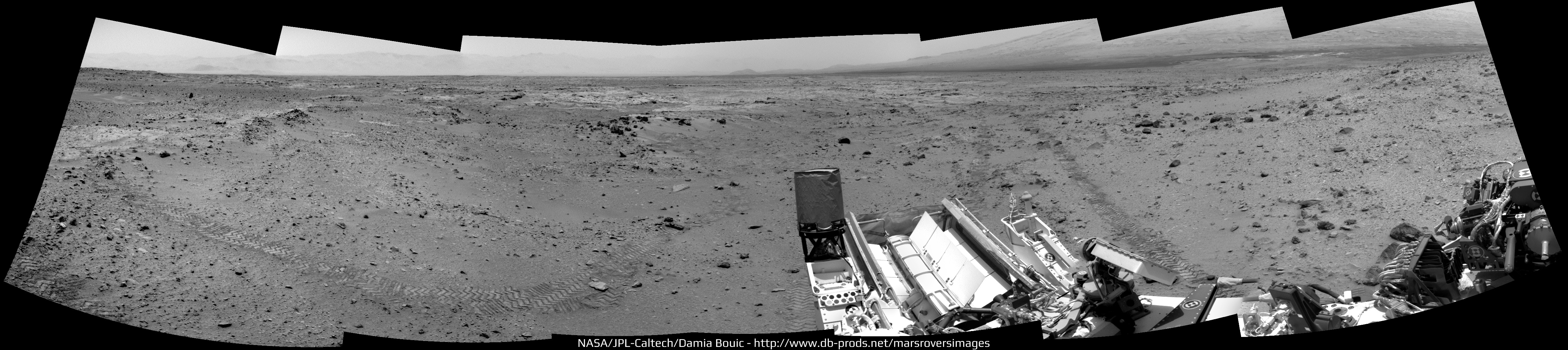 I'm pretty sure we can see Rocknest near the left-center of the panorama  . .
-------------------- |
 |
 
|
|
Jul 10 2013, 01:28 PM
Post
#32
|
||
|
Solar System Cartographer Group: Members Posts: 10151 Joined: 5-April 05 From: Canada Member No.: 227 |
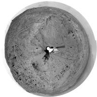
Yes, that's Rocknest. This is the back half of the previous pan, making a full 360 degrees before they drove on later in the sol.
Here's a full 360 in a circular projection:
Phil -------------------- ... because the Solar System ain't gonna map itself.
Also to be found posting similar content on https://mastodon.social/@PhilStooke Maps for download (free PD: https://upload.wikimedia.org/wikipedia/comm...Cartography.pdf NOTE: everything created by me which I post on UMSF is considered to be in the public domain (NOT CC, public domain) |
|
|
|
|
|
|
Jul 10 2013, 06:17 PM
Post
#33
|
|
|
Senior Member Group: Members Posts: 2346 Joined: 7-December 12 Member No.: 6780 |
QUOTE (Actionman @ Jul 10 2013, 01:23 PM)  "If" being the key word. "IF" the dark dune is segregated basalt sand, where is the basalt the sand coming from? directly under the dune? Most of it from distant locations, probably from outside Gale Crater where basaltic bedrock is more abundant. |
|
|
|
|
Jul 10 2013, 06:43 PM
Post
#34
|
|
|
Senior Member Group: Members Posts: 1619 Joined: 12-February 06 From: Bergerac - FR Member No.: 678 |
Good point Phil
So, here's the full pan, Sol 327 & 329 : 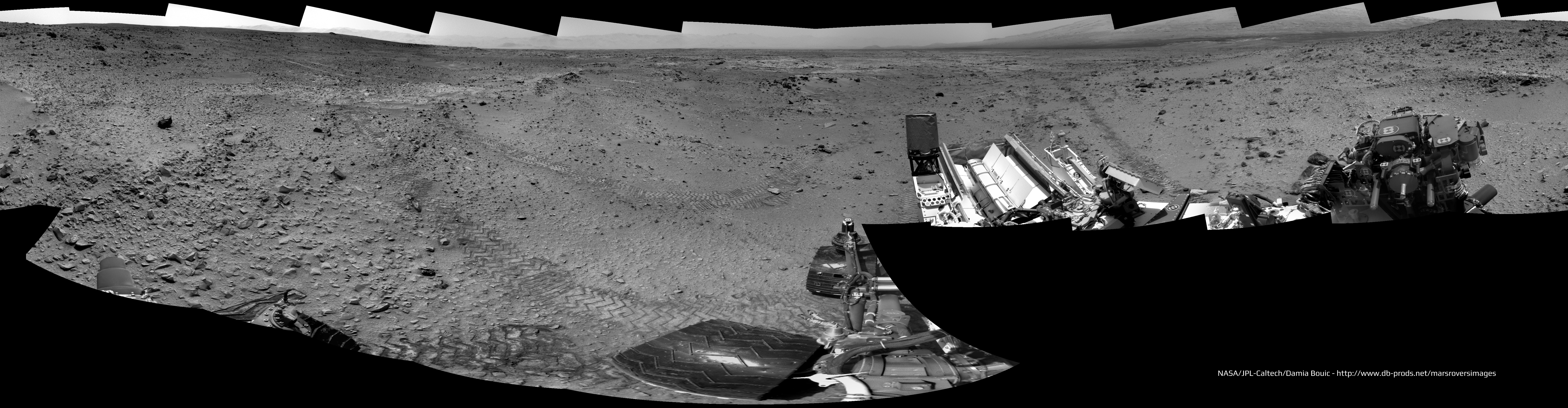
-------------------- |
|
|
|
|
Jul 10 2013, 07:49 PM
Post
#35
|
|
 Senior Member Group: Members Posts: 3419 Joined: 9-February 04 From: Minneapolis, MN, USA Member No.: 15 |
In re the dark dunes, they remind me of El Dorado in Gusev. That dark dune field, while much smaller than the ones ringing Mt. Sharp, looked as dark from a distance and from above as the ones here in Gale. When we got really close to El Dorado, we found there is a thin layer of the ubiquitous red dust on the mini-dune ridges, but it's mostly just black basaltic dust.
I would imagine these dark dunes in Gale formed by a similar process as that which created El Dorado, an area that is wind-shadowed in such a way that the black basaltic grains are preferentially dropped from the general airborne dust entrainment. Or, maybe not exactly a wind shadow, more of a place where Mt. Sharp's effect on the winds causes the exact right kind of instability in the air that causes the preferential deposition. The big difference between these extensive dune fields here at Gale and the El Dorado field in Gusev is that Mt. Sharp is a much bigger hill than Husband Hill was, so these dune fields are much larger and seem to show some differences in albedo (we'll know about textural differences when we get there), depending on how far away from Mt. Sharp you are (or maybe the angle of repose upon which the dunes formed; the two are sort of interrelated). Could be that the "edges" of the wind instability that causes the preferential deposition show a more well-mixed deposition? Again, something we will know more about when we get there. In any event, we see this effect literally everywhere on Mars, be it influenced by mountains, crater rims or whatever causes the right kind of instability that causes the preferential deposition. It's certainly not unique to Gale. -the other Doug -------------------- The trouble ain't that there is too many fools, but that the lightning ain't distributed right. -Mark Twain
|
|
|
|
|
Jul 10 2013, 08:47 PM
Post
#36
|
||
|
Solar System Cartographer Group: Members Posts: 10151 Joined: 5-April 05 From: Canada Member No.: 227 |
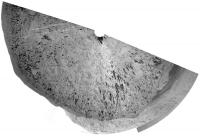
A very rough circular half-pan for the 329 location.
Phil
-------------------- ... because the Solar System ain't gonna map itself.
Also to be found posting similar content on https://mastodon.social/@PhilStooke Maps for download (free PD: https://upload.wikimedia.org/wikipedia/comm...Cartography.pdf NOTE: everything created by me which I post on UMSF is considered to be in the public domain (NOT CC, public domain) |
|
|
|
|
|
|
Jul 10 2013, 09:17 PM
Post
#37
|
|
|
Senior Member Group: Members Posts: 3516 Joined: 4-November 05 From: North Wales Member No.: 542 |
QUOTE (fredk @ Jul 9 2013, 11:51 PM) Nearby is a prominent two-toned hill A very interesting feature also. The dark grey patches look like avalanches that have broken through a brighter red crust, consistent perhaps with the hill being made of sand. Given that we believe Mars experiences big climatic swings it seems reasonable that there might be evidence of multiple eras of dune formation here, in this favoured location (as evidenced by the presence of an active dune system today). |
|
|
|
|
Jul 11 2013, 01:08 AM
Post
#38
|
|
 Member Group: Members Posts: 222 Joined: 7-August 12 From: Garberville, CA Member No.: 6500 |
Sol 329 - Hazcam Anaglyphs from new our position after the 41.05 meter afternoon drive. Tracks from the Sol 52 drive visible at upper right of front view....
Rear:  Front: 
-------------------- "We shall not cease from exploration, and the end of all our exploring will be to arrive where we started and know the place for the first time." -T.S. Eliot
|
|
|
|
|
Jul 11 2013, 01:24 PM
Post
#39
|
|
|
Senior Member Group: Members Posts: 1619 Joined: 12-February 06 From: Bergerac - FR Member No.: 678 |
Sol 329 Navcam pan (and the good one, I've made a mistake between 328 and 329
 ). ).
-------------------- |
|
|
|
|
Jul 12 2013, 11:28 AM
Post
#40
|
|
|
Senior Member Group: Members Posts: 1619 Joined: 12-February 06 From: Bergerac - FR Member No.: 678 |
Sol 331 Navcam pan :
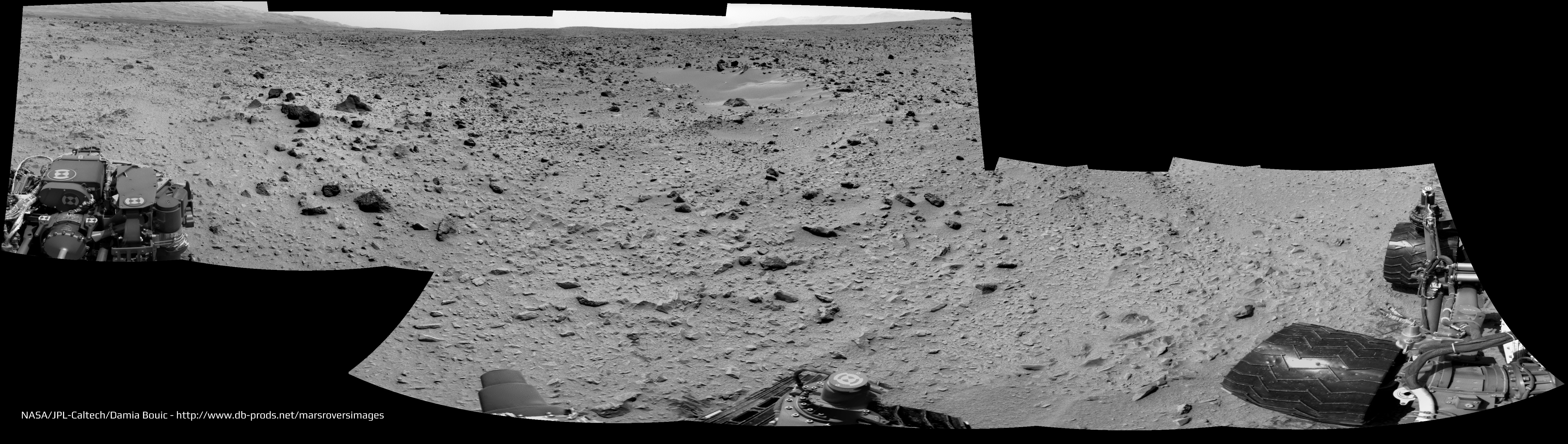 Isn't it Jake Matijeivic we can see near the horizon, at the center of the image ? -------------------- |
|
|
|
|
Jul 12 2013, 11:35 AM
Post
#41
|
|
 Senior Member Group: Members Posts: 2428 Joined: 30-January 13 From: Penang, Malaysia. Member No.: 6853 |
QUOTE (Ant103 @ Jul 12 2013, 07:28 PM) Isn't it Jake Matijeivic we can see near the horizon, at the center of the image ? It's in the correct position, nice observation Damia
|
|
|
|
|
Jul 12 2013, 01:01 PM
Post
#42
|
||
|
Solar System Cartographer Group: Members Posts: 10151 Joined: 5-April 05 From: Canada Member No.: 227 |
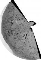
Looks like you're right, Damia.
Here's a circular version of that pan:
Phil PS - probably not on the next drive, but on the one after that, we will pass the 1 km mark. -------------------- ... because the Solar System ain't gonna map itself.
Also to be found posting similar content on https://mastodon.social/@PhilStooke Maps for download (free PD: https://upload.wikimedia.org/wikipedia/comm...Cartography.pdf NOTE: everything created by me which I post on UMSF is considered to be in the public domain (NOT CC, public domain) |
|
|
|
|
|
|
Jul 12 2013, 03:50 PM
Post
#43
|
||
 Senior Member Group: Members Posts: 4246 Joined: 17-January 05 Member No.: 152 |
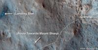
As you could guess from the sol 331 drive, the plan seems to be to divert south of the old route now. Here's a proposed route from the latest video update:
|
|
|
|
|
|
|
Jul 12 2013, 05:18 PM
Post
#44
|
|
|
Member Group: Members Posts: 222 Joined: 7-August 12 From: Garberville, CA Member No.: 6500 |
Onward! Looks like it's all new digs from here then. Here are post-drive Sol331 front and rear Hazcam Anaglyphs...
Front:  Rear:  ...and thanks as always Phil for the ongoing route map updates. Having the scale bar ( as suggested by charborob) is a really nice addition. -------------------- "We shall not cease from exploration, and the end of all our exploring will be to arrive where we started and know the place for the first time." -T.S. Eliot
|
|
|
|
|
Jul 13 2013, 09:45 AM
Post
#45
|
||
 Member Group: Members Posts: 215 Joined: 23-October 12 From: Russia Member No.: 6725 |
My try to make ChemCam panorana on Sol 327.
Attached thumbnail(s)
-------------------- My blog on Patreon
|
|
|
|
|
|
|

|
Lo-Fi Version | Time is now: 26th April 2024 - 01:40 PM |
|
RULES AND GUIDELINES Please read the Forum Rules and Guidelines before posting. IMAGE COPYRIGHT |
OPINIONS AND MODERATION Opinions expressed on UnmannedSpaceflight.com are those of the individual posters and do not necessarily reflect the opinions of UnmannedSpaceflight.com or The Planetary Society. The all-volunteer UnmannedSpaceflight.com moderation team is wholly independent of The Planetary Society. The Planetary Society has no influence over decisions made by the UnmannedSpaceflight.com moderators. |
SUPPORT THE FORUM Unmannedspaceflight.com is funded by the Planetary Society. Please consider supporting our work and many other projects by donating to the Society or becoming a member. |
|