Opportunity Route Map |

  |
Opportunity Route Map |
 Nov 3 2016, 12:13 AM Nov 3 2016, 12:13 AM
Post
#3436
|
||
|
Solar System Cartographer  Group: Members Posts: 10153 Joined: 5-April 05 From: Canada Member No.: 227 |
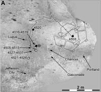
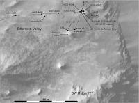
We must be nearing the end of activities at Spirit Mound. Here's an updated map.
Phil
-------------------- ... because the Solar System ain't gonna map itself.
Also to be found posting similar content on https://mastodon.social/@PhilStooke Maps for download (free PD: https://upload.wikimedia.org/wikipedia/comm...Cartography.pdf NOTE: everything created by me which I post on UMSF is considered to be in the public domain (NOT CC, public domain) |
|
 |
 
|
|
|
Nov 7 2016, 05:51 PM
Post
#3437
|
|||
|
Solar System Cartographer Group: Members Posts: 10153 Joined: 5-April 05 From: Canada Member No.: 227 |
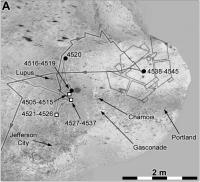
And we're off! Heading out on the next great adventure (AKA serious science).
Phil
-------------------- ... because the Solar System ain't gonna map itself.
Also to be found posting similar content on https://mastodon.social/@PhilStooke Maps for download (free PD: https://upload.wikimedia.org/wikipedia/comm...Cartography.pdf NOTE: everything created by me which I post on UMSF is considered to be in the public domain (NOT CC, public domain) |
||
|
|
|
||
|
Nov 9 2016, 05:41 PM
Post
#3438
|
||
|
Solar System Cartographer Group: Members Posts: 10153 Joined: 5-April 05 From: Canada Member No.: 227 |
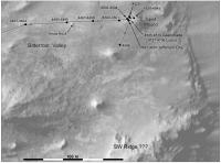
Another very small move on sol 4548.
Phil
-------------------- ... because the Solar System ain't gonna map itself.
Also to be found posting similar content on https://mastodon.social/@PhilStooke Maps for download (free PD: https://upload.wikimedia.org/wikipedia/comm...Cartography.pdf NOTE: everything created by me which I post on UMSF is considered to be in the public domain (NOT CC, public domain) |
|
|
|
|
|
|
Nov 11 2016, 03:56 PM
Post
#3439
|
||
|
Solar System Cartographer Group: Members Posts: 10153 Joined: 5-April 05 From: Canada Member No.: 227 |
Update to sol 4550, climbing uphill a bit around the base of the rocky hill.
Phil
-------------------- ... because the Solar System ain't gonna map itself.
Also to be found posting similar content on https://mastodon.social/@PhilStooke Maps for download (free PD: https://upload.wikimedia.org/wikipedia/comm...Cartography.pdf NOTE: everything created by me which I post on UMSF is considered to be in the public domain (NOT CC, public domain) |
|
|
|
|
|
|
Nov 12 2016, 03:58 PM
Post
#3440
|
|
|
Senior Member Group: Members Posts: 1276 Joined: 25-November 04 Member No.: 114 |
Im confused. I thought Jpl planning to drive up to features that resemble Gullies.
Is this still in plans? |
|
|
|
|
Nov 12 2016, 06:55 PM
Post
#3441
|
|
|
Member Group: Members Posts: 808 Joined: 10-October 06 From: Maynard Mass USA Member No.: 1241 |
Hey Decepticon,
Back of the envelope... The gully in question is about a half mile away ( call it 2600 feet -- as a Mars crow flies ) Opportunity has traversed 27 miles in 4550 sols ( an average of 31.3 feet per sol -- which is about half the distance down a bowling alley) So, OPPY can fly there in roughly 83 days -- about three months (mid Feb 2017) BUT... the actual distance OPPY will maneuver around 'mars stuff' will be 1.5X? (3,900 feet) - its kind of fractal-ly And there will be things JPL will want stop and investigate along the way. So the My best guess for the earliest arrival at the gully is 182 days (a full half year) Roughly May 15, 2017 -- and that is optimistic! (Dust storms, seasons, malfunctions, discoveries, you name it) It's still in the plans, it just takes awhile... Has JPL published any kind of dates for this adventure? (BTW: you and I could hike over there in less than an hour) -------------------- CLA CLL
|
|
|
|
|
Nov 13 2016, 01:33 AM
Post
#3442
|
|
|
Senior Member Group: Members Posts: 1276 Joined: 25-November 04 Member No.: 114 |
Wow Thanks for those details.

|
|
|
|
|
Nov 14 2016, 05:59 PM
Post
#3443
|
|
|
Newbie Group: Members Posts: 14 Joined: 25-August 09 Member No.: 4913 |
I'd like to make a request for the full Oppy traverse map from day one to today. Thanks ahead of time.
|
|
|
|
|
Nov 14 2016, 08:26 PM
Post
#3444
|
|
|
Solar System Cartographer Group: Members Posts: 10153 Joined: 5-April 05 From: Canada Member No.: 227 |
What you are asking for does not really exist. The closest you can get to a very detailed map of the whole route is (purely coincidentally) my book! Atlas of Mars Exploration, vol. 2 - alas, rather expensive. However, I might be able to make something that works for this. Let me think about it.
Phil -------------------- ... because the Solar System ain't gonna map itself.
Also to be found posting similar content on https://mastodon.social/@PhilStooke Maps for download (free PD: https://upload.wikimedia.org/wikipedia/comm...Cartography.pdf NOTE: everything created by me which I post on UMSF is considered to be in the public domain (NOT CC, public domain) |
|
|
|
|
Nov 14 2016, 08:40 PM
Post
#3445
|
|
|
Newbie Group: Members Posts: 14 Joined: 25-August 09 Member No.: 4913 |
I guess this was what I was looking for just for a frame of reference. Would be nice to get one of these every so often just to gauge full progress:

|
|
|
|
|
Nov 14 2016, 08:59 PM
Post
#3446
|
|
|
Solar System Cartographer Group: Members Posts: 10153 Joined: 5-April 05 From: Canada Member No.: 227 |
OK, I see what you mean. I thought you meant a much more detailed map.
Phil -------------------- ... because the Solar System ain't gonna map itself.
Also to be found posting similar content on https://mastodon.social/@PhilStooke Maps for download (free PD: https://upload.wikimedia.org/wikipedia/comm...Cartography.pdf NOTE: everything created by me which I post on UMSF is considered to be in the public domain (NOT CC, public domain) |
|
|
|
|
Nov 14 2016, 10:25 PM
Post
#3447
|
|
|
Member Group: Members Posts: 866 Joined: 15-March 05 From: Santa Cruz, CA Member No.: 196 |
In case you havent tried it, its worth mentioning that someone out there is still keeping the Oppy traverse path up to date:
Launch Google Earth and go to View > Explore > Mars, open the 'Layers" panel on left and open Mars Gallery > Rovers and Landers and double-click on "MER Opportunity Rover (USA)" |
|
|
|
|
Nov 14 2016, 10:25 PM
Post
#3448
|
|
|
Newbie Group: Members Posts: 14 Joined: 25-August 09 Member No.: 4913 |
More detail would be great but would have to be limited to inset blowups.
|
|
|
|
|
Nov 14 2016, 10:32 PM
Post
#3449
|
|
|
Newbie Group: Members Posts: 14 Joined: 25-August 09 Member No.: 4913 |
Thanks for the google earth tip!
|
|
|
|
|
Nov 15 2016, 01:31 AM
Post
#3450
|
||
|
Solar System Cartographer Group: Members Posts: 10153 Joined: 5-April 05 From: Canada Member No.: 227 |
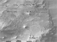
Map update to sol 4552, a small move near Pompy's Tower, probably to find a better path through the block field here.
Phil
-------------------- ... because the Solar System ain't gonna map itself.
Also to be found posting similar content on https://mastodon.social/@PhilStooke Maps for download (free PD: https://upload.wikimedia.org/wikipedia/comm...Cartography.pdf NOTE: everything created by me which I post on UMSF is considered to be in the public domain (NOT CC, public domain) |
|
|
|
|
|
|

|
Lo-Fi Version | Time is now: 27th April 2024 - 01:25 AM |
|
RULES AND GUIDELINES Please read the Forum Rules and Guidelines before posting. IMAGE COPYRIGHT |
OPINIONS AND MODERATION Opinions expressed on UnmannedSpaceflight.com are those of the individual posters and do not necessarily reflect the opinions of UnmannedSpaceflight.com or The Planetary Society. The all-volunteer UnmannedSpaceflight.com moderation team is wholly independent of The Planetary Society. The Planetary Society has no influence over decisions made by the UnmannedSpaceflight.com moderators. |
SUPPORT THE FORUM Unmannedspaceflight.com is funded by the Planetary Society. Please consider supporting our work and many other projects by donating to the Society or becoming a member. |
|