New Horizons Pluto System Final Approach, 28 Jun-13 Jul 15 |

  |
New Horizons Pluto System Final Approach, 28 Jun-13 Jul 15 |
 Jul 11 2015, 02:49 PM Jul 11 2015, 02:49 PM
Post
#541
|
|
 Member  Group: Members Posts: 423 Joined: 13-November 14 From: Norway Member No.: 7310 |
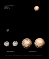
QUOTE (Paolo @ Jul 11 2015, 04:27 PM)  is the polygonal feature seen in yesterday's release the same area as the "donut" seen one week ago? Nah, the donut appears to have dissolved; figuratively speaking. I made this earlier today, and it should roughly be correct: 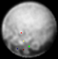 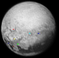  (not all possible pairings have been made) -------------------- |
 |
 
|
|
Jul 11 2015, 02:53 PM
Post
#542
|
|
|
Member Group: Members Posts: 153 Joined: 20-December 14 From: Eastbourne, UK Member No.: 7372 |
Really like the experimental method images ZLD. This recent set and the one before, it will be interesting to compare with later images. I'm thinking as mentioned some time back, the "Eyeball" planet.
Some thoughts. During the polar summer solid super volatiles such as Nitrogen, Neon, Carbon Monoxide, and possibly Methane, will start to sublimate and slowly sink towards the equator. As autumn approaches in the opposing sub equatorial regions those volatiles freeze, and over time build a ring of mountains around the tropics, one in each hemisphere. I think that where the eclipse shadow of Charon falls, extends this condensation zone into higher latitudes. The white heart shape appears to me to be a large plateau that extends into the northern hemisphere. The bright lower rim of the whale feature is a similar extension into the southern hemisphere. The dark features around the equator are between the two mountain bands. At first I thought these were the shadows of the mountains, but they would need to be many, many miles high to create such extensive shadows. The idea that Pluto dust, a mixture of organics, Thollins, ice crystals and interplanetary dust, could be transported in this fragile, seasonal atmosphere, solved the problem. This dust collects in the lea of the mountains around the equator, collecting in dead "wind" areas to create the dark patches. The gases sublimating create just sufficient vapour pressure in Summer to enable fluid flow of the gas, but as Winter approaches the condensation moves across the equator, where gases flow around the mountains channels of frost are left which split up the dark areas. Amounts of dust are then deposited on the polar side of the mountain band and heart plateau and the hemisphere gets darker as the dust condenses out with the freezing gases. The size of the mountains dictate how regularly spaced the gaps in them are and here I think there are additional tectonic/gravity forces come into play to determine the mountain terrain. At the edge of the heart plateau the mountains are forced up higher than the plateau by the gravity from Charon. Similar distortions are induced on the opposite face from Charon, affecting the fluid flow and condensation map. To Charon, more difficult, the resolution is still not good enough to concoct a plausible theory, but I can see a huge crater and couple of other smudges that could also be, and I can just about convince myself there are some equatorial mountain like features on Charon too, especially opposite Pluto. Just some of my thoughts, we remain to be enlightened, its exciting!  Thanks to everyone for the great image processing and those making it possible for us to take part. |
|
|
|
|
Jul 11 2015, 03:00 PM
Post
#543
|
|
|
Member Group: Members Posts: 112 Joined: 31-January 15 From: Houston, TX USA Member No.: 7390 |
QUOTE (ZLD @ Jul 11 2015, 03:18 AM) July 9 ------------------------- Charon stack: 3 ------------------------- ZLD, it's funny, your experimental version gives Charon a very Io look. After looking at the experimental version I was even seeing Io in the enhanced version. A crater or two should take care of any Io comparisons very quickly. Andy |
|
|
|
|
Jul 11 2015, 03:08 PM
Post
#544
|
||
 Member Group: Members Posts: 796 Joined: 27-February 08 From: Heart of Europe Member No.: 4057 |
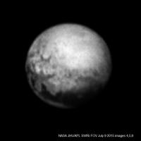
3 stacked images, colorized using MVIC data.
I see cracks everywhere.
Attached thumbnail(s)
-------------------- |
|
|
|
|
|
|
Jul 11 2015, 03:57 PM
Post
#545
|
||
 Senior Member Group: Members Posts: 4247 Joined: 17-January 05 Member No.: 152 |
Here's the average of the two earlier frames, lor_0298787064 and lor_0298787094, animated together with the later frame, lor_0298787344 (all 4x Lanczos oversampled, but no other processing):
So the two frames in the animation are separated by about 4 1/2 minutes. This animation shows that it's now quite easy to see the disc get larger in that amount of time, together with a bit of rotation. We really are hurtling towards encounter! I don't see any sign of any other real changes in that interval (eg, moving clouds); all the other changes appear to be consistent with differences in noise between the frames. |
|
|
|
|
|
|
Jul 11 2015, 04:04 PM
Post
#546
|
|
|
Member Group: Members Posts: 153 Joined: 20-December 14 From: Eastbourne, UK Member No.: 7372 |
QUOTE (machi @ Jul 11 2015, 04:08 PM) I see cracks everywhere. Charon looks almost like a football made up of huge slabs of crust. Looking at ZLD's images they might be huge scarps and cliffs, rather than just cracks. Charon may be the one with, or once with, a liquid ocean, its certainly looking like a chaotic little world. The colour Pluto image shows large cluster of bright white areas near the pole. This is the area where gases are sublimating and escaping the surface, its pointed directly at the sun and the escaping gas has either brought fresh ices to the surface or the movement of gas displaces the darker dust and organics, probably both. The concentric circles of changing colour moving out from this bright basin shows a deposition nature, where the heaviest, complex organics are deposited first, followed by the orange and red colours of the Thollins and then the darker colours of the lightest dust and undisturbed, comic ray blasted, charred organics in the equatorial region. The spectroscopic data from the centre to the edge of the basin will be very interesting. This summer long sublimation has carved out a huge basin throughout the temperate latitudes, interrupted only by the shadowy hand of Charon. One would think this is mirrored in the Southern Hemisphere. The polar attitudes are probably higher than this basin and appear to be more solid with signs of cratering. There seems to be a couple of impact craters near the equator where the equatorial mountain bands meet the heart plateau, they are in the lea of the Northern mountains and so have not been resurfaced. They also lie close to NH's close approach track so hopefully we might get some higher resolution images of that junction between the mountains and plateau. |
|
|
|
|
Jul 11 2015, 04:10 PM
Post
#547
|
||
|
Junior Member Group: Members Posts: 71 Joined: 3-February 11 Member No.: 5800 |
I lowered the brightness overall in order to bring out any contrast variations in the polar region.
The face that NH will see up close, with the "heart", has the interesting intersection of 3 different looking (terrains?). Obviously not the same, but something similar worked out well for science with Curiosity at Mars. And I bet the Charon shine imaging will work out well for other longitudes. |
|
|
|
|
|
|
Jul 11 2015, 04:12 PM
Post
#548
|
|
 Senior Member Group: Members Posts: 1632 Joined: 5-March 05 From: Boulder, CO Member No.: 184 |
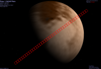
QUOTE (tolis @ Jul 11 2015, 12:28 PM) perhaps our resident experts can advise on where the sub-charon point on pluto (and the sub-pluto point on charon) would lie on these images. As some related perspective we can recall that the sub-points of each object on the other are defined to be zero longitude (and on their respective equators). The NH website image releases show drawings of this prime meridian on their little grid insets. The sub-point of Charon on Pluto is thus at zero longitude, about in the middle of the 4 dark spots region (as mentioned west of the whale tail). This is also where we'd expect the best Charon shine on Pluto. The prime meridian is shown for the July 9 Pluto image on this release. Usually the cylindrical projection maps we've seen are positioned with zero longitude on the edges (or in the middle) of the map, hopefully they are captioned or labeled as such like this one. -------------------- Steve [ my home page and planetary maps page ]
|
|
|
|
|
Jul 11 2015, 04:16 PM
Post
#549
|
|
|
Member Group: Members Posts: 796 Joined: 27-February 08 From: Heart of Europe Member No.: 4057 |
I did few tables with planned remote sensing observations of New Horizons in the Pluto-Charon system.
They cover distances ~+/- 1 million km and they are based on data from NASA's Eyes application, New Horizons Observation Playbook and other sources. I think that it can be useful. LORRI/Ralph represents simultaneous observations by both instruments. Number behind "LORRI" is number of individual frames. Unfortunately it's published only for few observations. Here is table for the LORRI imager. ADMIN Note: Added file to the FAQs -------------------- |
|
|
|
|
Jul 11 2015, 04:57 PM
Post
#550
|
|||
 Senior Member Group: Moderator Posts: 3233 Joined: 11-February 04 From: Tucson, AZ Member No.: 23 |
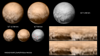
I've put together Celestia previews of the frames we can expect to get from New Horizons during this encounter period (as well as the Pluto C/A LORRI strip, though no images from that will come back for a few months) using Bjorn's latest Pluto and Charon maps. (also I had to exclude the Charon mosaic because the mosaic designs I have and the phase angle of Charon at the time didn't seem to match up, I'll figure out what happened later today...)
http://imgur.com/a/SWz2L I've attached to this post updated version of the two Pluto mosaic designs I posted a few days ago, now with updated maps.
-------------------- &@^^!% Jim! I'm a geologist, not a physicist!
The Gish Bar Times - A Blog all about Jupiter's Moon Io |
||
|
|
|
||
|
Jul 11 2015, 05:04 PM
Post
#551
|
||
|
Member Group: Members Posts: 153 Joined: 20-December 14 From: Eastbourne, UK Member No.: 7372 |
QUOTE (FOV @ Jul 11 2015, 05:10 PM) I lowered the brightness overall in order to bring out any contrast variations in the polar region.
Looking at that image the effect of Charon can be seen nicely. The tidal bulge created on the surface and in the tenuous atmosphere creates two areas of raised mountainous regions extending into temperate latitudes on opposite sides of the planet. The edge of the heart shaped plateau can just be seen at around 2 O'Clock creeping up towards the North Pole, the rugged and mountainous terrain about 8 O'clock also creeps up to about 10 O'Clock, gravity sucking the surface and the tenuous atmosphere with its cargo of gas, organics and dust into higher latitudes. Of course once the sublimated gases gain altitude they start to condense and freeze, increasing the size of the mountain, which the summer sun can only partially offset. There are hints of craters in the polar region, but in the light of Ceres, Titan and 67P sinkholes can also be considered a possibility. |
|
|
|
|
|
|
Jul 11 2015, 05:18 PM
Post
#552
|
|
 Senior Member Group: Members Posts: 1887 Joined: 20-November 04 From: Iowa Member No.: 110 |
QUOTE (Mercure @ Jul 11 2015, 02:02 AM) Given the dearth of objects to crash into in the outer Solar System and the surface-altering properties of a binary system, we should perhaps not be too surprised if Pluto-Charon turn out to have very few scars from craters. If the Nice model is accurate there would have been more objects around to collide with it before the instability that rearranged the solar system. With Pluto's atmosphere and ~4 billion years since then these craters would greatly eroded, perhaps some survive on Charon. I hope the KBO New Horizon encounters in 2019 is one of the cold classicals, if they formed at there current locations the may have spent most of their existence in a low collision environment. |
|
|
|
|
Jul 11 2015, 05:18 PM
Post
#553
|
|
|
Senior Member Group: Members Posts: 1018 Joined: 29-November 05 From: Seattle, WA, USA Member No.: 590 |
What percentage of Pluto and Charon will not be imaged at any resolution? (Other than by reflected light.) I had thought Pluto was still fairly close to its equinox, but the recently-released map makes it look as though a great deal of the southern hemisphere is in darkness. I'm hoping that's just an artifact of the approach trajectory.
Is there a color-coded map somewhere that actually shows what sort of resolution to expect for different parts of the two spheres? I seem to remember Mercury Messenger had such a map, which was color-coded based on the best expected resolution for each part of the surface. Does anything like that exist for New Horizons? |
|
|
|
|
Jul 11 2015, 05:19 PM
Post
#554
|
||
|
Junior Member Group: Members Posts: 65 Joined: 19-November 14 From: Milan, Italy Member No.: 7340 |
QUOTE (Habukaz @ Jul 11 2015, 04:49 PM) Nah, the donut appears to have dissolved; figuratively speaking. I made this earlier today, and it should roughly be correct: I made a similar map and I can't see the donut feature (landmark n.1 on my map) either. However, there appears to be a kinda-circular feature (n. 6) unseen in previous images. Obviously everything you see is still very approximate and tentative.
|
|
|
|
|
|
|
Jul 11 2015, 05:23 PM
Post
#555
|
||
|
Junior Member Group: Members Posts: 71 Joined: 3-February 11 Member No.: 5800 |
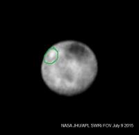
Yes, Charon is getting bigger and bigger with each LORRI release:) Used last 2 anyway, even if this is now problematic for stacking. The circled region remained bright even when really damping down on brightness and contrast that dimmed other bright regions. I don't know if that means anything. I am still hoping that the dark pole is a sign of cryo activity. My spec.
|
|
|
|
|
|
|

|
Lo-Fi Version | Time is now: 5th May 2024 - 08:29 PM |
|
RULES AND GUIDELINES Please read the Forum Rules and Guidelines before posting. IMAGE COPYRIGHT |
OPINIONS AND MODERATION Opinions expressed on UnmannedSpaceflight.com are those of the individual posters and do not necessarily reflect the opinions of UnmannedSpaceflight.com or The Planetary Society. The all-volunteer UnmannedSpaceflight.com moderation team is wholly independent of The Planetary Society. The Planetary Society has no influence over decisions made by the UnmannedSpaceflight.com moderators. |
SUPPORT THE FORUM Unmannedspaceflight.com is funded by the Planetary Society. Please consider supporting our work and many other projects by donating to the Society or becoming a member. |
|