Printable Version of Topic
Click here to view this topic in its original format
Unmanned Spaceflight.com _ Phoenix _ Holy Cow!
Posted by: manishm1020 Oct 13 2008, 10:52 PM
Does anyone from the engineering side or the science team know the dimensions of the exposed ice under the lander? Particularly, the radius from the outermost ice periphery to the spacecraft centerline? Also, is there a DEM (digital elevation map) of the exposed ice sheet? I think this is the largest altered site due to plume effects seen in space exploration. Quite exciting! Any information that may be known would be great! Thanks!
PS. My preliminary calculations are: radius = ~ 60-75 cm and there appears to be three exposed regions.
Posted by: manishm1020 Oct 21 2008, 02:04 PM
Does anyone have an estimate of how much ice was exposed after landing? I have gotten numbers from 1 m to 0.5 m in radius? Thanks so much!
Posted by: PDP8E Jun 19 2010, 08:13 PM
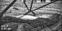
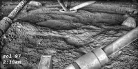
I have been exploring the Phoenix Analyst Notebook site this weekend and worked up some Holy Cow shots.
BTW: Is is me or is The Phoenix Notebook site kind of clunky to use?
These are Holy Cow images (processed) during the day and after midnight
|
|
I tried to merge them with a stacker - the results were NOT pretty!
Cheers
Posted by: mgrodzki Jun 24 2010, 10:14 PM
No higher res? That night shot is pretty spiffy.
Posted by: Hungry4info Jun 24 2010, 10:25 PM
Hang on, with being above the arctic circle, surely the "night shot" wasn't done at a literal night time.... ?
Posted by: djellison Jun 25 2010, 12:03 AM
The RAC has LED's to illuminate the contents of the scoop remember. But I think it was just dusk-like, not actual pitch black.
Posted by: Deimos Jun 25 2010, 02:14 AM
The LED utility beyond the scoop is quite limited. The LEDs would not have given such an image. The Sun was 3-4 deg up, to the NNE. It was imaged by SSI around then, but it probably didn't even shine on the surface ("hill" in that direction), but the light was mostly diffuse anyway.
Powered by Invision Power Board (http://www.invisionboard.com)
© Invision Power Services (http://www.invisionpower.com)