2007-09-10 Iapetus (rev 49): Pre-flyby discussion, Closest approach of this odd moon |

 Unmanned Spaceflight.com > Outer Solar System > Saturn > Cassini Huygens > Cassini's ongoing mission and raw images
  |
2007-09-10 Iapetus (rev 49): Pre-flyby discussion, Closest approach of this odd moon |
 Aug 18 2007, 05:39 PM Aug 18 2007, 05:39 PM
Post
#76
|
||
 Senior Member  Group: Members Posts: 1627 Joined: 5-March 05 From: Boulder, CO Member No.: 184 |
Fascinating set of Aug 2004 images Rob that I see here for the first time. This will be worth analyzing further. Hopefully (in spite of some travel plans) I'll have the time to do this before mid September! Quite the central peak showing up on the terminator. I could try and add some of the images to my map to help the intepretation. Would anyone happen to have any images (or at least dates), say from the PDS? The Cassini raw images page appears to be overexposed and perhaps is incomplete.
What I've been showing as the eastern member of the pair of basin rims may have too low of a contrast with the higher solar elevation angle (and greater limb foreshortening) to show up at the ~50 km/pix resolution of the August 2004 images. Running this in Celestia is helpful - I think I can identify the "dark triangle" feature as a reference. Below is a possible fit to the second image in the row from Tilmann's abstract. In this scenario the central peak near the terminator in Tilmann's image isn't showing up in the July 2007 imagery as the solar elevation also was higher there.
(post edited 1832 UTC Aug 18) -------------------- Steve [ my home page and planetary maps page ]
|
|
 |
 
|
|
|
Aug 18 2007, 06:45 PM
Post
#77
|
|||
 Senior Member Group: Members Posts: 3648 Joined: 1-October 05 From: Croatia Member No.: 523 |
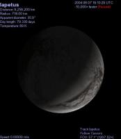
QUOTE (scalbers @ Aug 18 2007, 06:39 PM)  Would anyone happen to have any images (or at least dates), say from the PDS? The Cassini raw images page appears to be overexposed and perhaps is incomplete. The images you want are OPNAVs so the target is listed as SKY, not Iapetus. There are only 3 images that target Iapetus specifically, with varying exposure - here's one with normal exposure and to its right a sharpened view to remove PSF blur:
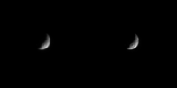
And here are the 12 opnavs you want taken in August 2004, the bottom row is sharpened:
Both composites are 16-bit PNGs, not that it matters much. No resizing done. And a quick, 4x magnified animation of all 13 frames: 
-------------------- |
||
|
|
|
||
|
Aug 18 2007, 06:55 PM
Post
#78
|
||
 Member Group: Members Posts: 288 Joined: 28-September 05 From: Orion arm Member No.: 516 |
Damn, now I remember reading Tilmann Denk's abstract in 2005 and especially those far distant image series showing the large Roncevaux Terra basin...

Doesn't really look like double impact structure any more - but the extent of the central peak is enormous! Steve, the "dark triangle" is certainly visible in the two pics on the left. Bye. |
|
|
|
|
|
|
Aug 18 2007, 07:19 PM
Post
#79
|
|
|
Senior Member Group: Members Posts: 1627 Joined: 5-March 05 From: Boulder, CO Member No.: 184 |
Ugordon's 13 frame animation is pretty cool. I think the first frame or two have better lighting conditions and actually display a bit of shadowing that betrays the presence of a second eastern basin rim

-------------------- Steve [ my home page and planetary maps page ]
|
|
|
|
|
Aug 18 2007, 10:34 PM
Post
#80
|
|
|
Solar System Cartographer Group: Members Posts: 10150 Joined: 5-April 05 From: Canada Member No.: 227 |
I must confess that the animation seems to me to show just the one rim plus the central mound, not a double rim. I still hold out for one rim. But time will tell.
Phil -------------------- ... because the Solar System ain't gonna map itself.
Also to be found posting similar content on https://mastodon.social/@PhilStooke NOTE: everything created by me which I post on UMSF is considered to be in the public domain (NOT CC, public domain) |
|
|
|
|
Aug 18 2007, 10:39 PM
Post
#81
|
|
|
Senior Member Group: Members Posts: 1627 Joined: 5-March 05 From: Boulder, CO Member No.: 184 |
Yes, the nice thing about this question is that it is likely to be definitively answered in a few weeks. I wonder though what that shading east of the main rim is that shows up in the first frame of the animation? It quickly disappears as the lighting changes, just as the main eastern rim shadow subsequently disappears as its lighting changes.
I would predict that if I project the first frame as an overlay onto my existing map we'd see these two apparent rims match on top of the ones I presently am mapping. Or I could be patient and wait 
-------------------- Steve [ my home page and planetary maps page ]
|
|
|
|
|
Aug 18 2007, 11:08 PM
Post
#82
|
|
|
Senior Member Group: Members Posts: 3648 Joined: 1-October 05 From: Croatia Member No.: 523 |
I don't know, I'm inclined to say one rim only judging by these views alone. Bicubic filtering can play tricks as well, here's an old style enlargement:
 The data is too low-res to make a good case, but I would expect a different lighting pattern there in case of 2 rims. T-22 days and counting... -------------------- |
|
|
|
|
Aug 21 2007, 10:35 PM
Post
#83
|
|
|
Senior Member Group: Members Posts: 1627 Joined: 5-March 05 From: Boulder, CO Member No.: 184 |
I guess I found a little bit of time after all. I added a quick remap of the first of ugordon's frames into the blinking GIF I posted in another Iapetus thread. This illustrates how I see a number of interesting features lining up in the various combinations of images:
http://laps.noaa.gov/albers/sos/saturn/iap..._2x_070821a.gif That's the latest, -------------------- Steve [ my home page and planetary maps page ]
|
|
|
|
|
Aug 22 2007, 06:23 PM
Post
#84
|
|
|
Member Group: Members Posts: 234 Joined: 8-May 05 Member No.: 381 |
Tom Tamlyn asked why the upcoming Iapetus flyby is the only use of the radar instrument on an icy satellite. This is a question I'm interested in as well. This is an educated guess based on what little I know of Cassini. First of all, SAR uses an enormous amount of Cassini's memory to store its data. I think most of the Titan flybys that imaged in SAR had few other instrument observations, partly because of data storage requirements and partly because Cassini has no scan platform so the entire spacecraft has to change its orientation to use different instruments.
The amazing thing is probably that Cassini WILL use its radar at Iapetus in addition to most of its other instruments. I suspect it will be a very small snapshot, not primarily for imaging but to provide data on the physical characteristics of the surface material. If radar at Iapetus turns up something unexpected, then perhaps we will see it used for other future icy satellite flybys (keeping in mind it can only be used at close range, I think less than 1000 km). It seems to me that it would be interesting to use it on a close flyby of Enceladus's tiger stripes during the extended mission to further characterize the surface at plume eruption sites. But all this is just bait to bring in someone who really understands the situation to explain it to us.
|
|
|
|
|
Aug 22 2007, 07:13 PM
Post
#85
|
|
 Member Group: Members Posts: 114 Joined: 6-November 05 From: So. Maryland, USA Member No.: 544 |
QUOTE (monitorlizard @ Aug 22 2007, 01:23 PM) But all this is just bait to bring in someone who really understands the situation to explain it to us. That wouldn't be me. I could imagine using SAR to better understand the morphology of the equatorial ridge and white mountains, though. |
|
|
|
|
Aug 22 2007, 07:16 PM
Post
#86
|
|
 Senior Member Group: Members Posts: 2530 Joined: 20-April 05 Member No.: 321 |
QUOTE (monitorlizard @ Aug 22 2007, 11:23 AM) Tom Tamlyn asked why the upcoming Iapetus flyby is the only use of the radar instrument on an icy satellite. This is a question I'm interested in as well. This is an educated guess based on what little I know of Cassini. I think these are all clearly factors: 1) RADAR eats up a lot of observing time and even attitude-control propellant. As well as, monitorlizard points out, onboard data storage. 2) RADAR has a much worse spatial resolution than ISS. RADAR returns 300m/pix imagery of Titan at 950km altitude. ISS, in contrast, returned about the same resolution of Iapetus from 55,000 km away. If you don't have the veils of Titan to contend with, the price-performance curve of these two instruments is very lopsided. 3) Nobody's expecting big surprises in the regoliths of the icy satellites. Not at 300m/pix resolution, anyway, if you can get, instead, 10m/pix visible resolution. While I'm sure that if a full RADAR dataset of the icy satellites existed, they'd want to look at it instead of throw it away, the cost of using RADAR is very slim compared to the expected gain. Even Titan is only going to receive a few dozen RADAR scans -- there's no way they'd want to burn half a dozen more sampling each of the icy satellites, losing the ISS imagery that could have been had. I might opine that a single RADAR stripe on *one* icy satellite might be a worthwhile peek to see if there are any surprises in the impact-regolith that dominates their surfaces. Again, it's a cost-value decision, I'm sure. Maybe in the extended mission, but I think if they did want to try it, they'd want to examine Enceladus's active features rather than bland impact-cratered highlands. Final note: radar from Earth can be used on these satellites to determine the gross reflectivity in radar bands. So even that goal would be a waste of Cassini's resources when it can be done at our leisure from a billion miles away. The only use of RADAR would be to map a place much better than from Earth but much worse than ISS. |
|
|
|
|
Aug 22 2007, 08:07 PM
Post
#87
|
|
|
Member Group: Members Posts: 220 Joined: 13-October 05 Member No.: 528 |
I seem to remember reading somewhere that Radar can give you information about surface roughness. In other words, average size of the rocks, pebbles, or snowballs, as the case may be.
Since there is a major debate as to what the difference is between the light and dark regolith on Iapetus, perhaps radar can offer one more (and unique) piece of data to help. Another factor might be the relatively slow encounter speed. When Cassini is close to the lowest (and fastest) part of it's orbit, it can take only a relatively few measurements of the inner moons furing a flyby. But it will be at it's apehelion when encountering Iapetus, so it will have much more time to cycle between the vastly different pointing requirements of the ISS vs. RADAR. |
|
|
|
|
Aug 22 2007, 08:42 PM
Post
#88
|
|
|
Senior Member Group: Members Posts: 2530 Joined: 20-April 05 Member No.: 321 |
QUOTE (Mariner9 @ Aug 22 2007, 01:07 PM) I seem to remember reading somewhere that Radar can give you information about surface roughness. In other words, average size of the rocks, pebbles, or snowballs, as the case may be. Since there is a major debate as to what the difference is between the light and dark regolith on Iapetus, perhaps radar can offer one more (and unique) piece of data to help. This should be possible to do from Earth. The resolution would be terrible (pretty much one "pixel" for the whole moon), but since the light and dark surfaces are pretty much two different hemispheres, it should be possible to do some investigation from the good ol' Earth. In fact, Earth-based radar has been used on Iapetus. Radar Detection of Iapetus Gregory J. Black, Donald B. Campbell, Lynn M. Carter, and Steven J. Ostro Science 23 April 2004: Vol. 304. no. 5670, p. 553 Cassini RADAR has also been used for radiometry (not SAR) on many of the icy satellites. Cassini RADAR observations of Enceladus, Tethys, Dione, Rhea, Iapetus, Hyperion, and Phoebe Ostro, et al Icarus, Volume 183, Issue 2, p. 479-490. "Iapetus' 2.2-cm radar albedo is dramatically higher on the optically bright trailing side than the optically dark leading side, whereas 13-cm results reported by Black et al. [Black, G.J., Campbell, D.B., Carter, L.M., Ostro, S.J., 2004. Science 304, 553] show hardly any hemispheric asymmetry and give a mean radar reflectivity several times lower than the reflectivity measured at 2.2 cm. These Iapetus results are understandable if ammonia is much less abundant on both sides within the upper one to several decimeters than at greater depths, and if the leading side's optically dark contaminant is present to depths of at least one to several decimeters." So the gist is: similar at 13cm, much darker (= smoother?) on the dark side at 2.2 cm. This could tell us about the surface roughness at different scales, or about the composition. Anyway, SAR mode would tell us something different than radiometry, and it's that kind of observation that is so expensive in terms of operations, etc. |
|
|
|
|
Aug 22 2007, 10:06 PM
Post
#89
|
|
|
Member Group: Members Posts: 234 Joined: 8-May 05 Member No.: 381 |
Radar can tell you if a surface is rough or smooth at a scale equal to the wavelength of the radar. That would provide general information (but not image resolution) better than the ten meter ISS resolution that Cassini will achieve at Iapetus. I'm a little out of my depth here, but I believe I've stated it correctly.
|
|
|
|
|
Aug 22 2007, 10:30 PM
Post
#90
|
|
|
Senior Member Group: Members Posts: 2530 Joined: 20-April 05 Member No.: 321 |
QUOTE (monitorlizard @ Aug 22 2007, 03:06 PM) Radar can tell you if a surface is rough or smooth at a scale equal to the wavelength of the radar. That would provide general information (but not image resolution) better than the ten meter ISS resolution that Cassini will achieve at Iapetus. I'm a little out of my depth here, but I believe I've stated it correctly. That's true, but you can do the same thing from the Earth. You would get data that averages over a large footprint on Iapetus, but that would enable a comparison between the two kinds of surface. Indeed, the citation I provided to an article in Science reports on just such a comparison. Using Cassini to do this can be done from farther away, and needn't be done at the precious encounter. SAR must be done up close -- radiometry can be (and already has been) done from farther away. |
|
|
|
|

|
Lo-Fi Version | Time is now: 24th April 2024 - 11:20 AM |
|
RULES AND GUIDELINES Please read the Forum Rules and Guidelines before posting. IMAGE COPYRIGHT |
OPINIONS AND MODERATION Opinions expressed on UnmannedSpaceflight.com are those of the individual posters and do not necessarily reflect the opinions of UnmannedSpaceflight.com or The Planetary Society. The all-volunteer UnmannedSpaceflight.com moderation team is wholly independent of The Planetary Society. The Planetary Society has no influence over decisions made by the UnmannedSpaceflight.com moderators. |
SUPPORT THE FORUM Unmannedspaceflight.com is funded by the Planetary Society. Please consider supporting our work and many other projects by donating to the Society or becoming a member. |
|