Juno perijove 8, September 1, 2017 |

  |
Juno perijove 8, September 1, 2017 |
 Sep 24 2017, 12:00 AM Sep 24 2017, 12:00 AM
Post
#61
|
|
 Senior Member  Group: Members Posts: 1628 Joined: 5-March 05 From: Boulder, CO Member No.: 184 |
Nice to see these realistically processed views. One fine point is that with such high resolution we might be able to resolve a region along the limb where a high clear portion of the atmosphere would produce a thin blue layer due to Rayleigh scattering. Is the limb fully shown in these images?
-------------------- Steve [ my home page and planetary maps page ]
|
 |
 
|
|
Oct 1 2017, 12:43 PM
Post
#62
|
|
 IMG to PNG GOD Group: Moderator Posts: 2250 Joined: 19-February 04 From: Near fire and ice Member No.: 38 |
The limb is not fully shown. The images are processed by creating a simple cylindrical map and then using the map to render an image. This 'truncates' the limb near the 1 bar level. That said, I suspect the resolution at the limb isn't higher in the JunoCam images than in many of the Voyager images since the resolution at the limb is much lower than at the nadir (I haven't computed the exact resolution at the limb though).
I have experimented a bit with creating JunoCam color composites showing the limb but the results aren't very interesting. The best processed Voyager image I know of showing the limb is this one from Voyager 1 and there is also a Voyager 2 mosaic. These are also probably the highest resolution color images showing blue sky at the limb that can be processed from the Voyager 1 and Voyager 2 data. |
|
|
|
|
Oct 6 2017, 07:51 PM
Post
#63
|
|||||||
|
IMG to PNG GOD Group: Moderator Posts: 2250 Joined: 19-February 04 From: Near fire and ice Member No.: 38 |
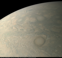
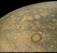
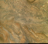
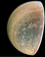
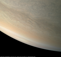
Image PJ8_110, approximately true color/contrast:
And with enhanced color and contrast. The effects of the solar illumination have been removed:
Lots of cloud shadows are visible, especially in the 'central' image (the one where Jupiter's limb isn't visible). Possible vertical relief can also be seen at various locations. And the relevant metadata: IMAGE_TIME = 2017-09-01T21:37:50.343 MISSION_PHASE_NAME = PERIJOVE 8 PRODUCT_ID = JNCE_2017244_08C00110_V01 SPACECRAFT_ALTITUDE = 9838.0 SPACECRAFT_NAME = JUNO SUB_SPACECRAFT_LATITUDE = 41.77 SUB_SPACECRAFT_LONGITUDE = 310.6919 TITLE = POI: AB Territory Resolution at nadir: ~6.6 km/pixel |
||||||
|
|
|
||||||
|
Oct 7 2017, 08:28 PM
Post
#64
|
||
|
IMG to PNG GOD Group: Moderator Posts: 2250 Joined: 19-February 04 From: Near fire and ice Member No.: 38 |
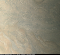
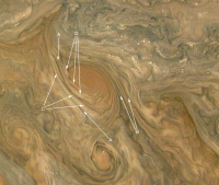
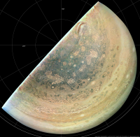
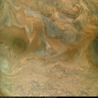
The central image in the above post has some of the best examples of direct imaging of (probable) cloud elevation differences that I have seen in images of Jupiter. Here is an enlarged crop from the image with some annotations:
The sun illuminates the clouds from the west (left) in this image. Keeping this in mind it's looking very much like we are seeing 'topography' at various locations, in particular around the vortex left of center: A: Clearly defined 'valleys'. B: More subtle 'valleys' than in A. C: Elevated and elongated high altitude 'walls' of clouds that are apparently roughly parallel to the wind direction around the vortex. D: Elevated clouds that have a more irregular shape than the clouds in C. There are also some some subtle indications that narrower and subtle 'valleys' and 'ridges' may spiral into the vortex toward its center. It is possible that these features are due to clouds of different color/brightness and not due to altitude differences. However, looking at the image, altitude differences look to me like the obvious (and more likely) explanation. |
|
|
|
|
|
|
Oct 16 2017, 09:52 PM
Post
#65
|
||||
|
IMG to PNG GOD Group: Moderator Posts: 2250 Joined: 19-February 04 From: Near fire and ice Member No.: 38 |
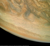
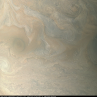
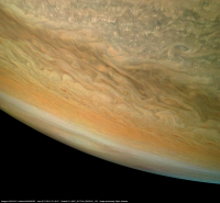
Image PJ8_124, true color/contrast version and an enhanced version:
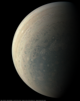
In the enhanced version the effects of global illumination have been removed. This reveals various details in the dimly lit areas near the terminator and near the south pole. And an orthographic view showing the south pole:
A latitude/longitude grid is included. This reveals the location of Jupiter's south pole. It's remarkable how different Jupiter's polar areas are from Saturn's. They look much more irregular and chaotic, the belt/zone structure breaks down and in particular there is no vortex centered on Jupiter's pole as in Saturn's case. Another interesting feature is the relatively narrow, curved band of haze (?) not far from the pole. A subset of the metadata associated with the original data: IMAGE_TIME = 2017-09-01T22:34:02.788 MISSION_PHASE_NAME = PERIJOVE 8 PRODUCT_ID = JNCE_2017244_08C00124_V01 SPACECRAFT_ALTITUDE = 60546.9 km SPACECRAFT_NAME = JUNO SUB_SPACECRAFT_LATITUDE = -71.5392 SUB_SPACECRAFT_LONGITUDE = 355.0833 TITLE = POI: South Polar region Resolution at nadir: ~40 km/pixel |
|||
|
|
|
|||
|
Oct 18 2017, 06:20 PM
Post
#66
|
|
|
Senior Member Group: Members Posts: 2346 Joined: 7-December 12 Member No.: 6780 |
John Rogers (BAA) posted his detailed and interesting PJ08 report.
Note, that global maps will be increasingly difficult to obtain for the next perijoves, and likely impossible at some point. |
|
|
|
|
Oct 19 2017, 03:15 AM
Post
#67
|
|
 Administrator Group: Admin Posts: 5172 Joined: 4-August 05 From: Pasadena, CA, USA, Earth Member No.: 454 |
Jupiter's south pole is a "vortex crystal" with a stable pentagonal arrangement of cyclones: https://twitter.com/jtuttlekeane/status/920409321246199814
Work by Fachreddin Tabataba-Vakili. You can see part of the pentagon clearly in Bjorn's polar projection. -------------------- My website - My Patreon - @elakdawalla on Twitter - Please support unmannedspaceflight.com by donating here.
|
|
|
|
|
Oct 19 2017, 09:43 AM
Post
#68
|
|
|
Senior Member Group: Members Posts: 2346 Joined: 7-December 12 Member No.: 6780 |
I doubt, that these things are cleared for public release as of yet.
|
|
|
|
|
Oct 19 2017, 02:44 PM
Post
#69
|
|
|
Senior Member Group: Members Posts: 2511 Joined: 13-September 05 Member No.: 497 |
QUOTE (Gerald @ Oct 19 2017, 01:43 AM)  I doubt, that these things are cleared for public release as of yet. If you don't want to release something, then don't stand up at a public conference and present it. There's a DPS abstract online for this, although it has some coy language: "These observations reveal a turbulent environment with an unexpected structure of cyclonic polar vortices." -------------------- Disclaimer: This post is based on public information only. Any opinions are my own.
|
|
|
|
|
Oct 19 2017, 03:57 PM
Post
#70
|
|
|
Senior Member Group: Members Posts: 2346 Joined: 7-December 12 Member No.: 6780 |
After some more investigation, I think, that we are on the safe side of the grey area, as long as we don't comment publicly on the contents of the tweets.
|
|
|
|
|
Oct 19 2017, 04:04 PM
Post
#71
|
|
|
Senior Member Group: Members Posts: 2511 Joined: 13-September 05 Member No.: 497 |
QUOTE (Gerald @ Oct 19 2017, 07:57 AM) After some more investigation, I think, that we are on the safe side of the grey area... You mean "you are". My name's not on the abstract. 
-------------------- Disclaimer: This post is based on public information only. Any opinions are my own.
|
|
|
|
|
Oct 19 2017, 04:16 PM
Post
#72
|
|
|
Senior Member Group: Members Posts: 2346 Joined: 7-December 12 Member No.: 6780 |
You are in Candy's team. Without your camera neither Candy's nor my name would be on the abstract, if it could have been written at all.
|
|
|
|
|
Oct 23 2017, 11:18 PM
Post
#73
|
|||||||
|
IMG to PNG GOD Group: Moderator Posts: 2250 Joined: 19-February 04 From: Near fire and ice Member No.: 38 |
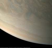
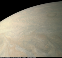
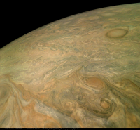
Yet another collection of images, this is from PJ8_111 (approximately true color/contrast):
And a version with enhanced contrast and color. The effects of global illumination have been removed:
The subspacecraft latitude is ~36 degrees north. Areas around this latitude are particularly photogenic in the JunoCam imagery with lots of cloud shadows, small vortices, various colors, vertical relief etc. For example, there are also these images from PJ6 where the subpscecraft latitude is similar (there are several more versions processed from this particular data set in the PJ6 thread). Finally a subset of the metadata: IMAGE_TIME = 2017-09-01T21:40:20.749 MISSION_PHASE_NAME = PERIJOVE 8 PRODUCT_ID = JNCE_2017244_08C00111_V01 SPACECRAFT_ALTITUDE = 7545.3 km SPACECRAFT_NAME = JUNO SUB_SPACECRAFT_LATITUDE = 35.6148 SUB_SPACECRAFT_LONGITUDE = 312.671 TITLE = POI: Turbulent sector of the NNTB Resolution at nadir: ~5.1 km/pixel |
||||||
|
|
|
||||||
|
Nov 5 2017, 09:15 PM
Post
#74
|
|
|
Member Group: Members Posts: 406 Joined: 18-September 17 Member No.: 8250 |
My PJ08 approach movie. PJ08 Approach Movie Has a number of shadows (or maybe sensor artifacts, I haven't investigated yet).
PJ08 departure movie. PJ08 Departure Movie Coloration along edges due to imperfections in my camera model. |
|
|
|
|
Dec 18 2017, 05:15 AM
Post
#75
|
|
|
Member Group: Members Posts: 923 Joined: 10-November 15 Member No.: 7837 |
PJ08_108 update [G.Eichstadt]
Detail  -------------------- |
|
|
|
|

|
Lo-Fi Version | Time is now: 24th April 2024 - 11:53 PM |
|
RULES AND GUIDELINES Please read the Forum Rules and Guidelines before posting. IMAGE COPYRIGHT |
OPINIONS AND MODERATION Opinions expressed on UnmannedSpaceflight.com are those of the individual posters and do not necessarily reflect the opinions of UnmannedSpaceflight.com or The Planetary Society. The all-volunteer UnmannedSpaceflight.com moderation team is wholly independent of The Planetary Society. The Planetary Society has no influence over decisions made by the UnmannedSpaceflight.com moderators. |
SUPPORT THE FORUM Unmannedspaceflight.com is funded by the Planetary Society. Please consider supporting our work and many other projects by donating to the Society or becoming a member. |
|