Exploring Mt Sharp - The Dunes - Part 1: Bagnold Dunes, Site 51-53, Sol 1172-1273, November 24, 2015-March 6, 2016 |

  |
Exploring Mt Sharp - The Dunes - Part 1: Bagnold Dunes, Site 51-53, Sol 1172-1273, November 24, 2015-March 6, 2016 |
 Feb 25 2016, 04:52 PM Feb 25 2016, 04:52 PM
Post
#301
|
||
|
Senior Member  Group: Members Posts: 1074 Joined: 21-September 07 From: Québec, Canada Member No.: 3908 |
Sol 1262 Lmastcam panorama:
|
|
 |
 
|
|
|
Feb 25 2016, 08:01 PM
Post
#302
|
||
|
Senior Member Group: Members Posts: 2820 Joined: 22-April 05 From: Ridderkerk, Netherlands Member No.: 353 |
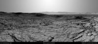
The Navcam L view on Sol 1262.
Jan van Driel
|
|
|
|
|
|
|
Feb 25 2016, 09:05 PM
Post
#303
|
||
|
Solar System Cartographer Group: Members Posts: 10153 Joined: 5-April 05 From: Canada Member No.: 227 |
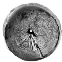
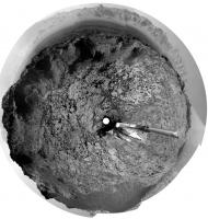
Very nice! Here it is in a circular form.
Phil (PS I really like those RMI mosaics of the Gale rim)
-------------------- ... because the Solar System ain't gonna map itself.
Also to be found posting similar content on https://mastodon.social/@PhilStooke Maps for download (free PD: https://upload.wikimedia.org/wikipedia/comm...Cartography.pdf NOTE: everything created by me which I post on UMSF is considered to be in the public domain (NOT CC, public domain) |
|
|
|
|
|
|
Feb 26 2016, 03:16 AM
Post
#304
|
|
|
Member Group: Members Posts: 306 Joined: 4-October 14 Member No.: 7273 |
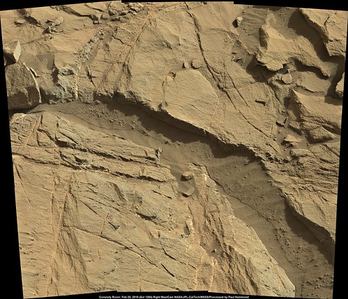
Here's a couple of ChemCam RMI mosaics of the Peace Vallis area with a MastCam M-34 context shot. The ChemCam mosaics are from Sols 1252 and 1263 data, the context image is from Sol 1163 (tt's been a while since MastCam has made a mosaic of the crater rim!) I don't think this is entirely complete, since there are a couple of RMI mosaics from Sol 1257 that appear to be somewhere in the Peace Vallis fan. However, the MastCam image is heavily artifacted, which isn't helping...
 Peace Vallis by Justin Cowart, on Flickr I did manual stitching and made heavy use of the dodge and burn tools to assemble the RMI mosaics. They're really spectacular, but working with them is a lot like massaging vidicon images from the early Space Age! |
|
|
|
|
Feb 26 2016, 01:28 PM
Post
#305
|
|
|
Member Group: Members Posts: 923 Joined: 10-November 15 Member No.: 7837 |
Fantastic work there Justin...maybe we can petition to get the Rover to image the entire crater wall this way. /half joking
-------------------- |
|
|
|
|
Feb 27 2016, 01:58 AM
Post
#306
|
|
|
Member Group: Members Posts: 923 Joined: 10-November 15 Member No.: 7837 |
-------------------- |
|
|
|
|
Feb 27 2016, 02:05 AM
Post
#307
|
|
|
Member Group: Members Posts: 923 Joined: 10-November 15 Member No.: 7837 |
-------------------- |
|
|
|
|
Feb 27 2016, 07:16 AM
Post
#308
|
||
 Senior Member Group: Members Posts: 2428 Joined: 30-January 13 From: Penang, Malaysia. Member No.: 6853 |
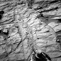
QUOTE (Sean @ Feb 27 2016, 09:58 AM)  Here is a nice picture from Sol 1264 Very nice work Sean Curiosity Mission Update from Ryan Anderson: Sols 1266-1268: Taking Stock of Stockdale: QUOTE Todays plan has a nice mix of science and driving. The rover will start off on Sol 1266 with ChemCam observations of the targets Ugab, Rooibank and Stockdale. We will zap the Rooibank target using two different laser energies to see if that helps us figure out the amount of hydrogen in the target. Afterwards, Mastcam has some documentation images of the ChemCam targets, and then we will do some contact science: MAHLI will take some images of Waterburg, then the DRT will brush the dust off of Stockdale and MAHLI will take some pictures of that target too. After the DRT, Mastcam will observe the Stockdale target with all of its science filters, and APXS will then do an overnight observation on the brushed location. On Sol 1267, Mastcam has a big mosaic of the edge of the Naukluft plateau, which will give us a nice view of the geology there and help us decide what to do as we get closer. After that, the rover will continue driving toward the plateau and do the usual post-drive imaging, plus some additional Mastcam off to the right hand side of the rover. On Sol 1268, we have a bunch of untargeted observations. ChemCam has a passive sky observation, and Mastcam will observe its calibration targets so the filter observations of Stockdale can be calibrated. Mastcam also has tau observations at two different times. To wrap up the plan, Navcam will do its usual atmospheric monitoring observations.
|
|
|
|
|
|
|
Feb 27 2016, 02:33 PM
Post
#309
|
|
 Member Group: Members Posts: 809 Joined: 3-June 04 From: Brittany, France Member No.: 79 |
Here is my take on RMI pictures of sol 1252 & 1263. I used pansharpening technic to merge them with MC34 pictures taken on sol 1163 (thanks Justin for pointing out these MC34 pics !).
I checked the location of sol 1257 RMI pictures with Midnight Planets App: they are close to top RMI mosaic but do not intersect with it. 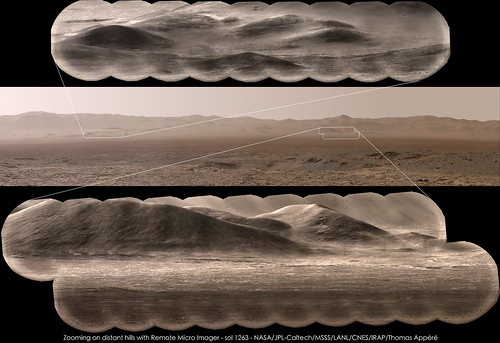
-------------------- |
|
|
|
|
Feb 27 2016, 02:47 PM
Post
#310
|
|
 Member Group: Members Posts: 890 Joined: 15-June 09 From: Lisbon, Portugal Member No.: 4824 |
QUOTE And a Navcam left panorama, also for Sol 1264 Thanks Sean. Now I can pinpoint the location, I think, and add the path till sol 1264. @Justin: really, really great work. And in color! Fernando |
|
|
|
|
Feb 28 2016, 07:07 AM
Post
#311
|
||
|
Solar System Cartographer Group: Members Posts: 10153 Joined: 5-April 05 From: Canada Member No.: 227 |
Here is Sean's panorama in a circular form. It let me move my rover location a bit further west than I showed it on the last map.
Phil
-------------------- ... because the Solar System ain't gonna map itself.
Also to be found posting similar content on https://mastodon.social/@PhilStooke Maps for download (free PD: https://upload.wikimedia.org/wikipedia/comm...Cartography.pdf NOTE: everything created by me which I post on UMSF is considered to be in the public domain (NOT CC, public domain) |
|
|
|
|
|
|
Feb 28 2016, 08:54 PM
Post
#312
|
||
|
Member Group: Members Posts: 923 Joined: 10-November 15 Member No.: 7837 |
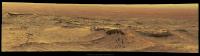
Happy to assist Mr Phil... I'm saving up for your books!
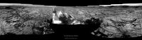
Here is the latest from Sol 1264 looking northwest... Flickr
Attached thumbnail(s)
-------------------- |
|
|
|
|
|
|
Feb 28 2016, 10:15 PM
Post
#313
|
|
|
Senior Member Group: Members Posts: 2428 Joined: 30-January 13 From: Penang, Malaysia. Member No.: 6853 |
|
|
|
|
|
Feb 29 2016, 05:30 PM
Post
#314
|
|
|
Member Group: Members Posts: 923 Joined: 10-November 15 Member No.: 7837 |
-------------------- |
|
|
|
|
Feb 29 2016, 06:37 PM
Post
#315
|
||
|
Solar System Cartographer Group: Members Posts: 10153 Joined: 5-April 05 From: Canada Member No.: 227 |
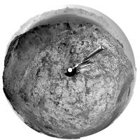
... and Hey Presto! A circular version. There are a few offsets, mostly visible in the plains to the north, which are exacerbated by my projection, but this gives a very good fix on our current location.
Phil
-------------------- ... because the Solar System ain't gonna map itself.
Also to be found posting similar content on https://mastodon.social/@PhilStooke Maps for download (free PD: https://upload.wikimedia.org/wikipedia/comm...Cartography.pdf NOTE: everything created by me which I post on UMSF is considered to be in the public domain (NOT CC, public domain) |
|
|
|
|
|
|

|
Lo-Fi Version | Time is now: 28th April 2024 - 01:16 AM |
|
RULES AND GUIDELINES Please read the Forum Rules and Guidelines before posting. IMAGE COPYRIGHT |
OPINIONS AND MODERATION Opinions expressed on UnmannedSpaceflight.com are those of the individual posters and do not necessarily reflect the opinions of UnmannedSpaceflight.com or The Planetary Society. The all-volunteer UnmannedSpaceflight.com moderation team is wholly independent of The Planetary Society. The Planetary Society has no influence over decisions made by the UnmannedSpaceflight.com moderators. |
SUPPORT THE FORUM Unmannedspaceflight.com is funded by the Planetary Society. Please consider supporting our work and many other projects by donating to the Society or becoming a member. |
|