Printable Version of Topic
Click here to view this topic in its original format
Unmanned Spaceflight.com _ Opportunity _ Matijevic Hill first survey
Posted by: Stu Aug 31 2012, 09:19 AM
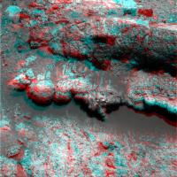
Oooooh, you're pretty...
|
|
Might be here a while, you think?
Edit: better colours on this amended version, I think... http://twitpic.com/apn9s1/full
Posted by: Stu Aug 31 2012, 09:35 AM
Oh boy...
|
|

Posted by: centsworth_II Aug 31 2012, 12:31 PM
Interesting how well those tilted back layers match the red lines in this diagram from http://www.planetary.brown.edu/pdfs/3954.pdf (interview linked in http://www.unmannedspaceflight.com/index.php?s=&showtopic=7411&view=findpost&p=190280) et al.

|
"...phyllosilicate-bearing layers (red lines) exposed in Endeavour rim."
From the text:
"...layers within the western rim dip away from the crater interior, as expected if the beds predate Endeavour crater and were back-tilted by the impact."
"...The Alpha Particle X-Ray Spectrometer could determine major and minor element chemistry, and the Pancam and Microscopic Imager could document grain sizes, shapes, and possible sedimentary textures (e.g., cross-bedding or laminations too fine to resolve from orbit)..."
Posted by: xflare Aug 31 2012, 12:43 PM
 Looks like things are about to get interesting.
Posted by: fredk Aug 31 2012, 02:21 PM

Clearly we're at the right spot - the cairn in the middle of your mosaic tells us that!
Posted by: mhoward Aug 31 2012, 02:51 PM
Wow. Yes, I think so. Unless there's a larger outcrop just down the way or something.
|
Posted by: Stu Sep 1 2012, 10:32 AM
Could this be Oppy's very own "Promised Land"..?
|
Posted by: CosmicRocker Sep 2 2012, 02:43 AM
Ahh, so there they are. Beautiful.


...sorry about three posts in a row... Mod: merged.
Posted by: Stu Sep 2 2012, 10:31 AM
|
|
Discuss.
Posted by: Stu Sep 2 2012, 10:50 AM
Where did the UMSF Swear Jar go... think we're gonna need it...
|
|
Posted by: Astro0 Sep 2 2012, 01:04 PM
Typical Opportunity. Some other rover gets the limelight for just a moment and she just has to show off.
|
Good on'ya girl!
Posted by: Tesheiner Sep 2 2012, 01:23 PM
I think we'll have a closer look at those rock outcrops.
http://qt.exploratorium.edu/mars/opportunity/forward_hazcam/2012-09-02/1F399841859EFFBVLOP1212L0M1.JPG

Posted by: ElkGroveDan Sep 2 2012, 02:53 PM
It almost looks intentionally placed there to help the story line like a bad sci-fi movie set.
|
|
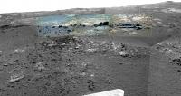
Posted by: CosmicRocker Sep 3 2012, 03:45 AM
I'm really curious about these mound-like features from the sol 3059 pancams.
-- pano in false color:
|
-- pancam anaglyph pano:
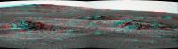
|
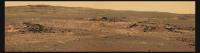
Posted by: NickF Sep 3 2012, 02:28 PM
Sol 3061 navcam pano
|
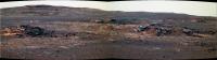
Posted by: Stu Sep 3 2012, 03:40 PM
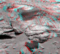
Everyone off the bus. I think we could be here a while.
|
|
|
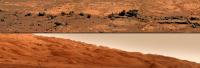
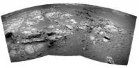
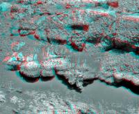
Posted by: Tesheiner Sep 3 2012, 06:23 PM
Nice site. Here's the 5x1 navcam mosaic and the respective polar view.
|
|
|
Posted by: marsophile Sep 3 2012, 07:45 PM
Very nice images. Are these rubble piles likely to be impact-related?
Posted by: Explorer1 Sep 3 2012, 08:34 PM
I still see those overhangs as being astonishingly unstable, even in the lower gravity. Watch yourself Oppy!
Posted by: RoverDriver Sep 3 2012, 10:19 PM
One nice thing about 6-wheel driving is that even if one gives way the others pick up the slack. Now if you are talking about IDD, that is a completely different thing. We definitely cannot have one of the wheels on unstable ground while IDD'ing or place the IDD on an unstable rock.
Paolo
Posted by: Explorer1 Sep 3 2012, 11:03 PM
Yes, the sections on the left (South?) look a lot less foreboding.
Posted by: CosmicRocker Sep 4 2012, 04:20 AM
That, is one strange looking outcrop.
Posted by: djellison Sep 4 2012, 05:24 AM
This outcrop looks about the same size/height as the great wall of Eagle Crater some 8.5 years ago. Nothing the team can't handle.
Posted by: dvandorn Sep 4 2012, 05:25 AM
I showed the latest image of this outcrop to my roommate, who pointed out its resemblance to a large pile of, er, thoat droppings.
My hope is that this is the edge of an upturned flap of rock strata that was violently flipped during the impact that formed Endeavour. It looks like the edge of a strata that dips in towards the center of Endeavour, though that's hard to tell with any certainty from this angle.
Anyone think this resembles the Woolly Patch that Spirit studied, which is suspected to have been a small clay outcrop?
-the other Doug
Posted by: stevesliva Sep 4 2012, 05:53 AM
Back in the day, young Opportunity was expected to walk to school through thigh-deep snow drifts, uphill both ways.
Posted by: Explorer1 Sep 4 2012, 06:27 AM
Sorry, I should have been more clear in my post; I was wondering how stable the overhang is if Oppy uses the IDD as Paolo said (we don't know how well attached it is to the surface or what the wind has been doing to it).
I'm know it's nothing that can't be dealt with and I certainly do remember Eagle Crater!
Posted by: charborob Sep 4 2012, 12:16 PM
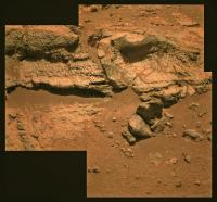
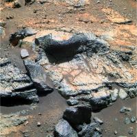
Here's a closeup of the outcrop.
|
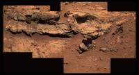
Posted by: Stu Sep 4 2012, 12:36 PM
I wonder how much the mission geologists are drooling, looking at these rocks..?
|
Edit: worked on that a bit more and got rid of that greeny colour... much better here: http://roadtoendeavour.files.wordpress.com/2012/09/untitled-1bv2.jpg
Posted by: vikingmars Sep 4 2012, 12:50 PM
Thanks Stu, for this very nice image.
Visually speaking only (no geology), they look like dry clays (very dry and much eroded)... I'm drooling too !
Posted by: centsworth_II Sep 4 2012, 01:18 PM
If those are hematite blueberries studding the rocks, then they would be the same ol' Meridiani layers, not pre-impact material. IMHO
Posted by: dvandorn Sep 4 2012, 01:56 PM
I'm not yet convinced that the blueberries are embedded into the rocks of this outcrop. They could just be scattered on top of these rocks, either as a lag deposit from previously overlying layers of concretion-bearing rocks that have since been eroded away, or lifted there by aeons of impacts that have redistributed such melt-resistant fragments liberally throughout the area.
A good MI campaign ought to shed more light on whether or not these outcrops have embedded concretions, or just have concretions draped over them.
-the other Doug
Posted by: Floyd Sep 4 2012, 04:05 PM
I'm a microbiologist--so what do I know--but to my eye, these don't look like blueberries-not round, not shiny, and the ones that have fallen out look more rounded-cubic or random bits than spherical. The sick green-grey (even with Stu playing with colours) doesn't look like the blueberries we have seen before. I'll go with VikingMars and guess dry eroding clay.
Here is a http://www.flickr.com/photos/michaelandanita/6890688082/to a nice image of eroding clay. With no rain and millions of years of wind erosion, I think we could get what we see in front of Opportunity.
Posted by: Tesheiner Sep 4 2012, 04:49 PM
Here is today's mosaic in L2 filter.
|
Posted by: nprev Sep 4 2012, 04:55 PM
Floyd, I agree with you re the berries. First thing I thought was "those sure are tiny & funny-looking blueberries..."
Becoming cautiously excited.
Posted by: PaulM Sep 4 2012, 05:32 PM
...phyllosilicate-bearing layers (red lines) exposed in Endeavour rim."
From the text:
...layers within the western rim dip away from the crater interior, as expected if the beds predate Endeavour crater and were back-tilted by the impact."
...The Alpha Particle X-Ray Spectrometer could determine major and minor element chemistry, and the Pancam and Microscopic Imager could document grain sizes, shapes, and possible sedimentary textures (e.g., cross-bedding or laminations too fine to resolve from orbit)..."
This paper suggest that the strata that Oppy is currently investigating predates the formation of Endeavour Crater.
I understand that the majority of the group of craters of which Endeavour is one are thought to date from the late bombardment. I think that Endeavour is a good candidate for a crater formed during the late bombardment because it is so eroded.
It is therefore possible that the strata that Oppy is currently investigating predates the late bombardment. If the clays formed during the deposition of this strata then this clay might also predate the late bombardment and might therefore be more than 4 billion years old. If this was true then this clay might predate the Gale crater clays by several hundreds of millions of years.
However, I understand that the prefered theory for the origin of these clays is that they formed due to weathering in crevaces after the formation of Endeavour crater and so might be contemporaneous with those of Gale crater.
Posted by: Don1 Sep 4 2012, 07:49 PM
I'm no geologist, but I'm going with a greenstone/green schist/chlorite schist with embedded garnets. The rock looks finely layered, so maybe it is a schist. The little pebbles could be embedded garnets which have eroded out of the rock. Chlorite is a group of phyllosilicate minerals, some of which contain iron and magnesium. Chlorite could be the source of the Fe/Mg rich phyllosilicates seen in the spectra.
Green schist is a metamorphic rock formed from basalt. Some of the oldest rocks on earth are green schist.
http://instruct.uwo.ca/earth-sci/200a-001/subductorig/dscf0143.jpg
Posted by: ngunn Sep 4 2012, 08:51 PM
Well I'm even less of a geologist than you obviously are but I really like your suggestion. I'd love those things to be garnets - my favourite mineral. However, don't you need huge tectonic movements to produce highly metamorphosed rocks like schist? In favour of the idea: at least schists are hard enough to produce upstanding outcrops, whereas I'd be surprised if eroding clay beds would be.
I expect these rocks to be the progenitors of the clays but not the clays themselves. My reason? A little farther on there is a crater formed into Cape York which CRISM shows to be surrounded by clays (weathered ejecta?) although the interior of the crater appears relatively clay-free.
The Gale crater clays likely have a completely different story to tell. It's an old, old world.
Posted by: Stu Sep 4 2012, 10:53 PM
A couple more sections added...
|
Posted by: Zeke4ther Sep 4 2012, 11:26 PM
I think you have the colour balance better here Stu. You can really tell that we have something special here.
Posted by: PDP8E Sep 5 2012, 12:14 AM
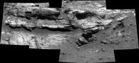
Here is one of those sub mosaic images of the current formation that OPPY is looking at.
The filters used for this shot are the far infrared, far UV, and plain old green... so my hat is off to Stu for pushing them into something that looks more 'real'. I went with crispness
|
Posted by: Bill Harris Sep 5 2012, 01:02 AM
{SNIP}
I've been looking at this outcrop line with interest since leaving the Whim Creek stop. Although we've seen distant views of this zone, my initial impression is that brown-toned layered rocks represent a weathered clastic unit unconformably overlying a basaltic impactite that is pre-Endeavour. This unit was, literally, the paleo-surface of a wetter, warmer Mars. We've had glimpses of it in passing below the basal Burns Formation during the last leg of the pre-Cape York part of the traverse.
Here is a enhanced HiRISE image of this part of Cape York. The area of interest is the light-toned (ie, reddish in the RED-filtered HiRISE image) areas near the center of the image (ESP_024015_1775_RED).
http://i142.photobucket.com/albums/r91/wilga_photo/Oppy/ESP_024015_1775_RED--summit_shoemaker_bench.jpg
You can match up the route of the traverse using Tesheiner's Route Maps.
Closer PanCams and MIs are going to be interesting.
--Bill
Posted by: CosmicRocker Sep 5 2012, 03:42 AM
Bill: I think the clastic unit underlying the basal Burns formation but overlying the Endeavour ejecta is being unofficially called the Deadwood formation after the target of that name from around sol 2770 or so (near Homestake). It's not exactly what you are talking about, but close. It was discussed in a recent paper that I can't put my fingers on at the moment, but I will try to find it for you.
ngunn: I think I would have to agree with you regarding garnet schist. As much as I'd love to see it, I don't think Mars has been tectonically active enough to have generated much in the way of schist or gneiss.
Right now I find myself agreeing with centsworthII. They look like blueberries to me, though they are on the ragged edge of resolution in these images. Whatever they are, they are embedded in the rock and not just loose granules lying on top. They are resistant to erosion and they are at the head of some mini-yardangs on the surface of the rock, as we have frequently seen with the blueberries out on Meridiani Planum.
We should be able to determine if they are hematite concretions in short order. There is an image set coming from sol 3063 with a full set of right filters...
pancam_Milnet_L234567Rall...
If Milnet is an image of a part of this outcrop, as I suspect it will be, a quick IR ratio image should identify any hematite that may be present.
Posted by: walfy Sep 5 2012, 04:37 AM
i tried to stitch a group of these frames together for a 3D, made a headache for the eyes instead! Spectacular outcrop here. The overhanging rock near the top has a nice white vein in it. The rock near the bottom also has such a vein. Perhaps it rolled off eons ago.
|
And a thanks for the great color panos of these rocks already posted! Really nice work.
Posted by: walfy Sep 5 2012, 04:48 AM
Thick blueberry froth!
|
Posted by: serpens Sep 5 2012, 05:41 AM
The
I expect you are right about the rocks being a precursor although that impact possibly excavated a clay bearing layer which is exposed as ejecta while the crater bowl has infilled? No matter how I torture the L257 the clasts seem to have the same response as the matrix so it seems unlikely they are the same hematite concretions as found in the sulphate sandstone. It would be outstanding if this turns out to be pre Endeavour impact materiel and MIs should be real interesting. This ageing rover has stolen the limelight yet again.
Posted by: charborob Sep 5 2012, 11:44 AM
Sol 3063 navcam panorama:

|
Posted by: Bill Harris Sep 5 2012, 01:48 PM
--Bill
Posted by: Jam Butty Sep 5 2012, 05:19 PM
Interesting stuff...
looks like there are some thin light colored veins running through the outcrop.
L2R2 flicker gif Sol 3062
Levels stretched to bring out the shadows,

|
For context its the rock in the top center of this image here...
http://marsrovers.jpl.nasa.gov/gallery/all/1/p/3062/1P400010707EFFBVLOP2407L2M1.JPG
Posted by: serpens Sep 5 2012, 11:05 PM
The paper was 'Ancient Impact and Aqueous Processes at Endeavour Crater, Mars' Science 336, 570. 'Deadwood' appears to be material eroded from the Shoemaker breccia layer while this outcrop is something new. Is it possible that these are a deposit of (silicate?) impact lapilli - a remnant of the pre Endeavour environment which after all impacted into the ejecta blanket of Miyamoto (and sundry other craters)?
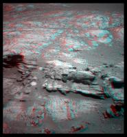
Posted by: Stu Sep 5 2012, 11:15 PM
Fascinating place...

|
Posted by: lyford Sep 5 2012, 11:49 PM
For some reason I am thinking of Wopmay....
Posted by: Tom Tamlyn Sep 6 2012, 01:23 AM
I was looking forward to this month's Mars Exploration Rovers Update from the Planetary Society's Salley Rayl, which has become our main point of contact with the MER teams. I hope it's simply a little later than usual rather than discontinued. Emily?
Posted by: elakdawalla Sep 6 2012, 01:44 AM
I was wondering too, and checked this morning. It's just running late. I'm not sure when we'll get it, but we'll get it!
Posted by: CosmicRocker Sep 6 2012, 03:53 AM
Posted by: ilbasso Sep 6 2012, 02:02 PM
Funny coincidence! As I was doing the dishes last night, "Wopmay" suddenly came into my mind, and I was remembering the wonderful images as we sidled along Burns Cliff. Seems another lifetime ago...
Posted by: TheAnt Sep 6 2012, 03:39 PM
When I first did see these images I did indeed think it might be the actual edge for Endeavour crater.
And made of material that were older than the impact that created Endeavour.
And then reading here that this spot might be related to clays also, even better!
Now that some of you say it might be blueberries here after all, I cannot get the ideas of what we got here to match with each other.
Also I have to admit having a very limited knowledge in geology, I still had the notion that the phyllosilicate layers would not come with blueberries.
Posted by: fredk Sep 6 2012, 04:24 PM
Well, the first MI's are down:
http://qt.exploratorium.edu/mars/opportunity/micro_imager/2012-09-06/1M400195777EFFBVM5P2905M2M1.JPG?sol3064
They are pretty spherical, but they seem to be embedded differently from what we've seen with blueberries...?
And I don't recall seeing outcrops quite like these before:
http://qt.exploratorium.edu/mars/opportunity/pancam/2012-09-06/1P400192779EFFBVM5P2272L5M1.JPG?sol3064
I can't wait to see these in colour...
Posted by: charborob Sep 6 2012, 05:17 PM
It really looks like we have two different units here: the dark-colored rock at bottom left and on the left, and the light-colored rock on the right and at upper right:

|
Posted by: Stu Sep 6 2012, 05:21 PM
You don't have to...

|
Posted by: Jam Butty Sep 6 2012, 05:22 PM
Sol 3064 L257 un-adjusted

|

|
Posted by: TheAnt Sep 6 2012, 05:24 PM
I tend to agree that it look somewhat different, lets hear what any of our semi-pro's think.
Perhaps it is so charborob, yet look at this navcam image
http://qt.exploratorium.edu/mars/opportunity/navcam/2012-09-06/1N400109567EFFBVM5P1961L0M3.JPG
The lighter material at left, might be the same as we see at center bottom and in the lower right corner. Those two latter ones might just be less wind eroded.
Posted by: mhoward Sep 6 2012, 05:42 PM
Amazing stuff. This is the view west and 20º down.
The "melt"-like stuff reminds me of that one small crater Opportunity explored some months before getting to Endeavour. I'm blanking on the name at the moment. But of course it may be completely different. This looks more like it's part of the rock.

|
Posted by: centsworth_II Sep 6 2012, 05:52 PM
Maybe you're thinking of these: "Oppy has finished her studies of the Chocolate Hills, and has moved off to the left, resuming her circumnavigation of Concepcion Crater."
http://roadtoendeavour.wordpress.com/2010/02/22/farewell-chocolate-hills/
But remember, that was melt in Meridiani sulfate rock and we're hoping this is something else.
Posted by: Stu Sep 6 2012, 06:21 PM
A couple of MI mosaics...

|

|
We really need a "shakes head in wonder" icon...
Posted by: ngunn Sep 6 2012, 07:36 PM
. . but range widely in size and seem to like splitting in half. Interesting times.
Posted by: dvandorn Sep 6 2012, 07:45 PM
I believe we established quite a while ago that hematite concretions like the blueberries are resistant to melting. This looks like breccia with partially broken-up concretions as the clasts within the breccia. The matrix appears quite uniform.
My best guess is that there were concretions in the soil when the Endeavour impact occurred, and what we see here is impact melt that gathered up the unmelted concretions in the debris cloud as it cooled, making it impact melt breccia with concretion clasts.
In other words, it's blueberry muffin rock.
-the other Doug
Posted by: john_s Sep 6 2012, 08:03 PM
Those MIs are astonishing- so fabulous to see something so radically new from a nearly 9-year-old rover! I'm betting against blueberries- these rocks, and the pre-exisiting rocks they might have been derived from in the Endeavour impact, are much older than the blueberry-containing formations so it's perhaps unlikely that they would also have contained blueberries. These guys tend to have resistant outer shells, which I don't think I've ever seen in blueberries (though on oDoug's hypothesis, maybe the outer layers were melted and hardened in the impact?).
I'm betting on these being tektite-like spheres of glassy impact melt...
John
Posted by: mhoward Sep 6 2012, 08:04 PM
A couple quick color anaglyphs

|

|

|
Posted by: centsworth_II Sep 6 2012, 08:06 PM
Posted by: nprev Sep 6 2012, 08:29 PM
What the heck...??!?!! (And, Stu, brilliant work; thanks!!!)
I think that they pretty much have to be blueberries, albeit perhaps of a different vintage than we are used to. They didn't get a chance to get very much larger.
Perhaps a significant clue to the history of the Endeavour impact site.
Posted by: Stu Sep 6 2012, 08:35 PM
Thanks, Nick. You liked that..?
You'll love this...

|
Posted by: CosmicRocker Sep 6 2012, 10:10 PM
Beautiful mosaic.
These appear very different from the blubes we're accustomed to seeing. Glassy impact spherules would be my best guess, too, after seeing the MIs.
We're still missing the R5 filters, so I can't do a hematite image yet.
Posted by: dburt Sep 6 2012, 10:32 PM
These somewhat resemble devitrification spherulites (a type of spherule) that form during the localized crystallization of water-bearing glass, although the glass involved is usually more silica-rich (e.g., obsidian) than what was likely the case here. Such spherules can be hollow on the inside, owing to steam released during crystallization; large hollows are called lithophysae. (Many years ago I did much field and theoretical work on lithophysae containing gem topaz.) Spherulites can be more resistant to erosion than the rapidly altering remnant glass that surrounds them. Just another possibility to add to those already suggested.
Posted by: Explorer1 Sep 6 2012, 11:11 PM
Is that a glint of sunlight on one of the nodules near the top center (of Stu's pan), or just an artifact?
What a place!
Posted by: akuo Sep 6 2012, 11:17 PM
What? Another type of spherule in Meridiani? This is just too much. Oppy has clearly been out of the limelight too long, they need to hold another press conference and get Steve there to explain it all.
Posted by: atomoid Sep 6 2012, 11:59 PM
What a place!
what a place indeed... Oppy steals the show!!
i think your referring to the right side of the top left quadrant http://www.unmannedspaceflight.com/index.php?act=attach&type=post&id=27934
i see those from time to time, i think its just too bright for the sensor at the exposure level so it bleeds out a bit, perhaps..
im curious about the bloob just to the left of that bright glinting one, it has lines running diagonal to lower right. its kinda really strange, i dont see anythingn quite like it, i dont quite know what to make of it...
the cache of blueberries is so startlingly concentrated here, and since im not a geologist and have no reputation to lose I will go far out on my own breaking limb to suggest they didnt form in situ but were collected by erosional processes rolling into collecting cracks with a subsequent Endeavor impact resultant water percolation cooking them up with rinds and modified materials into something like a blueberry mud muffin cake layer filling, whatever it was it sure looks delicious!!
..but i sure do like the sound of the phrase ".. impact melt breccia with concretion clasts.." (thanks 'other Doug')
Posted by: Bill Harris Sep 7 2012, 01:48 AM
I think these MIs are a view of the light-toned flat rocks, we haven't even gotten to the dark, coarse-textured ones yet!
--Bill
CR: you may be right. On second glance, it's not looking like the light-toned flat rock.
Posted by: CosmicRocker Sep 7 2012, 02:50 AM
I'm hoping someone can post a context image showing us where these MI's were taken. It seems that the MIs display a denser concentration of spherules than many of the rocks we see in the pancams.
Posted by: CosmicRocker Sep 7 2012, 03:00 AM
Posted by: serpens Sep 7 2012, 03:42 AM
These have a passing resemblance to the Gunflint Lake lapilli deposit originating from the Sudbury impact. (image source Minnesota Geological Survey). If these are lapilli would that not imply that the deposit was laid down at a distance from the impact site which would be a strong indicator that these were part of the pre-Endeavour impact terrain?
http://i1191.photobucket.com/albums/z468/serpens1/impactlapilli.jpg
Posted by: elakdawalla Sep 7 2012, 05:18 AM
I was thinking the same thing. As far as I understand it, a crater rim consists of preexisting target rock layers, usually overturned by the impact excavation process. I would think that most glass would be deposited with the impact ejecta, not in the crater rim. So if these are impact spherules, I don't think they could be from the Endeavour-forming impact, unless Endeavour's current "rim" is not actually the original rim but instead an erosional remnant of the ejecta deposited outside the rim, which turned out to be more resistant to erosion than the actual rim.
But this is all pretty arm-wavey geology. I need to go talk to an impact person, ideally someone who's familiar with the rover mission. I don't actually know anyone who answers that description. Hmm.
Posted by: Gladstoner Sep 7 2012, 09:47 AM
.
Posted by: belleraphon1 Sep 7 2012, 11:55 AM
Know not suppossed to clutter but gotta say WOW OPPY.
Not even going to pretend to be a geologist.
This just proves the benefit of having long lasting rovers..... I remind my non-space following friends that Mars is a world and seeing ONE landing site area does not define the planet.
Keep going OPPY team!!!!
Craig
Posted by: Julius Sep 7 2012, 01:55 PM
Could anyone recall the composition of Wopmay back in Endurance crater and the chocolate hills at Conception crater!?? I see a resemblance in these rocks here !!
Posted by: Bill Harris Sep 7 2012, 02:09 PM
A quick reference to clastic dikes:
http://en.wikipedia.org/wiki/Clastic_dike
They can be relatively benign, like from fluidized injection from the weight of overlying strata, or by the sweeping of sediment into open fractures (like dessication cracks or the Anatolia lineations) or catastrophically, related to impact processes:
http://en.wikipedia.org/wiki/Upheaval_Dome
Your image is labeled "bonner clastic dike"-- what location/formatin is that? "Bonner" makes me think "Idaho".
From yesterday's color Pancams, the Blue of these spherules suggests to me more of an impact melt instead of an hematite concretion. FWIW.
--Bill
Posted by: Bill Harris Sep 7 2012, 02:13 PM
--Bill
Posted by: centsworth_II Sep 7 2012, 02:27 PM
Posted by: Don1 Sep 7 2012, 08:29 PM
If this rock is Noachian aged, maybe it dates from the period of the Late Heavy Bombardment. Impact lapilli might be common in rocks from that period.
That said, I thought that impact lapilli were supposed to come in discrete layers. These look to be scattered evenly though the rock.
Nobody has said anything about the matrix. I think there is an excellent chance that the matrix is the source of the clays, but last night I compared the route map with the map of the clays from CRISM and noticed that the rover is a little north of the area where clays have been detected.
Posted by: ngunn Sep 7 2012, 08:58 PM
(2) I think there is an excellent chance that the matrix is the source of the clays, but last night I compared the route map with the map of the clays from CRISM and noticed that the rover is a little north of the area where clays have been detected.
1/ The upstanding 'fin-like' outcrop could in its entirity be considered a discrete layer. I'm not yet sure whether we are looking at a coherent stack of everted rim bedrock or a rubble-pile of ejecta in which the 'fin' is just one largish fragment that happens to be partly on edge at a plausible angle. Either way I'm with the pre-Endeavour impact lapilli idea for now.
2/ This is quite a small outcrop and any patch of clay minerals deriving from it may be too small for CRISM to resolve. There could still be clays to be found here, though undoubtedly there's a bigger patch up ahead. Will that prove to be associated with more exposures of lapilli-packed rocks? With luck we'll soon find out.
Posted by: centsworth_II Sep 7 2012, 09:08 PM
If they are lapilli, they may have been mixed with other material by impact or some other process, the mixture later becoming lithified.
Posted by: Stu Sep 7 2012, 10:06 PM
You can almost feel your boots skidding on these beautiful rocks as you clamber and step over them, can't you..?

|
Posted by: Gladstoner Sep 8 2012, 03:08 AM
.
Posted by: CosmicRocker Sep 8 2012, 03:38 AM
It seemed to me that we should be able to make some guesses about the ages of these rocks from their dips and strikes, so I took a look around.

Posted by: serpens Sep 8 2012, 07:40 AM
From the split examples in the MI they look more like a product of accretion than condensation - maybe perhaps.
Posted by: ngunn Sep 8 2012, 09:23 AM
As a non-geologist I'm here to learn from those who are, and I'd appreciate some help with definitions. Here: http://www.google.co.uk/url?sa=t&rct=j&q=&esrc=s&source=web&cd=2&ved=0CCkQFjAB&url=http%3A%2F%2Fen.wikipedia.org%2Fwiki%2FLapilli&ei=sghLUI_bF8fB0QWf44HwDQ&usg=AFQjCNHzF9dOVYCwzp0cDL17oh2XnY7KDA&cad=rja I read that lapilli are small round stones produced by volcanic eruptions or meteorite impacts and that they can be formed either by accretion from a vapour cloud or by solidification of drops of melt. Is that how you're using the term, and if so what is the distinction between the latter case and the glassy spherules you refer to?
(I do apologise for descending into semantics but I want to make sure that my posts do not muddy this fascinating discussion through loose use of terminology on my part.)
Posted by: xflare Sep 8 2012, 02:54 PM
Does anyone know of a cross section of a tektite? This is the only image I could find online:
http://www.panoramio.com/photo/3894593
The latest MI shot shows the cross section structure a bit better http://qt.exploratorium.edu/mars/opportunity/micro_imager/2012-09-08/1M400195674EFFBVM5P2935M2M3.JPG
They do bear a superficial similarity to the very last image on this page http://www.meteorite-times.com/Back_Links/2002/November/Tektite_of_Month.htm
Posted by: Gladstoner Sep 8 2012, 06:00 PM
.
Posted by: dburt Sep 8 2012, 07:34 PM
Tektites are glassy bits of impact melt that hardened in the air; their shape need not be spherical, and they are probably irrelevant to the subject of this discussion. Lapilli are gravel-sized fallen melt stones, without reference to specific shape or origin (only size), and the term alone therefore is ambiguous.
As is being discussed, there are many types of spherules and other intrinsically rounded objects, of various origins. Spherules formed by some combination of chemical and physical accretion, such as concretions (formed by pure chemical accretion owing to abrupt changes in chemical properties of groundwater that reduce mineral solubility) and accretionary lapilli (formed by a combination of condensation and physical accretion - possibly involving electrostatic charge - of particles in a turbulent, cooling and mixing gas cloud, and thus not unlike hailstones in concept) are NOT HOLLOW on the inside, unless perhaps internally weathered or altered (as most are on Earth).
The spherules under discussion, or at least many of them, ARE distinctly hollow, and some appear to have objects in their center. This feature (hollow, possibly with junk on the inside) is characteristic of spherules formed by devitrificationof a hot hydrous glass, especially of the variety called lithophysae. As microcrystallites of anhydrous silicate minerals grow radially outwards, in many cases around a central object or megacrystal that served as a nucleus, they release steam that can inflate the spherule as it grows, leading to a hollow inside (except perhaps for the remant central object). The images haven't shown any yet, but some lithophysae even develop an onion-like or layered outer structure (but with open space between the layers), as a rind of crystallites develops, then steam escapes past it, inflating the still soft hot glass, then another rind of crystallites grows, and so on.
Oppy may have been imaging impact glass cementing breccia ever since it arrived at Cape York. Martian impact glasses and melts, compared to those found elsewhere, should be especially hydrous and full of salts, both of which characteristics would favor devitrification (crystallization), so finding spherules formed by devitrification of hot glass or melt shouldn't be surprising. I repeat, this is just one suggestion among many, and need not be correct, but it appears to be the only one so far that accounts for the intrinsically hollow structure with junk inside and an apparent rind on the outside that has just been imaged here. Greater magnification revealing a concentric outer rind of microcrystallites (as mentioned by Bill Harris above), or new images revealing a separated outer onion-skin structure, both would support the hypothesis. I hope this background information helps the discussion.
Posted by: ngunn Sep 8 2012, 08:09 PM
It certainly helps me make sense of it. Much appreciated.
Posted by: serpens Sep 8 2012, 10:49 PM
After years of sulphate sandstone and a winter looking at a chunk of suevite this is ultra cool. There does not seem to be much deformation in the spherules and if they are devitrified glass wouldn't this indicate a lack of compaction? ie. If they were formed pre-Endeavour then they would have been deposited pretty close to the old surface . A thin section of unweathered rock would come in handy about now. I wonder if the APXS will be able to provide an indication of the nature of the matrix? The next Opportunity related LPSC papers should be real interesting.
Edit: Just to put CosmicRocker's look around in context, is this a view of the outcrop from the Sol 2751 position?
http://marsrover.nasa.gov/gallery/all/1/n/2751/1N372413033EFFBPJ7P1907R0M1.JPG
Posted by: Bill Harris Sep 9 2012, 01:16 AM
This is going to be a very interesting stop on the traverse. I want to say "the most", but it keeps getting better. This is one reason why I've been jumping up&down waving my arms about doing a thorough leg of the traverse across CY, from the Meridiani side, across the rim remnant and into the Endeavour bowl. The depositional, weathering and erosional history of this area is so incredibly complex that we need to understand this history to understand the details.
Good points, dburt. I'm glad that you weighed in. The "hollow" appearance of the spherules doesn't bother me, but it provides another clue (or puzzle-piece). What it tells me is that the interior has a different "hardness" tenacity" "gooeyness" (whatever) than the outer rind. These spherules have been here a LONG time and have been through a lot of secondary, tertiary and quad-ternary mineralization. And that is beyond what a fresh spherule was like. We are seeing broken spherules that have been gently "sandblasted" by aeolian erosion for aeons. We need to see more MI examples, under several different lighting conditions. And the snaggle-toothed RAT needs to section a couple of fresh spherules.
I'm waiting for tdemko to weigh in. I see several "sedimentary" structures that are taunting me. Something has happened there.
And I see that "they" are calling it "outcrop" without choosing a name, yet. I'm still pushing for the Gracie Allen Formation... 
--Bill
Posted by: dvandorn Sep 9 2012, 03:25 AM
I thought they were calling the whole area Fin Ridge or something like that... though I guess they need some kind of separate name for just the outcrop within the ridge.
BTW, Gracie Allen Formation? I *like* it!
-the other Doug
Posted by: dvandorn Sep 9 2012, 03:54 AM
I'm on tenterhooks waiting for some imagery and APXS work that would indicate whether or not these spherules are deformed hematitic concretions or some form of lapilli. If lapilli, the big question would be whether they were formed by volcanic or impact processes. There is plenty of evidence on Mars for both processes.
Of course, this rock bed could have been formed by a combination of the two processes -- volcanic lapilli could have been spread around the fringes of the impact target sites for any one of the very large craters in the area, and been caught up in a moving tide of impact melt to become clasts in a melt matrix. The same thing could have happened with concretions being embedded in impact melt, and impact-generated lapilli could always have been caught up in a pyroclastic flow of some kind that left them embedded in tuff.
Isn't it fun how impacts are both a blessing and a curse? A single impact into an intact pile of rock beds shows you wonderful evidence of the emplacement and composition of the beds over time, and exhumes rocks from deep within the strata. On the other hand, throw impact after impact onto a set of rock beds (as happened during the LHB) and you get a ground-up, brecciated set of jumbled strata, greatly enriched by impact melt (which can have profoundly altered composition from the target rocks). And with each large impact you're creating new impact melt that is an amalgam of the elements not just in the surviving rock beds but also in the impact melt already emplaced by prior impacts, and in ejecta from other impacts that could have been transported there from hundreds of kilometers away (and exhumed from very different depths of strata). It seems to me it would be almost impossible to straighten the whole mess out into its original emplacement and compositional stratigraphy.
-the other Doug
Posted by: Bill Harris Sep 9 2012, 04:10 AM
Just a thought. Eight years of trundling over the Burns Fm can do that to you...
--Bill
Posted by: ElkGroveDan Sep 9 2012, 04:12 AM
I've heard a lot of well thought out theories on these, but six bucks and my right ... spherule says these are the same hematite concretions we've seen across the rest of Meridiani.
Posted by: Zeke4ther Sep 9 2012, 04:56 AM
EGD, I think you might lose that bet.
I am betting this is not hematite simply because these are hollow spherules; and all of the broken hematite spherules we have seen in the past have been solid.
Posted by: CosmicRocker Sep 9 2012, 05:37 AM
Just to echo the sentiments of others, seeing these ancient rocks from the early days of the inner solar system's formation is incredibly fascinating. I've long wondered what the rocks from the bombardment phase looked like. Now, we may be getting to see them for the first time.
Posted by: serpens Sep 9 2012, 07:16 AM
Welcome to the Hadean.
Posted by: Antonb Sep 9 2012, 09:18 AM
This rather nice photo shows "a close-up of a partially devitrified black obsidian from the island Lipari, Italy, with lots of small spherulites in it" that to me at least show similar internal structure to the objects found by Oppy. See the section on "Spherulites and Wall-lining Banding" on http://www.quartzpage.de/agate.html for details on the growth of spherulites.

|
Posted by: xflare Sep 9 2012, 09:43 AM
wow, some of those look very similar to the "spherules" in this Oppy image
http://qt.exploratorium.edu/mars/opportunity/micro_imager/2012-09-08/1M400195674EFFBVM5P2935M2M3.JPG
Posted by: Bill Harris Sep 9 2012, 01:53 PM
--Bill
Posted by: tdemko Sep 9 2012, 02:23 PM
Well, since you asked...!
I'm going to have to go with ElkGroveDan's bet and say that I think that these spherules are the same type concretions that have been encountered in the younger, sulphate-bearing units at Meridiani. A while ago, I posted a summary of what the various stratigraphic and stratal geometric relationships between the units at Cape York that could be imaged by MRO, before Opportunity arrived there. As has been illustrated in the published papers, in general, the concretion-bearing sulphate strata onlap the impact-deformed older strata at the crater rim. The crater rim strata were a positive topographic feature throughout the initial time of deposition, and presumably, were eventually buried. This resulted in the apparent angular unconformity we see right now. The surface of the unconformity, however, seems to be quite complicated, which probably should be expected. Not only did it experience impacted related phenomena and ejecta deposition, but also weathering and colluvial deposition pre- and during the Meridiani "transgression" (or glacial advance, depending on your interpretation!). I think right now Opportunity is seeing some of the colluvial and initial Meridiani units in an angular, unconformable relationship with the tilted older strata. The same diagenetic phenomena that created the hematite spherules in the Meridiani strata would also have affected the immediately underlying deformed strata. Unconformities almost always are also boundaries important to subsurface fluid flow (aquacludes/barriers and aquitards/baffles), and can show distinct features reflecting perching/ponding of fluids and/or concentration gradients. The underlying deformed strata likely had zones or units of differing porosity and permeability, as well as original compositional and textural differences. The fluids that created the ubiquitous hematite spherules in the sulphate units must have also diagenetically altered the units at and below the unconformity.
Posted by: centsworth_II Sep 9 2012, 03:51 PM
Ah! That lit a light for me!
I was thinking that if the matrix was not the same sulfate sandstone that the hematite concretions formed in, that the sphereules could not be the same hematite concretions. But now I see that the same groundwater which formed the concretions in the Meridiani sulphate layers would have permeated and perhaps formed the same concretions in Endeavour's rim material. Thanks for the illumination.
Posted by: Bill Harris Sep 9 2012, 07:11 PM
Hi, Tim. So you think that the spherules are just the hematite concretions? Good possibilty. But we'll examine more examples and decide why they (apparently) have a different internal structure and why they (apparently) weather differenly. More color Pancams up today, she'd preparing to RAT/Brush and part of The Outcrop With No Name has been tagged "Kirkwood", P2560.
This is complicated. If we were there, we'd all be at the outcrop flat on our bellies with handlens, brush and hammer busy.
--Bill
Posted by: fredk Sep 9 2012, 07:21 PM
Posted by: Bill Harris Sep 9 2012, 08:58 PM
Oh, my there are about a gazillon MIs to look through. Seems like they were earlyish MIs, like pre-Purgatory. They were "similar"-- rind and core, but maybe I think "different" because Hope Springs Eternal. These "seem" to have a more pronounced internal structure, but remember, the wind in this vicinity is strong and persistent enough to keep the pavement down on the bench swept clean and this outcrop uncovered, so the internal structure may be visible due to unusual aeolian erosion.
We'll be seeing a LOT more on the next few days.
--Bill
Posted by: ngunn Sep 9 2012, 10:06 PM
We're still missing the R5 filters, so I can't do a hematite image yet.
That was three days ago. So are we still missing the R5s? I thought we'd have this nailed by now.
Posted by: serpens Sep 9 2012, 11:18 PM
R pancam aside, the L257 don't have the same response as the hematite concretions, so if they are concretions there are differences in makeup. The lack of blubes on the top of CY would seem to imply that it was not overrun by the Burnes materiel so if they are concretions (not necessarily hematite) then this implies significant groundwater at the inner rim of the crater with the consequent implication of a lot of water within the crater. (Also indicated by the response of the fill that over-ran the NW crater wall).
I think that identification of the matrix materiel will be a key factor in determining the provenance of these spherules but I think I will tend towards a cluster of impact related spherules/lapilli. While we have seen a few hollow, split blueberries on the plains these have been few and far between and we haven't seen anything like this outcrop before. The 'junk' that dburt drew attention to could possibly be clasts ripped up in a ground surge rather than concretion nucleation sites but as Bill Harris said, these examples have been subjected to long, slow erosion. Preferential erosion seems more likely in lapilli than concretions. Roll on the APXS
Posted by: Gladstoner Sep 9 2012, 11:48 PM
.
Posted by: charborob Sep 10 2012, 03:38 AM
This part of the outcrop does look like a fin. Funny weathering anyway.

|
This anaglyph might be a bit difficult to view, because the "fin" is just on the edge of the pancam images.
Posted by: CosmicRocker Sep 10 2012, 05:10 AM
Looking at the rocks around Opportunity now, we have seen several apparently different rock types that all seem to have spherules in them. That would fit nicely with your hypothesis. I hope we have more than one MI target around here.In the mean time, I have spent the evening studying the calculated IR false color image algorithm that I have been using to identify hematite. After comparing the right filter band-passes to some hematite IR reflectance spectra, it appears that the R4 filter should work as well, if not better than the R5, so I think I can work with the recent image sets. I'm working on some outcrop images and will hopefully be able to post something tomorrow.
Posted by: kungpostyle Sep 10 2012, 12:57 PM
The Planetary Society monthly report is up:
http://www.planetary.org/explore/space-topics/space-missions/mer-updates/2012/08-mer-update-opportunity-greets-curiosity.html
Posted by: Stu Sep 10 2012, 05:06 PM
Wow...

|
And look at the bottom of this one... shiny veins..?

|

Posted by: Burmese Sep 10 2012, 05:15 PM
I think Oppy is going to be considerably delayed hitting that 37k mark. Whether those turn out to be blueberries or not, these structures are very different from anything we've encountered before, and I'm sure the team will be spending a good stretch of time here applying the rovers' reduced toolset to try and figure out what this is and how it came to be.
Posted by: charborob Sep 10 2012, 05:25 PM
A 3D look:

|
Posted by: fredk Sep 10 2012, 05:30 PM
Love those crazy web-like bright veins.
Here's an L7/R1 anaglyph:

|
Posted by: Bill Harris Sep 10 2012, 07:19 PM
Please do! I worked with the "IR ratio image technique" for a while, but got sidetracked and still use my "TLAR" method.
--Bill
Posted by: dburt Sep 11 2012, 03:14 AM
For comparison the first is a photo taken this afternoon of some hollow spherules, type devitrification lithophysae, from Cerro El Lobo, Tepetate, San Luis Potosi, Mexico, from a broken hand specimen I collected in 1985 (cf. my earlier posts 182 and 207). This is a topaz rhyolite (the light is glinting off a small topaz crystal in the large lithophysa to the left), much richer in water and fluorine than anything expected on Mars, and the groundmass has completely devitrified (following formation of the lithophysae). The typical onion skin texture is evident.

|
The second photo from this afternoon is shows more typical devitrification spherulites, from a weathered specimen collected last March by my colleague in the Superstition Mountains east of Phoenix, Arizona. The spherulites, especially broken ones in the lower center, clearly show the radiating microcrystalline texture that is typical. The groundmass is a somewhat perlitic (gray hydrated) obsidian, not devitrified. The spherulites, unlike the lithophysae, are resistant and weather or break out of the rock.

|
Hope these photos prove instructive; I was a little dissatisfied by what I found on the web (although Gladstoner's in 206 isn't bad). In both photos, note the extreme variation in size over a small area (also typical of concretions, but not Mars blueberries). In any case, the MI Mosaics of Stu in post 173 seem to show a rather large variation in size over a small area, also suggesting (together with the unusually close packing) that these might something other than the typical blueberries.
Posted by: CosmicRocker Sep 11 2012, 03:41 AM
Sorry it has taken so long, but I generated 15 of these images covering much of the outcrop, and that took a long time. I was hoping I could stitch them all together, but that is not working, so I'll post it in pieces.
These are false color composites using right filter images and ratios of the images. Although some of you may not believe the uncalibrated, raw jpeg images can be used to do anything consistent, this algorithm has very consistently identified hematite on Meridiani Planum. I have looked at hundreds of these images and in all of them hematite appears as a bright, canary yellow color. I suppose that some other mineral that has a similar IR reflectance spectrum to hematite's might also appear yellow with this technique, but I don't think we have seen any such minerals on Meridiani.
As you can see, there appears to be a lot of hematite around here.

|
As I look at this I wonder if it may be similar to something we've seen once before. If you look closely at the left side of this pano and also the bottom right you can see ares where a bluish rock appears to be behind an encrusting layer of hematite. Do you remember seeing something similar on a target called http://www.unmannedspaceflight.com/index.php?s=&showtopic=6434&view=findpost&p=155863?
Posted by: Eutectic Sep 11 2012, 05:04 AM
Although I have yet to find the MI images I *think* I remember of fractured blueberries, this hematite concretion picture on the left from 2004 (!) is consistent with the harder rind/softer interior spherules we're seeing presently in the right frame.

|
Posted by: Bill Harris Sep 11 2012, 05:56 AM
Thanks, Tom. Now we "know" what color this puzzle piece is. Chocolate Hills, if I recall correctly, was decided to be a fracture fill.
--Bill
Posted by: CosmicRocker Sep 11 2012, 06:37 AM
Yes, Chocolate Hills was a fracture fill, but it was a fill composed largely of closely packed, hematite concretions of various sizes, held together by an intergranular cement of hematite. All of these rocks do not look like Chocolate Hills, but some parts of them do.
That first pano I posted was just left of where the rover is doing IDD work. The following picture is just to the right.

|
Posted by: centsworth_II Sep 11 2012, 07:04 AM
I don't know about Opportunity previously seeing hollow hematite concretions, but here is a figure showing some solid-looking fragments along with experimentally grown "blueberries".
Edit: I just noticed that the Meridiani blueberries are measured in mm while the lab-grown berries are in um. So the lab berries are in reality about one thousandth the size of the real blueberries.

|
http://www.sciencedirect.com/science/article/pii/S0032063312000736
Posted by: Bill Harris Sep 11 2012, 12:19 PM
CR: very good. On your IR ratio images, do you know what shows as the cyan color? The magenta is shadowed areas.
Centsworth: Not a problem. Every Blueberry started out as a um-sized seed. It is telling that the lab-grown variety fracture te same way as the Meridiani BBs.
--Bill
Posted by: centsworth_II Sep 11 2012, 01:26 PM
I found a paper describing the methods that produced the synthetic sphereules in my last post. Also more comparisons with fractured Meridiani concretions.
"Comparison of morphology of whole and broken spherules.... Fracture surface textures in both sets of spherules are consistent with a spherulitic (radial) growth."

|
http://ia600607.us.archive.org/30/items/nasa_techdoc_20080012477/20080012477.pdf
In my ignorance, I find it hard to imagine the radial-structured spherules described above becoming hollow with an outer shell. But I found another paper, quoted below, which describes a possible rind formation process for hematite concretions. I don't know if it's an either/or situation or if both processes can be at work.
"....Field observations and numerical simulations indicate that spherical iron oxide concretions can form in a variety of host-rock conditions..... Laboratory tests indicate that chemical gradients between the inside and the outside of these spheres cause diffusion of Fe ions toward the outer perimeter of the amorphous sphere, forming a rind. The rind then grows inwards due to diffusion within the sphere, and may produce 'onion layering'. Continued diffusion, dehydration, or changing temperature are a few of the factors that may further affect the secondary internal structure-forming processes...."
http://archive.li.suu.edu/docs/ms130/AR/chan7.pdf
Posted by: CosmicRocker Sep 11 2012, 07:15 PM
See, for instance, the following IR ratio image from sol 423 showing the sandstone in shades of green and cyan, loose dust and sand in purples and greens, and acres of yellow, blueberry armored drifts.

|
edit: I just remembered that Homestake vein was also cyan.
Posted by: Don1 Sep 11 2012, 11:55 PM
On Sol 30 there was an MI image of a RAT hole with two blueberries that had been sliced open. They look a lot different from the present spherules. There is almost no internal structure visible, and no sign of a core or a crust.
http://marsrover.nasa.gov/gallery/all/1/m/030/1M130859941EFF0454P2949M1M1.JPG
Edit: Also on Sol 162, another sliced blueberry with only very faint internal structure.
http://marsrover.nasa.gov/gallery/all/1/m/162/1M142564147EFF3221P2977M2M1.JPG
Posted by: Ondaweb Sep 12 2012, 01:30 AM
Thanks for that pic Don. I was thinking I had seen such an image and remembering no hint of internal structure.
Posted by: belleraphon1 Sep 12 2012, 01:04 PM
I cannot stop roving through these images
.
http://qt.exploratorium.edu/mars/opportunity/pancam/2012-09-11/1P400446955EFFBVM5P2277R2M2.JPG
http://qt.exploratorium.edu/mars/opportunity/pancam/2012-09-11/1P400643308EFFBVM5P2280R1M1.JPG
http://qt.exploratorium.edu/mars/opportunity/pancam/2012-09-11/1P400643113EFFBVM5P2280R2M1.JPG
http://qt.exploratorium.edu/mars/opportunity/pancam/2012-09-11/1P400547173EFFBVM5P2281L7M1.JPG
http://qt.exploratorium.edu/mars/opportunity/pancam/2012-09-11/1P400546896EFFBVM5P2281L2M1.JPG
Show these images to some friends who get it. Others can only see a of bunch dirt and stone and say
so what.
For me
can close my eyes and feel the ages old breeze wafting past
. the burn from the cold light of Sol. Want to dip my hands in the dirt and sniff the place
.. Tell me your tale Mars.
Wow
. Love this place.
Posted by: Stu Sep 12 2012, 01:34 PM
I absolutely know what you mean, my friend, and so, a gift for you, and everyone else who "gets it"...

|
As the great KSR put it so well...
On Mars... on Mars... on Mars...
Posted by: belleraphon1 Sep 12 2012, 02:00 PM
Absolutely gorgeous!!!!!!
I stand transported....
Thank you Stu....
Craig
Posted by: fredk Sep 12 2012, 04:34 PM
A bump on sol 3070 and some nice low-sun shots:
http://qt.exploratorium.edu/mars/opportunity/rear_hazcam/2012-09-12/1R400737543EFFBVO2P1311R0M1.JPG?sol3070
Posted by: marsophile Sep 12 2012, 05:11 PM
With respect to the new berries, recall that Cape York does not have an orbital hematite signature. So if there are substantial numbers of berries there,...?
Posted by: Bill Harris Sep 12 2012, 07:50 PM
Got a new stack of Pancam images from a new outcrop and possibly some MIs. As the phrase goes, yummy.
--Bill
Posted by: walfy Sep 12 2012, 11:43 PM
Nicely composed front haz-cam:

|
The rock looks almost chalky in nature, makes me want to pull out a pocket knife and see how it carves! But, considering its wind resistance, maybe it's pretty tough...?
Posted by: walfy Sep 12 2012, 11:55 PM
Just one more for this evening:

|
Very weird rocks!
Posted by: eoincampbell Sep 13 2012, 01:23 AM
I stand transported too!
An amazing color & stereo tour of an amazing place, thanks everyone !
Posted by: serpens Sep 13 2012, 03:16 AM
I have to admit to reservations over the identification of these spherules as hematite concretions. Compare this treatment of a known control from Victoria Crater with this new feature, using identical processing.

|

|
Now compare with a chunk of suevite (Chester Lake I think).

|
I feel that the spherules and matrix in the ledge are primarily basaltic provenance but whether lapilli or devitrified glass is open.
Posted by: CosmicRocker Sep 13 2012, 04:25 AM
Posted by: brellis Sep 13 2012, 04:27 AM
Devitrification reminds me of http://painting.about.com/od/artglossarys/g/defscumbling.htm. There is a delightful novel written by William Wharton called http://books.google.com/books/about/Scumbler.html?id=PqwqRl5ydNYC.
Posted by: Bill Harris Sep 13 2012, 06:08 AM
'Tis a big mystery what the mineralogy is here. I said this was going to be an interesting stop...
Here is a HiRISE color (IRB, I think) of this part of the traverse, the "central" part of Cape York: ESP_021892_1775_COLOR. You can flip thru Tesheiner's Route Maps to locate where we are (and were). Our current area is just right of center and the "double peak" in the lower left is where Oppy was on or about Sol-2746.
--Bill

|
Posted by: StephenGFX Sep 13 2012, 06:58 AM
--Bill
I have combined Tesh's latest map with your posted image:

|
Posted by: ngunn Sep 13 2012, 09:57 AM
Great posts everybody. I was wondering, now that we've seen this outcrop from several angles, how confident are folks feeling that it is indeed an exposure of everted Endeavour rim stuff that has remained in situ since the impact? How far can it be followed along the strike direction?
Posted by: fredk Sep 13 2012, 04:32 PM
Wow, this flat light-toned outcrop is really looking like something new to me:
http://qt.exploratorium.edu/mars/opportunity/pancam/2012-09-13/1P400817554EFFBW00P2562L5M1.JPG?sol3071
But I thought there was something familiar about it... then it occured to me:

|

Posted by: Stu Sep 13 2012, 05:21 PM
Looks at wall...
"Who did that plastering job? Right bunch of cowboys, by the looks of it..."

|

Posted by: Bill Harris Sep 13 2012, 05:45 PM
Wonderful lithologies here. I'd like to know more about those (lower in the section) outcrops we saw on the way here (Sol-3051-ish). And there appears to be several interesting exposures all the way to the top of Shoemaker Ridge.
So much to see.
--Bill
Posted by: ngunn Sep 13 2012, 06:12 PM
Actually I was thinking it looks quite clay-like. Anybody else?
Posted by: dvandorn Sep 13 2012, 06:43 PM
It does sort of look like a form of mudstone, doesn't it?
Actually, of course, it's just the remnants of the concrete floor of the old thoat pen that used to stand here...
-the other Doug
Posted by: walfy Sep 13 2012, 07:00 PM
The "plastering job" in 3D:

|
Posted by: Don1 Sep 13 2012, 08:14 PM
I think it looks a lot like dried plaster/gypsum/calcium sulphate. This from Wikipedia:
"The hemihydrate (CaSO4·~0.5H2O) is better known as plaster of Paris, while the dihydrate (CaSO4·2H2O) occurs naturally as gypsum."
On a related topic, I found this conference paper on simulated wind erosion of soft sedimetary rocks. Some of the pictures in the paper look like what the rover is seeing on Mars. In particular the rocks developed a finely laminated look, and also they formed pedestals or fins.
http://www.lpi.usra.edu/meetings/lpsc2012/pdf/2837.pdf
Posted by: serpens Sep 13 2012, 10:53 PM
The pamcam ratios seem to imply that this (unnamed?) target is primarily basaltic mud with teeny tiny sparkly bits. My bet is that this is a localised mudstone formed from material eroding from higher up CY - clay rich possibly, but how could we tell? I think we saw mudstone (shaley siltstone) around Cortez, probably from material eroded from the shoemaker formation. Still, this is a really nice place for Oppy to soak up the rays while brushing and then getting some APXS information. Unfortunately we will probably have to await the next LPSC to get detail.
IMO the spherule layer is more interesting. Glass is comparatively vulnerable to erosion and the apparent differential erosion here will probably tell us something in hindsight. Is this a deposit arising from the Endeavour impact or was it a pre-existing uplift? The apparent dip could possibly imply so. If pre-existing was it an original placement, or the result of erosion/transportation and deposition with strong lithification of the matrix. Since the Miyamoto ejecta blanket in this area would have been hundreds of metres thick and massive channels cut this ejecta blanket to the south all options seem equally likely. My head hurts.
Posted by: PDP8E Sep 14 2012, 01:15 AM
here is my take on the 'mud floor' here at CY

|
Posted by: mhoward Sep 14 2012, 01:30 AM
It's labelled "Whitewater Lake".
Posted by: stevesliva Sep 14 2012, 02:51 AM
Looks like desert varnish.
Posted by: Bill Harris Sep 14 2012, 03:10 AM
This new unit is indeed interesting. I think that the unusual appearance is due to aeolian erosion on a material with different characteristics than what we have become accustomed to. For the time being I'm thinking of it as a "fine-grained material with unknown affinitities". What intrigues me is the pattern of fractures. I see that the IDD is setting up on it so perhaps we'll be getting MIs soon.
I see that it has been named "Whitewater Lake". Appropriate? I've had a soft spot for the Whiterock Formation for the last 30 years and I'm glad they didn't adopt _that_ name.
As we've discussed before, Serpens, this area is going to prove to be horrendously complex. No doubt there will be much arm-waving and pacing of the floor going around. I've even started thinking of the spherules as "spherules of unknown affinities".
--Bill
Posted by: marsophile Sep 14 2012, 07:07 PM
http://www.jpl.nasa.gov/news/news.php?release=2012-290
The spherules on Kirkwood are low in iron.
Posted by: dvandorn Sep 14 2012, 07:23 PM
It appears they are not hematitic...
-the other Doug
Posted by: ngunn Sep 14 2012, 07:59 PM
Phew - relief! The 'just blueberries' hypothesis was giving me headaches the more I tried to believe it.
Not just here but at NASA too it seems. This is a big moment for sure. I hope you (UMSF geologists plural) will continue to share your arm-waving with the rest of us despite the complexity of the subject in view.
Posted by: climber Sep 14 2012, 08:25 PM
From Steve Squyres: "we have a wonderful geological puzzle in front of us. We have multiple working hypotheses, and we have no favorite hypothesis at this time. It's going to take a while to work this out, so the thing to do now is keep an open mind and let the rocks do the talking."
I love this. We did have this kind of quote since nearly Sol 1, then once in a while but didn't have it again for years!
Posted by: Burmese Sep 14 2012, 08:31 PM
To what extent are the scientists able to work 'both sides of the field', ie sit in and contribute to both Curiosity and Opportunity SOWG meetings? Are some of them locked in on Mars time, or is that just the operations personnel? I can imagine some researchers who are tied down atm with stuff like calibrating instruments on MSL but would like to be able to assist in the planning Oppy's science campaign at this location.
Posted by: dvandorn Sep 14 2012, 09:42 PM
Actually, this feels a lot like when Spirit arrived at the Columbia Hills and immediately found Pot of Gold rock. And Squyres said it was like starting the mission up fresh.
This feels like we're starting a new exploration all over again, here...
-the other Doug
Posted by: belleraphon1 Sep 14 2012, 10:06 PM
Luv the plaster patch.....and cool that we are not seeing another blueberries site.
Participatory explorartion at it's best..... from a guy who remembers Mariner 4, never would have imagined how we can now all be a part of this journey.
Indeed a new exploration has begun.....
LUV THIS!!! (Have I said that before
Craig
Posted by: marsophile Sep 14 2012, 10:50 PM
Well these new "berries" are blue (at least as much as the other ones).
Posted by: serpens Sep 14 2012, 11:49 PM
I vaguely remember seeing similar layers of impact spherules in the NW Australia Pilbara mining leases (longer ago than I really care to contemplate). Regardless of the formative process for the spherules the matrix seems highly resistant to aeolian erosion. This does imply aqueous alteration/strong lithification which could occur within a directly emplaced layer or through transportation and accumulation.
Posted by: Astro0 Sep 15 2012, 03:37 AM
Just as an aside...
In the http://www.jpl.nasa.gov/news/news.php?release=2012-290 on Kirkwood, I really like the fact that the image they use is credited to:
NASA/JPL-Caltech/Cornell Univ./ USGS/http://www.mjc.edu/
Looks like some enthusiastic, future UMSF'ers have been busy
Posted by: ngunn Sep 15 2012, 02:31 PM
A particularly nice shot of the uphill detour: http://qt.exploratorium.edu/mars/opportunity/navcam/2012-09-14/1N400376529EFFBVM5P1977R0M1.JPG
Posted by: Bill Harris Sep 15 2012, 03:14 PM
One of the first things I noticed working with images from this location is that there is an excess of yellow in the raw IRB tri-color images. This is anomalous. I remember that previously I noticed this same color bias at the stop at Santa Maria Crater. At the time I thought that this crater penetrated the Burns Fm and disturbed the basal unit underlying the Burns (basal, in this case, being the geologic unit underneath the Meridiani playa deposits). At Santa Maria Oppy also encountered blue, burple and light-toned rocks of "unknown affinities" that, unfortunately, we did not have time to examine closely.
I supect that this basal unit is the pre-Endeavour surface, highly weathered and comprised of a mish-mash of various impactites, ejectites and other residual units. This may well be the source of the holy-grail phyllosilicates of which we seeketh.
There are some of the Santa Maria images at my Mars photosite (listed in my Sig)
--Bill
Posted by: PDP8E Sep 15 2012, 05:03 PM
In the http://www.jpl.nasa.gov/news/news.php?release=2012-290 on Kirkwood, I really like the fact that the image they use is credited to:
NASA/JPL-Caltech/Cornell Univ./ USGS/http://www.mjc.edu/
Looks like some enthusiastic, future UMSF'ers have been busy
As a followup to Astro0 on the Modesto Junior College credit, Professor Joel Hagen has been named an official 'MER Collaborator' by NASA for his imaging work. A nice writeup on Prof. Hagen is in the college's "Vista and Voices" news letter (pdf) at this link: (search for JPL, or Hagen)
www.mjc.edu/general/president/2011springvistasvoices.pdf
Congratulations to Prof.Hagen for his outstanding work!
Posted by: Ant103 Sep 15 2012, 07:31 PM
I took some times to stitch this kinda huge mosaic of these very interestings outcrops. Do this place have a name ?
Some frames are missing, they will surely be available in the next few days .
http://www.db-prods.net/marsroversimages/opportunity-2012.html#sol3064
Posted by: TheAnt Sep 15 2012, 07:34 PM
*Clap clap*
And yes the news about these spherules hit http://www.sciencedaily.com/releases/2012/09/120914154003.htm now also.
So it's not just us on this forum who think this is noteworthy.
Posted by: vikingmars Sep 15 2012, 07:42 PM
Bravo Ant 103 : this is a nice and great mosaic !
Funny thing : we did our processings at the same time !
This is my careful processing and own interpretation of colours there and the "fin" ridge looks really grey (NOT blue) in its most interesting part...
A very unusual geological formation indeed... Enjoy !

|
Posted by: ngunn Sep 15 2012, 07:44 PM
I supect that this basal unit is the pre-Endeavour surface, highly weathered and comprised of a mish-mash of various impactites, ejectites and other residual units. This may well be the source of the holy-grail phyllosilicates
Every word of your post sounds eminently plausible to me. It's a long shot but I wonder if we saw any of the older low-iron spherules at Santa Maria but passed over them as 'ordinary' Meridiani blueberries at the time?
Once we get to know these older rocks in detail through exploring Endeavour we may even find that we saw the odd fragment around Victoria.
Posted by: fredk Sep 15 2012, 07:55 PM
Did I dream this, or was there some mention of a phyllosilicate detection (CRISM I guess) on the unexplored side of Victoria, after we had left?
Posted by: ngunn Sep 15 2012, 08:25 PM
Maybe you're thinking of this? http://www.google.co.uk/url?sa=t&rct=j&q=&esrc=s&source=web&cd=2&ved=0CCgQFjAB&url=http%3A%2F%2Fadsabs.harvard.edu%2Fabs%2F2011AGUFM.P22A..03A&ei=1OJUUNnlA6W10QX4voCQAg&usg=AFQjCNHLjoSJWnR8r2Wgp29O0p4YbKpyaQ&cad=rja
Posted by: ngunn Sep 15 2012, 08:56 PM
Following up on an earlier comment:
Perhaps this mud-like stuff is wet (or icy) when buried and only dries out where exposed.
Posted by: fredk Sep 15 2012, 10:13 PM
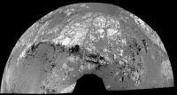
Posted by: serpens Sep 16 2012, 12:25 AM
Sometimes we need to remind ourselves of the scale of this feature.

|
Taking a step back, Ant's superb stitch provides some perspective although I do prefer Viking Mar's color treatment. But my xmas wish list would include a climb to the top of CY from here to check out the nature of the intervening outcrops and hopefully connect a few dots. Are the spherules in this apparent mudstone/siltstone concretions as opposed to the apparent impact generated layer? The distribution does seem to make this possible. If they are is tdemko right that these are attributable to the Burnes formation groundwater event, or does their composition indicate something else?
Posted by: Bill Harris Sep 16 2012, 01:23 AM
Take a look at the color HiRISE image I posted the other day to see what can be seen onthe way up:
http://www.unmannedspaceflight.com/index.php?act=attach&type=post&id=28072
--Bill
Posted by: serpens Sep 16 2012, 02:04 AM
Right. Gotcha. Step back a bit further.

|
The sediment (mudstone or whatever) seems to be localised and follows the contour - pooled against the impact spherule layer?
Oooh - those perpendicular (unloading joints?) are just over there and that old crater just to the NW could maybe perhaps provide a roadcut. Let someone else break an unimportant distance record - I like this place.
Posted by: ngunn Sep 16 2012, 03:03 AM
No, but its colour and lustre I guess makes kieserite a candidate for Bill's 'anomalous' Santa Maria stuff. It could be a marker for the layer where the two different rock chemistries meet. If so, it should be present here at Endeavour too.
Bill - no water or ice at the equator even, say, 10 or 20m down? Do we know this?
Posted by: marsophile Sep 16 2012, 03:46 AM
In looking at your excellent and evocative rendering, I can't help imagining that an impact sheared off the entire top of the Fin formation. Nah, it can't be!
Posted by: Bill Harris Sep 16 2012, 04:32 AM
Let me change that nay to a definite maybe?
--Bill
Posted by: serpens Sep 16 2012, 05:43 AM
Well kieserite is pretty unstable and is a good indicator that there has been no water since exposure from any source. Was any kieserite identified near the smectite signature on CY? Bill's yellow could be kieserite, but then again nontronite is yellowish. From ngunn's link there are polyhydrated sulphates around CY. Anyone have any idea what the hydration state is thought to be and were they Mg or Ca?
But the purplish tinge to Bills anomalous stuff is another thing and could be as simple as a Basaltic breccia precursor, anoxic environment with little if any initial organic carbon. Agatha Christie mysteries are a doddle compared to this place..
Posted by: Oersted Sep 16 2012, 04:06 PM
So it's not just us on this forum who think this is noteworthy.
Definitely hit the big news:
http://cosmiclog.nbcnews.com/_news/2012/09/14/13868790-spheres-spark-new-martian-mystery?lite
Posted by: ngunn Sep 16 2012, 05:08 PM
To continue discussion of the fine-grained 'mud floor':
Almost 6 years ago I proposed this scenario: The Victoria impact fluidises an ice-rich layer buried, say 100-200 metres below the surface. Some of this material drains out from under the crater rim and collects as a temporary lake in the centre of the crater. The crater rim collapses in an irregular pattern into the void created, forming the cliffs and bays we see now.
At the time there was no evidence for an under-layer beneath Victoria, let alone one with the right properties and at the right depth, so unsurprisingly the idea got no support here and we moved on. Now, though, I think this fine-grained unit is a potential candidate for the stuff that fluidised. Dry materials can fluidise when shocked, but it happens a whole lot easier if there's even a little water present. (It also helps with clay-making.)
If the fine-grained unit was patchy to start with (not unreasonable in a "mish-mash of various impactites, ejectites and other residual units") sapping would also have been irregularly distributed, possibly determining the outlines of the capes and bays of Victoria and her similarly endowed twin some kilometres to the south.
Did somebody mention arm-waving?
Posted by: ngunn Sep 16 2012, 07:51 PM
More nice pics of it today: http://qt.exploratorium.edu/mars/opportunity/pancam/2012-09-16/1P401082612EFFBW00P2564L5M1.JPG
http://qt.exploratorium.edu/mars/opportunity/micro_imager/2012-09-16/1M400990845EFFBW00P2955M2M1.JPG
Posted by: udolein Sep 16 2012, 09:37 PM
My version of Whitewater Lake at Sol 3074:

|
http://www.marspages.eu/media/archive4/mer_rover/opportunity/91kirkwood/Sol3074_WhitewaterLake.jpg
Cheers, Udo
Posted by: udolein Sep 16 2012, 09:46 PM
In my opinion the MI of Whitewater Lake must be placed upside down due to the shadows in the upper left side (the sun comes from the right side):

|
http://www.marspages.eu/media/archive4/mer_rover/opportunity/91kirkwood/Sol3071_MI.jpg
Cheers, Udo
Posted by: Stu Sep 16 2012, 10:40 PM
After all these years of being faithful to "McKay" - spotted on the side of Homeplate by Spirit, about a million years ago - I think I have a new favourite Mars rock...

|
Full reverse, Chewie...!!!
Posted by: Ant103 Sep 16 2012, 11:49 PM
Sol 3066 Navcam pan. I love the fact of seeing the rover tracks coming from somewhere *of the crater bottom*.
http://www.db-prods.net/marsroversimages/Opportunity/2012/Sol3066_pano.jpg
Stu! Hay lapa no ya, Stu!
Posted by: craigmcg Sep 17 2012, 12:06 AM
Full reverse, Chewie...!!!
Turtle with a top hat?
Posted by: Jam Butty Sep 17 2012, 12:29 AM
Two pancam images from Sol 3074
A color flicker gif of Stu's rock...

|
And a view of presumably 'Whitewater Lake'...

|
Posted by: Bill Harris Sep 17 2012, 12:37 AM
--Bill
Posted by: climber Sep 17 2012, 12:55 AM
Curiosity like!

Posted by: fredk Sep 17 2012, 01:08 AM
We are starting a "new mission", after all...
Posted by: charborob Sep 17 2012, 01:09 AM
An anaglyph of "Stu's rock":

|
Posted by: RoverDriver Sep 17 2012, 01:56 AM
--Bill
The image reversal depends by the IDD configuration. If the wrist is down the MIs are right side up but if the wrist is up MIs are upside down. I'm not sure if the joint values are reported in the telemetry that is publicly available.
Paolo
Posted by: Bill Harris Sep 17 2012, 03:25 AM
Ah, let me rephrase that and say "many" instead of "all". After I figure the context I typically flip the image to be non-inverted.
Nice area for this stop.
--Bill
Posted by: Don1 Sep 17 2012, 05:58 AM
I really like the idea of an impact orgin for the spherules. Four billion years ago, impact rates would have been very high. Maybe every few million years, a large impactor would have formed a 100 mile class crater and thrown out a shower of spherules. In between impacts, water erosion laid down sediment forming mudrocks.
In the Barberton greenstone belt of South Africa there are several beds of spherules which most believe to have been formed by large impacts 3.2 billion years ago. The beds vary in thickness from a few centimeters to 2 metres. The spherules are described as accretionary lapilli of up to 3mm in diameter, although a few are as much as 10mm in size. They are described as having a concentric appearance with sometimes distinct nucleii, and consist mostly of microquartz chert and sericite. The spherule beds are found in layers of chert. Banded iron formations and shales are also found in the region.
Apart from impact, at least two other theories have been advanced for the formation of the Barberton spherules. One is that they are silcified marine carbonate ooids. The other is that they are formed by volcanic processes followed by hydrothermal alteration. The spherules are believed to be impact produced because of high concentrations of iridium (up to 2700 ppb) and other platinum group elements. They also have a high nickel and chromium content, and chromium isotope ratios have also been interpreted as evidence for impact origin.
I wonder if APXS could detect the iridium?
http://www.nature.com/nature/journal/v485/n7396/images_article/nature11190-f1.2.jpg
Posted by: markril Sep 17 2012, 05:24 PM
Nice, here's a cross-eyed pair:

|
Mark
Posted by: Stu Sep 18 2012, 09:57 AM
Couple of blasts from the past...
Gypsum vein imaged on Sol 3049...

|
...and 456 colour view from Sol 3070...

|
Posted by: belleraphon1 Sep 18 2012, 11:40 AM
Naw... Triceratops..... whose a nice tricie... pats rock
Posted by: Bill Harris Sep 18 2012, 09:42 PM
New MIs of the eroded massive rock with the bluish resistant areas. This may be the most beautiful MI of all.
http://qt.exploratorium.edu/mars/opportunity/micro_imager/2012-09-18/1M401265012EFFBW00P2906M2M1.JPG
The resistant areas are particularly interesting.
--Bill
Posted by: udolein Sep 18 2012, 10:49 PM
result of Sol 3076 brush on Whitewater Lake (must be taken upside down !):

|
http://www.marspages.eu/media/archive4/mer_rover/opportunity/91kirkwood/Sol376_MI.jpg
brush movies:
http://www.marspages.eu/media/archive4/mer_rover/opportunity/91kirkwood/Sol3076_brush1.gif
http://www.marspages.eu/media/archive4/mer_rover/opportunity/91kirkwood/Sol3076_brush2.gif
Cheers, Udo
Posted by: PDP8E Sep 19 2012, 02:46 AM
here is my take on a rock (is there a name?) that was taken on Sol 3070 (L456)

|
edit: 'wolverine?'
Posted by: marsophile Sep 19 2012, 04:14 AM
Isn't that Kirkland (the Fin rock), where the previous MI was done? (The one that is getting all the attention.)
Posted by: Tesheiner Sep 19 2012, 06:54 AM
Kirkwood.
Posted by: Stu Sep 19 2012, 07:53 PM
Slightly "artier" view of Whitewater Lake's recent brushing...

|
Posted by: serpens Sep 19 2012, 11:30 PM
Is this a discrete location where they identified clay on Cape York? Authigenic clay cementing?
Posted by: Bill Harris Sep 20 2012, 02:26 AM
Serpens, this area is "close" to where the phyllosilicates were ID'd. The sensor resolution was fairly coarse and I take any location with grains of salt.
By thinking "authigenic clays", that is a term that covers a lot of territory. Authigenic implies to me that the mineral was formed in-situ by precipitation, recrystallization or metamorphosis. One mechanism could be impact-induced low-temperature hydrothermal activity. We need to see if there are the proper puzzle-pieces to put that picture together. The scenario I favor is that the light-toned material of Whitewater represents an ancient soil horizon where the clays were formed authigenically by weathering of volcanics or impactites which is overlain by the coarse blue-toned "surprise spherules" (of unknown affinity) of Kirkwood, which are impact-related. And they are not even related to the Endeavour impact as they represented the surface or subsurface at the time of the Endeavour impact.
One paper I'd like to read is:
Thomas F. Bristow, and Ralph E. Milliken
http://ccm.geoscienceworld.org/content/59/4/339
and I'm trying to pull strings to get a copy.
At least, this is how the puzzled-pieces are stacking up for me now. As we get more info in, and if my chicken starts to look like it has duck-feet, I'll revise my views...
--Bill
Posted by: CosmicRocker Sep 20 2012, 04:57 AM
I don't know, but it may be a bit premature to be talking about authigenic clay minerals at this point. Once we find and identify the clays, and see them in context, an authigenic origin might make sense.
I've been sort of eyeballing the published CRISM phyllosilicate overlay with respect to Eduardo's route map to estimate Opportunity's location relative to the anomalies. Serpens' question encouraged me to do a quick and dirty overlay of the CRISM anomalies on Tesheiner's route map. This overlay could be off by a few meters here or there, but it will give people an idea of where this interesting outcrop is relative to where CRISM's lower resolution imagery says it should get interesting.
The paper that the CRISM map came from was titled, "Phyllosilicates and sulfates at Endeavour Crater, Meridiani Planum, Mars." The image caption said (in part), "Distribution of Fe/Mg-phyllosilicates (red) and polyhydrated sulfates (cyan) in CRISM spectral parameter maps."

|
edit: I used the only CRISM phyllosilicate map of the area I am aware of. If anyone knows of a better one that's publicly available, please speak up.
Posted by: serpens Sep 20 2012, 05:49 AM
That's the best CRISM map I have seen Cosmic. But if the map is accurate it does beg the question as to why Oppy zigged to avoid the clay bearing area? The ground in that area looks pretty driveable in Navcam so perhaps as Bill implies the clay location isn't all that clearcut.
Bill, the reason I mentioned authigenic is Whitewater seems to be reasonably well cemented mudstone/siltstone and I would have thought a product of CY erosion would be the most likely provenance. The APXS will give a few indications I trust. Those spherical (clasts? concretions? nodules?) in the Whitewater MI are also different.
But if you would indulge me, Steve's description of the spherule layer made me think immediately of my favourite Larsen coffee mug:

|
Posted by: CosmicRocker Sep 20 2012, 05:57 AM
I don't think she zigged to avoid anything. They simply saw some outcrops they couldn't resist.
Posted by: Bill Harris Sep 20 2012, 10:47 AM
Tom, very good overlay of the Route Map and CRISM map. I've been meaning to do that forever.
"Authigenic" in that the clays were produced relatively nearby, as opposed to allogenic where the clays were created in another area and then transported to this site via aeolian or even fluvial processes. We are on the same page, although in different paragraphs.
One puzzle piece that I've had sitting off to the side since the traverse leg along Shoemaker Ridge was the set of orthogonal, light-toned lineations that coincide with the strongest CRISM clay signature. Oppy was closest on Sol-2742-2746, and as you recall, I informally named that area "Secular City". Given that we have since discovered the Homestake-type veins which are low-temperature hydrothermal, this spot should be on our to-do list.
--Bill
Posted by: ngunn Sep 20 2012, 02:17 PM
Isn't Whitewater above Kirkwood in the section (or am I hopelesly confused)?
Posted by: fredk Sep 20 2012, 03:03 PM
I haven't seen a proper map that shows the signatures on CY using the oversampled data - maybe someone else can point us to something public? But I would guess that the Wray etal data that your overlay onto the route map used has been superceeded, and the team is using the better oversampled data to say we're near the orbital signature.
Edit: BTW, from the http://marsrovers.jpl.nasa.gov/mission/status_opportunityAll.html#sol3071
Posted by: ElkGroveDan Sep 20 2012, 04:56 PM
Someone remind me again, how do they determine mineral hydration with the Pancam? Which filter or combination of filters are used?
Posted by: Bill Harris Sep 20 2012, 05:35 PM
--Bill
EDIT:
...and then "uncorrected" it back to reflect the right lithologies.
Unless I'm terminally confused, Whitewater is the "light and fluffy" unit we've seen below the Kirkwood "blue and crunchy" unit Oppy looked at initially. Unless they've gone upslope and set up on one of the light and fluffy's up there.
Let me look and get back...
--b
Posted by: ngunn Sep 20 2012, 05:48 PM
The overall scenario you described does appeal to me (as a non-specialist onlooker). I think there are probably other impactite layers above Whitewater as well. Soils sandwiched between caps and floors of impact origin could be good groundwater traps.
Posted by: udolein Sep 20 2012, 06:27 PM
Why do we stay at Kirkwood these endless sols ?
Why not proceeding a couple of meters uphill into the smectite area as already noticed in CosmicRockers' post #330 ?
http://www.unmannedspaceflight.com/index.php?act=attach&type=post&id=28209
Opportunity drove through that area between sols 2749 and 2751 10 months ago during it's drive to Greeley Haven without any deeper attention to this hopefully interesting area.
Cheers, Udo
Posted by: centsworth_II Sep 20 2012, 07:03 PM
Why not proceeding a couple of meters uphill into the smectite area...
Opportunity drove through that area...
If and when the clays are found, it would be best to find them as part of an intact outcrop, not as a layer of dust or rubble, which is all that might be found in the red blotch areas.
(My non-geologist opinion)
Posted by: ngunn Sep 20 2012, 08:22 PM
Even more confused now. I think you had the rock names the right way round before, but the light-coloured finegrained Whitewater is located above darker, spherule-rich Kirkwood.
CLAY: We may be right on top of it already. Crism only sees the big patches.
Posted by: Don1 Sep 20 2012, 09:34 PM
The rover drove through the clay rich signature last year, on its way to Winterhaven. It was pretty boring, so maybe the clay is mixed into the soil. They did see an outcrop called 'Hooggenoeg', which I think looks a little like the spherule rich outcrops seen from a distance. They also saw 'Sheba' and 'Kirkland lake' boulder field.
http://roadtoendeavour.wordpress.com/2011/10/22/update-3/
http://roadtoendeavour.files.wordpress.com/2011/10/hooggenoeg-2.jpg
Where the rover is right now may very well be a lot more interesting than the clay rich areas. It is definitely a little north of the clay rich area, although the story here is probably tied into the clays in some way.
Posted by: serpens Sep 20 2012, 10:22 PM
They base this on a negative slope from 934 to 1009 nm (I assume with specific slope characteristics for imaged material as hydration shouldn't be the only cause of a 1009 nm absorption feature). All I could locate were abstracts.
http://adsabs.harvard.edu/abs/2011AGUFM.P22A..02R
Posted by: Ondaweb Sep 20 2012, 10:47 PM
Does anybody know why Oppy went north around CY instead of heading south towards the apparently more extensive clay deposits there?
Posted by: Phil Stooke Sep 20 2012, 10:49 PM
Because they had to find a north-facing slope to survive the winter.
Phil
Posted by: fredk Sep 21 2012, 12:21 AM
There were some quotes in the recent http://www.planetary.org/explore/space-topics/space-missions/mer-updates/2012/08-mer-update-opportunity-greets-curiosity.html about the CRISM signatures and our current location.
So it sounds like this is the place to be. As I mentioned above, they may be working with better CRISM data than what we've seen.
Posted by: Ondaweb Sep 21 2012, 01:24 AM
Phil
Ok, thanks Phil.
Posted by: serpens Sep 21 2012, 01:58 AM
"Authigenic" in that the clays were produced relatively nearby, as opposed to allogenic where the clays were created in another area and then transported to this site via aeolian or even fluvial processes. We are on the same page, although in different paragraphs.
--Bill
I was actually thinking residual clay Bill. Clay components (possibly present in the mudstone on deposition or formed in situ) weathering out. One of a multitude of potential scenarios. Some of the discussions within the team must be fascinating.
Posted by: CosmicRocker Sep 21 2012, 03:06 AM
I haven't seen a proper map that shows the signatures on CY using the oversampled data - maybe someone else can point us to something public? ...
A few recent papers have mentioned using the pancam filters to calculate a hydration index as serpens described. See the attached figure from Arvidson et al, "Opportunity Mars Rover mission: Overview and selected results from Purgatory ripple to traverses to Endeavour crater" JGR 2011.

|
Posted by: Bill Harris Sep 21 2012, 04:07 AM
Interesting post-brush Pancams of Whitewater down that afternoon. That "mudstone" appears to be remarkably soft, or at least the weathering rind is. And although the outcrpo looks light- and "reddish-" toned, knock the crust off and it's... bluish. Imagine that, and that will need considerable thought...
Meanwhile, off to figure out where we are on the outcrop and in the section...
--Bill
Posted by: ronald Sep 21 2012, 07:31 AM
Post-brush Pancam image mentioned above:

|
and a quick try on a Pancam/Microimager merge:

|
Posted by: Tesheiner Sep 21 2012, 10:10 AM
This particular spot on the Whitewater Lake outcrop has been labeled Azilda. A quick search gave me the relationship between both:
Whitewater Lake is located in Rayside, Snider and Creighton townships, near the town of Azilda.
Posted by: mhoward Sep 21 2012, 02:32 PM
This one is from way back on sol 3052, before heading west.

|
Posted by: serpens Sep 21 2012, 10:30 PM
--Bill
Well grey more like. Basaltic/glass based sediment weathering to nontronite? Another potential for hydrothermal influence there.
Posted by: Stu Sep 22 2012, 08:17 AM
Oppy and her big sis are obviously locked into a sibling rivalry game of "Anything you can do..."

|
Phobos transit seen by Oppy. The Sun was overexposed but you can see the transit on a reflection just above the glaring Sun...
Posted by: Deimos Sep 22 2012, 01:04 PM
The Sun was horribly stretched, as usual. The exposure was just dandy.
Posted by: Ant103 Sep 22 2012, 02:06 PM
The Whitewater Lake and Kirkwood outcrops panoramic is finaly complete .
http://www.db-prods.net/marsroversimages/opportunity-2012.html#sol3064
Posted by: Pertinax Sep 22 2012, 10:44 PM
I'd figure after 8 years you all would know how how to take a picture of the sun!
-- Pertinax
Posted by: ronald Sep 24 2012, 07:37 PM
Sol 3078 animation - 4x speed

|
Was not able to find this images in the exploratorium folders.
Posted by: fredk Sep 24 2012, 07:47 PM
Thanks for that!
The images are in exploratorium (see Stu's post above), but they are stretched differently so the sun is very hard to make out.
Posted by: jamescanvin Sep 24 2012, 10:39 PM
Here is my version of the mosaic taken at Kirkwood.
http://www.nivnac.co.uk/mer/index.php/b3063
James
Posted by: ngunn Sep 24 2012, 10:56 PM
At the right of that panorama there is a feature that seems to cut right through the strata. It has reddish-(covered) clay-like stuff at its centre and darker rocks either side. Any ideas? A crack filled from above?? or below??
Posted by: Jam Butty Sep 25 2012, 12:17 AM
http://qt.exploratorium.edu/mars/opportunity/micro_imager/2012-09-23/1M400199189EFFBVM5P2956M2M6.JPG
http://qt.exploratorium.edu/mars/opportunity/micro_imager/2012-09-16/1M400198734EFFBVM5P2956M2M1.JPG
Some stereo of the new spherules from sol 3064...
flicker gif

|
and a 30 sec video version thats a bit easier on the eyes...
http://youtu.be/goP-DYlSbs4
Posted by: BrianL Sep 25 2012, 03:30 AM
How odd. Watching that flicker gif, I feel this compulsion to do the time warp. Again.
Brian
Posted by: walfy Sep 25 2012, 05:39 AM
Edit: Replaced the image with a crude stitch of all 4 frames, from sol 3064.

|
Posted by: Zeke4ther Sep 25 2012, 05:44 AM
Brian
A jump to the left! Knees in tight...
Posted by: ronald Sep 25 2012, 07:03 AM
Anyone else wonders what this "fibrous" part might be?

|
Edit: Ahh - only cracks with the right light/shadow combination.
Posted by: walfy Sep 25 2012, 09:13 AM
The blueberries from sol 3064 make for great "piku-piku" super GIFs. I was unable to embed one in this forum, http://www.start3d.com/en/2454477057/0004.
Posted by: Jam Butty Sep 25 2012, 11:35 AM
Nice work walfy,
those piku-piku have come out really well.
Posted by: marsophile Sep 25 2012, 03:15 PM
I get the impression that at least half of the "spherules" are hemispheres, though with the shadows it is difficult to be sure.
Posted by: dburt Sep 25 2012, 09:14 PM
If the hemispheres are broken spherules, they seem (especially in walfy's excellent 3D renderings above) to possess a distinctive radiating fibrous outer rind or shell, although the resolution could be better. This radiating fibrous texture most resembles the spherulitic texture produced by devitrification crystallization (see photo in Antonb's post #218 and the second photo in my post #237 above), but it might also be caused by other rapid radial growth mechanisms. This texture is not, AFAIK, seen in accretionary lapilli produced by impacts or volcanism, inasmuch these grow by random sticking of particles to a nucleus in a condensing turbulent cloud. It also does not resemble any internal structure seen in broken normal blue hematitic blueberries (nor does the central open cavity). The mystery remains.
Posted by: ngunn Sep 25 2012, 10:02 PM
Thanks for the input dburt. But the 'fibres' in ronald's post 367 image are not radial but seem to cross the spherule in approximately parallel directions as if in response to external shear stress after the spherule formed. As to how they formed I notice a nice irony(sorry) here. You say the blueberries formed in mid-air and these spherules formed in situ on the ground whereas if I understand things right most folks seem to be tending the opposite way in both cases.
Posted by: serpens Sep 25 2012, 11:08 PM
.....
Edit: Ahh - only cracks with the right light/shadow combination.
The question is why the cracks, which to my overactive imagination seem to have been infiltrated resulting in veining?
ngunn may be right in that the cracks were due to (compaction?) stresses. Or it could be dburt's devitrification crystallization. But I would throw another hypothesis into the mix being rapid quenching of hot glass spherules causing the fracturing. That would of course require that the spherules dropped into water. I remember a paper a few years ago identifying this effect in an impact spherule layer - in South Africa I think. There do seem to be clasts included in some spherules which would point towards glass rich lapilli.
This hypothesis would of course require surface water and since the Miyamoto ejecta would have been hundreds of metres thick here the spherule layer would have to postdate that event. Also this would pretty much rule out the Endeavour impact. So a reasonably thin layer of spherules from another impact could have fallen into surface water overlaying the Miyampto ejecta blanket (the large channels to the south that cut the Miyamoto ejecta do make such a real possibility). This would then make the spherule layer part of the Endeavour uplift rim.
Posted by: atomoid Sep 26 2012, 12:16 AM
the fact that so may are semispheres tends to suggest radial crystalization is making them vulnerable to temperature shock induced erosion, otherwise we'd see less halving across the diameters and more random breakage, perhaps a common terran geological observation, no?
Posted by: marsophile Sep 26 2012, 12:21 AM

|
A higher resolution view of the fibrous example, (in parallel stereo).
Posted by: dburt Sep 26 2012, 04:22 AM
Many seem to be confusing these so-called "fibers" (cross-cutting fractures, most likely; I agree with serpens on this) with the far more subtle radial growth textures (that is, super-fine fibrous crystals, at the limit of resolution of the best photos, radiating from the center) seen in the erosion-resistant outer shell or rind to which I was referring above. You have to look carefully at the images to see them. Again, refer to the photos in above posts 218 and 237 (lower photo) to see what I am comparing them to.
Posted by: Bill Harris Sep 26 2012, 10:18 PM
My initial impression of the "spherules of unknown affinity" was that they were zeolite, particularly by way of the fibrous radial structure seen in some of the split. I'm not a hard-rock type and this was from ig-met pet courses in school many years ago. I'll always remember the appearance of the hand specimens we had in the lab collection. I recalled that zeolites are secondary minerals created by the interaction of groundwater with volcanic rocks. I've since read up on the zeolite family and it is an interesting mineral.
As I said, I'm a soft-rock guy and I'll need to do considerable research on this or just listen to my betters...
--Bill
Posted by: serpens Sep 26 2012, 11:22 PM
You mean formed as a devitrification product? The spherulites seem to be restricted to a reasonably thin layer and glass rich lapilli/devitrification don't seem to be mutually exclusive events particularly if the matrix is also glass.
Posted by: dburt Sep 26 2012, 11:43 PM
Zeolites are a good suggestion. My colleague Steve Ruff has argued that they should be widespread on Mars. They commonly form, owing to the action of groundwater, in vesicles (gas cavities or bubbles) in cooling basaltic lava, and in this type of occurrence they are beloved of mineral collectors the world over. They require a more alkaline environment to form than the neutral environment of clay minerals or the acid environment of iron sulfates, owing to their high alkali content.
However, most are distinctly white or light-colored, and although some are fibrous or needle-like (acicular), they only loosely fill the cavities in which they are found. They typically do not constitute the resistant shells. I would therefore be somewhat surprised if the apparently micro-fibrous dark rinds of the hollow spherules in question were made up of zeolite minerals, although on Mars I would hesitate to exclude any possibility. This is all off the top of my head, of course. I'm giving a test and leading a field trip tomorrow, and am running more than a little late.
Posted by: Bill Harris Sep 27 2012, 01:56 AM
Yep, I keep hopping around on this and arm-waving. They might be devitrification byproducts, the probably aren't hematitic BlueBerries and they might even be something else. We won't know until we learn the mineralogy of this unit, and we won't learn that until The Big Paper comes out at LPSC.
I'm still leaning towards weathering and alteration byproducts on the pre-Endeavour land surface. This will certainly tell us much about Martian environmental conditions at that time.
"Zeolites" can have a very broad range of characteristics, much like the phyllosilicate family. I found a very interesting paper tonight on this subject:
Bethany L. Ehlmann, John F. Mustard, Gregg A. Swayze, Roger N. Clark,
Janice L. Bishop, Francois Poulet, David J. Des Marais, Leah H. Roach,
Ralph E. Milliken, James J. Wray, Olivier Barnouin-Jha, and Scott L. Murchie
Received 23 January 2009; revised 8 May 2009; accepted 11 June 2009; published 23 October 2009
http://www.planetary.brown.edu/pdfs/3932.pdf
--Bill
Posted by: atomoid Sep 27 2012, 02:23 AM
|
|
A higher resolution view of the fibrous example, (in parallel stereo).
Fascinating stuff... what really gets me in http://www.unmannedspaceflight.com/index.php?act=attach&type=post&id=28313 its dramatically apparent how the veined ('fibrous') section protrudes from the rock almost like planes of a desert rose suggesting it crystalized inside of, or more likely is an erosion resistant remnant of an eroded spherule interior.
note that no other spherules (afaik) exhibit this, suggesting (to my non-geologist eye) the veining formed through mineralization of fractures.
an odd puzzle is the fractures seem to occur in only this small area, not across a larger section as would be expected from slumpage or dessication, unless they did exist but were erased from erosion and this is all thats left
Posted by: ronald Sep 27 2012, 03:24 PM
Pancam Sol 3084:

|

|

|
left is L3-L5-L6 (bit screwed up colours
), middle the usual L2-L5-L7, left a try on combining L7-R1 One more - L3-L5-L6 this time:
http://dl.dropbox.com/u/5875127/mer/1P401968488EFFBW00P2569L356.JPG
Posted by: jamescanvin Sep 27 2012, 09:58 PM
Whitewater Lake (used all 6 L filters for better colour and to reduce artefacts)
http://www.nivnac.co.uk/mer/index.php/b3071
Posted by: ronald Sep 28 2012, 02:21 PM
Sol 3085:

|
Posted by: xflare Sep 28 2012, 09:39 PM
Get used to the view folks, we're going to be here a while.
http://www.jpl.nasa.gov/news/news.php?release=2012-306
One working hypothesis, out of several, is that the new-found spherules are also concretions but with a different composition. Others include that they may be accretionary lapilli formed in volcanic ash eruptions, impact spherules formed in impact events, or devitrification spherules resulting from formation of crystals from formerly melted material. There are other possibilities, too.
That's a subtle hint if I ever saw one.
Posted by: Bill Harris Sep 29 2012, 12:46 AM
Ah so. Matijevic Hill is the "official" name of the location that I had informally called "Shoemaker Bench". This will prove to be a great stop.
--Bill
Posted by: Stu Sep 29 2012, 10:20 AM
Whitewater Lake RAT hole...

|
Posted by: Tesheiner Sep 29 2012, 12:09 PM
Looks soft as butter, isn't it?
Posted by: Stu Sep 29 2012, 12:57 PM
I can't believe it's not butter...
Posted by: climber Sep 29 2012, 02:12 PM
This is important information I'd say! Soft as clay would be even nicer.
Posted by: elakdawalla Sep 29 2012, 02:30 PM
Tesheiner just set 'em up for you to knock 'em down
The softness of these rocks is crazy. I've been imagining Opportunity's wheels crunching like boots on rock but I'll bet that when there's gravel underfoot it doesn't crunch so much as grind; gravel between your foot and the rock might gouge its way in. On a field trip to west Texas while I was in college I encountered a rock made of bentonite -- it was able to form cliffs in the desert but walk on it and your boots gouged right in. It was weird stuff. (http://aneyefortexas.wordpress.com/2012/03/22/colors-of-bentonite/.)
Posted by: Eutectic Sep 29 2012, 08:17 PM
My college geology field class drove past a bentonite mine in Wyoming -- the stuff was scooped right out of the hillside into rail cars. Bentonite has many uses, including incorporation into candy bars, which in this case could lead to a whole new meaning for Mars Bars. Here's a little more about bentonite -- note the rock-water interaction:
http://www.rawell.co.uk/products_technical_information/what_is_bentonite.php
Bentonite is a natural inert clay that was formed from volcanic activity during the Cretaceous period approximately 100 million years ago. Long periods of repeated eruptions laid ash into the sea where it was chemically altered and consolidated into layers of clay. Over time the ground folded and lifted thrusting up the clay and silt to form the Black Hills and Big Horn mountains of Wyoming, USA. The term bentonite is generally applied to colloidal clay associated with the Cretaceous Benton shale found near Fort Benton. Bentonite mining first began in 1888.
The first recorded use of the mineral known as the clay of a thousand uses was for making cosmetics, it then became used as a foundry sand bond in the 1920s followed soon after as a drilling mud. The uses have continued to expand into the fields of bleaching clay, animal feeds, pharmaceuticals, colloidal fillers for paints and inks, ceramics and in the motor industry for spark plugs and catalytic converters.
Posted by: Bill Harris Sep 29 2012, 09:39 PM
I wouldn't make too much of it being bentonite. I've seen kaolinite in east Alabama, chalk/marl in south Alabama, loess along the Missippi and bentonite in the Big Bend of Texas that all look similar. We can see/say that it is a soft, fine-grained, amorphous material of uncertain composition and origin.
Yeah, more arm-waving and hopping back-and-forth. Hot on the trail of a hypothesis...
--Bill
Posted by: elakdawalla Sep 29 2012, 10:54 PM
I wasn't suggesting Opportunity's rock is made of bentonite; I was just musing on how different the soft rock seems from what one normally thinks of as "rock."
Posted by: serpens Sep 29 2012, 11:45 PM
Well it looks like mudstone/siltstone/clay - roll on the APXS results. I still think that this is a sedimentary construct resulting from the weathering of the Shoemaker deposit. Given that this weathered material would have encompassed igneous rocks and impact glass couldn't we expect a mixture of clay types, for example montmorillonite-chlorite, potentially layered or veined (crack fill)?
Posted by: climber Sep 30 2012, 12:49 AM
Do you remember the time when we didn't know at which side of the planet to look at since two rovers were discovering new things? This time's back
Posted by: Bill Harris Sep 30 2012, 12:10 PM
--Bill
Posted by: ngunn Sep 30 2012, 01:02 PM
Ultimate origin(s) of the material may be too much to expect. We have to work backward from the way it looks now and how it fits into its context. I'd like to try out a rather simplistic hypothesis, namely that it is the remains of a continuous and widespread bed of sediment that formed in situ at some time between the Miyamoto and Endeavour impacts. How would it have responded to the latter? Given its softness and fine texture plus the possibility that it held water, I think it would have squidged and flowed all over the place as the Endeavour rim settled, destroying evidence of its original bedding and occupying cracks in the more resistant rocks. To a first approximation that seems to fit the scene we're looking at.
Posted by: Ant103 Sep 30 2012, 02:11 PM
Yes, and what's better : there is TWO generations of rover on Mars. Working. We're living blissed times.
Posted by: serpens Sep 30 2012, 11:25 PM
With all hypotheses I think we need to keep the big picture context in mind. The original impact would possibly have been large enough to create a complex crater. In support of this, the series of interior ridges within the rim to the east could be the remnants of marginal collapse zones. If so, then if CY is indeed part of the outer uplift rim the original surface would have been subject to surface spalling as well as horrendous heat, overpressure and wind scour. I dont think a sedimentary deposit would survive in the way you suggest and I feel it more likely to be due to post impact weathering.
Posted by: ngunn Oct 1 2012, 12:49 AM
We're not looking at the original surface of the interior of the crater but something that has eroded outward a bit from there. What do you think would have happened to previously existing sedimentary layers a little distance out? At least we can say that layering is preserved here - the new spherule layer is still in place and it must have predated the crater. So I think you're wrong (until more evidence turns up). But thanks for responding to my suggestion!
Posted by: serpens Oct 1 2012, 01:18 PM
Not necessarily, that depends on the final determination of the nature of the spherule layer and currently all is conjecture. Emily raised a good point that the crater would have eroded back to some degree, but the hills to the south seem to be remnants of the rim and CY is on the same circumference. So it was likely once internal to the crater rim, which would have been uplift covered by ejecta/suevite.
Posted by: ngunn Oct 1 2012, 05:41 PM
I really want to understand what you're saying, but this bit defeats me:
Anyhow on the 'conjecture' point I totally agree - there are many very different plausible scenarios given the huge depth of geologic time here.
Posted by: Stu Oct 2 2012, 08:20 AM
Enhanced view of latest "Whitewater Lake" RAT activity...

|
Posted by: ElkGroveDan Oct 2 2012, 02:02 PM
That's kind of artistic looking.
Posted by: Bill Harris Oct 2 2012, 02:44 PM
Without stratigraphy, geology would have nothing to sit upon; and without geology, geography would have nothing to sit upon. And so it goes...
--Bill
Posted by: belleraphon1 Oct 3 2012, 10:48 AM
A.J. S. Rayl monthly MER update now available at The Planetary Society Blog...
Mars Exploration Rovers Update: Opportunity Finds Thrill of Newberries on Matijevic Hill
http://www.planetary.org/explore/space-topics/space-missions/mer-updates/2012/09-mer-update-opportunity-finds-newberries.html
Have not had time to read it yet....
Craig
Posted by: fredk Oct 3 2012, 02:24 PM
A bit of a bump on 3090 to continue working on Whitewater Lake by the looks of it:
http://qt.exploratorium.edu/mars/opportunity/forward_hazcam/2012-10-03/1F402508029EFFBW19P1214R0M1.JPG?sol3090
Posted by: MarkG Oct 3 2012, 04:37 PM
"Mars Exploration Rovers Update: Opportunity Finds Thrill of Newberries on Matijevic Hill"
...a nice convoluted rock and roll pun....
Powered by Invision Power Board (http://www.invisionboard.com)
© Invision Power Services (http://www.invisionpower.com)