Printable Version of Topic
Click here to view this topic in its original format
Unmanned Spaceflight.com _ Earth Observations _ Hughes STORMSAT (1976)
Posted by: gndonald Jan 12 2014, 12:52 AM
With the restoration of the NTRS a few interesting 'almosts' have come back online including this dedicated 'nasty weather' satellite intented to improve coverage of mesoscale events like tornados, squall lines and large scale thunderstorm complexes.
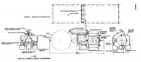
The report indicates that this spacecraft started out as a Delta launched vehicle but was being studied for a shuttle launch had it actually flown.
QUOTE
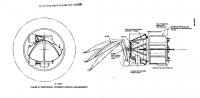
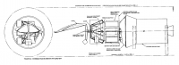
The STORMSAT spacecraft and its primary sensors, the Advanced Atmospheric Sounding and Imaging Radiometer (AASIR) and Microwave Atmospheric Sounding Radiometer (MASR), will be used to provide the data base to enhance understanding of mesoscale weather phenomena, The primary data provided by STORMSAT will be visible images, infrared images,infrared temperature and humidity sounding, and microwave temperature and humidity sounding. These data will be processed into visible and infrared pictures, vertical temperature and humidity profiles, and possibly precipitation estimates. These data are currently being provided by a combination of polar orbiting and geostationary satellites, but not with the time and/or space resolution needed for mesoscale observation.
See:
http://ntrs.nasa.gov/archive/nasa/casi.ntrs.nasa.gov/19780013777_1978013777.pdf
|
|
|
Powered by Invision Power Board (http://www.invisionboard.com)
© Invision Power Services (http://www.invisionpower.com)