Instrument commissioning phase, Beginning final approach to the comet |

  |
Instrument commissioning phase, Beginning final approach to the comet |
 Aug 5 2014, 02:13 PM Aug 5 2014, 02:13 PM
Post
#211
|
||
|
Solar System Cartographer  Group: Members Posts: 10151 Joined: 5-April 05 From: Canada Member No.: 227 |
It's premature to decide that. We will have to see how the Rosetta team decide to do it. But the ends are not poles if the shape model rotation movie is showing us the correct rotation. In fact one pole appears to be in the deepest part of the neck.
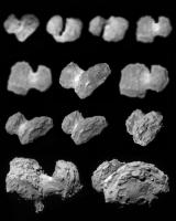
This is a composite of the approach images.
Phil -------------------- ... because the Solar System ain't gonna map itself.
Also to be found posting similar content on https://mastodon.social/@PhilStooke Maps for download (free PD: https://upload.wikimedia.org/wikipedia/comm...Cartography.pdf NOTE: everything created by me which I post on UMSF is considered to be in the public domain (NOT CC, public domain) |
|
 |
 
|
|
|
Aug 5 2014, 02:28 PM
Post
#212
|
|
|
Member Group: Members Posts: 540 Joined: 17-November 05 From: Oklahoma Member No.: 557 |
QUOTE (jasedm @ Aug 4 2014, 04:35 PM)  ... I nominate the smaller component as 'Klim' (less letters in the name) and the larger as 'Svetlana'.  It would help if we could find a full body portrait of the discoverers standing side by side. So far, all I can find on the web is for Svetlana Ivanova in this interview. QUOTE (Phil Stooke @ Aug 5 2014, 08:13 AM) In fact one pole appears to be in the deepest part of the neck. Yes, and where the terrain appear smoother than most of the comet. Slow movement, fairly smooth surface, dramatic views... this would be my bet for a landing area. Unless the soil is too loose to harpoon. Or there is too much outgassing activity in the area to be safe. |
|
|
|
|
Aug 5 2014, 03:33 PM
Post
#213
|
|
|
Solar System Cartographer Group: Members Posts: 10151 Joined: 5-April 05 From: Canada Member No.: 227 |
But that deep 'canyon' has a limited view of the sun - for power - and of Rosetta - for communications - so it's a bad location for a lander.
Phil -------------------- ... because the Solar System ain't gonna map itself.
Also to be found posting similar content on https://mastodon.social/@PhilStooke Maps for download (free PD: https://upload.wikimedia.org/wikipedia/comm...Cartography.pdf NOTE: everything created by me which I post on UMSF is considered to be in the public domain (NOT CC, public domain) |
|
|
|
|
Aug 5 2014, 03:51 PM
Post
#214
|
|
|
Member Group: Members Posts: 540 Joined: 17-November 05 From: Oklahoma Member No.: 557 |
Are you sure about that? I'm not saying you're wrong (and maybe you've been talking to the right people). Just that if the spin axis is tilted toward the the sun (more or less) during the landing in November, you could pick an area that is in almost constant sunlight at one of the poles. Even if the crevasse was deep enough to cause some shadowing over part of the rotation, it might not be any worse than landing on any other part of the comet that is moving in and out of sunlight. And if the main spacecraft could station keep above the pole, I would think it would have an advantage in nearly constant communication.
It would help a lot to know just where the spin axis is pointing, but I don't know if the coordinates have been released. Note: Yes, there were ground based estimates in 2012 that put the axis at RA = 40° ± 10°, Dec = 70° ± 10°, with a solar tilt of 40 degrees. But I'm saying I haven't heard whether the results from Rosetta's direct observations have been released. |
|
|
|
|
Aug 5 2014, 05:23 PM
Post
#215
|
||
 Member Group: Members Posts: 796 Joined: 27-February 08 From: Heart of Europe Member No.: 4057 |
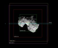
FOVs for all Rosetta's long range instruments (except OSIRIS WAC) from distance 100 km.
OSIRIS WAC has ~5× bigger FOV (side length) than OSIRIS NAC, so it's too big for this picture.
Attached thumbnail(s)
-------------------- |
|
|
|
|
|
|
Aug 5 2014, 05:51 PM
Post
#216
|
|
|
Solar System Cartographer Group: Members Posts: 10151 Joined: 5-April 05 From: Canada Member No.: 227 |
Not sure, just an educated guess. We'll see what the team have to say about it later.
Phil -------------------- ... because the Solar System ain't gonna map itself.
Also to be found posting similar content on https://mastodon.social/@PhilStooke Maps for download (free PD: https://upload.wikimedia.org/wikipedia/comm...Cartography.pdf NOTE: everything created by me which I post on UMSF is considered to be in the public domain (NOT CC, public domain) |
|
|
|
|
Aug 5 2014, 06:46 PM
Post
#217
|
|
 Member Group: Members Posts: 655 Joined: 22-January 06 Member No.: 655 |
QUOTE (machi @ Aug 5 2014, 06:23 PM) FOVs for all Rosetta's long range instruments (except OSIRIS WAC) from distance 100 km. OSIRIS WAC has ~5× bigger FOV (side length) than OSIRIS NAC, so it's too big for this picture. Brilliant Machi, and very useful - thanks! |
|
|
|
|
Aug 5 2014, 11:24 PM
Post
#218
|
|
|
Founder Group: Chairman Posts: 14432 Joined: 8-February 04 Member No.: 1 |
And for those of us familiar with Cassini or MER/MSL sized sensors - good news...OSIRIS cameras are 2k x 2k (i.e. 4 megapixels)
Doug |
|
|
|
|
Aug 6 2014, 12:16 AM
Post
#219
|
||
|
Member Group: Members Posts: 808 Joined: 10-October 06 From: Maynard Mass USA Member No.: 1241 |
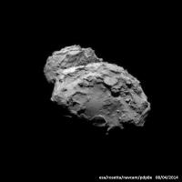
Here is the Aug 4th 2014 NAVCAM
upsampled, deconvolved, and reoriented for sunlight from above...
-------------------- CLA CLL
|
|
|
|
|
|
|
Aug 6 2014, 12:55 AM
Post
#220
|
|
|
Merciless Robot Group: Admin Posts: 8783 Joined: 8-December 05 From: Los Angeles Member No.: 602 |
Okay, THIS shot reminds me of two lumps of uncooked fudge batter side by side.
-------------------- A few will take this knowledge and use this power of a dream realized as a force for change, an impetus for further discovery to make less ancient dreams real.
|
|
|
|
|
Aug 6 2014, 02:53 AM
Post
#221
|
||
|
Member Group: Members Posts: 808 Joined: 10-October 06 From: Maynard Mass USA Member No.: 1241 |
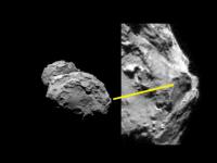
This is from the Aug 4th Navcam
This looks like a feature that is raised and could spew comet 'stuff'
-------------------- CLA CLL
|
|
|
|
|
|
|
Aug 6 2014, 03:20 AM
Post
#222
|
|
 Senior Member Group: Members Posts: 1419 Joined: 26-July 08 Member No.: 4270 |
Any idea what these raised plateaus are? Water-poor regions that evaporated at slower rates while their water-rich surroundings evaporated faster?
-------------------- -- Hungry4info (Sirius_Alpha)
|
|
|
|
|
Aug 6 2014, 03:36 AM
Post
#223
|
|
 Administrator Group: Admin Posts: 5172 Joined: 4-August 05 From: Pasadena, CA, USA, Earth Member No.: 454 |
I think there have been a lot of ad-hoc explanations for different features on comets that are hard to validate. By orbiting a comet Rosetta will give us the first chance to take a look at these things from many sides, over time, to help us make some sense of these features. Getting more excited about this mission every day.
-------------------- My website - My Patreon - @elakdawalla on Twitter - Please support unmannedspaceflight.com by donating here.
|
|
|
|
|
Aug 6 2014, 05:15 AM
Post
#224
|
||
 Member Group: Members Posts: 238 Joined: 15-January 13 Member No.: 6842 |
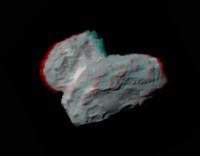
QUOTE (machi @ Aug 4 2014, 04:00 AM) Results of my stereo experiments. 3D images are based on best published OSIRIS and NavCam images. One image in stereo pair is original OSIRIS image, second image is combined NavCam/OSIRIS synthetic image. Credit for original images: ESA / Rosetta / NavCam / MPS for OSIRIS Team MPS / UPD / LAM / IAA / SSO / INTA / UPM / DASP / IDA. Fantastic work! If you don't mind, here's a version of your anaglyph with stereo separation centered approximately on the comet's "neck". The larger half of the comet should now appear raised above the computer screen.
(The reason for this adjustment is that I like it when the red and cyan components of an anaglyph aren't removed too far from each other, effectively being easier to "combine" in your brain) -------------------- Curiosity rover panoramas: http://www.facebook.com/CuriosityRoverPanoramas
My Photosynth panoramas: http://photosynth.net/userprofilepage.aspx...;content=Synths |
|
|
|
|
|
|
Aug 6 2014, 09:18 AM
Post
#225
|
|
 Senior Member Group: Admin Posts: 3108 Joined: 21-December 05 From: Canberra, Australia Member No.: 615 |
Ongoing live coverage of Rosetta's arrival at Comet 67P C-G.
Streaming:http://rosetta.esa.int/ and on Twitter: https://twitter.com/ESA_Rosetta Not long now 
|
|
|
|
|

|
Lo-Fi Version | Time is now: 26th April 2024 - 02:35 AM |
|
RULES AND GUIDELINES Please read the Forum Rules and Guidelines before posting. IMAGE COPYRIGHT |
OPINIONS AND MODERATION Opinions expressed on UnmannedSpaceflight.com are those of the individual posters and do not necessarily reflect the opinions of UnmannedSpaceflight.com or The Planetary Society. The all-volunteer UnmannedSpaceflight.com moderation team is wholly independent of The Planetary Society. The Planetary Society has no influence over decisions made by the UnmannedSpaceflight.com moderators. |
SUPPORT THE FORUM Unmannedspaceflight.com is funded by the Planetary Society. Please consider supporting our work and many other projects by donating to the Society or becoming a member. |
|