Printable Version of Topic
Click here to view this topic in its original format
Unmanned Spaceflight.com _ MRO 2005 _ HiPOD
Posted by: jamescanvin Nov 30 2006, 07:09 AM
OK folks. I have to admit I'm starting to feel a little overwhelmed in HiRISE images already, and I know the tap hasn't even been turned fully on yet! There is just so much territory to be looked at.
To help us all see just a little bit more I propose that we start a 'Picture of the day' type thing (not necessarily one per day, the more the merrier  ) of HiRISE screen sized sub-images. Not necessarily the most amazing bits, but a bit random, I find myself quite drawn to the less obvious bits that no one may have seen yet.
I'm going to use the same filenames as the original images appended with approximate pixel coordinates of the sub-image so that it can be found easily in the original.
James
Posted by: jamescanvin Nov 30 2006, 07:12 AM
Here's your first.
|
Posted by: edstrick Nov 30 2006, 09:22 AM
Lot of FLR's lying around there....
(Funny Looking Rocks)
----> wow <----
Posted by: remcook Nov 30 2006, 01:58 PM
"Lot of FLR's lying around there..."
...and they seem to flock together as well. I think we need a massive swearing box in this thread!
Posted by: jamescanvin Nov 30 2006, 11:15 PM
I've changed my mind - separate discussion thread would be a pain - threads merged.
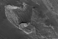
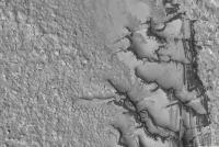
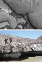
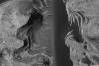
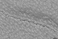
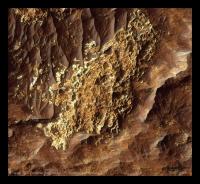
Not far from the first image you get to the big feature of the image, a steep scarp up onto the North polar ice cap. I see that a nice dry stone wall has been build around the bottom.
|
Posted by: ustrax Nov 30 2006, 11:35 PM

Not far from the first image you get to the big feature of the image, a steep scarp up onto the North polar ice cap. I see that a nice dry stone wall has been build around the bottom.
I'm a fan of the http://hiroc.lpl.arizona.edu/images/PSP/PSP_001370_2505/
Posted by: ElkGroveDan Nov 30 2006, 11:54 PM
No kidding. Speaking of "gullies". If someone wants to break this one open that center part with the gullies would be nice to see at full res.
Posted by: Sunspot Dec 1 2006, 12:45 AM
has this HiVIEW viewing software been put on hold?
Posted by: tuvas Dec 1 2006, 01:50 AM
No, it's just a tad bit harder than we expected... As I understand in it's current form it works as most JP2 clients work, but the full JPIP capability is still forthcoming.
Posted by: jamescanvin Dec 1 2006, 03:26 AM
Here is a tiny bit of that HUGE Eberswalde image.
|
Posted by: jamescanvin Dec 2 2006, 04:42 AM
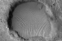
For Ustrax.
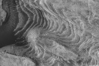
Enigmatic features on the Enigmatic Ice Mound...
|
btw, Did I mention anyone is free to add there own pics here?
 I'd love to see what the rest of you are spotting.
Posted by: ElkGroveDan Dec 2 2006, 03:47 PM
Thanks James. There's a roughly stitched seem in that image that I realigned (below), although artifacts along the seem are still visible.
I wonder if anyone is going to claim those gullies are caused by flowing sand, high atop the ice mound.
|
Posted by: centsworth_II Dec 2 2006, 05:38 PM
To me, what at first look like gullies, or large rivules, look like something else up close: Undercut ledges at the edge of domed mounds (of ice?). Very small rivules do seem to be coming out from under the ledges.
Posted by: centsworth_II Dec 2 2006, 05:53 PM
I imagine a rover would see something like this (minus the liquid water of course... and the people):
|
From http://www.nus.edu.sg/everest/gallery/g2/index_5.htm
Posted by: lyford Dec 2 2006, 06:58 PM
What about something like Vasquez Rocks poking up through the Enigmatic Ice Mound?
|
Ground View - with Gorn:

|
Posted by: climber Dec 2 2006, 09:32 PM
|
|
From http://www.nus.edu.sg/everest/gallery/g2/index_5.htm
and minus the streack on the rigth and minus the blue sky and minus ....BTW, centsworth_II, WHY did you post this picture?
 and don't challenge me on Everest's pictures
Posted by: JunqueMan Dec 2 2006, 11:21 PM
Hi, I'm new here to the forum, been lurking for awhile, and thought I'd chime in on this thread. I've always been extremely interested in Mars since I was a kid,
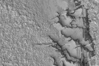
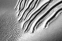
Here's an intriging closeup of PSP_001440_1255_RED which is described as "Channels on Dunes in Russell Crater". I find the channels very curious. The hypothesis by the MOC team definitely sounds plausible.
To a non-scientist, like myself, they remind me of when you roll a large snowball down a snow covered hill. The snowball leaves a trail, pretty much like those pictured, till it disintegrates. I wonder if they could have been caused somewhat in the same manner, but by clumps of Martian soil rolling downhill? 
I followed the naming suggestion, however, I'm not sure how close the pixel coordinates are. 
|
Posted by: ElkGroveDan Dec 3 2006, 03:49 AM
Ah my old stomping grounds. I grew up about 30 minutes from there.
Posted by: antipode Dec 3 2006, 05:57 AM
Speaking of naming, it seems to me that as new metre scale features come into view with MRO, we are going to need a new set of naming conventions. Probably there are too many of these strange levy-edged gullies to name INDIVIDUALLY, but they seem to occur in clumps, or 'fields' - what might we be tempted, following other Martian naming conventions, too call these suckers?
P
Posted by: centsworth_II Dec 3 2006, 02:13 PM
Because I thought it was a good representation of what the MRO
image was showing us.... Ice mounds, undercut along the edges.
That's how I see it anyway. Here I show how the pink and yellow
backpackers and an observing blue-decked rover might look in
the MRO image. You can see the perspective from which the rover
would be looking into the undercut edge of the ice mound.
|
Posted by: climber Dec 3 2006, 08:34 PM
image was showing us.... Ice mounds, undercut along the edges.
That's how I see it anyway. Here I show how the pink and yellow
backpackers and an observing blue-decked rover might look in
the MRO image. You can see the perspective from which the rover
would be looking into the undercut edge of the ice mound.
I've got the point and by puting the two pictures together I guess this is pretty accurate. (I was just joking because you say it is what it'll look like... minus this, and this and this...
)
Posted by: jamescanvin Dec 4 2006, 05:47 AM
Welcome, and thanks for chiming in JunqueMan.
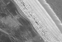
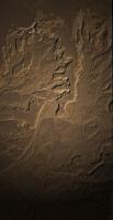
Here's one for you - terrain doesn't get a lot more featureless than this, just a few tiny, metre sized craters.

|
Posted by: Stu Dec 4 2006, 02:44 PM
Good grief!! These new MRO pics are amazing!!! Somehow I managed to stay offline while I was away - quite an effort, I can tell you, with an internet cafe right in the hotel foyer!!! - but seeing these new pics I;m glad I did, I'd have done nothing else!
If the Swear Box takes Euros I reckon I can half fill it just from the expletives I let out seeing those gullies for the first time...!!! 
Posted by: Nirgal Dec 5 2006, 10:28 PM
How true, Stu
and what makes all this especially fascinating is the fact that not only there are many incredibly-high-quality new mars images to explore but that at the same time, due to the sheer image dimensions, each one of us can explore a whole little new world WITHIN each of the imgaes themselves, scrolling accross those alien landscapes, almost as if we all could fly our own little mars exploration airplane above the surface
fascinating, incredible, beautiful, ... a childhood dream coming true
Thanks again for all of NASA/JPL/MSSS/HiRISE Team and all who made this possible and for the courage to
provide all this online & near-real time to the world-wide public !
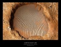
Posted by: jamescanvin Dec 6 2006, 01:52 AM
I think you need to fix your credit again Nirgal.
Next,
Dust lake, north of Viking 1.
Kind of reminds me of Clarke's http://en.wikipedia.org/wiki/A_Fall_of_Moondust
|
James
Posted by: Nirgal Dec 6 2006, 04:56 PM
Nice find.
I wonder how deep the dust layer is there (reminds me also of the "dust fall" observed recently by
mars express ...)
why ? my thanks obviously goes to anyone involved with the MRO spacecraft and instruments, including MSSS
for the Context Camera (CTX)
Posted by: jamescanvin Dec 7 2006, 01:48 AM
Ah OK Nirgal, I got confused by a strange list of credits.
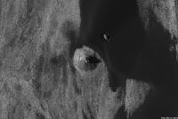
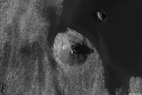
First from the new batch
Weird, just weird.
|
From: http://hiroc.lpl.arizona.edu//images/PSP/PSP_001410_2210/
Posted by: kenny Dec 7 2006, 09:52 AM
Ustrax says: I'm a fan of the "enigmatic ice mound"...
http://hiroc.lpl.arizona.edu/images/PSP/PSP_001370_2505/
This is actually the startling frozen crater lake seen in color by Mars Express at 70N 103E in 2005:
http://www.esa.int/SPECIALS/Mars_Express/SEMGKA808BE_0.html
Kenny
Posted by: tty Dec 7 2006, 06:56 PM
No crater lake this - it's 200 meters high!
tty
Posted by: jamescanvin Dec 7 2006, 11:06 PM
Thanks Kenny, I hadn't made that connection.
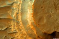
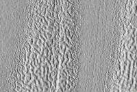
Here are three more from the staggering Becquerel crater image.
|
|
|
Posted by: JunqueMan Dec 9 2006, 04:19 AM
Here's one for you - terrain doesn't get a lot more featureless than this, just a few tiny, metre sized craters.
Thanks.
I'm truly amazed at the number of varied landscapes that have been photographed so far, and this being just the start of MRO's mission. When I was young, the best pictures of Mars were from the Mariner missions. I'm simply blown away with what the HiRISE camera is capable of doing.

Posted by: Stu Dec 10 2006, 09:58 PM
Colourised and enhanced version of the now much-loved "delta" in Eberswalde...
|
... just 'cos I felt like it!
Posted by: Shaka Dec 10 2006, 11:04 PM
Stuey, you and Dilo should work up the first tourist brochures for Fly-Drive Martian Holidays.
Posted by: Nirgal Dec 11 2006, 07:24 PM
... just 'cos I felt like it!
Very nice & atmospheric image, Stu .. i like the subtle color gradients
Those MRO images are a dream to colorize (can't wait for the full 14-bit data release which should offer
even more dynamic range)
Here are some attempts at hand-coloring (thanks also to jamescanvin who discovered the detail views
within the large images)
The Beqcuerel-Crater-"Beacon Tower" at the shore of the sand sea:
|
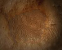
Posted by: Nirgal Dec 11 2006, 07:26 PM
And the beautiful "sand lake" north of the Viking landing site (The Greyish color of the sand is inspired by
similar appearance of the dark/grey patch of sand at Eldorado)
|
Posted by: ustrax Dec 11 2006, 08:03 PM
similar appearance of the dark/grey patch of sand at Eldorado)
Nirgal...You have done it!
In my oppinion those are your best images so far.
Posted by: mhoward Dec 11 2006, 08:17 PM
similar appearance of the dark/grey patch of sand at Eldorado)
Astronishing! Hard to say how accurate [the colorization] is, but deeply thought-provoking.
Posted by: Stu Dec 11 2006, 09:23 PM
Outstanding! I had a go at that one myself but having seen yours no way I'm putting it up!

Posted by: ustrax Dec 11 2006, 09:46 PM
Hard to say?!!!...I'll crown Nirgal as the author of one of the most astonishing images of our neighbour planet so far!...And this wasn't so hard to say...
Posted by: mhoward Dec 11 2006, 10:12 PM
Oh I agree... Although I think MRO had something to do with authoring the original image, the enhancement and colorization is probably the best I've ever seen.
Posted by: climber Dec 11 2006, 10:21 PM
Nirgal, your Beacon-Tower is just x%zygrrk¤¤ (sorry I miss words).
I'm sure somebody can tell its height since we have this nice shadow.
Thanks & thanks
Posted by: Nirgal Dec 12 2006, 12:29 AM
thank you all very much for all the nice words
I'm glad you like the images so much ...
However this would not be possible without MRO providing such unbelievably high quality raw material !
I can hardly describe the excitement it causes whenever a new batch of images arrives: then It's just as
if one could start one's own helicopter tour accros giga-pixel-wide breathtaking areas of our neighbour planet, discovering details and taking color photographs of the scenery through the window :-)
... and the best is surely still to come with much more MRO imagery and HiView / 14-bit quality...
exciting times ahead !
Posted by: Stu Dec 12 2006, 03:30 PM
Alternative view of nirgal's "dust lake crater"... can't get the colours as nice or as accurate as yours nirgal (and thanks for the tips, much appreciated! They're what made me decide to post my effort after all... ) so I'm going for a more dynamic "My Mars" look...

|
Posted by: lyford Dec 12 2006, 04:10 PM
Just want to add to the Nirgal Love Fest that in addition to the awesome colorizing, I really like the borders and titles as well - a good frame for a great picture! I think I know what my first print will be from our new Phaser 6120n...
Posted by: babakm Dec 12 2006, 05:22 PM
If JamesCanvin's image is at full resolution (~25cm/pixel), the ~100 pixel length of the shadow + ~41 degree angle of the sun -> height of ~22 meters. Not as impressive as I initially thought, but still as tall as a nine-story building.
Posted by: dilo Dec 12 2006, 08:34 PM
Imagine what would see a rover (or an astronaut) close to this obelisc...

Nirgal, you made two really breathtaking colorizations!
Stu, I like your too but I notice some kind of vignetting effect or a fill-in flash-like center illumination which is not natural, IMO...
Posted by: Stu Dec 12 2006, 08:41 PM
Not natural at all, I was going for abstract
I just liked the effect... just trying something different, imagining what the view would be like if the dunefields "caught the Sun" briefly and reflected it back...
Posted by: jamescanvin Dec 12 2006, 09:33 PM
No it's not. Here is the full res version - double the size so it's ~44m tall.
|
Oh and on refinding the mount I realized that my pixel coordinates in the filenames, taken from the 'center' values in Expressview are screen pixels and are therefore wrong if not zoomed in all the way. So some of the coordinates given so far will be wrong.
James
Posted by: climber Dec 12 2006, 09:49 PM
OK, that will still be my first climb when I'll get there
Posted by: Stu Dec 13 2006, 02:00 PM
This one's for ustrax... again, not trying to be 100% colour accurate, but going for something a little more abstract and, well, attractive for the sake of it.
|
Posted by: ustrax Dec 13 2006, 02:11 PM
You are far too kind...
I just love the artistic freedom you guys inprint in scientific data...
Posted by: climber Dec 13 2006, 02:32 PM
Hope our artistic freedom will not make some Martians angry
Posted by: Stu Dec 13 2006, 02:39 PM
Hey, as soon as they evolve past the microbial stage, they're welcome to come to and take as many pics of Earth and colourise them as they want to!
Posted by: rogelio Dec 13 2006, 04:04 PM
I know this request will be blasphemy for some, but...
I for one would appreciate a 10 or 25 meter scale bar somewhere on each HiRise image. The human scale of planetscapes and moonscapes is what has always attracted me to unmanned space flight; I love to imagine myself at the scene. Could I step over those polygonal cracks at Becquerel? Standing in a trough in the dust lake, could I see over the next dune crest? Problem is, I have to carefully read the caption or get out the calculator to figure out the scale how much more user-friendly to have a scale bar in each image. Instant gratification!
Posted by: AndyG Dec 13 2006, 04:17 PM
I can imagine it...Earth's sky taken by their robotic landers being tweaked to caramel since blue is just...well too alien for some back on Mars.
Andy
Posted by: ngunn Dec 13 2006, 04:17 PM
I'll second that. Exactly what's been on my mind since they started coming down - but you had the courage to post it first!
Posted by: Nirgal Dec 13 2006, 06:16 PM
I like this one, Stu (which frame is it from?)
your colorizations are getting better and better ... nicely balanced "true-colorish" hue palette,
yet not too monochromatic/casted
... just the overall brightness could be improved (it's a bit too dark)
Posted by: Stu Dec 13 2006, 11:16 PM
Thanks Nirgal, I really appreciate the constructive comments and support. I finally feel like I'm getting somewhere now... I hear what you're saying about that image being a bit dark, maybe that's a glimpse into my character...!
Posted by: Floyd Dec 14 2006, 12:29 AM
Stu, I like dark for a medatative image. Think Mark Rothko!

|
Posted by: jamescanvin Dec 14 2006, 12:34 AM
Abysses!  (With scale )
|
|
http://hiroc.lpl.arizona.edu/images/PSP/PSP_001513_2650/
James
Posted by: jamescanvin Dec 14 2006, 12:56 AM
And here's a big one. (note this is at 50cm/pixel)

|
Posted by: Steve Dec 14 2006, 03:33 AM
(With scale )James
They're not abysses, they're http://en.wikipedia.org/wiki/Qanat. Now we know where to look for the water.

Percival Lowell was right about canals, only they were underground.
Steve
Posted by: CosmicRocker Dec 14 2006, 06:41 AM
I guess they are more romantic terms for those so inclined. I thought they were lowly "pits," but how spectacular they are. I must say that the fountain of HiRise and other MRO instrument data recently released has brought me to my knees in tears, so perhaps some artistic license is in order.
I have been trying for a couple of weeks to post some of my favorite crops from these amazing images, but every time I open a new one I find myself getting lost in a never-never land of disbelief. It is all so real, yet unreal. Polar Layered Deposits, alluvial fans, gullies... How about the mega-breccia? That one really freaked me out. Who is waiting for the MRO data from that "light-toned" gully deposit? I so wanted to point out some special places in all of them. I guess I'll settle for posting one tonight.
This highlighted color image from the pole captured my attention. It was kind of like finding an agate in the rough. It is seriously reduced in resolution, and minus a scale bar, but this is one to get in full res.

|
Posted by: rogelio Dec 14 2006, 01:12 PM
MANY thanks for the scale bars, jamescanvin!
Now I can see at a glance that the small "ganats" are the size of a backyard inflatable swimming pool, and the big "ganat" is the size of a city block.
Wasn't that easy?
Posted by: Ames Dec 14 2006, 01:48 PM
Percival Lowell was right about canals, only they were underground.
Steve
"ICEBERG!, right ahead!"
April 14 1912
Could these be icebergs rising above the CO2?
Nick
Posted by: CosmicRocker Dec 16 2006, 06:55 AM
That is an interesting thought, Ames. I don't know a lot about the polar layered deposits, but I thought they were composed of layers of water ice, CO2 ice, and aeolian sediments. Your comment caused me to look up the density of CO2 ice, which is reported to range between ~ 1.3 and 1.6 gm/cm^3. So, water ice should be buoyant in CO2 ice.
We know that glaciers of water ice flow at earthly temperatures, but I would assume that flow is slower in current Martian temperatures. I don't know if CO2 ice can flow, but since it is held together by Van der Waals force, it probably can.
I hope some folks who know more about these layered polar deposits comment. There is a lot of thickening and thinning observed in the polar layers recently imaged by HiRise. Much of that appears to be due to depositional/erosional processes, but some of it resembles the density induced flows seen in buried salt layers on Earth, which flow more slowly than ice. I haven't found any http://www.google.com/search?q=define%3Adiapir, but this concept is intriguing.
Posted by: Steve Dec 16 2006, 01:51 PM
Another model would be that these are glacial caves and crevasses. (A more serious variant of my original qanat suggestion).
The HiRISE caption doesn't say whether the ice they've imaged is CO2 or Water ice. If the latter, could we have the kind of water flow that creates glacial caves on earth? (subterranean heating coupled with salts producing an anti-freeze mechanism).
On a stream-of-consciousness tangent, is there any research on the physical properties of frozen brines of various kinds of salts? At Martian temperatures, we could see all kinds of intriguing solids that are never solid in ordinary terrestrial circumstances.
Steve
Posted by: CosmicRocker Dec 17 2006, 03:46 AM
No doubt the pits and pit-chains are something like terrestrial glacial caves and crevasses. Something that was once there is now gone. Coincidentally, the main JPL site is http://www.jpl.nasa.gov/news/features.cfm?feature=1243 about some studies of moulins in Greenland glaciers.
I just wanted to clear up some potential confusion I may have caused with my earlier post. I was talking about some of the thickening and thinning of the layers seen in the HiRise image of the polar layered deposits, not the pits. Some of it looks flow induced to me.
I tried earlier to find some physical property information about CO2 and H2O ice, but didn't find much that I could relate to shear or tensile strength. Surely it is out there somewhere. As for frozen brines, I don't know.
Posted by: Nix Dec 17 2006, 11:20 PM
Tumbling boulders;
http://www.awalkonmars.com/PSP_001415_1875_RED_crop100per.jpg
also in color from HiRise website;
http://hiroc.lpl.arizona.edu/images/PSP/PSP_001415_1875/
Nico
Posted by: CosmicRocker Dec 18 2006, 04:51 AM
Those are awesome, Nico. Thanks for posting that, and for the crop.
Posted by: Ant103 Dec 18 2006, 12:31 PM
In the first time, I think that was car tracks on the sand! Very strange how geomatric are these features.
Posted by: Stu Dec 18 2006, 01:11 PM
In the first time, I think that was car tracks on the sand! Very strange how geomatric are these features.Oh god, Hoagland is just going to LOVE these hi-res images... he was bad enough when things were blurry, now we can see all this fine detail he'll be telling people on Enterprise Mission (oh, and by the way, does anyone else hate the fact that he's hijacked the name of the most famous, most noble starship ever? It really, really grates on me!!!!
 Sorry, rant over!) that every tumbled boulder track was made by a golden-sailed martian sandship hissing across the plains....
Posted by: ngunn Dec 18 2006, 01:34 PM
I notice that some go straight but with bounces while others go in curves. I wonder if this is because most of them are flattish slabs? The straight bouncy tracks could be due to slabs rolling face-over-face while the curves are made by slabs rolling wheel-fashion on their edges.
Posted by: Nix Dec 18 2006, 01:58 PM
Something to think about ngunn...though the local geometry might hold a lot of 'variables'.
Nico
Posted by: ngunn Dec 18 2006, 02:31 PM
Nico
Sure. It could be that the straight ones are more like cubes or irregular spheres while the curves could in principle be produced by tapered spindle shapes, but I do think wheel-like behaviour is the most likely explanation for the curves because the curves seem to tighten up as the objects lose momentum - exactly like a wheel, or coin.
Posted by: climber Dec 18 2006, 09:09 PM
I would associate the shape of the curve with the original speed when the rocks hit the terrain after falling down from "above". You can notice that the "strait one" jumped back in the air several time untill it finaly made a regular path. The "one that curve" never jumped back in the air. I've seen this several time in the mountains (I mean here on Earth
) that rocks tend to finish they fall bending their trajectory as they loose speed. That could be an explanation, it seams logical to me but, as you says they might have other variables.
Posted by: Nix Dec 23 2006, 05:27 PM
I'd like to share this crop from http://hiroc.lpl.arizona.edu/images/PSP/PSP_001468_1535/, Primary Science Phase, release #3.
A rather large portion of the actual image but still reasonably within reach for those of you on dial-up.
(~30 Mbytes)
I find the geological complexity of this image just utterly mind-blowing! But maybe that's because I'm no geologist
http://www.awalkonmars.com/PSP_001468_1535_RED_crop100per.jpg
Right-click 'save target as' for download.
Nico
Posted by: Marz Dec 23 2006, 06:38 PM
Nico
Wow, that is amazing! Interesting how in the top portion of the image, the cracks are polygonal, but in the center, the cracks become square. What happened in the lower right portion of the image to scramble up the terrain so much?
Posted by: dilo Dec 23 2006, 06:59 PM
Thanks Nico! I hope more will come from Hi-cropper volunteers like you
Meanwhile, I made this "wallpaper zoom" with some interesting features in original scale, on the right:
|
Posted by: Myran Dec 24 2006, 01:39 AM
I wonder too, of the image linked by Nix I can see some parts that looks a bit like something I am familiar with from Earth perspective, bedrock that have been cracked and jumbled around and then fused together again so the layers can be vertical in one place and horizontal a few hundred meters away. This in the bottom right corner, it is similar to what I have seen many times in my neck of the woods.
But going left (west?) to about middle bottom we see large pieces of bedrock that have cracked and slided sideways where one piece even have created one overhang. Is it pressure from layers above that now are gone, sliding on wet, icy or muddy bedrock, or perhaps even one ancient Mars quake that caused this?
To rephrase what they say on the Hirise operation center website, this is one area that cries out for exploration by a mobile rover.
Posted by: Stu Dec 24 2006, 06:25 AM
On behalf of all the many people who, like myself, can't download or wander around the huge hi-res images, can I just say how much I appreciate people taking the time and trouble to crop these monster images and post their "highlights" here? I don't feel like I'm missing out so much now. Thank you!
Posted by: MarsIsImportant Dec 24 2006, 10:43 AM
I'm using IRFANVIEW.
I have a major problem with trying to load JP2 files much larger than 100 Mbytes into the program. Is it a problem with my program, or do I just need to adjust the buffer size? I don't know what size the buffer needs to be for these monster files. I'm not familiar enough with the program to solve the problem very easily by myself.
Smaller JP2 files work well with the program. Larger ones just crash it. Help!
Posted by: MarsIsImportant Dec 24 2006, 10:49 AM
Could RAM memory by a limiting factor too? But it cannot be the only problem, because I have 500 Mbytes of RAM for my machine. I noticed that some files are over 600 Mbytes and expand to over 1.2 gigs. ...still need help.
Thanks.
Posted by: Adam Dec 24 2006, 12:51 PM
I have a major problem with trying to load JP2 files much larger than 100 Mbytes into the program. Is it a problem with my program, or do I just need to adjust the buffer size? I don't know what size the buffer needs to be for these monster files. I'm not familiar enough with the program to solve the problem very easily by myself.
Smaller JP2 files work well with the program. Larger ones just crash it. Help!
I have the same problem, but it usually works if I try a second time, I have 2GB RAM.
Posted by: Julius Dec 24 2006, 04:02 PM
Cant wait to see some CRISM data on the Holden crater layers!
Posted by: CosmicRocker Dec 25 2006, 06:30 AM
Posted by: nprev Dec 25 2006, 08:14 PM
Meanwhile, I made this "wallpaper zoom" with some interesting features in original scale, on the right:
Thanks, Dilo!
Wow. Wow. Wow. The bottom right closeup with those rectangular sedimentary blocks completely blows my mind...
Posted by: Myran Dec 26 2006, 09:37 PM
JP2 images, like JPG images are compressed. Lets say I open one 100KB image compressed in the JPG format, it will take up 2000KB of system memory on average.
Now we have these monster images that are 100MB from the start, and I dont know the compression ratio. But from the example above they could very well decompress into something that takes up 20 times more of the computers memory. This is the reason I gave up on these extremely huge files, since I knew my computer isnt up for the task. I guess adjusting the buffer could help, but if there isnt a lot of diskspace available the image might not open properly at all.
Posted by: tuvas Dec 26 2006, 09:42 PM
Now we have these monster images that are 100MB from the start, and I dont know the compression ratio. But from the example above they could very well decompress into something that takes up 20 times more of the computers memory. This is the reason I gave up on these extremely huge files, since I knew my computer isnt up for the task. I guess adjusting the buffer could help, but if there isnt a lot of diskspace available the image might not open properly at all.
The released images from JPEG 2000 are all compressed losslessly. Most JPG images have some quality of loss associated with them. The result is that JPEG 2000 uncompressed images are on the order of 3 times larger than the compressed. If one day HiRISE released some images compressed somewhat, with minimal distortion the image can be much more compressed.
Also, this doesn't take into account the large black areas where no image exists. And the images are never fully decompressed to begin with. The way JPEG 2000 decoding works allows for only a decompression of a small segment of the image.
Posted by: Stu Dec 27 2006, 03:27 PM
Is today a "Picture Release" day or is there a delay 'cos of Christmas? (Heading out for work in 5 mins, so if it IS a piccie day I guess you'll all have been drooling over them already when I get home tonight... looking forward to the highlights! )
Posted by: CosmicRocker Dec 27 2006, 10:07 PM
The http://hiroc.lpl.arizona.edu/images/PSP/PSP_001666_1530/ image from Release 4 is one of my favorites. I cropped an area containing some of the larger fragments, and added a scale bar and an overlay of Eagle Crater with lander (~22 meters) for another sense of scale.
As I was looking at the larger image, I noticed that my brain would sometimes invert the topography, creating a completely different impression of the geology. Most of you are probably familiar with the effect. The description from the HiRise site tells us that the illumination is coming from the north, so it is clear that these large breccia clasts are softer than the surrounding matrix, and have eroded to become depressions rather than elevated blocks.
I thought it might be fun to hear how others initially "see" the topography in this area, so I made the attachment containing two images. The one on top has the original orientation, and the bottom image has been flipped vertically.
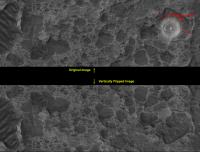
|
edit: I was led into this exercise because http://hiroc.lpl.arizona.edu/images/PSP/PSP_001666_1530/PSP_001666_1530_Holden.jpg is flipped or rotated, thus creating a misleading impression.
Posted by: edstrick Dec 28 2006, 09:46 AM
A psychological trick to de-invert "flipped" topography in space images (craters that look like domes, etc) is to orient the image with the real direction of illumination from the top, and to actually position a light source "above" the picture if just orienting it so light is coming from "above" doesn't work.
Posted by: CosmicRocker Dec 29 2006, 08:28 AM
Hmm, a psychological trick? Are you suggesting a real light source above my monitor? I never would have considered that. I have looked at that image so many times that it changes every time I blink.
Posted by: Bob Shaw Dec 29 2006, 10:53 AM
That's exactly how to do it. Point your finger at the screen, make a shadow, and POW! those Martian Domed Cities become, er, craters!
Bob Shaw
Posted by: edstrick Dec 29 2006, 12:51 PM
"Are you suggesting a real light source above my monitor? "
Exactly. It's a desperation last trick for images that won't de-invert. Usually, just orienting the pic so the pic's illumination is coming from above -- as seen by the viewer -- works, but some pics are "recalcitrant"
Posted by: CosmicRocker Dec 30 2006, 07:11 AM
I really tried to make that work, using various light sources at different positions. But I don't see how I would create the shadow of my finger on my bright screen, short of using a blinding light. It sounds like a good idea, though.
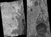
In keeping with the theme of illusions, here is something different. When I first saw http://hiroc.lpl.arizona.edu/images/PSP/PSP_001427_1820/, I knew instantly how it needed to be "enhanced." The f@ce and pyr@mids of the Cydonia region are nothing compared to this place. Kick me, if I am bad, but I thought we made allowances for artistic impression here.
The detail that HiRise is able to capture is amazing. I've named this image, "Mars...Land of Change."
|
Posted by: Pando Dec 30 2006, 06:49 PM
What helps is the way your finger (or try any other object) is illuminated from the light above, and the shadow is not necessarily needed. Expecting a light source from the top is wired to our brains, naturally.
Posted by: djellison Dec 30 2006, 06:54 PM
I've never struggled with this, once I read "illumination from the left" - I'm fine...BUT
I've NEVER been able to watch the Apollo 11 landing and see 'craters' on the surface, it's always been domes....it really annoys me
Doug
Posted by: RedSky Dec 30 2006, 09:22 PM
In keeping with the theme of illusions, here is something different. When I first saw http://hiroc.lpl.arizona.edu/images/PSP/PSP_001427_1820/, I knew instantly how it needed to be "enhanced."
The f@ce and pyr@mids of the Cydonia region are nothing compared to this place. Kick me, if I am bad, but I thought we made allowances for artistic impression here.The detail that HiRise is able to capture is amazing. I've named this image, "Mars...Land of Change."
|
|
Nice joke, there CR. I almost didn't notice the Jefferson Nickel until I saw the words "trust" and "liberty" on the crater rim. Oh, and the FDR dime makes for nice "change" also...
Posted by: Nirgal Jan 1 2007, 05:03 PM
First of all, A Happy New Year to all of you
Let me share the latest finding of my "HiRISE Mars Sightseeing Flights": a colorized crop of the "Ius Chasma" image of the PSP5 release http://hiroc.lpl.arizona.edu/images/PSP/PSP_001364_1715/
Included is a 50-meter scale symbolized as the shadow of an "imaginary" passenger-jet, just for a better "sense of scale" of the
scenery ...
|
(usual disclaimer: the synthetic colors are based on "real-color" palettes and guesses about
probable surface composition (i.e. "blackish" dark basaltic sand dunes with light colored, more reddisch/yellowish exposed rocks etc.)
Posted by: Bob Shaw Jan 1 2007, 10:27 PM
Let me share the latest finding of my "HiRISE Mars Sightseeing Flights": a colorized crop of the "Ius Chasma" image of the PSP5 releaseIncluded is a 50-meter scale symbolized as the shadow of an "imaginary" passenger-jet, just for a better "sense of scale" of the scenery ...
Ahaa! Caught you! You're obviously posting in the style of that last image post - down in the corner, it's a Jefferson Airplane...
Bob Shaw
Posted by: CosmicRocker Jan 17 2007, 05:23 AM
I wasn't sure which thread would be best to post this in, since it is an anaglyph made from the color image of Eberswalde delta from release 1 and a grayscale image from release 8. I like the concept of a HiPOD thread, so here it is.
This full-scale anaglyph is from an area north of the oxbow anaglyph of release 8. It has a lot of relief and a nice view of the polygonal blocks eroding from these sedimentary layers. The scale bar is 100 pixels/25 meters long, and 2 pixels/50 centimeters wide.
|
Edit: I just wanted to note that this is a progressive jpeg, to give a false sense of instant gratification to those of you on dialup, like myself. A low resolution version builds relatively quickly, and the details fill in painfully slower.
Posted by: dilo Jan 17 2007, 06:17 AM
Great works, Tom and Bernhard!
Posted by: ustrax Jan 17 2007, 09:03 AM
I subscribe that!
Nirgal...How do you do that?!
You know I'm saving them all...
In the end I'll print them all and keep your work as a treasure...
Posted by: CosmicRocker Jan 22 2007, 06:05 AM
Thanks for your kind comments, Marco and ustrax.
I've been experimenting with color anaglyphs where only one image from the stereo pair is in color. It seems that it works much better when the colored image is for the right eye. The Eberswalde pair fortunately matched that criterion. I now find myself wishing that the rovers' Pancams had the color filters on the right side.
Anyway, that exercise started me wondering if there were any other HiRise stereo pairs where one of them was in color...and that led me to collect a listing of released HiRise images, and to learn how to decipher the HiRise image names. I haven't yet found any other stereo pairs that would make interesting false-color anaglyphs, but I thought the image catalog I collected might be useful to others.
I am posting an Excel spreadsheet that contains all of the images and their descriptions. It is easily sortable, and you can use the auto-filter buttons to filter the data fields in many convenient ways. I have also included links to the images, and a field indicating if color or stereo is available. (If I missed any, perhaps someone will let me know.) Thanks to the HiBlog, I learned that the file names are composed from the Mission Phase, Orbit #, and Target Code. I could not use that information to identify the location of the images, but I was able to use the Target Code to calculate the latitude of the center of each image.  MRO_HiRise_Image_Catalog1_posted.xls ( 152.5K )
: 356
MRO_HiRise_Image_Catalog1_posted.xls ( 152.5K )
: 356
Posted by: Bob Shaw Jan 22 2007, 08:50 AM
People's eye/brain imaging system exhibits 'handedness'. Normally, one eye is dominant over the other, so it may well be that *you* see anaglyphs in a better way when you tickle the right-hand neurones - but other folk might do better the other way around! I don't know what the relative numbers are for right/left visual preference, but there's every chance that there is an overall bias towards one side or the other. Perhaps the instructions for looking at anaglyphs should include a suggestion that, if all else fails, the image should be flipped right-left.
Good work, though, I really enjoyed flying over the delta!
Bob Shaw
Posted by: CosmicRocker Jan 22 2007, 10:44 PM
I'm sure you're correct about that. On occasions when I had to look at reversed anaglyphs with the glasses flipped I have difficulty seeing depth at first. My brain definitely wants the red filter on the left and cyan on the right. In the case of the half-color anaglyph I was hypothesizing that with the color image coming through the cyan filter, twice as much color information (blue and green) can pass. Whereas with color on the left, only red can pass. That may be an oversimplified way to look at it.
On a different subject, I realized that many more people could use the HiRise image list I made if I posted it in html rather than as an Excel file. This will not have the functionality of the spreadsheet I posted ealier, but at least it is a listing of all the images available so far, with ancillary information and links to the image page. MRO_HiRise_Image_Catalog1_posted.htm ( 166.4K )
: 429
MRO_HiRise_Image_Catalog1_posted.htm ( 166.4K )
: 429
Powered by Invision Power Board (http://www.invisionboard.com)
© Invision Power Services (http://www.invisionpower.com)