Satellite Topography, new global maps |

 Unmanned Spaceflight.com > Outer Solar System > Saturn > Cassini Huygens > Cassini general discussion and science results
  |
Satellite Topography, new global maps |
 Nov 30 2010, 09:24 PM Nov 30 2010, 09:24 PM
Post
#1
|
||
 Member  Group: Members Posts: 207 Joined: 6-March 07 From: houston, texas Member No.: 1828 |
hey fellas,
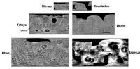
Just posted a new blog showing the topographic maps of Saturn's icy moons that I showed back at DPS in Pasadena last month. Ive been on extensive travel since then and just now getting back to some backlogged projects, including posting these new maps. They are global topography of the 6 larger icy moons (excluding Titan). There are some interesting comparisons and details to be seen here. Hope yall enjoy. A more detailed report will be published this spring. paul http://stereomoons.blogspot.com/ Here is a greatly reduced version to wet your appetite. Note that all are scaled to +/- 5 km topographic range.
Attached thumbnail(s)
-------------------- Dr. Paul Schenk, Lunar and Planetary Institute, Houston TX
http://stereomoons.blogspot.com; http://www.youtube.com/galsat400; http://www.lpi.usra.edu/science/schenk/ |
|
 |
 
|
|
|
Nov 30 2010, 10:15 PM
Post
#2
|
|
|
Senior Member Group: Members Posts: 3516 Joined: 4-November 05 From: North Wales Member No.: 542 |
Beautiful! One immediately obvious fact is that the equatorial ridge of Iapetus continues all the way round, with only minor gaps and no deviations from geometric regularity.
|
|
|
|
|
Nov 30 2010, 10:18 PM
Post
#3
|
|
|
Founder Group: Chairman Posts: 14431 Joined: 8-February 04 Member No.: 1 |
Awesome - can't wait to add these as normal maps to Eyes on the Solar System

|
|
|
|
|
Jan 13 2011, 03:21 AM
Post
#4
|
||
|
Member Group: Members Posts: 207 Joined: 6-March 07 From: houston, texas Member No.: 1828 |
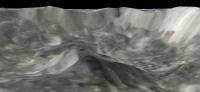
finally processed the February Mimas data and here is a nice view of the interior of Herschel.
http://stereomoons.blogspot.com/2011/01/mi...cture-show.html
Attached thumbnail(s)
-------------------- Dr. Paul Schenk, Lunar and Planetary Institute, Houston TX
http://stereomoons.blogspot.com; http://www.youtube.com/galsat400; http://www.lpi.usra.edu/science/schenk/ |
|
|
|
|
|
|
Jan 15 2011, 01:41 AM
Post
#5
|
|
 IMG to PNG GOD Group: Moderator Posts: 2250 Joined: 19-February 04 From: Near fire and ice Member No.: 38 |
Looks awesome and needless to say a huge improvement over anything created using data obtained prior to February 2010.
As a matter of curiosity, is the DEM based on stereo imagery only or combined stereo and shape from shading? |
|
|
|
|
Jan 15 2011, 03:58 PM
Post
#6
|
|
 Senior Member Group: Members Posts: 1627 Joined: 5-March 05 From: Boulder, CO Member No.: 184 |
QUOTE (ngunn @ Nov 30 2010, 10:15 PM)  Beautiful! One immediately obvious fact is that the equatorial ridge of Iapetus continues all the way round, with only minor gaps and no deviations from geometric regularity. Very nice color & topo maps on Paul's blog. It seems to me though that the ridge is a bit subdued around 0-90E longitude areas. Still it's nice to see some hints of it in these areas where I hadn't noticed it much before. -------------------- Steve [ my home page and planetary maps page ]
|
|
|
|
|
Jan 15 2011, 06:31 PM
Post
#7
|
|
|
Member Group: Members Posts: 903 Joined: 30-January 05 Member No.: 162 |
How about that, the 'off ramps' are in the right location on the ridge! (the highest spot)
An inclined outer 'brim' of the ring system would seem to be evident, therefore. Inclined ring elements were noted at Neptune and are attributed to the effect of Triton's inclination, would this be a converse type of effect at Iapetus, the primary (Saturn) essentially being 'felt' as inclined (although it is actually Iapetus at ~15 degrees that is inclined) and creating the inclined 'brim'? I note in the blog an invitation to computer model some rings. I hope if the sims are carried out they can incorporate Dr. Burns ideas about ring warping. I'm itching to watch this animation, having been born about 4 billion years too late to see it in real life . . . 
|
|
|
|
|
Jan 16 2011, 03:04 AM
Post
#8
|
|
|
Member Group: Members Posts: 890 Joined: 18-November 08 Member No.: 4489 |
I think the dr is using all stereo ,so far all i have been able to do with sfs is artistic only .
the maps ARE nice . I like them . |
|
|
|
|
Jan 20 2011, 10:05 PM
Post
#9
|
|
|
Member Group: Members Posts: 207 Joined: 6-March 07 From: houston, texas Member No.: 1828 |
QUOTE (JohnVV @ Jan 15 2011, 09:04 PM) I think the dr is using all stereo ,so far all i have been able to do with sfs is artistic only . the maps ARE nice . I like them . Mimas map so far only stereo. will add SFS soon but the Herschel areas are with higher sun elevations making SFS very unreliable in those data. -------------------- Dr. Paul Schenk, Lunar and Planetary Institute, Houston TX
http://stereomoons.blogspot.com; http://www.youtube.com/galsat400; http://www.lpi.usra.edu/science/schenk/ |
|
|
|
|
Jan 25 2011, 10:05 PM
Post
#10
|
|
|
IMG to PNG GOD Group: Moderator Posts: 2250 Joined: 19-February 04 From: Near fire and ice Member No.: 38 |
QUOTE (DrShank @ Jan 20 2011, 10:05 PM) Mimas map so far only stereo. will add SFS soon but the Herschel areas are with higher sun elevations making SFS very unreliable in those data. And distinguishing between albedo variations and brightness variations caused by topography must present some problems as well. Are these images rendered using true vertical relief or exaggerated relief? |
|
|
|
|
May 31 2013, 08:29 PM
Post
#11
|
|
|
Member Group: Members Posts: 241 Joined: 16-May 06 From: Geneva, Switzerland Member No.: 773 |
"Thanks to close-up images of a 500-mile-long (800-kilometer-long) mountain on the moon from NASA's Cassini spacecraft, scientists have found more evidence for the idea that Dione was likely active in the past. It could still be active now."
http://www.jpl.nasa.gov/news/news.php?release=2013-178 |
|
|
|
|

|
Lo-Fi Version | Time is now: 23rd April 2024 - 07:30 AM |
|
RULES AND GUIDELINES Please read the Forum Rules and Guidelines before posting. IMAGE COPYRIGHT |
OPINIONS AND MODERATION Opinions expressed on UnmannedSpaceflight.com are those of the individual posters and do not necessarily reflect the opinions of UnmannedSpaceflight.com or The Planetary Society. The all-volunteer UnmannedSpaceflight.com moderation team is wholly independent of The Planetary Society. The Planetary Society has no influence over decisions made by the UnmannedSpaceflight.com moderators. |
SUPPORT THE FORUM Unmannedspaceflight.com is funded by the Planetary Society. Please consider supporting our work and many other projects by donating to the Society or becoming a member. |
|