Distant vistas, Endeavour, Iazu, and beyond |

  |
Distant vistas, Endeavour, Iazu, and beyond |
 Feb 28 2010, 01:23 AM Feb 28 2010, 01:23 AM
Post
#136
|
|
 Member  Group: Members Posts: 236 Joined: 5-June 08 From: Udon Thani Member No.: 4185 |
Mathematically it's possible to calculate the distance from some 'mountain' top by measuring the angle it is protruding above the horizon (even it the foot of the hill is still invisible below the horizon), or vice versa you can calculate the height of the object if you know the exact distance to it.
Theoretically it seems to me it would be possible to do this same calculation on Mars, we can calculate the angle by measuring the number of pixels a hill is protruding above the horizon (total camera viewing angle is known as well as total pixel height of the image). It would surely be only a very rough result, but it might be fun to see how it works out and compares to orbital measurements. Two problems are that you need to take into account the refraction of light (well known on earth, but on Mars?) and you need to be certain that the horizon you see is indeed the horizon and not some landmark or hill, so the flatter the landscape the better it works. I don't know whether anyone has ever tried to do this? |
 |
 
|
|
Feb 28 2010, 03:56 AM
Post
#137
|
|
 Senior Member Group: Members Posts: 4246 Joined: 17-January 05 Member No.: 152 |
Yeah, I did this a while ago for the east rim of Endeavour in this post.
We can now see quite a bit more, and I estimate we can now see close to 200 metres of vertical extent of the east rim. Refraction would make the hills look shorter than they really are, so 200 metres would be a lower limit. But I doubt refraction matters too much here since the atmosphere is so thin. We can't see all of the rim yet, so there's got to be more height to the rim hills than we can see yet. So again 200 metres is a lower limit, but probably not by much. |
|
|
|
|
Feb 28 2010, 04:52 AM
Post
#138
|
|
|
Member Group: Members Posts: 890 Joined: 18-November 08 Member No.: 4489 |
QUOTE I have a question for the image processing whiz kids here. I've filtered the region above the horizon line with the standard 2d median in photoshop, which does a good job of removing the compression noise but smears the mountain peaks and valleys. Since the brightness of the horizon profile increases (roughly) monotonically with increasing elevation, it seems that a median filter applied along segments of single vertical columns centered on the pixel of interest would remove much of the compression noise without distorting the image significantly. Is anyone able to implement such a filter and apply it to our horizon profiles?  for noise like this i have been using GRAYCstoration from the bash shell . There is a new Gimp plugin called GMIC the above pic"1P319941552ESFABCXP2378L6M2.JPG" [attachment=20860:crop.png] a height 2x using Gmic [attachment=20861:crop.h2x.png] 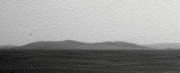  3x height 3x height  variations  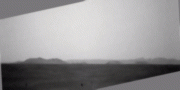 all the above are using Gimp plugin |
|
|
|
|
Feb 28 2010, 04:58 AM
Post
#139
|
|
|
Senior Member Group: Members Posts: 2082 Joined: 13-February 10 From: Ontario Member No.: 5221 |
Is the rim taller or shorter then the Columbia hills? That would be a useful practical comparison. I've tried searching for their height but can't seem to find it anywhere, except McCool hill at around 130 metres or so.
Who knows, Opportunity might do some climbing before EOM. That would be an undisputed "heckuva view", right? 
|
|
|
|
|
Feb 28 2010, 09:21 AM
Post
#140
|
|
|
Senior Member Group: Members Posts: 3516 Joined: 4-November 05 From: North Wales Member No.: 542 |
Explorer, your post has prompted me to do some digging back in relation to possible future hills and vistas. I've remarked on most of this previously but here I've collected some relevant images from earlier posts.
First the contour map from tim53, post 113 above: http://www.unmannedspaceflight.com/index.p...st&id=20806 This shows the downslope increasing quite sharply near the end point of the yellow line. The view forward should become increasingly spectacular over the last km. or so of that route. It also shows that the nearest group of hills to the south rise from a base that is already well down the slope into Endeavour Crater. We do not even see the tops of those hills yet, so for the moment let's call them the 'invisible hills'. Next pgrindrod's excellent visibility map from post 120 above: http://www.unmannedspaceflight.com/index.p...st&id=20817 The invisible hills are aboult half way up that image and indeed show no green shading. Now to go a bit further back here is a crop of the Endeavour HiRise image posted by SFJ Cody in post 105 of the Endeavour thread: http://www.unmannedspaceflight.com/index.p...st&id=16180 I think this shows the northernmost detached part of the invisible hills (rotated 180 degrees?), surrounded by a shoreline-like feature. (**speculation alert - Endeavour Lake???**). Finally, a vertically exaggerated view which nevertheless gives a good impression of the vertical extent of the topography within Endeavour, all of which should be visible from the viewpoint in question. This is from Marswiggle's post 121 in the Endeavour thread: http://www.unmannedspaceflight.com/index.p...st&id=17360 If someone with the google Mars facility could post a virtual panorama from the end of the yellow projected route that would be just wonderful. EDIT: One more handy link to add - a zoomable CTX courtesy of Stu, post 117 in 'Endeavour drive, drivability analysis' thread: http://global-data.mars.asu.edu/ctx/img/P0...1780_XI_02S005W |
|
|
|
|
Feb 28 2010, 03:56 PM
Post
#141
|
|
|
Senior Member Group: Members Posts: 4246 Joined: 17-January 05 Member No.: 152 |
QUOTE (pgrindrod @ Feb 24 2010, 06:33 PM)  Just to show what the underlying DEM looks like for all these viewsheds, here's a couple of coloured hillshades with contours (one with labels, one without). Pete, could you post a higher-resolution version of the plot with contour labels? I was trying to see if your plot agreed with my estimate above of the height of the east rim hill of a bit over 200 metres, but the resolution is not quite enough... |
|
|
|
|
Feb 28 2010, 04:55 PM
Post
#142
|
||
|
Junior Member Group: Members Posts: 59 Joined: 18-July 07 From: London, UK Member No.: 2873 |
hi fredk. i'm afraid this is all i've got with me in houston - will it do? it's the biggest i could squeeze in under 1 mb, but if you pm me i could probably email you a bigger version.
if you need anything else like countours changing, or specific point measurements or profiles, then i'm afraid it'll have to wait until i'm back at ucl. pete |
|
|
|
|
|
|
Feb 28 2010, 10:16 PM
Post
#143
|
|
|
Senior Member Group: Members Posts: 2082 Joined: 13-February 10 From: Ontario Member No.: 5221 |
If the rim is 200 meters, then it's way taller than McCool, the tallest Columbia Hill. Quite a view!
But from what a PM told me there's no good geological reason for Oppy to climb the rim, is there? But I'd be happy to settle for just reaching their base one day. 
|
|
|
|
|
Feb 28 2010, 11:21 PM
Post
#144
|
|
|
Senior Member Group: Members Posts: 3516 Joined: 4-November 05 From: North Wales Member No.: 542 |
Explorer1 I'm trying to help here. On the side we are approaching from (west) Endeavour doesn't have a rim. There is nothing to climb. We should get the view just by descending gradually across the plain to the point where the ground slopes away a bit more steeply into the crater.
|
|
|
|
|
Mar 1 2010, 12:23 AM
Post
#145
|
||
 Senior Member Group: Members Posts: 1628 Joined: 5-March 05 From: Boulder, CO Member No.: 184 |
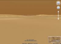
Here's a rough idea looking SE from near Endeavour with Google Mars:
-------------------- Steve [ my home page and planetary maps page ]
|
|
|
|
|
|
|
Mar 1 2010, 01:08 AM
Post
#146
|
|
|
Senior Member Group: Members Posts: 2082 Joined: 13-February 10 From: Ontario Member No.: 5221 |
Oh, that clears it up, thanks!
|
|
|
|
|
Mar 1 2010, 01:23 AM
Post
#147
|
|
|
Senior Member Group: Members Posts: 4246 Joined: 17-January 05 Member No.: 152 |
QUOTE (pgrindrod @ Feb 28 2010, 05:55 PM) hi fredk. i'm afraid this is all i've got with me in houston - will it do? That's great, thanks Pete. I can now read the elevation of east rim hill, and it looks like roughly 200 metres above the surrounding plains. So we are seeing essentially all of that peak above plain level now. But east rim peak is roughly 700 metres above the lowest point inside Endeavour, which happens to be adjacent to east peak. That's some serious topography. |
|
|
|
|
Mar 2 2010, 10:46 PM
Post
#148
|
|
|
Senior Member Group: Members Posts: 3516 Joined: 4-November 05 From: North Wales Member No.: 542 |
Just in case anyone is following this thread but not Nirgal's 3D from 2D magic don't miss these previews of the 'invisible hills':
http://www.unmannedspaceflight.com/index.p...st&p=156307 |
|
|
|
|
Mar 4 2010, 06:52 AM
Post
#149
|
|||
 The Poet Dude Group: Moderator Posts: 5551 Joined: 15-March 04 From: Kendal, Cumbria, UK Member No.: 60 |
Nice...
-------------------- |
||
|
|
|
||
|
Mar 4 2010, 09:00 PM
Post
#150
|
|||
|
Senior Member Group: Members Posts: 4246 Joined: 17-January 05 Member No.: 152 |
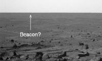
QUOTE (Tesheiner @ Jan 27 2010, 08:00 AM) This is a good place to take a pancam shot on that direction to see if the beacon is still visible too. The new pancam series includes the N to NE horizon, where Victoria would be if it's still visible. Since we'll presumably start dropping soon, this may be our last good chance to see it. I think the Beacon/Cape St. Mary is barely visible. I've pointed to it on this image - the azimuth looks pretty much right, but there's no guarantee we're not just seeing big dunes here:
Check out this post for a comparable previous view of the Beacon, from sol 2039. Doing a Phil-o-vision on the new image, we can perhaps see the outline of Victoria. The angular width is about right:
|
||
|
|
|
||
|

|
Lo-Fi Version | Time is now: 25th April 2024 - 06:58 AM |
|
RULES AND GUIDELINES Please read the Forum Rules and Guidelines before posting. IMAGE COPYRIGHT |
OPINIONS AND MODERATION Opinions expressed on UnmannedSpaceflight.com are those of the individual posters and do not necessarily reflect the opinions of UnmannedSpaceflight.com or The Planetary Society. The all-volunteer UnmannedSpaceflight.com moderation team is wholly independent of The Planetary Society. The Planetary Society has no influence over decisions made by the UnmannedSpaceflight.com moderators. |
SUPPORT THE FORUM Unmannedspaceflight.com is funded by the Planetary Society. Please consider supporting our work and many other projects by donating to the Society or becoming a member. |
|