InSight Cruise Phase, Events during Mars transit prior to EDL |

  |
InSight Cruise Phase, Events during Mars transit prior to EDL |
 Nov 23 2018, 10:02 PM Nov 23 2018, 10:02 PM
Post
#91
|
|
|
Founder  Group: Chairman Posts: 14432 Joined: 8-February 04 Member No.: 1 |
It doesn't actually matter. The s/c will be swinging backwards and forwards under the parachute. It's 'angle of attack' isn't really a thing any more. The s/c uses the IMU at this point to interpret RADAR data, but the actual angle really doesn't matter.
|
 |
 
|
|
Nov 24 2018, 01:15 AM
Post
#92
|
|
|
Merciless Robot Group: Admin Posts: 8783 Joined: 8-December 05 From: Los Angeles Member No.: 602 |
Another way to put it: The angle of attack of the parachute with respect to prevailing airflow should be 90 deg.
-------------------- A few will take this knowledge and use this power of a dream realized as a force for change, an impetus for further discovery to make less ancient dreams real.
|
|
|
|
|
Nov 24 2018, 02:23 AM
Post
#93
|
|
 Member Group: Members Posts: 892 Joined: 15-June 09 From: Lisbon, Portugal Member No.: 4824 |
QUOTE (mcmcmc @ Nov 23 2018, 06:58 PM)  Damn!  If just you'd remebered me before about existence of Google Earth, I could have set up something better than this.... I totally forgot that I can create animations in google earth! Here it is, quick and dirty, using Phoenix's EDL data (rotated and re-centered). You have to play with the slider controls to see the full path. Maybe I'll polish it latter but right now it is way past my shuteye time. Cheers Fernando  InSight_EDL_Sim.kmz ( 11.12K )
Number of downloads: 301
InSight_EDL_Sim.kmz ( 11.12K )
Number of downloads: 301 |
|
|
|
| Guest_mcmcmc_* |
Nov 24 2018, 12:04 PM
Post
#94
|
|
Guests |
QUOTE (nogal @ Nov 24 2018, 03:23 AM) Here it is, quick and dirty, using Phoenix's EDL data (rotated and re-centered). You have to play with the slider controls to see the full path. Maybe I'll polish it latter but right now it is way past my shuteye time. Cheers Fernando
InSight_EDL_Sim.kmz ( 11.12K )
Number of downloads: 301Cool. We should also find a method to: - make a real time video (Google Earth settings do not allow a speed lower than "10 seconds per second") - make markers representing different phases of the landing (I have the images, I have tocleanup them and see if I can make their background transparent) - add camera orientation to each point to create kind of a movie centered on lander In the meantime, I have to finish the other simulator. All in around 55h.  QUOTE It doesn't actually matter. The s/c will be swinging backwards and forwards under the parachute. It's 'angle of attack' isn't really a thing any more. The s/c uses the IMU at this point to interpret RADAR data, but the actual angle really doesn't matter. The point is: if you are going to land on Mars (not "generic you", but you nprev or djellison), wouldn't you like to know in advance how your spaceship/spacecraft/aircraft/whatelse will be oriented during final descent? I would. All this EDLs have to be (also) interpreted as test for future manned landings, but we currently don't know anything about lander attitude between parachute deployment and landing. Additionally, an error in merging and crossprocessing radar data and IMU data by GNC caused fatal failure of Exomars 2016, so design needs a little improvement for this phase, IMHO. |
|
|
|
| Guest_mcmcmc_* |
Nov 24 2018, 12:29 PM
Post
#95
|
|
Guests |
NASA horizons data about Insight usually stopped after 2018-11-26 20:40, and they did not implement at all the landing.
Now they say that landing will happen on november 25th?!? 2458448.318055556, A.D. 2018-Nov-25 19:38:00.0000, 9.125119431869558E-01, 2.735641984023738E+05, -3.024901901551133E+00, 2458448.318750000, A.D. 2018-Nov-25 19:39:00.0000, 9.119065406414170E-01, 2.733827032851672E+05, -3.024935345862831E+00, 2458448.319444444, A.D. 2018-Nov-25 19:40:00.0000, 1.131818709765760E-02, 3.393107130110657E+03, 4.196530165013691E-14, 2458448.320138889, A.D. 2018-Nov-25 19:41:00.0000, 1.131818656712531E-02, 3.393106971061080E+03, -5.212723928404643E-06, 4th datum is distance in km from Mars center; Phoenix landing site in Phoenix EDL data is stated as to be 3376.3 km distant from Mars center, so 3rd line here above appears to describe a landing happening at right time but in wrong date.
|
|
|
|
| Guest_mcmcmc_* |
Nov 24 2018, 12:34 PM
Post
#96
|
|
Guests |
Declared sources for Horizons data:
CODE Trajectory files Start (TDB) End (TDB) -------------------------------------- ----------------- ----------------- od002_v1.V0.1 2018-May-05 12:39 2018-May-05 21:00 od037_v1_delTCAL.V0.1 2018-May-05 21:00 2018-Jun-08 00:00 od092_v1.V0.1 2018-Jun-08 00:00 2018-Jul-29 00:01 od102_v1.V0.1 2018-Jul-29 00:01 2018-Nov-25 19:40 4day_landed.V0.1 2018-Nov-25 19:40 2018-Nov-29 19:40 are we missing something?!? |
|
|
|
| Guest_mcmcmc_* |
Nov 24 2018, 03:30 PM
Post
#97
|
|
|
Guests |
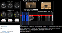
Simulator is eventually finished: I cleaned it up, added official Twitter feed, NASA live video and descriptions for all phases.
http://win98.altervista.org/space/explorat...-simulator.html
Attached thumbnail(s)
|
|
|
|
|
|
|
Nov 24 2018, 03:33 PM
Post
#98
|
|
|
Founder Group: Chairman Posts: 14432 Joined: 8-February 04 Member No.: 1 |
QUOTE (mcmcmc @ Nov 24 2018, 04:04 AM) wouldn't you like to know in advance how your spaceship/spacecraft/aircraft/whatelse will be oriented during final descent? I would. What point are you trying to make? That we should be able to invent some impossible simulation technology in advance of EDL in complete defiance of chaos theory? Or that a spacecraft swinging under a parachute should expend fuel unnecessarily to control it's attitude? The vehicle knows it's attitude at the time, and conducts an appropriate heading change during the powered decent stage so it lands at the correct orientation. Phoenix executed the same EDL method well. I'd suggest reading several of the post landing reconstruction analysis papers such as this one http://citeseerx.ist.psu.edu/viewdoc/downl...p1&type=pdf This landing system has no common heritage with ExoMars. |
|
|
|
|
Nov 24 2018, 03:34 PM
Post
#99
|
|
|
Senior Member Group: Members Posts: 2511 Joined: 13-September 05 Member No.: 497 |
QUOTE (mcmcmc @ Nov 24 2018, 04:04 AM) The point is: if you are going to land on Mars (not "generic you", but you nprev or djellison), wouldn't you like to know in advance how your spaceship/spacecraft/aircraft/whatelse will be oriented during final descent? You need to calm down a little. Certainly for previous landings there have been a lot of simulations of what the attitude on chute was, and we used them to calculate exposure times, photometric angles, etc, but at best they were measures of what could have happened. Nobody expected them to look much like reality, and they didn't. For example, the MSL descent was much less oscillatory than some of the simulations. -------------------- Disclaimer: This post is based on public information only. Any opinions are my own.
|
|
|
|
| Guest_mcmcmc_* |
Nov 24 2018, 03:43 PM
Post
#100
|
|
Guests |
QUOTE (djellison @ Nov 24 2018, 04:33 PM) I'd suggest reading several of the post landing reconstruction analysis papers such Thanks, I've already read 6 of them: all complain about unexpainable terribly wrong data about attack angle after parachute deployment, and some of them presume that wind could be a possible cause, and the authors presume that radar could help fixing the data, but I was not able to find any EDL analysis report taking into account radar data. Note that they don't say that this is a critical point; they just say that "nothing is known about spacecraft attitude between parachute jettisoning and landing, but it's evident that it is good as spacecrafts usually land safely" (this sounds a little scary to me, being an engineer). This is why I think that the parachute-to-landing phase design needs some improvements (currently it sounds like "hey, let's hope all goes fine, we can't do anything better here"). Instead, all other phases look very precisely designed against any possible Murphy attack. |
|
|
|
| Guest_mcmcmc_* |
Nov 24 2018, 03:53 PM
Post
#101
|
|
Guests |
QUOTE (mcaplinger @ Nov 24 2018, 04:34 PM) You need to calm down a little. Certainly for previous landings there have been a lot of simulations of what the attitude on chute was, and we used them to calculate exposure times, photometric angles, etc, but at best they were measures of what could have happened. Nobody expected them to look much like reality, and they didn't. For example, the MSL descent was much less oscillatory than some of the simulations. I have 4 questions about parachute-to-landing phase: 1) which is the maximum tilt any lander can tolerate for a safe landing? 2) which is the maximum transverse wind speed any lander can tolerate for a safe landing? 3) How can I determine the better direction for BAM if I don't know wind direction and speed? 4) How can we answer above questions without any method available to know lander tilt and wind speed and direction during landing? (or maybe there are methods, but I dind't find them in stuff I 've read). |
|
|
|
|
Nov 24 2018, 04:25 PM
Post
#102
|
|
|
Senior Member Group: Members Posts: 2511 Joined: 13-September 05 Member No.: 497 |
The way EDL is validated is that many Monte Carlo runs are done with all of the parameters varied across their expected ranges and we see if the landing is successful.
Most of this is covered by ITAR so I wouldn't expect to see public information about the specifics. -------------------- Disclaimer: This post is based on public information only. Any opinions are my own.
|
|
|
|
|
Nov 24 2018, 04:41 PM
Post
#103
|
|
|
Senior Member Group: Members Posts: 2511 Joined: 13-September 05 Member No.: 497 |
QUOTE (mcmcmc @ Nov 24 2018, 07:53 AM) How can we answer above questions without any method available to know lander tilt and wind speed and direction during landing? The tilt at landing is well-known from looking at the gravity vector and the vehicle is actively controlling its attitude during powered descent. The tilt in the last 10 seconds of parachute descent, for example, is completely irrelevant to the tilt at landing. Varying atmospheric conditions are the major reason that the landing ellipses are relatively large. -------------------- Disclaimer: This post is based on public information only. Any opinions are my own.
|
|
|
|
| Guest_mcmcmc_* |
Nov 24 2018, 05:43 PM
Post
#104
|
|
Guests |
To "touch with your hand" Insight, or at least to get an idea of its real size, here it is the official NASA JPL app with ARCore support (i.e. no printed markers needed, just Android 7+ and a floor):
https://play.google.com/store/apps/details?...aftAR&hl=en |
|
|
|
| Guest_mcmcmc_* |
Nov 24 2018, 07:14 PM
Post
#105
|
|
Guests |
QUOTE (nogal @ Nov 24 2018, 03:23 AM) Here it is, quick and dirty, using Phoenix's EDL data (rotated and re-centered). You have to play with the slider controls to see the full path. Maybe I'll polish it latter but right now it is way past my shuteye time. Cheers Fernando
InSight_EDL_Sim.kmz ( 11.12K )
Number of downloads: 301This file includes: - same descent profile of my previous file (centered on Phoenix landing site) - different images with transparency, representing lander in various configurations. Unfortunately I can no more work on it till 2018-11-25 10:00 GMT, maybe you've best luck? |
|
|
|
|

|
Lo-Fi Version | Time is now: 2nd May 2024 - 11:15 PM |
|
RULES AND GUIDELINES Please read the Forum Rules and Guidelines before posting. IMAGE COPYRIGHT |
OPINIONS AND MODERATION Opinions expressed on UnmannedSpaceflight.com are those of the individual posters and do not necessarily reflect the opinions of UnmannedSpaceflight.com or The Planetary Society. The all-volunteer UnmannedSpaceflight.com moderation team is wholly independent of The Planetary Society. The Planetary Society has no influence over decisions made by the UnmannedSpaceflight.com moderators. |
SUPPORT THE FORUM Unmannedspaceflight.com is funded by the Planetary Society. Please consider supporting our work and many other projects by donating to the Society or becoming a member. |
|