Printable Version of Topic
Click here to view this topic in its original format
Unmanned Spaceflight.com _ Lunar Exploration _ Exploring LROC NAC images
Posted by: cassioli Sep 18 2010, 01:22 PM
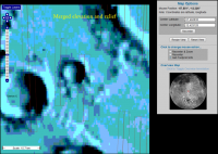
I found http://wms.lroc.asu.edu/lroc#damoon for LRO images, but I can't unerstand if/how it is possible to know lat/lon of a point in the zoomed image.
If not, is there any site/program which allows to do this?
Posted by: Phil Stooke Sep 18 2010, 01:33 PM
The site tells you the lat and long of the top and bottom, left and right corners. A point inside it can be estimated by interpolation. Not very difficult!
Phil
Posted by: cassioli Sep 18 2010, 01:37 PM

Phil
it IS difficult: try finding an object in one of those image, even if you know its coordinates!
Posted by: tedstryk Sep 18 2010, 06:12 PM
For those who are unwilling to put forth the slightest thought or effort, maybe. It is quite easy to use.
Posted by: cassioli Sep 18 2010, 06:30 PM
being argumentative is useless.
answers to my questions are:
no, is not possible.
no, there is no site/sw which allow doing that.
Posted by: tedstryk Sep 18 2010, 06:34 PM
answers to my questions are:
no, is not possible.
no, there is no site/sw which allow doing that.
LOL, a multiple choice question?

Posted by: Juramike Sep 18 2010, 10:09 PM
Something's not quite right here....
Posted by: Juramike Sep 18 2010, 11:10 PM
Here's part of the problem. The base maps are all offset.
Here is a GIF of a series of screenshots centered on a cute crater* to the northeast of Clavius D: toggling through the different layers, you can see that although the NAC footprints don't move, the background maps are all over the place.
|
[* Animated GIF: Click to animate *]
So this map can get you kinda close, but you'll need to line up features in the actual LRO image to the terrain to see where you really are. Google Earth (Moon) might be your best friend here.
*the small bright crater inside this crater has some neat blocks exposed.
Posted by: elakdawalla Sep 18 2010, 11:20 PM
This used to be a serious problem for Mars too; it's thanks to the MOLA maps that there is now such good control of image locations. It amazes me every time I go into Google Mars and see how well things generally line up. Locational control of image data sets for the Moon will eventually improve with the help of the LOLA data set.
The point is that latitude and longitude will only get you so far. If you're looking for something in one data set at a given latitude and longitude measured off an image from a different data set, you'll probably have to make your own grid overlaid on both images in which you match features obvious in both data sets, then look for that needle in a haystack at its proper grid location in the new image. It's not as easy as an entire data set being offset by some constant; the locations are imprecise, so one image might be off in one direction, another might be off in a different direction. Phil Stooke might have a handle on just how large this imprecision is for different data sets.
Posted by: Juramike Sep 18 2010, 11:33 PM
Are the NAC images flipped? (left-right reflected) I'm having a hard time getting them to match up to the Google Moon images..but flipping (sometimes upside down AND left-right) seems to do the trick.
Posted by: ugordan Sep 19 2010, 12:39 AM
That's a 180 degree rotation. It's probably due to the simple fact some swaths were taken on ascending and some on descending node so north direction differs by 180 deg.
Posted by: Juramike Sep 19 2010, 12:59 AM
I'm getting an E-W mirroring as well that I can't figure out. (Even after rotating).
Posted by: elakdawalla Sep 19 2010, 02:56 AM
See http://www.planetary.org/blog/article/00002422/ for an explanation of the occasional E-W mirroring (though not, sadly, any useful information on how to tell when the image is flipped, except by comparing it with older photos).
Posted by: Juramike Sep 19 2010, 04:07 AM
Thanks!
Posted by: cassioli Sep 19 2010, 12:23 PM
What I can't understand is how people is able to find in these images ancient spacecraft wrecks just 10 pixel wide, just by knowing which their position should be, if it is so hard to determine lat/lon on these images!
Anyway I found this http://ltvt.wikispaces.com/which allows calibrating an image and overlaying it to a moon model. I didn't yet figure out prperly how to use the program... but as far as I unerstand, it requires .LBL files associated to .IMG files, to calibrate the images. But.. where are these files?!? Ok, I can calibrate by hand, but of course a ready-made file would be much more precise!
Posted by: Phil Stooke Sep 19 2010, 01:35 PM
Cassioli, it does not work that way. The coordinates are only a very rough guide. Typically, for previously unseen impacts like Ranger 6, the coordinates might tell us which 25% of the height of an image to look in, but it might lie in that image or in one on either side of it. The uncertainty is very great. Researchers are looking for a very fresh-looking crater with distinctive crater morphology, somewhere within that region of uncertainty. It is of course different if we have previous images of the site. For instance, Ranger 9's crater was seen by Apollo 16 (and the impact point was seen before impact by Ranger 9 itself). There, we know exactly where to look, but not from the coordinates. After it's found, the true coordinates are found by interpolation from the corner coordinates, which are themselves calculated from the spacecraft location and pointing estimates.
Phil
Posted by: Juramike Sep 20 2010, 11:44 PM
(Crosslink to a more detailed explanation of flipping and coordinates by Phil on another thread http://www.unmannedspaceflight.com/index.php?s=&showtopic=6070&view=findpost&p=164279. Thanks, Phil!)
Posted by: Phil Stooke Jun 28 2011, 02:08 PM
Here's a pic of a curious feature I had poinrted out once before, but with different images. A sort of Ina-like feature in Mare Tranquillitatis. There are more of these in Hyginus. How many more will turn up, I wonder?
Phil
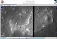
|
Posted by: Phil Stooke Jun 28 2011, 02:21 PM
... and here's another one not far from that one (note coordinates at lower right). This one is a new discovery.
Phil
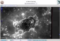
|
Posted by: john_s Jun 28 2011, 03:31 PM
The first of those, at least, looks to me like a kipuka (I just wanted an excuse to use that word- Hawaiian for "a depression between surrounding lava flows"). The terrain inside the depression seems unremarkable- just a region that happened not to be covered by the last lava flow. The flow fronts do look remarkably fresh, though. The second one I'm not so sure- hard to tell given the lighting but there seem to be some unusual textures in there.
John
Powered by Invision Power Board (http://www.invisionboard.com)
© Invision Power Services (http://www.invisionpower.com)