Chandrayaan 3 lander and rover, India's lunar mission to replace Chandrayaan 2's lander/rover |

  |
Chandrayaan 3 lander and rover, India's lunar mission to replace Chandrayaan 2's lander/rover |
 Sep 24 2023, 07:54 PM Sep 24 2023, 07:54 PM
Post
#196
|
||
|
Solar System Cartographer  Group: Members Posts: 10153 Joined: 5-April 05 From: Canada Member No.: 227 |
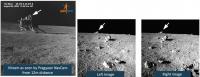
Thank you for letting us see that.
The slide from the video showed the view of the lander that we have already seen as well as the two new ones. When I compare them... it looks like the object on the horizon of the rocks stereo image is the top of the lander, just visible over a small local rise in the terrain. Phil
-------------------- ... because the Solar System ain't gonna map itself.
Also to be found posting similar content on https://mastodon.social/@PhilStooke Maps for download (free PD: https://upload.wikimedia.org/wikipedia/comm...Cartography.pdf NOTE: everything created by me which I post on UMSF is considered to be in the public domain (NOT CC, public domain) |
|
 |
 
|
|
|
Sep 24 2023, 09:13 PM
Post
#197
|
|
|
Member Group: Members Posts: 103 Joined: 12-September 19 Member No.: 8664 |
And here I was thinking they are just very strange outcrop of rocks. That indeed looks like top of lander, really nice catch.
|
|
|
|
|
Oct 4 2023, 03:38 PM
Post
#198
|
||
|
Junior Member Group: Members Posts: 45 Joined: 23-July 11 Member No.: 6083 |
There's been an addition of around 40 new files at the Chandrayaan-2 OHRC page, and a hefty chunk of them seem to focus on the Chandrayaan-3 lander/rover.
Edit to add: most of the files around the lander site seem to pre-date it, with only this post-landing image to go at so far:
|
|
|
|
|
|
|
Oct 6 2023, 09:40 PM
Post
#199
|
||
|
Member Group: Members Posts: 103 Joined: 12-September 19 Member No.: 8664 |
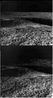
Another Navcam pair from IAC 2023 presentation.
https://www.youtube.com/watch?v=iY9qIBTZV8E&t=1008s Showing the 4 meter crater encountered on 27 August.
Attached thumbnail(s)
|
|
|
|
|
|
|
Oct 24 2023, 06:34 PM
Post
#200
|
|
|
Solar System Cartographer Group: Members Posts: 10153 Joined: 5-April 05 From: Canada Member No.: 227 |
https://www.youtube.com/watch?v=6ZRJ54SKUX8
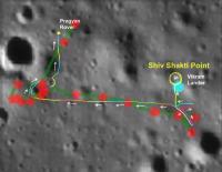
This link is to a very interesting talk by Santosh Vadawale of the Physical Research Lab in Ahmedabad, the PI for the APXS on the Pragyan rover. It goes from the beginning of discussions about the instrument to flight operations. Among the interesting points, the fixed solar panel on Pragyan plus the motion of the Sun across the sky originally dictated a counterclockwise traverse after deployment. That route was blocked by craters so a 'backwards' path was selected, requiring a 180 degree turn after every drive to charge the battery. Also a map of locations of the APXS measurements (of which more later). The hop at the end of the lunar day was preceded by a short test burn. Phil -------------------- ... because the Solar System ain't gonna map itself.
Also to be found posting similar content on https://mastodon.social/@PhilStooke Maps for download (free PD: https://upload.wikimedia.org/wikipedia/comm...Cartography.pdf NOTE: everything created by me which I post on UMSF is considered to be in the public domain (NOT CC, public domain) |
|
|
|
|
Oct 24 2023, 06:47 PM
Post
#201
|
||
|
Solar System Cartographer Group: Members Posts: 10153 Joined: 5-April 05 From: Canada Member No.: 227 |
About the APXS map. Here it is, superimposed on the earlier ISRO map. There are multiple points of disagreement. We can say that the definitive map is not yet available. One thing that will help will be a post-mission OHRC image which might show the rover and clarify its location. The lander location is more accurate on the APXS map.
Phil
-------------------- ... because the Solar System ain't gonna map itself.
Also to be found posting similar content on https://mastodon.social/@PhilStooke Maps for download (free PD: https://upload.wikimedia.org/wikipedia/comm...Cartography.pdf NOTE: everything created by me which I post on UMSF is considered to be in the public domain (NOT CC, public domain) |
|
|
|
|
|
|
Jan 29 2024, 03:23 AM
Post
#202
|
||
|
Solar System Cartographer Group: Members Posts: 10153 Joined: 5-April 05 From: Canada Member No.: 227 |
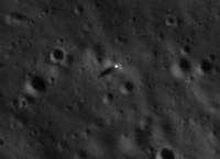
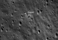
Shan Subramanian has tweeted this LRO image:
https://twitter.com/Ramanean/status/1750895541045915669 I compared it with the OHRC image used as a background to the rover traverse map. There seems to be a feature casting a shadow like the lander but smaller and not present in older images. It is close to where the previous maps placed Pragyan so it is probably the rover.
Phil -------------------- ... because the Solar System ain't gonna map itself.
Also to be found posting similar content on https://mastodon.social/@PhilStooke Maps for download (free PD: https://upload.wikimedia.org/wikipedia/comm...Cartography.pdf NOTE: everything created by me which I post on UMSF is considered to be in the public domain (NOT CC, public domain) |
|
|
|
|
|
|
Mar 24 2024, 11:47 AM
Post
#203
|
|
|
Member Group: Members Posts: 103 Joined: 12-September 19 Member No.: 8664 |
IAU approves Statio Shiv Shakti as name for Vikram-2 landing site.
https://planetarynames.wr.usgs.gov/Feature/16272 QUOTE Compound word from Indian mythology that depicts the masculine (Shiva) and feminine (Shakti) duality of nature; Landing site of Chandrayaan-3s Vikram lander.
|
|
|
|
|

|
Lo-Fi Version | Time is now: 28th April 2024 - 09:09 PM |
|
RULES AND GUIDELINES Please read the Forum Rules and Guidelines before posting. IMAGE COPYRIGHT |
OPINIONS AND MODERATION Opinions expressed on UnmannedSpaceflight.com are those of the individual posters and do not necessarily reflect the opinions of UnmannedSpaceflight.com or The Planetary Society. The all-volunteer UnmannedSpaceflight.com moderation team is wholly independent of The Planetary Society. The Planetary Society has no influence over decisions made by the UnmannedSpaceflight.com moderators. |
SUPPORT THE FORUM Unmannedspaceflight.com is funded by the Planetary Society. Please consider supporting our work and many other projects by donating to the Society or becoming a member. |
|