Endeavour Drive - Drivability analysis |

  |
Endeavour Drive - Drivability analysis |
 Oct 3 2008, 07:36 PM Oct 3 2008, 07:36 PM
Post
#481
|
|
 Senior Member  Group: Members Posts: 1229 Joined: 24-December 05 From: The blue one in between the yellow and red ones. Member No.: 618 |
QUOTE (PDP8E @ Oct 3 2008, 09:14 AM) 
Well, it ain't got a back set or a rear window But it still gets me where I wanna go -------------------- My Grandpa goes to Mars every day and all I get are these lousy T-shirts!
|
 |
 
|
|
Oct 3 2008, 07:44 PM
Post
#482
|
|
|
Member Group: Admin Posts: 976 Joined: 29-September 06 From: Pasadena, CA - USA Member No.: 1200 |
QUOTE (climber @ Oct 3 2008, 11:01 AM) I understand the question as a single drive where we know how wide the corridor has to be but not the lenght. Regarding actual power and puting every ressource on the drive, what do you think we can plan for? 300 metres? Sorry for not being clear. Either single drive or consecutive sols drive. NO, I was not asking for a path to Endeavour. Paolo -------------------- Disclaimer: all opinions, ideas and information included here are my own,and should not be intended to represent opinion or policy of my employer.
|
|
|
|
|
Oct 3 2008, 07:48 PM
Post
#483
|
|
|
Member Group: Admin Posts: 976 Joined: 29-September 06 From: Pasadena, CA - USA Member No.: 1200 |
QUOTE (PDP8E @ Oct 3 2008, 11:14 AM) ...
Alas, I think that one of the major differences between manned and unmanned space exploration is duct tape. Can you imagine how useful a DDD (DuctTape Deployment Device) would have been? Paolo -------------------- Disclaimer: all opinions, ideas and information included here are my own,and should not be intended to represent opinion or policy of my employer.
|
|
|
|
|
Oct 3 2008, 08:05 PM
Post
#484
|
|
 Senior Member Group: Moderator Posts: 2785 Joined: 10-November 06 From: Pasadena, CA Member No.: 1345 |
For figuring the absolute scale of HiRise imagery:
I got rover dimensions of 2.3 m wide, and 1.6 m long. I also found this image (PIA05229) (Fig. 2 has a scale - thus Endurance crater can be used for a 200 m reference) Eagle crater is ca. 30 m diameter {Wikipedia to the rescue again! Wikipedia/Eagle (crater)} Does anyone know the dimensions (in meters) of the lander in unfolded conformation? -Mike -------------------- Some higher resolution images available at my photostream: http://www.flickr.com/photos/31678681@N07/
|
|
|
|
|
Oct 3 2008, 08:26 PM
Post
#485
|
|
|
Senior Member Group: Members Posts: 2920 Joined: 14-February 06 From: Very close to the Pyrénées Mountains (France) Member No.: 682 |
QUOTE (RoverDriver @ Oct 3 2008, 09:48 PM) Can you imagine how useful a DDD (DuctTape Deployment Device) would have been? Paolo You'd have need to add a... Duct Bay 
-------------------- |
|
|
|
|
Oct 3 2008, 08:55 PM
Post
#486
|
|
|
Senior Member Group: Moderator Posts: 2785 Joined: 10-November 06 From: Pasadena, CA Member No.: 1345 |
QUOTE (climber @ Oct 3 2008, 03:26 PM) You'd have need to add a... Duct Bay <ducks> -------------------- Some higher resolution images available at my photostream: http://www.flickr.com/photos/31678681@N07/
|
|
|
|
|
Oct 4 2008, 08:31 AM
Post
#487
|
||
|
Newbie Group: Members Posts: 16 Joined: 24-September 08 Member No.: 4351 |
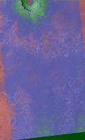
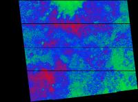
Well, better late than never! I tried many different plans of attack, but in the end could find no combination of attributes that did any better than the single attribute of mean spacing of the ripples as derived from my 2dfft filter. The texture classifier I played with for a while will only give improved results if there are several attributes that together segment the image, but in this case I could not find such suitable attributes. They either weren't very diagnostic or were highly correlated with the spacing attribute. Even the 2dfft is probably overkill, since all the ripples are all in virtually the same direction. So I think my result is very similar to James' result, although I colored it somewhat more optimistically. I also did some work on attempting to pick the ripples to identify the highly curved segments, but nothing worked as well as the very elegant and simple method of SteveM's!
A side note - you will see in my images that the sides of the image appear different than the center. It appears that several images were combined to form the image I started from, and while there is no visual difference (at least to my eye), the difference stands out clearly in many of my computed attributes. For example, the standard deviation of the pixel values is quite different. Did others find this problem, and how did you get around it? Did you start with PSP_005423_1780_RED.QLOOK.JP2 as I think I did, or from a different source? I have several results to show, and I will spread them out over several posts. All the images here are jpgs, which I needed to use for size reasons. They are also chopped down to some degree. Because of time, I did my analysis only on every 5th pixel in each direction, and put the result in the surrounding 25 pixels in the original image. So I could shrink the result by this factor with no loss of information. All but the main result I shrunk again just to save space. I have all the png files at the 5x5 shrunk scale, which are of the order 20MB, but I don't have any place of my own to post them, and I don't have any experience with sites out there that will host it for me. I'll be happy to provide them if anyone can give me some instructions. Now that I've put you to sleep with my rambling - here is my result! Bill
Attached thumbnail(s)
|
|
|
|
|
|
|
Oct 4 2008, 08:38 AM
Post
#488
|
||
|
Newbie Group: Members Posts: 16 Joined: 24-September 08 Member No.: 4351 |
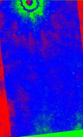
In this post I will attach just the raw color classification. Artifacts from jpg compression are evident, but of course aren't on the original png file.
Bill
Attached thumbnail(s)
|
|
|
|
|
|
|
Oct 4 2008, 08:52 AM
Post
#489
|
|||
|
Newbie Group: Members Posts: 16 Joined: 24-September 08 Member No.: 4351 |
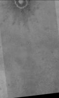
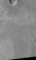
And finally I post the actual values of the 2dfft attribute as a greyscale image. I post it along side the original photographic image at the same scale. To my eye, it does appear that I can see things in the processed image that I cannot in the original. I agree with CosmicRocker that the main lobed features are present in both, but the processed image really does look to me to contain rays, more so than the original. I suspect it has to do with slight topographic highs along the rays, where the sand tends not to accumulate, hence smaller dunes. I would expect such a topographic pattern shortly after imact, but it is surprising it has perisisted to present, if that is the cause.
Bill
Attached thumbnail(s)
|
||
|
|
|
||
|
Oct 4 2008, 08:56 AM
Post
#490
|
|
|
Senior Member Group: Members Posts: 2920 Joined: 14-February 06 From: Very close to the Pyrénées Mountains (France) Member No.: 682 |
I think the best actual reference to be compared with the dunes we'll have to cross/not cross are the dunes inside Victoria that appear "not so red" but were we can see shape & height.
hey probably not formed the same way as the one on the plain but, is that of any help? -------------------- |
|
|
|
|
Oct 4 2008, 11:53 AM
Post
#491
|
|
|
Senior Member Group: Moderator Posts: 2785 Joined: 10-November 06 From: Pasadena, CA Member No.: 1345 |
QUOTE (wbutler @ Oct 4 2008, 03:31 AM) I have all the png files at the 5x5 shrunk scale, which are of the order 20MB, but I don't have any place of my own to post them, and I don't have any experience with sites out there that will host it for me. I'll be happy to provide them if anyone can give me some instructions.l Try speedyshare.com. They will let you upload up to a 30 Mb (actually, I got away with 30.2 Mb) file and they will host it for free. After 7 days with no downloads they delete it. It's amazingly simple, you upload a file and they provide a url to copy/paste for download. The downside is that the site usually has an advertisement pop-up window that you wouldn't want your co-workers, kids, or significant others to see. ("Honest, honey, it's for planetary science....") (Yes, you too can become the Porn King of Mars). -Mike -------------------- Some higher resolution images available at my photostream: http://www.flickr.com/photos/31678681@N07/
|
|
|
|
|
Oct 4 2008, 06:24 PM
Post
#492
|
|
 Junior Member Group: Members Posts: 82 Joined: 22-July 05 From: Portugal Member No.: 445 |
|
|
|
|
|
Oct 6 2008, 07:32 PM
Post
#493
|
|
|
Newbie Group: Members Posts: 16 Joined: 24-September 08 Member No.: 4351 |
I have uploaded my png files to speedyshare - thanks to Juramike for the suggestion. The links are:
http://www.speedyshare.com/217480217.html - final blended result of diagnostic and terrain http://www.speedyshare.com/119902873.html - diagnostic only as green/blue/red http://www.speedyshare.com/473996607.html - diagnostic only as greyscale Let me know if I screwed something up and you can't access for any reason. Thanks! Bill |
|
|
|
|
Oct 6 2008, 08:07 PM
Post
#494
|
|
|
Senior Member Group: Members Posts: 1229 Joined: 24-December 05 From: The blue one in between the yellow and red ones. Member No.: 618 |
Certainly looks like wonderful stuff to me. Can't wait for the whole Victoria - Endeavour swath with the new HiRISE.
But after that, the task will be to pore over the maximum resolution images looking for interesting cobble patches, superimpose them on this image (I don't know, as gold or silver stars, or something) then draw a track that sticks to the blue-green, avoids the gnarly red zones, connects as many stars as possible, includes patches of exposed bedrock at regular intervals, and ends up at some juicy piece of Endeavour rim exposure. Bob's your uncle! Hot ziggity! This is really gonna work! 
-------------------- My Grandpa goes to Mars every day and all I get are these lousy T-shirts!
|
|
|
|
|
Oct 6 2008, 08:18 PM
Post
#495
|
||
|
Senior Member Group: Moderator Posts: 2785 Joined: 10-November 06 From: Pasadena, CA Member No.: 1345 |
I've uploaded my non-overlaid tiff files to speedyshare (30 Mb each)
http://www.speedyshare.com/356927428.html - 12.5% resolution (red-blue-green) non overlaid composite http://www.speedyshare.com/787485233.html - 12.5% resolution (red-blue-green) terrain overlaid composite Here is a link to a .pdf doc describing the exact method and showing a step-by-step example for the area near Beagle Crater - NW Victoria Crater apron (2.5 Mb): http://www.speedyshare.com/931443814.html And here is the unoverlaid Differential Shift 10E5S image:
-Mike -------------------- Some higher resolution images available at my photostream: http://www.flickr.com/photos/31678681@N07/
|
|
|
|
|
|
|

|
Lo-Fi Version | Time is now: 27th April 2024 - 12:35 AM |
|
RULES AND GUIDELINES Please read the Forum Rules and Guidelines before posting. IMAGE COPYRIGHT |
OPINIONS AND MODERATION Opinions expressed on UnmannedSpaceflight.com are those of the individual posters and do not necessarily reflect the opinions of UnmannedSpaceflight.com or The Planetary Society. The all-volunteer UnmannedSpaceflight.com moderation team is wholly independent of The Planetary Society. The Planetary Society has no influence over decisions made by the UnmannedSpaceflight.com moderators. |
SUPPORT THE FORUM Unmannedspaceflight.com is funded by the Planetary Society. Please consider supporting our work and many other projects by donating to the Society or becoming a member. |
|