2007-09-10 Iapetus (rev 49): Pre-flyby discussion, Closest approach of this odd moon |

 Unmanned Spaceflight.com > Outer Solar System > Saturn > Cassini Huygens > Cassini's ongoing mission and raw images
  |
2007-09-10 Iapetus (rev 49): Pre-flyby discussion, Closest approach of this odd moon |
 Jan 20 2007, 11:35 PM Jan 20 2007, 11:35 PM
Post
#1
|
|
 Member  Group: Members Posts: 288 Joined: 28-September 05 From: Orion arm Member No.: 516 |
Hi,
let me open this thread on the closest Iapetus flyby on September 10th later this year. Hopefully we'll get some more clues to solve the mysteries of this odd moon, like the origin of the equatorial ridge and the brightness differance... First, some new infos given by Tilmann Denk from FU Berlin: CASSINI will pass Iapetus in roughly 1600 km. An UVIS star occultation of sigma Sagitarii will now occur about 1 hour before closest approach - instead of during it. This will now allow an additional window for high resolved pics of the highest known parts of the equatorial ridge at 160° (phase between ~140° and ~30°) now, apparently a decisive approvement of this encounter. Detailed planing can be started soon...   Bye. |
 |
 
|
|
Feb 13 2007, 07:12 PM
Post
#2
|
|
 Senior Member Group: Members Posts: 1628 Joined: 5-March 05 From: Boulder, CO Member No.: 184 |
I may have posted this view somewhere using my map along with Celestia, illustrating the unseen terrain to be imaged...
http://laps.noaa.gov/albers/sos/saturn/iap...tus_sep2007.jpg -------------------- Steve [ my home page and planetary maps page ]
|
|
|
|
|
Mar 18 2007, 02:50 PM
Post
#3
|
|
|
Member Group: Members Posts: 509 Joined: 2-July 05 From: Calgary, Alberta Member No.: 426 |
This new abstract on the "White Mountains" has popped up on the Voyager-Pioneer thread recently:
http://www.lpi.usra.edu/meetings/lpsc2000/pdf/1596.pdf The notion that these mountains could have been created by a large meteorite that hit Iapetus at low speed and broke into pieces seems awfully weak. Is that supposed to explain why most of them are lined up with the "belly band", and why they're white while most of the terrain around them is black? Iapetus seems to be good at getting people to grab at straws when it comes to theorizing. Sometimes it's better simply to admit that you don't know. Given that we've never seen those mountains in decent detail, there's no shame in that. |
|
|
|
|
Mar 19 2007, 11:34 AM
Post
#4
|
||
|
Member Group: Members Posts: 288 Joined: 28-September 05 From: Orion arm Member No.: 516 |
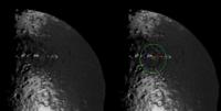
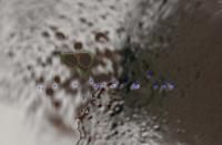
QUOTE (Rob Pinnegar @ Mar 18 2007, 03:50 PM)  Iapetus seems to be good at getting people to grab at straws when it comes to theorizing. Yes, there's a lot of speculation about Iapetus and its strange anomalies...Sometimes it's better simply to admit that you don't know. Given that we've never seen those mountains in decent detail, there's no shame in that. But with a lack of well resolved imagery - what should be expected else? Referring to the 'white mountains', here a point I posted about a year ago: Visible is a large bassin in the western part of CR (inside the large green circle) cut by the part of the ridge with the 'white peaks' (red line).
My impression is that its central peak (small green circle) doesn't coincide with the 'white peak' NW of it and it is also lower. Thus the crater must be older than the 'white mountains'. This 'white peak' seems to cast an enormous shadow (blue quadrangle) to its western side. Is the equatorial ridge interrupted there? Is there any ridge at all or only these 'white peaks'? We'll see on September 10th ...  Till then, a 3-dimensional topographic analysis of the shadow casting in this region would be quite interesting I guess. Anyone out there taking the task? Bye. |
|
|
|
|
|
|
Apr 12 2007, 09:34 PM
Post
#5
|
|
|
Member Group: Members Posts: 288 Joined: 28-September 05 From: Orion arm Member No.: 516 |
Hi,
a global mosaic of the trailing side consisting of 15 footprints is now fixed. Resolution will be 422-456 m/pxl. Final planning on other mosaics (particularly the 'White Mountains') will be completed in May. Bye. |
|
|
|
|
Apr 22 2007, 10:29 PM
Post
#6
|
|
|
Member Group: Members Posts: 288 Joined: 28-September 05 From: Orion arm Member No.: 516 |
Hi again,
some more infos on the september fly-by: The observation window for the VIMS/ISS-request during closest approach will be about 4 hours (13:27 - 17:16 UTC), image resolution of the ISS-telecamera 40...10...148 m/pxl. A 2+2+3-mosaic of the equatorial ridge at 140° will first be taken under high phase angle. Then the 'White moutains' (higher then 20 km?) will be imaged by WAC (~150 m/pxl). During closest approach as phase angle will rapidly decline the equator region at 165° will be observed. (at this longitude the ridge is presumably coming to an abrupt end). After closest approach a scan with CIRS-spectrometer will be conducted at 12°S/168°W ('average dark terrain'), followed by a CIRS-Scan at 42°S/209°W ('average bright terrain'). Next a 1x6-mosaic of the 'White moutains' - now at low phase angle - will be taken. 1 hour after closest approach NAC resolution will be 40-50 m/pxl for this mosaic. After that some infrarotspectrometer (VIMS) observations will be conducted, longitude hasn't been chosen so far. A large mosaic of the equatorial transition zone from west (~190°W) to east (~250°W) as 3x4 + 3x3 mosaic will be taken next. Duration roughly 1 hour, resolution 80-130 m/pxl. Next there will be a 'terminator mapping' at 300°W, followed by the attempt to capure the 'Moat' in saturnshine. Other observations will follow, e.g. the mentioned global mosaic of the trailing side consisting of 15 footprints (422-456 m/pxl). Final planning for the fly-by will be finished by end of May, as Tilmann Denk from FU Berlin informed me. Bye. |
|
|
|
|
Apr 27 2007, 08:34 AM
Post
#7
|
||
|
Member Group: Members Posts: 288 Joined: 28-September 05 From: Orion arm Member No.: 516 |
...some additional infos I recieved from Tilmann Denk yesterday:
During approach (Iapetus in high phase) polar regions of the saturn facing side should be imaged in saturnshine - resolution ~480 m/pxl. QUOTE A 2+2+3-mosaic of the equatorial ridge at 140° will first be taken under high phase angle. Also NAC of the peaks will be taken (~15 m/pxl), but exact pointing roughly 15 minutes before closest approach to Iapetus needs a bit luck as their position isn't precisely known. Furthermore the 'white peaks' will overfill the field of view... Then the 'White moutains' (higher then 20 km?) will be imaged by WAC (~150 m/pxl).  Luckily 1-2 NACs could show the sun averted side of one of those peaks. Saturnshine imaging of the 'Snowman' will be conducted from 24000 km, 77000 km and 101000 km, maximal resolution ~150 m/pxl, for sure an improvement to saturnshine pics from 2005-01-01. As blurring from radial movement is roughly about 2 pixels the closest series will be exposed for only 18 sec - hopefully long enough... The nearly unknown large basin in southern Roncevaux Terra will eventually get some attention around closest approach - resolution then ~250 m/pxl. But planning isn' t fixed so far... A global sight (1.6 km/pxl) showing the whole trailing side - and certainly the basin - will be shot from 260000 km after the fly-by.
All information is primarily and there could/will be some changes and additions until the end of may. Perhaps then we will also enjoy a new 'footprint map'...  Bye. |
|
|
|
|
|
|
Apr 27 2007, 08:44 AM
Post
#8
|
|
 Senior Member Group: Members Posts: 3648 Joined: 1-October 05 From: Croatia Member No.: 523 |
I'm really looking forward to this flyby. We should get some spectacular imagery, hopefully topping even Phoebe and Hyperion closeups. After several years of blurry looks through Titan's haze and bland/grayish moons, a little albedo difference and color should remind us just what ISS is capable.
I just hope those pesky gremlins won't decide to jump in on this unique opportunity and spoil the fun. -------------------- |
|
|
|
|
Apr 27 2007, 09:52 AM
Post
#9
|
|||
|
Member Group: Members Posts: 288 Joined: 28-September 05 From: Orion arm Member No.: 516 |
I'm still surprised about the fact that the 'white mountains' won't fit the field of view of the NACs 15 minutes apart from closest approach...
 But I remember this Dione view from 2005-10-11:
It's part of this mosaic taken from ~20000 km distance:  Simply breathtaking... And now imagine, CASSINI will pass Iapetus in 1600 km minimum distance - what a sight of this white peaks, the equatorial ridge and a structure not mentioned so far, the 'dark triangle' seen in this simulation:
What the heck is this? Bye. |
||
|
|
|
||
|
Apr 27 2007, 10:45 AM
Post
#10
|
|
|
Senior Member Group: Members Posts: 3648 Joined: 1-October 05 From: Croatia Member No.: 523 |
QUOTE (TritonAntares @ Apr 27 2007, 10:52 AM) the 'dark trianangle' seen in this simulation: Seeing how it appears in Solar System Simulator's map of Iapetus that I always found weird because it practically totally washed out (artificially) contrast and color between dark and bright terrain, it looks clear that it's just a dark patch that was left unprocessed. This idea is further reinforced when one compares that map to Steve Albers' Iapetus map (link) which retains more contrast. The "triangle" there is consistent with the brightness of rest of Cassini Regio.
What the heck is this? -------------------- |
|
|
|
|
Apr 27 2007, 04:45 PM
Post
#11
|
|||
|
Member Group: Members Posts: 288 Joined: 28-September 05 From: Orion arm Member No.: 516 |
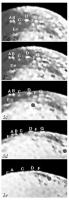
QUOTE (ugordan @ Apr 27 2007, 11:45 AM) Seeing how it appears in Solar System Simulator's map of Iapetus that I always found weird because it practically totally washed out (artificially) contrast and color between dark and bright terrain, it looks clear that it's just a dark patch that was left unprocessed. This idea is further reinforced when one compares that map to Steve Albers' Iapetus map (link) which retains more contrast. The "triangle" there is consistent with the brightness of rest of Cassini Regio. Yes, of course the 'dark triangle' (green) has the same brownish color as Cassini Regio. It seems to be made up of the dark floors of 2 midsized craters. Other dark floored impacts (orange circles) join them in the bright area around. High interesting region to get more information about the origin of the dark material and probably solve this mystery. I marked the 'White peaks/Voyager Mountains' with blue crosses - some of them may be questionable.
And a series of some old Voyager pics showing the peaks at the limb:
I tried to mark them in the part of Steve's map (A-G). Also visible on the map is this old large crater in the west of Cassini Regio I mentioned in post #4 above. It seems to be older than the white peaks inside and thus older than the equatorial ridge of which the peaks are presumably part of. Bye. |
||
|
|
|
||
|
Apr 27 2007, 09:13 PM
Post
#12
|
||
|
Member Group: Members Posts: 288 Joined: 28-September 05 From: Orion arm Member No.: 516 |
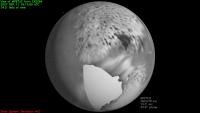
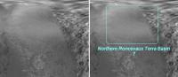
While having a closer look at Steve's map I got aware of a structure not mentioned before as far as I remember:
If it's real it must be the largest basin on Iapetus. The northern part of Roncevaux Terra was imaged in saturnshine, so contrast is rather low and you don't really get aware of its rim compared to that of the basin in eastern Cassini Regio. Bye. |
|
|
|
|
|
|
Apr 28 2007, 10:08 AM
Post
#13
|
||
|
Member Group: Members Posts: 288 Joined: 28-September 05 From: Orion arm Member No.: 516 |
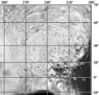
Btw.,
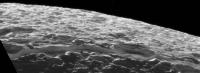
some nomenclature of craters in northern Roncevaux Terra:
All craters are named after characters from the 'The Song of Roland' - the oldest major work of French literature, composed between 1075 and 1110. This link also offers a list of all acting characters - so we've got some names left for all those craters in Roncevaux Terra still unnamed... After Sep.10th IAU will hopefully eventually carry on giving offical iapetean designations. Bye. |
|
|
|
|
|
|
May 5 2007, 03:08 PM
Post
#14
|
|
|
Senior Member Group: Members Posts: 1628 Joined: 5-March 05 From: Boulder, CO Member No.: 184 |
TritonAntares that's an interesting image you are showing in post #12 with the possible basin outlines. I have part of that region on my map, and I wonder if the image you are showing can be filtered enough to remove the glare (if it can add territory to the map).
By the way I've made a new Iapetus map update. Time flies as it's the first update in about 11 months. I was able to refer to Ugordon's image to get my bearings better and the new map has more consistent navigation of the images in the southern portions of the Saturn facing hemisphere (near the edges at zero degrees longitude). I may try making some south polar views to help check/refine things further. http://laps.noaa.gov/albers/sos/sos.html#IAPETUS -------------------- Steve [ my home page and planetary maps page ]
|
|
|
|
|
May 5 2007, 04:29 PM
Post
#15
|
||
|
Member Group: Members Posts: 288 Joined: 28-September 05 From: Orion arm Member No.: 516 |
Hi Steve,
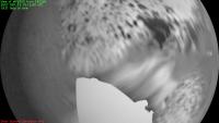
I must admit it was not your map I used for this section of northern Roncevaux Terra... 
Compare these 2 maps: 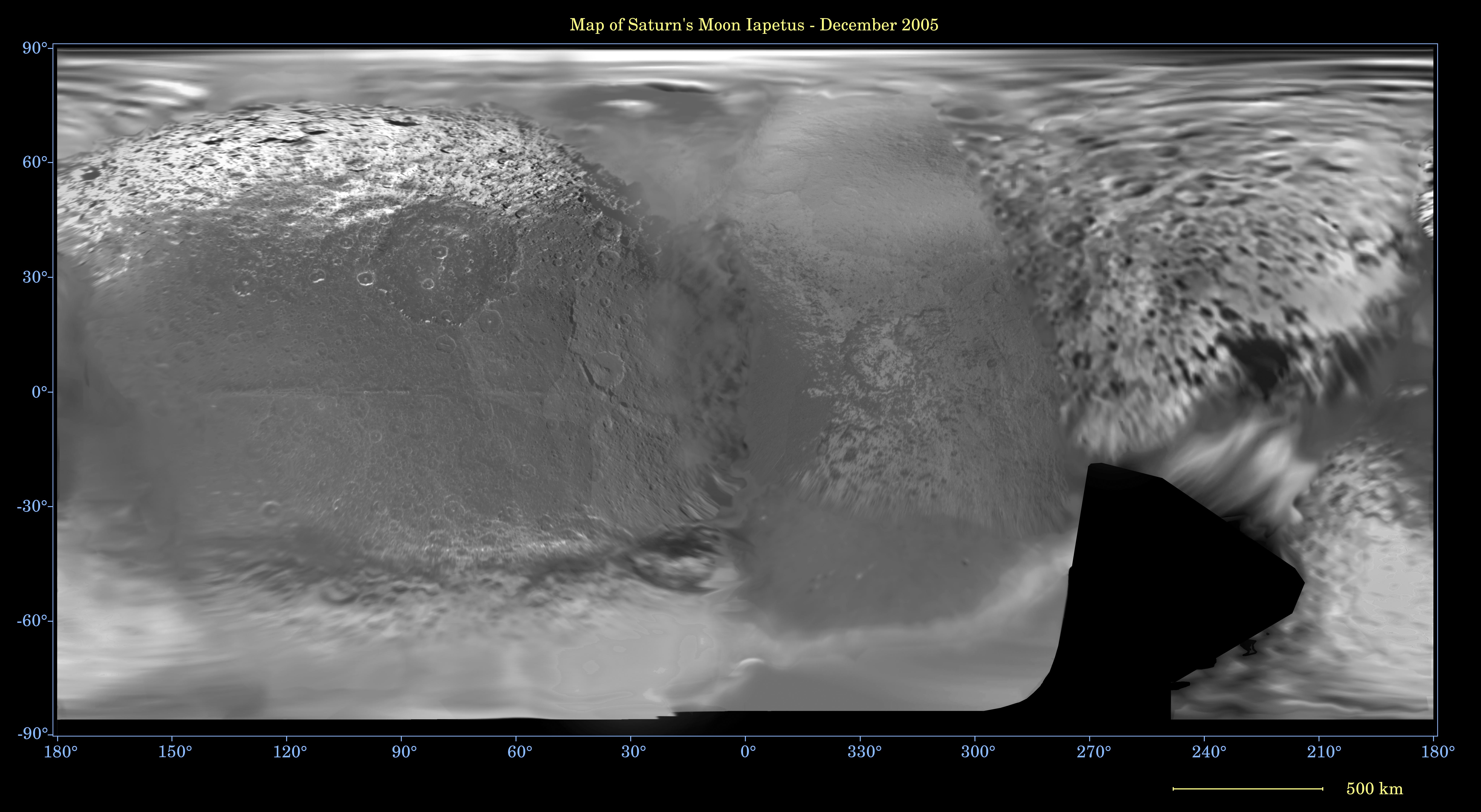  -click to enlarge- Bye. |
|
|
|
|
|
|

|
Lo-Fi Version | Time is now: 26th April 2024 - 06:41 PM |
|
RULES AND GUIDELINES Please read the Forum Rules and Guidelines before posting. IMAGE COPYRIGHT |
OPINIONS AND MODERATION Opinions expressed on UnmannedSpaceflight.com are those of the individual posters and do not necessarily reflect the opinions of UnmannedSpaceflight.com or The Planetary Society. The all-volunteer UnmannedSpaceflight.com moderation team is wholly independent of The Planetary Society. The Planetary Society has no influence over decisions made by the UnmannedSpaceflight.com moderators. |
SUPPORT THE FORUM Unmannedspaceflight.com is funded by the Planetary Society. Please consider supporting our work and many other projects by donating to the Society or becoming a member. |
|