Printable Version of Topic
Click here to view this topic in its original format
Unmanned Spaceflight.com _ MSL _ Curiosity Image Retrieval Tools
Posted by: DEChengst Aug 11 2012, 09:18 AM
I wrote a shell script that allows you to download all images from a given sol.:
http://paranoid.dechengst.nl/files/MSLget.sh
There are two rm commands in the script to clean up the tempdir. If you're afraid my script screws up your system replace them with rm -i commands. If you want any features added please let me know and I'll see what I can do.
EDIT1:
Added leading zeros in the directory names for easy sorting after a request for it on IRC.
EDIT2:
I see a lot of people downloading the script. To be clear: This is a script for *NIX systems and won't run on a standard Windows box. To get it running under Windows you need to install a *NIX environment like Cygwin. Your other option would be to install something like Ubuntu in VirtualBox.
EDIT3:
As RoverDriver pointed out you need to have wget on your system to use this script. The script now handles this gracefully.
Posted by: RoverDriver Aug 11 2012, 01:32 PM

I see a lot of people downloading the script. To be clear: This is a script for *NIX systems and won't run on a standard Windows box. To get it running under Windows you need to install a *NIX environment like Cygwin. Your other option would be to install something like Ubuntu in VirtualBox.
I looked over and this should work also on Macs. Your script relies upon wget being installed on your system which is not always the case. That is the only dependency I see. DEChengst, this is not a criticism, just trying to be helpful to anyone who might try using your script and found a problem. Wget for Mac can be found http://www.macupdate.com/download/33951/wget-1.12-pkg.zip and it is a cool tool that you should get (no pun intended) anyway. I use it all the time to download large stuff, like HiRISE images, DTMs.
Paolo
Posted by: RoverDriver Aug 11 2012, 01:34 PM
As an example of using wget to download the HiRISE images, here's my script that downloads the non-map projecte, the map projected and label files to your current working directory:
echo $1| tr "_" " "|awk '{printf "wget http://hirise-pds.lpl.arizona.edu/download/PDS/EXTRAS/RDR/%s/ORB_%04d00_%04d99/%s_%06d_%04d/%s_%06d_%04d_RED.QLOOK.JP2\n", $1,$2/100,$2/100,$1,$2,$3,$1,$2,$3}' | /bin/sh
echo $1| tr "_" " "|awk '{printf "wget http://hirise-pds.lpl.arizona.edu/download/PDS/EXTRAS/RDR/%s/ORB_%04d00_%04d99/%s_%06d_%04d/%s_%06d_%04d_RED.NOMAP.JP2\n", $1,$2/100,$2/100,$1,$2,$3,$1,$2,$3}' | /bin/sh
echo $1| tr "_" " "|awk '{printf "wget http://hirise-pds.lpl.arizona.edu/PDS/RDR/%s/ORB_%04d00_%04d99/%s_%06d_%04d/%s_%06d_%04d_RED.LBL\n", $1,$2/100,$2/100,$1,$2,$3,$1,$2,$3}' | /bin/sh
Paolo
Posted by: M_Welander Aug 11 2012, 01:52 PM
I've written a small too to help me download the "RAW" Curiosity images from the mars.jpl.nasa.gov site. Originally, I wrote it for my own use, but since some people here might find it useful I thought I should make it public.
The system requirement to run it is .NET 4.0.
It's important to note that this is just a quick and dirty tool I whipped up this morning, so the code quality isn't exactly great. There's not a lot of fault tolerance in the code, for example.
Another thing to keep in mind is that it's dependant on the current appearance of the mars.jpl.nasa.gov site. If that changes significantly, the tool will stop working. If that happens, and there's interest, I will hopefully have time to update the tool to make it work again.
Anyway, here it is, Curiosity RAW Get. It works for me up to Sol 38 data.
|
EDIT:
Since I don't have a web site of my own, I had initially intended to provide public support for the tool on this board, releasing new version here and making sure this post always pointed to the latest version of the software, and handling support in the followup posts.
After all posts related to software were merged into one thread, that is unfortunately no longer possible, so we'll go to plan B instead:
The version included in this post might in a few days or weeks get old. To get new versions or support, contact me off this board through email instead (My email address is included in the About dialog of the program.).
CHANGELOG:
0.16.38 - 2012-09-14
Added subframe support.
0.15.12 - 2012-08-18
Added thumbnail browsing mode.
Added installer.
0.14.10 - 2012-08-16
Added support for the Sol 10 version of the Curiosity web site.
Enabled threaded downloading.
0.13.3 - 2012-08-11
Switched from Microsoft's HTML parser to the HtmlAgilityPack parser.
0.12.3 - 2012-08-11
Fixed a problem where the Microsoft HTML parser didn't return parent element for some elements.
0.11.3 - 2012-08-11
Fixed version dependency on the Microsoft HTML parser.
0.10.3 - 2012-08-11
First release.

Posted by: James Sorenson Aug 11 2012, 02:11 PM
For windows users, I've been using Star Downloader Pro. Its a link leecher that Scans and follows links on webpages based on what filtered file extention you input. Then it filters and downloads them. In this case .jpg files. There is a 30 day free trial to try it out, works like a charm for me, so I bought it.
http://www.stardownloader.com/
Posted by: Marc Aug 11 2012, 02:26 PM
I'm also working in a phyton script that automate big parts of the downlading process, but as I started teaching myself programming the first week of july it won't be so automatic and will require input from the user, at least until I improve my programming skills. The good part is that anyone will be able to use it as python runs in Windows, Linux and Mac.
Posted by: scalbers Aug 11 2012, 02:42 PM
Also a shell script using wget initially mentioned in another thread. Several related posts appear right afterward - might be nice to consolidate in this thread.
MOD NOTE: Good idea- done!
Sounds good - the script is now post #1 by DEChengst in this thread.
Posted by: Pertinax Aug 11 2012, 02:49 PM
I would also suggest the DownloadThemAll plugin for Firefox for those who wish. http://www.downthemall.net/
It is not at powerful as wget, but it has served me well for six to seven years now.
-- Pertinax
Posted by: M_Welander Aug 11 2012, 03:16 PM
Hm... actually... The reason why I posted my tool in a new thread was so that the link to it could be in the first post (and thus easily updated when future versions are released), and then use the rest of the thread for support and change logs (compare this to how other message boards [for example doom9] dealing with software releases work).
Is there any chance we could break this out again into one thread per tool? As it is now, I fear it won't be obvious to anyone using the tool when a new version is released. In fact, the first post in the thread called "Curiosity RAW Get" isn't even about the tool called "Curiosity RAW Get" anymore.
MOD EDIT: Thread title changed to reflect a more general theme. Please don't start threads for each tool; that would rapidly become very difficult for the UMSF all-volunteer admin/mod team to manage.
Posted by: CosmicRocker Aug 11 2012, 04:09 PM
I installed it, but when I try to run it, nothing appears to happen. Actually, not nothing. I get an info window with some disclaimers, but that is it. I have .NET 4.0 running under win7. I tried double-clicking the icon and also running it from a command line.
Do you have any idea what I may be doing wrong?
Posted by: M_Welander Aug 11 2012, 04:20 PM
Okey, that's too bad. I'm afraid supporting the tool in the middle of a generic software thread is too much work for me to manage, instead, so I'll take support off this board instead. I'll update the post to reflect that.
Posted by: CosmicRocker Aug 11 2012, 05:00 PM
It seems that it might be useful to create a subforum under MSL similar to the "Tech, General, and Imagery" section under MER. That would seem to allow for a little more flexibility with regard to specialized topics like specific software applications.
Posted by: Stellingwerff Aug 11 2012, 07:40 PM
I'm building a webportal for easier access to the raw images, but I'm highly time-constrained, so it's going slowly.
But the first step is there:
I've put an automatically up-to-date JSON listing of all RAW images online, as a more convenient listing for (web)developers or as input for wget scripts.
(With the lack of folder listings in the raw-images CDN, I've done the same HTML parsing as all of you:)
You can find the JSON list at: http://msl-raw-images.appspot.com/landing
There are a couple of parameters:
counts -> Only list image counts per sol/camera.
cam -> Only list specific camera
sol -> Only list specific sol
Examples:
http://msl-raw-images.appspot.com/landing?sol=0&cam=MD&counts (will list the count of descent images: 1522)
http://msl-raw-images.appspot.com/landing?sol=1&cam=NRA (will list all right Navcam images for sol 1)
The site will automatically update every 30 minutes, so expect a ~15 minutes delay compared to the original site.
Hope this portal will be usefull already. I'm planning on making a webpage similar to the MER raw images as soon as possible. (hopefully within a day or two)
Greetings,
Ludo.
Posted by: elakdawalla Aug 11 2012, 08:12 PM
On previous missions when it's been tough to parse raw images (Phoenix being a major example) I've posted easier-to-browse indexes on the Society's site. But I'm no programmer; I always did this manually. There appear to be lots of different solutions brewing here. I would LOVE it if when one of these gets fleshed out, it could be dropped in to a subsite on the Planetary Society website. With lots of praise and credit to whomever developed the solution. I can handle making it play nicely with our site, but I can't do automated image retrieval/indexing.
Posted by: M_Welander Aug 11 2012, 08:31 PM
I think it'll be fairly easy to get this "fleshed out". I see mainly two problems:
- First, that the tools need to be able to run on a variety of strange and wonderful systems, which means a lot of compatibility testing to start with. It's not difficult, it just takes time, and for a while the tools will embarrass their programmers with really, really stupid bugs.

- Second, and most important, the tools will need to be constantly updated to reflect any changes in the web sites from which they gather data.
Posted by: jmknapp Aug 11 2012, 08:41 PM
To simply get a list of all the raw images for a given sol, I put up a web widget--access it with wget as follows, for example for sol 4:
wget -O sol4files.txt http://curiositymsl.com/cgi-bin/getfiles.cgi?sol=4
I.e., just set the sol=N parameter and you get a text file back with all the raw images currently on the MSL public web site
For a really basic web interface to same, see:
http://curiositymsl.com/rawlist
Posted by: elakdawalla Aug 11 2012, 10:28 PM
Thanks, this is great! Note that with Navcam and Hazcam images it's indexing thumbnail versions of the raws (*-thm.jpg) whereas with the MSSS cameras the raws are linked directly.
Posted by: jmknapp Aug 12 2012, 12:51 AM
You're right--thanks! It's fixed now.
Posted by: walfy Aug 12 2012, 04:37 AM
Any chance that Midnight Mars Browser can be modified by the code wizards to do the trick for quick MSL downloads? I love that program! It sends photos of each camera to their own folders, even folders for separates sols. Very nice way to keep track. (Crossing fingers).
Posted by: elakdawalla Aug 12 2012, 04:47 AM
Believe me, Mike knows very well we want that, and no amount of pestering will make it more likely to happen (or happen any faster), though compliments are probably always welcome. As with pretty much all of you guys, that isn't his day job. We just have to wait and hope he can find time somehow!
Posted by: elakdawalla Aug 12 2012, 04:49 AM
https://planetary.s3.amazonaws.com/data/msl/raw/msl_raws_thru_sol_0004.zip
Posted by: M_Welander Aug 12 2012, 05:37 AM
That is how Curiosity RAW Get works as well. It also keeps track of the images you've previously downloaded.
Posted by: rtphokie Aug 12 2012, 08:15 PM
Anyone had any luck decoding the filenames on the raw images?
SSSSIICCCCCCCCCCT1_DXXX
SSSS = sol number (good to see 4 digits here)
II = is the instrument (ML = Mastcam left)
CCCCCCCCCC = ????, is this a serial number? It doen't appear to be a time (see below)
T = image size I or E
1_DXXXX = ????
Looking at a couple of examples:
0003ML0000139000I1_DXXX taken at 2012-08-09 06:01:57 UTC
0003ML0000134000I1_DXXX taken at 2012-08-09 05:59:34 UTC
Those timestamps are 2 min 23 seconds apart. the numbers in the filename do not seem to refer to time, Earth or Mars.
Also, some of the mastcam images ending in I1_DXXX also have higher resolution versions ending in E1_DXXX but aren't listed on the mars.jpl.nasa.gov site. Are they listed somewhere else?
Posted by: jmknapp Aug 13 2012, 12:40 AM
Noticed a little bug on the JPL raw images web site--for full frame MAHLI images they show a thumbnail with a link to the full frame image, but it turns out the thumbnail IMG SRC is actually the full frame image. The html code sets the thumbnail width to 160 so it looks like a thumbnail, but it's a waste of bandwidth as all the full frame MAHLI images for a given sol will be downloaded when just looking at the thumbnail page.
Here's an example (MAHLI images with 'E' in the 17th character of the filename are full-frame, 'I' for thumbnail):
Posted by: mcaplinger Aug 13 2012, 12:56 AM
That sounds like a useful bug report, but I have no idea who's in charge of the website. I'll ask around. Maybe Doug knows?
Posted by: jmknapp Aug 13 2012, 01:43 AM
I sent a feedback message under the category "site problem"--we'll see if there's a response. I notice that the same holds true for mastcam images. Most of the mastcam images so far have been thumbnails, but there are a few intermediate ("subframe" 1200x1200) versions which have the non-thumbnail as the IMG SRC. That could be a problem when the big mastcam images start rolling in.
Posted by: elakdawalla Aug 13 2012, 01:45 AM
I reported the same to Veronica McGregor a few days ago (who is not in charge, but obviously can talk to whomever is) and she said that they officially do not care about bandwidth since everything is stored in the cloud. Now, that's fine for them but it'd be better for the user if they didn't have to download so much data. But I don't want to hassle them about this detail since it's the least of our problems with accessing data. If I'm going to bug them I want to bug them about things like getting metadata (filter information, pointing information etc) and faster distribution of the raws hopefully by automating things. As of the time I left JPL, as far as anybody knew it was a manual process. Priorities! Other people have been begging Mike Howard to make a version of MMB for Curiosity. Even if he wanted to, he couldn't right now, because they're not posting enough metadata.
Posted by: mcaplinger Aug 13 2012, 02:18 AM
That's not a useful response IMHO. The camera thumbnails are lovingly antialiased onboard to be as good as they can be at their minimal size, so just tossing them seems really lazy, and it's contributing to make the pages load really slowly even if you have a fast connection.
As for metadata, if I recall correctly this was provided in a separate file for MER. There are no technical barriers to doing the same thing for MSL...
Let me emphasize, just my own opinion and not an official position, etc.
Posted by: Astro0 Aug 13 2012, 03:02 AM
Let's remember that the mission is not obliged to give us access to these image at all. At least until the PDS release.
It's early days in the mission and the priority is the mission.
All of the so-called "issues" with getting quick and easy access to the images will sort itself out in due course.
Remember that we are privileged to get access to this data, but they are not obligated to provide it.
The fact that they do provide it at all is highly appreciated and while frustrating to some that it's not quicker and easier, we need to remember that their people and resources are not unlimited. Give them time.
UMSF is a great place to provide useful suggestions and ways to access the imagery.
It is of no value to complain about it.
Posted by: mcaplinger Aug 13 2012, 03:54 AM
I'm on the camera team and I'll complain about it if I want to, thanks.
That said, this is kind of an interesting article.
http://www.informationweek.com/government/cloud-saas/nasa-mars-mission-fueled-by-amazon-web-s/240005286
Posted by: CosmicRocker Aug 13 2012, 04:06 AM
UPDATE:
I was getting too many strange errors using the Microsoft HTML parser. I've now switched parser. Anyone who's had trouble with earlier versions would do well trying this new one.
Although I had some problems with the first version, the new one (0.13) is working quite well for me. It seems to be a good option for Windows users who want to download MSL images in mass. The application allows you to apply various filters to your selection, and it automatically creates a nice directory structure.
Posted by: djellison Aug 13 2012, 05:03 AM
Michelle Viotti
Posted by: jmknapp Aug 13 2012, 10:28 AM
That said, this is kind of an interesting article.
http://www.informationweek.com/government/cloud-saas/nasa-mars-mission-fueled-by-amazon-web-s/240005286
In this case, the fix is dead simple--the thumbnails do exist. If they just change the 'E' to 'I' in the img src file names they'd be done. Straight bug fix, not a feature request. Until that happens, anyone scraping the web pages for URLs should be aware.
I guess Amazon Web Services would give a big thumbs up to the current situation though!
Posted by: M_Welander Aug 13 2012, 10:54 AM
That's very good to know! I guess that means I can safely enable the threaded downloader in Curiosity RAW Get without risking to hurt their servers, then.
Posted by: algorimancer Aug 13 2012, 02:28 PM
I have my AlgorimancerPG rangefinder/photogrammetry tool updated to work with the MSL navcam images -- I hope to post it to the website tonight (it's not there yet). I'll announce the availability here when I do (this seems the closest topic match in the MSL section).
One thing it is lacking is the correct sol/time calculation; it will display a value, but it's not going to be a correct value. If someone could clarify how to get the sol/time from the image title, that would be much appreciated.
Another thing lacking is camera orientation. For MER, this could be obtained from the Pancam Tracking Database. I'm not aware of any such database as yet for MSL.
Support for the Mastcam's higher resolution cameras may or may not happen for MSL, as this will require rather more time than I happen to have at the moment. If there's someone with experience programming with Microsoft Visual C++ (Visual Studio 2010 professional) who would like to take-on the project, particularly someone familiar with imagery and vectors and quaternion transformations, I would be happy to share the code. This may take anywhere from a few days to a couple of weeks of programming time. Considering that we have high resolution images and topography from orbiters already, I'm not sure there would be much value in adding Mastcam capability, but it is an option.
Posted by: mcaplinger Aug 13 2012, 03:14 PM
Another thing lacking is camera orientation. For MER, this could be obtained from the Pancam Tracking Database. I'm not aware of any such database as yet for MSL.
For Navcam the file name has the SCLK value for the image time, I think. For MMM it appears there is no SCLK in the filename and metadata would be needed to figure out the time. I'm not sure what the time on the raw image website means, I haven't tried to correlate it.
The NAIF website (http://naif.jpl.nasa.gov/naif/data_mars.html) has some information about how to map SCLK to UT and LMST and may be a source for pointing data (I'm not sure what the CK files there look like or what their plan is to update it.)
Posted by: ugordan Aug 13 2012, 03:41 PM
I think it's just SCET.
Posted by: jmknapp Aug 13 2012, 03:44 PM
I've checked it--for example the website has http://mars.jpl.nasa.gov/msl/multimedia/raw/?rawid=FLA_397506083EDR_F0010008AUT_04096M_&s=0 with a time of 2012-08-06 06:23:34 UTC.
From the file name, the et is 397506083, which according to et2utc_c() translates to 2012 AUG 06 06:20:16 UTC. So there's a discrepancy of about three minutes (3:18). Possibly related to processing on the rover?
Just for another example, here's one from sol 2, http://mars.jpl.nasa.gov/msl/multimedia/raw/?rawid=NLA_397682534EDR_F0020000AUT_04096M_&s=2--the date given is 2012-08-08 07:24:27 UTC and 397682534 translates to 2012 AUG 08 07:21:07 UTC, similarly a 3:20 difference.
Posted by: mcaplinger Aug 13 2012, 04:18 PM
My guess is that this is not ET but SCLK, which drifts from ET. You need to use scs2e (or sct2e) to get this into ET.
Posted by: algorimancer Aug 13 2012, 04:44 PM
Thank you, I think that did the trick.
EDIT: I've run into some difficulties with the installer (upgrading the development environment from VS 2005 to VS 2010 has been a real headache). Hopefully I'll be able to fix it tomorrow and get it posted.
Posted by: jmknapp Aug 13 2012, 06:07 PM
Sounds reasonable--but isn't SCLK measured in 'ticks'?
Posted by: mcaplinger Aug 13 2012, 06:28 PM
You don't get the subseconds in the filename, so you will be off by a second minus a tick worst-case.
Posted by: jmknapp Aug 14 2012, 12:17 AM
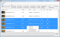
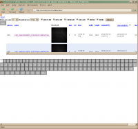
Trying to develop a handier web interface to the raw images, here's a first go if anyone would like to help beta test it:
http://curiositymsl.com/table/view
It shows the raw images in table form, sortable by date taken, release date, etc. by clicking on the column headers. The default sort, by release date, is the handiest I think, since it shows the most recent uploads to the JPL site. It's hard otherwise to keep track of the newest files because they can come in under any sol.
Open to suggestions as to how it could be more useful. One thing that comes to mind is to be able to filter by camera, because with all the images in one big list, there are a lot of pages, mostly due to the large number of MARDI images.
Posted by: elakdawalla Aug 14 2012, 12:40 AM
First: AWESOME!
It would be great to filter by camera.
I think image dimensions would be more useful than file size.
I'm amused by the "lag" column, though it's not exactly fair, since it folds in both transmission lag (when did it arrive on Earth?) and raw posting lag.
I'd prefer smaller thumbnails and more images per page, but don't know if that opinion is shared.
This takes more logic, but: it would be great if it did not show *both* thumbnails *and* fulls of the same image. It would be lovely if it could just show the highest-resolution one returned to Earth so far.
Posted by: Oersted Aug 14 2012, 12:44 AM
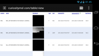
Works great on a Samsung Galaxy Nexus smartphone, for what its worth... -Excellent job!
|
Posted by: lyford Aug 14 2012, 12:58 AM
Allow me to say OMAGERD THANK YOU 
Posted by: RoverDriver Aug 14 2012, 01:18 AM
http://curiositymsl.com/table/view
It shows the raw images in table form, sortable by date taken, release date, etc. by clicking on the column headers. The default sort, by release date, is the handiest I think, since it shows the most recent uploads to the JPL site. It's hard otherwise to keep track of the newest files because they can come in under any sol.
Open to suggestions as to how it could be more useful. One thing that comes to mind is to be able to filter by camera, because with all the images in one big list, there are a lot of pages, mostly due to the large number of MARDI images.
Joe, you are an incredible source of amazing products! You asked for some suggestions, here they are:
1) yes selecting by camera would be great and probably necessary at some point in the mission
2) the dialog at the bottom with the sol numbers should be at the top in a separate, static frame so you can jump to any given sol without having to go to the top or bottom.
3) the dialog dialog box with the sol number should highlight the sol with the most recent images available.
4) if at some point in time they will make the image header available, or get telemetry for each image I suggest that the image name be a link to the telemetry.
One question: why keeping track of when the image was received and, most notably, why keeping track of the "lag"? I'm not sure we keep track of that, but if there is a reason I would like to know and do it as well. Never stop learning!
Paolo
Posted by: jmknapp Aug 14 2012, 01:20 AM
True, that was just a matter of expediency. I can find out the size of the files remotely with a "curl -sI <url>" command, but to get the image dimensions I would need to download all the files as they come in. That could be done.
Haha, I thought that was potentially snarky too, but still, it's of interest to know how "live" the images are. There was a press conference last week where a guy from "Nasa Watch" was insinuating that if they happened to find a picture of stromatolites they would withhold it (which Dr. Grotzinger of course denied). Anyway, looking at earth-shattering photos like http://mars.jpl.nasa.gov/msl-raw-images/proj/msl/redops/ods/surface/sol/00001/opgs/edr/ncam/NRA_397586934EDR_F0010008AUT_04096M_.JPG which was "withheld" for almost a week, it would seem that real life is less intriguing.
Thanks for the other good suggestions.
Posted by: jmknapp Aug 14 2012, 01:46 AM
I'm thinking maybe some check boxes at he top for each camera to be included (not 17 check boxes, but 1 for each major type!).
3) the dialog dialog box with the sol number should highlight the sol with the most recent images available.
The navigation buttons do seem inconvenient down there. Note that they are simply page numbers, not sol numbers (20 entries per page).
Absolutely--did they ever do that for MER?
No pressing reason for tracking the lag other than I thought it might be interesting to see a pattern--see reply above. I realize a lot of time is spent waiting in the relay queue.
Posted by: ChrisC Aug 14 2012, 02:12 AM
Fantastic, Joe!
My one suggestion has to do with the curiositymsl.com home page. Please either A) link to the basic index page from there, or  configure your site to automatically forward to the index page. That way I just have to remember "curiositymsl.com" when I get inspired to check for new images, no matter what computer I'm at.
Of course, I can navigate to UMSF, find this thread, click to the right page, and then click the link, but ...
Posted by: volcanopele Aug 14 2012, 02:29 AM
I have to concur, on my iPad. So much easier to look at and find images than the official site, which currently forces tablet users to the smartphone version of the site.
Posted by: mcaplinger Aug 14 2012, 02:33 AM
In some cases the image is only partially received on the ground the first time around and retransmissions have to be commanded. That can slow things up, sometimes considerably. Also, images can be prioritized low and get stuck behind higher-priority data. I seem to recall images showing up weeks or even months after acquisition on MER. So the lag is pretty meaningless.
Posted by: RoverDriver Aug 14 2012, 02:36 AM
The navigation buttons do seem inconvenient down there. Note that they are simply page numbers, not sol numbers (20 entries per page).
In that case, I suggest having the possibility of selecting single Sols.
...
Yes, I don't know how UMSF people get MER telemetry but some limited telemetry is available. At least the vehicle position and attitude at time of image capture. Sometimes I wonder what UMSF-ers would be able to do if the full MER (and MSL) telemetry would be made available.
Paolo
Posted by: Cargo Cult Aug 14 2012, 06:52 AM
Evening, all -
It's definitely not a fantastically useful image-listing tool like those above, but in keeping with the scraping-NASA-sites-to-present-data-in-more-versatile-ways theme, I've created a supremely unofficial RSS feed for the http://mars.jpl.nasa.gov/blogs/ blog.
It's at https://hylobatidae.org/misc/msl_blog.php - I haven't had a chance to test it in Google Reader, but it seems to work okay in Safari and Vienna for Mac OS X. It'll automatically check for updates every hour. Let me know if you have any issues!
(It's a horrible hack, derived from my equally unofficial RSS feed for Astronomy Picture of the Day: https://hylobatidae.org/misc/apod.php. They were built for my own use, but I hope people find them in some way helpful. Now, back to lurking on this fascinating forum! ;-) )
Posted by: Explorer1 Aug 14 2012, 07:52 AM
It works on my end; good job!
It's always a little strange when totally unrelated hobbies collide...
Posted by: algorimancer Aug 14 2012, 03:14 PM
The AlgorimancerPG (APG) rangefinder utility is updated for Curiosity,
http://clarkandersen.com/RangeFinder.htm
I think I have the installer problem fixed, but don't happen to have another computer to test it on, so if someone would like to download/install/test it on a stereo pair of MSL navcam images, it would be appreciated.
The update only adds capability to do distances/photogrammetry with MSL's navigation camera images, and lacks any information about orientation since that database has not been made available as yet. I'm not too worked-up about adding support for the higher resolution Mastcam images, as it would take a lot of programming effort and I'm not clear on what real benefit it would offer -- sure, it would allow rangefinding out to much greater distances, but we have Hirise images already for that sort of thing. I may be susceptible to persuasion, given a good motivation.
Incidentally, loving the table view (http://curiositymsl.com/table/view).
Posted by: fredk Aug 14 2012, 03:30 PM
Your site is already looking fantastic, Joe. I've got a few suggestions based on years of MER jpl and exploratorium use.
MER jpl is nice in that it sorts by sol, which is crucial when trying to find older images. Exploratorium is great because it sorts by arrival/release time, which is crucial when you're regularly looking at the latest images. So definitely the ability to sort either by sol or release time would make this the single best source of MSL images.
I agree with Emily that thumbs should be tossed out when superceeded by higher resolution images (though perhaps the official thumbs from Mars could be used as the image thumbs on your site, if the size is right?). It's odd that the MSL jpl site doesn't do that.
Another crucial feature of both MER jpl and exploratorium interfaces is that they indicate visited image links (ie visited links change colour). This makes it so much easier to catch up with images once a day or whenever you like, without having to remember which pics you've already looked at, especially when you sort by sols. One suggestion would be a border around the image thumb that changes from unvisited to visited colour, like with the MER jpl site.
Posted by: stevesliva Aug 14 2012, 03:53 PM
Nice! Some others that either have wonky feeds, or none at all would be MESSENGER and Dawn:
http://messenger.jhuapl.edu/gallery/sciencePhotos/
http://dawn.jpl.nasa.gov/multimedia/imageoftheday/archives.asp?month=2012-August
(Aren't those such interesting pages you might want a feed from? For your own use?
)I've just used feedity.com in the past, but it's definitely not as useful as an actual human...
Posted by: mhoward Aug 14 2012, 04:31 PM
I'm glad that the MSL jpl site is posting the thumbnails, this is actually good and I hope they keep it that way. The rover thumbnails are distinct from web thumbnails; they are really a distinct image category of their own. For example on MER, the ETH is always full-frame, while the full returned image may be subframed; so in that case the ETH thumbnail is never completely supplanted by the full image.
That said, sure it makes sense not to show them on a secondary site if they've been supplanted by a full image. But for the source of all our images? Please keep 'em.
Posted by: elakdawalla Aug 14 2012, 04:44 PM
MESSENGER has a feed of sorts -- through its iPhone app. I get a notification every time they post a new image. I actually like their iOS gallery browser better than their Web image browser, which I find pretty clunky.
Posted by: jmknapp Aug 14 2012, 07:07 PM
OK, lots of good suggestions, I'll get to most of them as I have time. For now I just made a fewchanges--
1) image width and height is now given instead of file size
2) added a sortable column for sol number
3) the top level domain http://curiositymsl.com now goes to the table so there's no need to add the table/view part
I'm trying to keep it simple from an ongoing maintenance angle, so it just checks the JPL website every 15 minutes for new images and just adds them to the db as it finds them. Therefore, the "official" thumbnails get treated just like any other image. Weeding out the database manually is a non-starter, but maybe some automated way would work, like if a full-frame image comes in, change the file name to the thumb version and nuke the latter if it's is in the db. But then the next time it checks for updates it would have to know not to flag thumbs as new files. So rather than deleting, maybe the db needs a "visibility" flag for each file. And so on...
Posted by: Stellingwerff Aug 14 2012, 07:41 PM
Hi all,
In the meantime my listing has also evolved, a first listing can be found at:
http://msl-raw-images.appspot.com/lists.html
Lots to do and some work-arounds to get it faster online, with the most noticeable the "spartan" camera selection. (currently you need to list all camera's in a comma seperated list, empty list leads to all cameras selected!)
I think it's somewhat usefull by now. Stay tuned for many new features in the coming week(s). Yes, I am planning on picking up many of the tips you've mentioned to Joe and integrate those into my version as well.
Greetings,
Ludo.
Posted by: elakdawalla Aug 14 2012, 08:44 PM
Oh, cool. Hopefully you two guys' solutions will be divergent, so each will have its distinct uses.
Posted by: walfy Aug 14 2012, 09:16 PM
http://msl-raw-images.appspot.com/lists.html
This is very nice! Thank you. In my limited knowledge of all the possibilities out there to make easy the downloading process, I found your page very easy to set the parameters of which files I wanted, then along with the https://addons.mozilla.org/en-US/firefox/addon/downthemall/ FireFox add-on, I could download all the images to any folder on my hard drive in one fell swoop. A great thing about DownThemAll! is that it's freeware and also can be set to skip over files already downloaded. So that's nice for checking for updates.
For example, I wanted all the full-res files from only Sol 3 to download them in their own folder, and setting it up was very easily for that (had to make sure I kept clicking the "show all" button below the list as it resets itself after each setting of filters and goes back to showing only a partial list of images). Later I will see if I can separate them out by camera. (Can't believe how many cameras there are!)
Thanks again.
Posted by: algorimancer Aug 15 2012, 12:11 AM
http://clarkandersen.com/RangeFinder.htm
I think I have the installer problem fixed....
It turns-out the installer problem is not quite fixed. The executable link installed under Start/Programs Menu works, but can't find the associated DLL file. However, if you navigate to the c:/Program Files/AlgorimancerPG directory (or wherever you opted to install the application), double-clicking on AlgorimancerPG.exe from that location works fine.
This was my first attempt at having the installer put a link in the Programs Menu area, and clearly I have not mastered the trick. I'm guessing that I need to somehow provide a direct link to the DLL, perhaps through the registry, or perhaps simply have a copy of the DLL installed in the Programs Menu area; I'll have that sorted in the next few days. Meanwhile, the rangefinder application is useable, but you might want to map your own shortcut to the executable.
Just at the moment, only the navcams from Sol 2 are really of interest -- this will of course change once driving commences. One problem with the MSL image naming system is that left/right image pairs tend to be separated by rather a lot when sorted alphabetically -- perhaps this could be compensated for in the posted image browser tools to make it easier to pair them together? It would take some minimally creative sorting.
For those new to the APG utility, be sure to grab only the full-frame navcam image pairs, as it doesn't work with thumbnails or subsampled images.
Posted by: jmknapp Aug 15 2012, 02:18 AM
Hey, good news and bad news, the good outweighing the bad. It seems that just a little while ago JPL revamped their raw image website. They fixed the issue where full size "thumbnails" were being loaded. They also flag the latest images ("The 5 new images for Sol 3 are marked with a red *") as well as images grouped by camera.
The bad news is that with the changes in their html, page-scraping for my app is broken for the time being & I turned off updates until that can be fixed. Always a danger with hacks like page-scraping!
Anyway, the main site is on move.
Posted by: ElkGroveDan Aug 15 2012, 02:46 AM
This is very atypical for JPL, normally they are right on top of things I would think this should have been all hashed out six months ago. Anyone know who is responsible for the new website?
Posted by: djellison Aug 15 2012, 03:02 AM
Mars EPO - headed by Michelle Viotti
Posted by: Stellingwerff Aug 15 2012, 03:46 AM
Anyway, the main site is on move.
Good! Although following a moving target is challenging, any progress on their side is excellent. Happily they decided in this "round" to keep their old "sol-based" page largely similar, so my HTML loading still works correctly. (Largely similar doesn't mean that they didn't hasitate to put another 30.000+ empty lines in the HTML!)
Let's see where they are moving towards, I hope they are reading the user-feedback on this thread as usefull input:)
Greetings,
Ludo.
Posted by: jcims Aug 15 2012, 05:39 AM
Does anyone in here know if any metadata is available for the images? E.g. elevation, heading, exposure, location, etc? I thought this was available for the MER raw images a while ago, but I couldn't find anything lately.
Posted by: elakdawalla Aug 15 2012, 05:41 AM
It's a big improvement! Now we just need the metadata that'll help all you mosaic-assemblers (*cough*ahem*Mike*) automate the building of panoramas.
But I'm ready for one of you guys to write us an auto-raw-downloader that'll replicate at least that function and maybe the slideshow mode, if not the panorama mode, of MMB 
We ran into a similar weird whitespace problem on the Planetary Society website about 9 years ago. We noticed slow page download times and I realized our home page (which was then coded in Dreamweaver, I think, but I stubbornly insisted on hand-coding) had bloated to the horrifying size of 900k with huge amounts of whitespace. A little searching led me to a known issue where there was some problem that happened with transferring text files between unix systems and either Macs or PCs (I don't remember which) where each line feed was replaced with a CR-LF going one way, and then when the file was downloaded again the CR and LF were each replaced with a line feed, resulting in a doubling of the amount of white space each time the file was uploaded and re-downloaded. Since there were several different people who might edit the home page in a given day, who downloaded the current one and re-uploaded it each time, exponential growth happened rapidly.
Posted by: Stellingwerff Aug 15 2012, 07:24 AM
Just a quick update notice:
http://msl-raw-images.appspot.com/lists.html
has been updated with the following changes:
- Filter settings are now kept over page reloads
- "Show All" is now persistent, will not fall back to paging unless "Show less" is clicked
- A camera multiselect is added, empty means "all cameras"
Posted by: jmknapp Aug 15 2012, 11:14 AM
My parsing was a bit more fragile--it's fixed now though and updating again http://curiositymsl.com. I also made a change to hide official thumbnail images where a full-frame image has also come in. Turns out that's about 10% of the total images (right now 1,998 total images).
Nice app!--Google appengine, right? I guess the only thing my app adds is the ability to sort by release date and time taken. BTW, if you're interested in adding that, you can use curl to get the timestamps of the image files on the JPL site, and the time taken on Mars can be scraped from the web pages or with some of the cameras extracted from the image file name (in ephemeris seconds). Maybe some future update on the JPL site will include more metadata and in a more robust form as Emily, Paolo & others have wished for. I imagine it's a bigger problem getting accurate position and pointing info from rovers than with missions such as Cassini. At least in the latter case, Mr. Kepler is largely in control of the positioning without the added complications of terrain, slip and dead reckoning.
Posted by: vk3ukf Aug 15 2012, 11:39 AM
Hi all,
this doc might help help those looking to decode the image file names a little bit.
It's regarding the sclk breakdown.
http://naif.jpl.nasa.gov/pub/naif/MSL/kernels/sclk/msl.tsc
I've been looking for the full MSL EDR SIS file name definition for ages.
I saw further back there, a fellow (rtphokie), piecing it together, thanks for what you've figured out so far.
The MER version,
<scid><inst><sclk><prod><site><pos><seq><eye><filt><who><ver><ext>
(above from, http://pds-imaging.jpl.nasa.gov/documentation/MER_camsis_v4_9-25-07.pdf)
and this is a great straight forward page for the MER EDR SIS,
http://marsrover.nasa.gov/gallery/edr_filename_key.html.
For the Phoenix lander PHX EDR SIS, this the pdf to read,
http://pds-geosciences.wustl.edu/missions/phoenix/phxCamSis.pdf
MPF and Viking links escape me at the moment.
They were a bit odd by today's standards, short file names and part of the sclk string was the storage directories name.
If anyone knows if MSL EDR SIS is online somewhere yet, love to read it.
Any further pointers greatly appreciated.
Perhaps it will appear at the Analysts Notebook, early next year, hopefully before then.
Kevin. Werribee.
Posted by: Stellingwerff Aug 15 2012, 12:03 PM
Thanks for the compliment! Yes, it's a GAE based server, scraping the HTML, building a graph database of the images and then providing this data through a JSON API. (I hope to create some more APIs, like RSS and notifications)
The frontend is HTML5 stuff, taking the JSON and using pure.js (see: http://beebole.com/pure/) to generate the listing, including filtering and ordering.
The applications source-code is available at: https://github.com/ludost/msl-raw-images
The graph database I use (and created) is open-source, see: https://github.com/almende/memo-nodes, one day it will be good enough for broader use...
I've chosen to use my graph db in-between to give this hobby project also some "use" for my work. I also hope to put some more structure in there for determining "stereo" images, some statistics (graphs), etc.
I'm looking into getting some timeinfo in the application. I just need to modify my HTML scraper to work somewhat multi-line:) I did notice that there is a whole world out there for time and location interpretation(SPICE @NAIF). There is however no real JAVA implementation of that toolset. (JNI won't work on GAE) I guess the more MMB-like, advanced features will be hard to achieve on GAE:(
[Edit: If somebody does know a Java implementation that can work with NAIF data, please let me know! Hack, why not a JavaScript implementation:) ]
Greetings,
Ludo.
Posted by: jmknapp Aug 15 2012, 12:25 PM
I think they announced an alpha Java front-end to CSPICE a while back, not sure where that's at right now or where to get it. Here's some documentation though:
ftp://naif.jpl.nasa.gov/pub/naif/misc/tmp/html/JNITspice/src/JNISpice/index.html
FWIW, to date there isn't any rover pointing info available in the MSL SPICE kernels.
Posted by: Stellingwerff Aug 15 2012, 08:14 PM
Hi all,
Another update, starting to get there:)
- Added the date/time from the JPL website, sorting on that column (=stereo images closer together)
- Reload button
- Social/sharing widget
- Styling (background can be switched off!)
This would be a good version to check-out.
What would the next "killer-feature" be? (image counts, sorting selection, file exports, stereo image bundeling, something else?)
Link: http://msl-raw-images.appspot.com/lists.html
Greetings,
Ludo.
Posted by: elakdawalla Aug 15 2012, 10:05 PM
This is awesome. Since you asked, the "killer app" would be the ability to tick checkboxes next to images of interest and then click one button to download them all. Not sure how that would work since you're not actually hosting the images but it's what I love best about the PDS Rings Node's OPUS search tool. Next best thing would be to tick checkboxes and click one button that would spit out a text listing of the full URLs to the selected images, which I could then get with wget.
I never run out of feature ideas Good thing I'm not actually a programmer, I'd only produce bloatware that never got to market.
Posted by: RoverDriver Aug 15 2012, 11:32 PM
If I may suggest something, I think it would be critical to also have a database linking specific features and observations to specific documentation images. You have no idea of how many hours I have spent on MER trying to track images pertaining certain events because I did not have them indexed. With a larger science package and longer expected mission duration it will be a nightmare to keep everything organized on MSL.
Things I had been asked to trace were:
1) when was the first/last time some activity happened
2) how many timed did we do some activity
3) when did a specific event/anomaly happened
4) when was the anomaly resolved or a workaround put in place
5) find where and when did we cross a specific type of terrain
6) do we have images of a specific feature/location
These sort of things and you can extrapolate similar queries from the science perspective. Unfortunately, I'm not really a database guy so I do not have specific suggestions on how to handle this, but the sooner we start keeping track of things the better we are off. Even if later on we need to transition to other methods or architectures I think it is best
to start doing something now. What do you guys (and gals) think?
Paolo
Posted by: Reckless Aug 15 2012, 11:53 PM
This retrieval system is great but for me the links to B & W images (nav cams etc) don't work I get an error message XML has no style information.
any idea if I've got my settings wrong.
Roy F
Posted by: jmknapp Aug 16 2012, 12:31 AM
I added an RSS feed for the latest released images. Click on the  icon at the top of the image listing
http://curiositymsl.com
Posted by: algorimancer Aug 16 2012, 12:58 AM
...
What would the next "killer-feature" be? (image counts, sorting selection, file exports, stereo image bundeling, something else?)
I like it a lot. One thing I think would be nice to add would be to select by camera type --- that is, for navcam, show both L & R images from navcam, rather than selecting just L navcam or R navcam. Likewise for Mastcam.
Posted by: algorimancer Aug 16 2012, 01:08 AM
I posted an update (http://www.clarkandersen.com/RangeFinder.htm%20), which mostly fixes the installer problem with the last version -- the link to APG under Start/Programs Menu now successfully starts the program since I included the associated DLL in that location, but it still throws-up an error message because it's missing the MER image database (so I'll need to install a copy in the same location to fix that), but this has no bearing on images from MSL, just irritating. I'm sure there's a more efficient solution, but I'm no Installer guru -- these days my VC++ skills are atrophying as I spend most of my time with R. You might be happier with your own shortcut to the Program Files directory version of the executable, since it won't throw-up a warning message.
Posted by: jmknapp Aug 16 2012, 09:21 AM
Since that requires a lot of analysis and input by people, the first thing that comes to mind is some kind of photo-tagging system a la flickr. It's a lot of work to come up with meaningful and comprehensive tags, so crowdsourcing would be the way to go? Of course then there's the issue of consistency, etc.
I thought it was a little surprising how JPL described the process of the team mapping the quadrangles (like "Yellowknife"). They said they farmed out the quadrangles individually to "volunteers" who marked up the various kinds of terrain. For one thing, why "volunteers" rather than just a team tasked to do that job? Also, wouldn't there be inconsistency in how people interpret the HiRISE images? But I guess such crowdsourcing works, given a population of motivated people.
Posted by: MahFL Aug 16 2012, 10:04 AM
My impression was they gave the task to "scientists" who at that point did not have much to do.............
As for inconsistancy, thats why you have a Chief Project Scientist, he has the final say.....
Posted by: RoverDriver Aug 16 2012, 10:56 AM
As for inconsistancy, thats why you have a Chief Project Scientist, he has the final say.....
That is exactly it. I'm not sure what the instructions were but the idea was to look at interesting features in each quadrant.
Paolo
Posted by: Stellingwerff Aug 16 2012, 02:41 PM
Somebody will have to talk with the MSL website people, their Sol=0 page is now >150.000 lines long and still growing. (>1.5MB text by now) I'm running into severe problems parsing the document in an automated system.....
Anyway, Sol 10 pictures have arrived, including chem-cam images!
grz,
Ludo.
Posted by: elakdawalla Aug 16 2012, 04:03 PM
I thought it was a little surprising how JPL described the process of the team mapping the quadrangles (like "Yellowknife"). They said they farmed out the quadrangles individually to "volunteers" who marked up the various kinds of terrain. For one thing, why "volunteers" rather than just a team tasked to do that job? Also, wouldn't there be inconsistency in how people interpret the HiRISE images? But I guess such crowdsourcing works, given a population of motivated people.
Since the image filenames do not contain sequence IDs, I was thinking there would need to be some crowdsourced way of grouping images together. It would also be nice to be able to tag images with specific named targets or features as we learn them. This sounds complicated to develop though; it's somewhere between a database and a wiki.
Regarding the mapping, it's a familiar activity to a group of geologists -- you do it professionally, you start doing it in field camp while you're still a student, to divvy up a region into quads and then individuals map their quads and then they put the map together after and then they fight about their identifications. Grotzinger told me he was pleased with how much agreement there was between adjacent quads after this activity was over. One thing it does is makes sure that each area has been really closely examined by somebody; each neighborhood has a local guide.
I've sent an email to Michelle Viotti about the whitespace problem; I'll let you know if she responds.
Posted by: maschnitz Aug 16 2012, 07:47 PM
Emily, if you're in contact with Michelle, could you ask her to put the time in to the Last Updated notice on the raws page? This one: "Last Updated: 08/16/2012 UTC". It's a little hard to tell when new images dropped. You have to memorize the count of images last time, instead.
I figure it's more constructive for one person to deliver requests than all of us to pile on the poor lady. Of course, don't let me nominate you for this if you don't want to do it.
Posted by: mhoward Aug 16 2012, 08:05 PM
Perhaps obvious, but this would be another area where metadata would be useful. Surely the data exists to tie the MSSS rawids to timecode, observation ID, observation description, et cetra; we just don't have access to it.
Posted by: imipak Aug 16 2012, 08:17 PM
An early science crowdsourcing experiment/project tackled crater-counting on Mars... ( https://en.wikipedia.org/wiki/Clickworkers#Identifying_Martian_craters )
Galaxy Quest tackles the consistency problem with a tutorial and tests that must be passed before a volunteer can tackle real data: http://www.galaxyzoo.org/how_to_take_part .
Posted by: elakdawalla Aug 16 2012, 08:34 PM
Yes, indeed. I'm trying not to be a pest; I may try again to bring up metadata next week. The overhaul of the page design and the much faster posting of images are two major improvements made this week; I don't want to be too demanding
Ludo, she says the technical people are looking in to the whitespace problem.
Posted by: Stellingwerff Aug 16 2012, 08:41 PM
Hi all,
In part due to the huge sol=0 page (currently 250.000+ lines) and in part through bugs/issues I created, my app currently is "intermitted".... I'm working on it!
The good news is: As soon as I have the performance issues fixed, I'll have image release dates in the app as well, including sorting. Which means you can easily see what's new.
Grz,
Ludo.
Posted by: Stellingwerff Aug 16 2012, 11:22 PM
Ok, definitely not happy with the performance (and degradation thereof if something goes wrong) but at least it works again.
New features:
- New image filter (<24 hours ago released)
- Show and sort by release date
- Show date in local timezone or UTC
Posted by: 3d_mars Aug 17 2012, 03:59 AM
First post. Here's a small script I wrote to automatically process left and right full frame Navcam image pairs into SBS stereoscopic images. Thanks go to jmknapp for his image list service, http://curiositymsl.com. I originally intended to automate the full process, from downloading the images to creating the final SBS output, but then I realized that I may want to process the images a bit before the final step. I use the free http://stereo.jpn.org/eng/stphmkr/ to create the final images. It's a windows app which is why I chose to write this in http://www.autoitscript.com/site/autoit/ (also free).
BTW, the images are PHENOMENAL when viewed with the http://store.sony.com/webapp/wcs/stores/servlet/ProductDisplay?catalogId=10551&storeId=10151&langId=-1&partNumber=HMZT1. I purchased this hardware a few months ago in anticipation of this mission (and other 3D applications), and I've been extremely pleased with the quality of the high contrast dual OLED displays, which present a ghost-free stereo image.
#include <Array.au3> ; for _arraydisplay
; 20120816, version 0.1
; This script processes all full frame Navcam images using jmknapp's http://curiositymsl.com, downloads only full frame LR pairs
(if not downloaded already) and creates a StereoPhoto script file
; (todo) Also process Mastcam images
; 3d_mars
; prompt user for sol number to retrieve, $sol
Local $sol = InputBox("Sol Number", "Input Sol Number:")
If @error Then Exit
; create temp file for listing all URLs for a given sol
; example: c:\users\username\appdata\local\temp\URLs_sol_1.txt
$URL_list_file=@TempDir & "\URLs_sol_" & $sol & ".txt"
; download image URL list to text file
; InetGet option syntax: URL, filename, 1=force reload, 0=wait for download
InetGet("http://curiositymsl.com/cgi-bin/getfiles.cgi?sol=" & $sol, $URL_list_file,1,0)
; read URL list and import to array
; note: $allURLs[0] contains the number of records read into the array.
Local $allURLs
If Not _FileReadToArray($URL_list_file, $allURLs) Then
MsgBox(4096, "Error", " Error importing from file to Array error:" & @error)
Exit
EndIf
; search for Navcam full frames (*EDR_F*) insert into new array $allframes
; Navcam full frame example URLs:
; http://mars.jpl.nasa.gov/msl-raw-images/proj/msl/redops/ods/surface/sol/00002/opgs/edr/ncam/NLA_397682493EDR_F0020000AUT_04096M_.JPG
; http://mars.jpl.nasa.gov/msl-raw-images/proj/msl/redops/ods/surface/sol/00002/opgs/edr/ncam/NRA_397682428EDR_F0020000AUT_04096M_.JPG
; declare large array instead of resizing array multiple times, uses very little RAM
Local $allframes[9999]=[0]
$x = 1
For $URL in $allURLs
;check for Navcam full frame
If StringInStr($URL,"EDR_F") Then
$allframes[$x]=$URL
$x += 1
EndIf
Next
;record total number of frames
$allframes[0]=$x - 1
; read allframes to find matching left/right pairs
; insert into new arrays $leftframe_Nav, $rightframe_Nav
Local $leftframe_Nav[9999]=[0]
Local $rightframe_Nav[9999]=[0]
Local $leftframe_counter = 0
Local $rightframe_counter = 0
For $x = 1 to $allframes[0]
If StringInStr($allframes[$x],"NLA_") Then
;left frame found, store in $leftframe_Nav array
$leftframe_counter += 1
$leftframe_Nav[$leftframe_counter]=$allframes[$x]
$leftframe_Nav[0]=$leftframe_counter
ElseIf StringInStr($allframes[$x],"NRA_") Then
;right frame found, store in $rightframe_Nav array
$rightframe_counter += 1
$rightframe_Nav[$rightframe_counter]=$allframes[$x]
$rightframe_Nav[0]=$rightframe_counter
EndIf
Next
; if no left full frames then abort and exit
If $leftframe_counter == 0 Then
MsgBox(0, "", "No Navcam full frames found")
Exit
EndIf
;choose path and file name for images and generated StereoPhoto Maker script file
Local $MyDocsFolder = "::{450D8FBA-AD25-11D0-98A8-0800361B1103}"
Local $StereoPhoto_script_file = FileSaveDialog("Choose a path and filename for images and StereoPhoto Maker script file:", $MyDocsFolder,
"Text Files (*.txt)", 2, "navcam_sbs_sol_" & $sol & ".txt")
; option 2 = dialog remains until valid path/file selected
If @error Then
MsgBox(4096, "", "Save cancelled.")
EndIf
; using lists of left and right frames, find matches and save output
Local $right_matching_frame_number[9999]=[0]
Local $StereoPhoto_script_lines[9999]=[0]
Local $URL_left_temp, $left_image_file_name, $URL_right_temp, $right_image_file_name, $left_image_full_path, $right_image_full_path
For $x = 1 to $leftframe_Nav[0]
;extract frame number
$leftframe_image_number=StringMid($leftframe_Nav[$x],StringInStr($leftframe_Nav[$x],"NLA_")+4,9)
; returns -1 if no match found
$right_matching_frame_number[$x] = _ArraySearch($rightframe_Nav, $leftframe_image_number, 0, 0, 0, 1)
; download left and right images
If $right_matching_frame_number[$x] <> -1 Then
; find the file names
$URL_left_temp = StringSplit($leftframe_Nav[$x], "/")
$left_image_file_name = $URL_left_temp[UBound($URL_left_temp)-1]
$URL_right_temp = StringSplit($rightframe_Nav[$right_matching_frame_number[$x]], "/")
$right_image_file_name = $URL_right_temp[UBound($URL_right_temp)-1]
; create full path names
$left_image_full_path=@WorkingDir & "\" & $left_image_file_name
$right_image_full_path=@WorkingDir & "\" & $right_image_file_name
; build array for StereoPhoto Maker script file
$StereoPhoto_script_lines[$x]="21,0,0,0,0," & $left_image_full_path & "," & $right_image_full_path & ",,"
; download the images
; if the file already exists don't download it again
If Not FileExists($left_image_full_path) Then
InetGet($leftframe_Nav[$x],$left_image_full_path,1,0)
EndIf
If Not FileExists($right_image_full_path) Then
InetGet($rightframe_Nav[$right_matching_frame_number[$x]],$right_image_full_path,1,0)
EndIf
EndIf
Next
; write StereoPhoto Maker script file
Local $hFile = FileOpen($StereoPhoto_script_file, 2) ; 2 = erase previous
_FileWriteFromArray($StereoPhoto_script_file, $StereoPhoto_script_lines, 1) ; 1 = index to start
FileClose($hFile)
; open StereoPhoto Maker, select File menu, select multi conversion from list...
Posted by: jmknapp Aug 17 2012, 01:36 PM
I had to look up what SBS stereo is (but hey, I can't even find my red-blue glasses to see some of the probably amazing anaglyph efforts here). So I take it that you need to have some expensive headgear like the Sony you mentioned to view them ($800) or at least shutter glasses and a special monitor? I wonder what the cheapest entry point is.
Posted by: jmknapp Aug 17 2012, 01:41 PM
Some updates to my http://curiositymsl.com:
1) results selectable by camera (MASTCAM,NAVCAM,CHEMCAM,HAZCAM,MAHLI,MARDI)
2) number of items per page selectable (20, 50, 100)
3) thumbnail size selectable (small,large)
4) removed "lag" column
5) added columns for sol number and LMST of observation
Note that all parameters selected appear in the url, so if you have a particular kind of search you like, you can just bookmark it to return to it.
Probably about it for now. I might put in a selection for sol number. Happy raw image harvesting!
Posted by: fredk Aug 17 2012, 02:07 PM
Posted by: 3d_mars Aug 17 2012, 02:40 PM
I mentioned the hardware as an aside and I don't want to diverge too much from the main purpose of this thread, so allow me to just say that any effort you put into viewing these images in 3D will be worth it, trust me. The Mars landscape comes to life in 3D, and with MSL we have many different 3D image sources. Thank you again MSSS!
Posted by: fredk Aug 17 2012, 02:41 PM
This is now nearly perfect, Joe! I have one suggestion. Perhaps you could make the names in the "name" column link to the same full-size image as the thumbs do. That way the names would change colour after the image was viewed, so we could easily tell which images we've seen before, or up to what time we've viewed in the default "released" sort when we check in in the morning.
Posted by: ChrisC Aug 17 2012, 03:15 PM
Jim, I just wanted to thank you again for this. It's an absolutely fantastic service to the community. Every morning brings new joy, and your simple interface makes it so much easier to experience.
Posted by: mcaplinger Aug 17 2012, 03:21 PM
We appreciate the thanks but we didn't build the engineering cameras. 3D with Mastcam will be tough because of the different focal lengths. The best 3D source will likely be from MAHLI, since we can move the viewpoint around with the arm.
I've been using StereoPhoto Maker to output images in MPO format for display on an LG 3D television. This is definitely a nice technology that didn't exist back on MER.
Posted by: elakdawalla Aug 17 2012, 04:41 PM
http://www.unmannedspaceflight.com/index.php?showtopic=7419&hl=; I hope people will share their experiences/recommendations over there.
Posted by: jmknapp Aug 17 2012, 06:34 PM
In general I'm trying to resist the urge for more bells and whistles since as ChrisC notes, simplicity is a virtue--but your suggestion actually makes makes the interface simpler. Done! As Thoreau said, "simplify, simplify, simplify!"
Posted by: atomoid Aug 18 2012, 12:09 AM
nice work! this is a very handy and fun browser to poke around with, i fear if the word gets out it will be overloaded much too soon!!
i was wondering what sorting by 'thumbnail' could possibly mean.
of course it means: "Unknown column 'thumbnail' in 'order clause'"
Posted by: jmknapp Aug 18 2012, 12:38 AM
i was wondering what sorting by 'thumbnail' could possibly mean.
of course it means: "Unknown column 'thumbnail' in 'order clause'"
As the doctor said, "stop doing that!"
Actually, that counts as a bug--I just de-linked that field. Thanks--good testing.
So far it's not too overtaxed I think, since JPL (or rather Amazon) handles most of the bandwidth (images download), so all it has to do is serve up a php page and make a database call for each page view. It's possible I guess that the mysql database might bog down. So far it's about 15,000 page views per day according to Google analytics. I'd think about Google appengine like Ludo uses with his app if necessary, although their database is a little weird as I recall, not a relational database.
Posted by: atomoid Aug 18 2012, 01:32 AM
of course its tempting to ask for more features. and i used to be a QA guy so i cant resist so in case you ever tire of looking at all those beautiful MSL images and want to get back to coding heres something: i was tempted to ask for a selector for 'full size' vs 'thumbs' (or whatever other options come down) in order to nix all those preliminary downsamples and focus on the final hi-res versions. [EDIT: i overlooked the 'type' column which could better sort thes images by full frame (F or E), cropped (D) or thumbnail (T, I)]
I see you've nicely put the WxH info in there as separate columns which seems to accomplish the same thing so i can sort of pseudo-zoetrope the mardi images by scrolling the browser window to see them play out as a movie. however it looks like theres a lot of breaks still in the mardi hi-res images, but i think they just arent sorting perfectly using my approach, 0000MD9999000442E1_DXXX is followed by 0000MD9999000599E1_DXXXusing this approach, but 0000MD9999000443E1_DXXX does exist in hi-res its just sorting elsewhere using this method, so i guess we cant stack 'order by' priorities like as if it were an sql query.
Posted by: maschnitz Aug 18 2012, 02:01 AM
I was about to do this very site on a long weekend I'm having, but you basically beat me to it. Nice work Mr Knapp.
As a kind of braindump, here's a bunch of ideas I had for the site. Take 'em, and run with 'em, or leave 'em - all yours:
- I think the main one was just that I was going to make it more jQuery-y - changes to the view settings would be updated instantly, a click on a thumbnail wouldn't be a full page hit. Eventually I would've make it like GMail - no page hits besides the first, just AJAX updates.
- A variety of view modes. The list, pretty much like you have it. But also a contact sheet mode - just a big grid of pictures. It would have the metainfo come up on hover. Also an Imgur- or Flickr-like slideshow mode. Each view mode needs to present photo metainfo slightly differently.
- Links back to the JPL page.
- Cookied view settings
- Binding the JPL-released thumbs types with the subframes/fulls into one line (assuming JPL leaves enough info to do that), then hiding the lesser-sized shot but presenting the option to see it.
- Optional columns (again, cookied) so people can customize their view a bit
- Somehow allow links to full panorama versions, if a shot is a part of a panorama (user-edits? user submissions?)
- Looooong term I was thinking like, user tags and a search of the meta info, maybe even comments and/or votes (again, Imgur/Mlkshk as a guide star here).
- And like a few folks were saying above - this is an ideal spot to collate other metainfo about shots. If JPL ever releases pointing info, that color-map some of the more science-y folks want, etc, this would be an ideal spot to put it.
- Also, I had a few thoughts on how to politely spider JPL's site (using HEAD HTTP requests, checking the "Last Updated" text, etc) but I guess they don't care that much.
This is all a ton of work, no way I'd do this all in a weekend. But it's the kind of thing I think about.
Posted by: Stellingwerff Aug 19 2012, 08:40 PM
And we're back!
Man, someone said something in the beginning of this thread about "programmers making embarrissing mistakes". Well, mine was depending on too experimental, self-made database. Scalability issues abound. Anyway, after locking myself up for four days, the site is back online and reacting quick enough. (max waiting time should be below 15s for a full Google Appengine spin-up delay, normal reload delay of about 1-5 seconds.) Normal services have resumed by now.
Check: http://msl-raw-images.appspot.com/lists.html
Hopefully I'm back to feature request implementation by now.
Greetings,
Ludo.
Posted by: jmknapp Aug 20 2012, 12:16 AM
Seems to be pretty snappy. I think it only took a few seconds the first time--maybe someone else had already spun-up the appengine. I looked at the json features. People coming up with auto-downloaders could really use that.
Posted by: jmknapp Aug 20 2012, 12:38 AM
I'd have to look up jquery to really get a handle on that... instant updating sounds good. The only thing that would give me pause is if every change in view causes another database query. Like right now anyway to get results for a single camera you have to uncheck all the others. If each click results in a query...
Now that sounds fancy and very cool.
One problem I could see with that is, right now when you go to the homepage you automatically see what's new on all the cameras. If it remembered the last quirky search you did then you might be annoyed if you just wanted to see what's new.
Can definitely see the value in that.
That'd be killer. For example, to be able to retrieve all images pertaining to "N165."
If metadata ever becomes available, either through the JPL web site or maybe through the SPICE kernels, I definitely intend to add it in. Imagine being able to click on an image link and switch to a Google Mars view of where the image was taken and even with the same look angle.
Posted by: Stellingwerff Aug 20 2012, 11:53 AM
Ok, back to feature development:
Newest version changes:
- Select range of images and open a text-only url listing for exporting purposes.
->first step for Emily's "killer feature" request:)
->selector can use gmail style range selections! - Mark new images with a red star.
- Now works correctly in IE
For the next version I like to know which commandline options most of you use for 'wget' retrieval of images. I'm planning on adding a configurable "prefix" for the text export so the data can be pasted to a shell and executed directly.
http://msl-raw-images.appspot.com/lists.html
Posted by: maschnitz Aug 20 2012, 07:14 PM
Hi Joe - thanks for reading over my scattered notes. Let me fill in some of the details.
First and foremost: I don't know what else you're running on this VM or host you have, nor your traffic, but, if my guess is right - don't worry too much about the database. Databases are built to handle this kind of thing, in general. I've done far, FAR worse, many times. (Both on my own and with someone's else money at stake, heh.) The worst thing that could happen is that you'd have to add an index or two somewhere down the road. It's no big deal, especially with only 4 or 5 digits (<100000) of pictures. Feel free to email/PM if you find your database is slowing things down too much.
I didn't explain myself very well on "cookied view settings". Apologies for the confusion. I was referring to selectively saving particular settings that related to view preferences. Not the whole kit and kaboodle. So, currently, I'd think about throwing the items per page, thumbnail size, and maybe the camera selections into a cookie. I would definitely not save in a cookie which page you were on. Also potentially interesting as a "sticky" setting is the optional columns.
BTW I had another idea about a feature - this probably applies equally well to Ludo's site. It'd be great if the site remembered the last time you came. It could mark pictures posted since then as "new", or draw a line in the listing. Sophisticated "new" markers can get tricky. But luckily, this can be simple. Simply set the cookie at time of the current page hit, but only if there's no cookie yet, or if last cookied time is more than 30 minutes ago.
Posted by: Stellingwerff Aug 20 2012, 09:53 PM
Hi,
Thanks for the tip, I'll put it on the todo list. (somewhere on the top, as it's relatively easy to implement)
Nowadays I would not store stuff in cookies, with the advance of HTML5 capabilities I would definitely put stuff only in localStorage, works much cleaner and simpeler.
Greetings,
Ludo.
Posted by: maschnitz Aug 20 2012, 10:09 PM
Yup. HTML5's storage only works on fairly modern (post-2010) browsers, which, sadly, a lot of my users don't have. It's pretty danged nifty, though. Count me jealous.
Session storage is actually how I normally prefer to roll these days, but that depends heavily on your web library having tools for it built-in, or building it out yourself in your database. And it helps to have a user login or at least a permanent cookie to attach to. It gets complicated quickly.
Cookies are a lowest-common-denominator, plain and simple. They're stupidly primitive, but tried-and-true, easy, and widely applicable.
Any of the above would work, under appropriate assumptions. It's nice to have options.
Posted by: elakdawalla Aug 21 2012, 07:41 PM
Select range of images and open a text-only url listing for exporting purposes.
->first step for Emily's "killer feature" request:)
http://msl-raw-images.appspot.com/lists.html
I have been using this feature to great effect today. Thank you for implementing it! For wget, the most common modifier I use is -P to set a target folder for the downloaded images.
Posted by: jmknapp Aug 22 2012, 12:52 AM
Interesting thought. What's the idea of the 30-minute guard time? I guess you don't want to leave unflagged items that may have come in during the last session?
Posted by: fredk Aug 22 2012, 01:02 AM
It's easy to mark your last visit now - just visit the latest image link (whether it's interesting or not), and next time look for the first visited colour link.
One odd thing I noticed first this morning, Joe - the site no longer displays vertically the full page. It now gives you a narrow window and vertical scroll bar:
|
Since other people haven't complained, I suspect my archaic browser may be to blame...
Posted by: jmknapp Aug 22 2012, 01:22 AM
Whoa, sorry about that. I just tried it with my version of Firefox & it seems OK. Wish I could reproduce that. One change I made yesterday was to re-add the "lag" column. I think that's interesting after all to see which images show up very quickly versus which ones take longer. MAybe it's a glimpse into the priorities of the investigation. Anyway, maybe the columns no longer fit horizontally which causes your window to scroll?
BTW, I made a couple other changes per maschnitz's suggestions: the "items per page" and "thumbnail size" options are now cookied and persistent.
Posted by: maschnitz Aug 22 2012, 03:31 AM
Sorta. It's more that, if you didn't have a guard similar to that, the "new" markers would all disappear upon your second page hit in the session. You don't want to reset the "new" time too often.
30 minutes is basically the industry standard for "you must've left and came back, by now". There's a long involved story behind sessioning in HTTP. But the short summary is it turns out that it's impossible to tell when someone's left your site, short of them telling you by logging out. It's because HTTP is a sessionless protocol. So you get to make grand assumptions off thin data, instead.
If you want to get really fancy, what you do is, keep two cookies for this (or two pieces of data in one cookie). You keep the last time there was any page hit, and the last time you considered everything "new". Then, you only reset the "new" time if it's been more than 30 minutes since the last page hit. That is, you only reset the new time if the person hasn't touched your site for 30 minutes. It's a little more accurate. But in the larger scheme of things, it's still kind of a cheat.
Posted by: Stellingwerff Aug 22 2012, 05:02 AM
Early morning release:
- Better IE support
- Support subframe images of non-Malin cams
- Create wget script from export
- Minor tweaks
http://msl-raw-images.appspot.com/lists.html
PS. Curiosity really needs a "nickname", like Oppy. How about "MC"? Any suggestions?
[Edit] PPS. As you've noticed I'm not much of a graphical designer:) I could use some help with creating a nice banner/header for my listing, various styling tips and maybe a nice, non-intrusive background. Anybody here up for the challenge of helping me a step forward on that subject?
Posted by: elakdawalla Aug 22 2012, 05:26 AM
Well, I know what I've been leaning toward as a nickname for Curiosity. But I don't feel like the nickname's been earned yet. I need to wait to see some drives and have this monstrous thing turn into a moving machine.
As for graphic design, honestly, this is one place where less design is better! No http://en.wikipedia.org/wiki/Chartjunk!
Posted by: Stellingwerff Aug 22 2012, 05:36 AM
Completely agree, less is way more. That's why it is such a challenge!
Posted by: elakdawalla Aug 22 2012, 08:01 PM
Ludo, another feature request. In the "Type" column, it would be great to have the option "remove thumbnails" instead of or in addition to "full only." Lots of images will get returned that are "downscaled" and will never be returned at full resolution.
Posted by: Stellingwerff Aug 22 2012, 09:35 PM
I've a new version ready for your enjoyment, would have been sooner had Google Appengine cooperated with the deployment....
Anyway, changes:
- Make image types a multiselect (Thanks Emily for the heads-up)
- Minor fixes
- Make the page better show-up in Google searches (e.g. added author info)
http://msl-raw-images.appspot.com/lists.html
[Edit] Might be obvious, but please make sure you refresh the entire page instead of getting cached versions. (ctrl-F5 in IE, shift-F5 in FF, etc.)
Teaser: I've been working on the next "killer" feature, custom lists with meta-data (e.g. description). At first these lists will be local in the browser for personal usage, but soon these lists will be shareable to others. This allows the site to be used for documenting lists of images, like Paolo suggested. So, keep a close watch to the site (and this thread:), nice stuff coming up in a couple of days.
Grz,
Ludo.
Posted by: walfy Aug 22 2012, 09:48 PM
That would be fantastic! Thanks for your efforts. Your page is great, already makes for easy sorting and downloading with FireFox add-on.
Posted by: elakdawalla Aug 23 2012, 05:20 PM
Split Curiosity nicknaming posts to http://www.unmannedspaceflight.com/index.php?showtopic=7427&hl=.
Posted by: Stellingwerff Aug 24 2012, 08:28 AM
Nice round image milestone: 4000! Only many 10s of thousands to go:)
Really shows the scalability goals of any listing tool....
Posted by: jmknapp Aug 24 2012, 10:41 AM
Yes, particularly when having to depend on scraping web pages--would be very nice if JPL could provide JSON-style queries on their images. As it is, as the sols rack up & given that an image for any of the sols might belatedly come in on any day, to be thorough the individual page for each sol needs to be checked.
I'm thinking it might be good to only check, say, the last 15 sols or so on a frequent basis, and scan all the sols once a day or something like that.
Posted by: Stellingwerff Aug 24 2012, 11:02 AM
I haven't checked yet, but how about parsing the first page (with their per camera, per sol listing) for marked sols? I currently check that page already for the total count, should be relatively straight forward to obtain a workset from it, too.
It would be particullarly welcome if we could skip sol 0, as it is quite large due to the Descent images....
[Edit] Yep, checked it: any line ending on '<span class="OrangeRawMark">Sol' preceeds a line with sol number. Not sure how long JPL keeps images "new", as sol 17s images are currently unmarked....
Posted by: jmknapp Aug 24 2012, 11:47 AM
Re: checking the first page for the "OrangeRawMark" tag--that's a good idea, although one more thing to depend on not changing. I'm thinking I need to detect a "parse error" condition and send myself a text message if/when the raw website design changes and breaks the scraper.
Posted by: Stellingwerff Aug 24 2012, 03:06 PM
Nope, the frontpage trick seems not trustworthy as the current situation is not correct: There are at least 8 new navCam images in the last day (after the currently marked sol0 and sol13 images) which are not marked in orange.....
Posted by: jmknapp Aug 25 2012, 05:42 PM
A couple recent changes to http://curiositymsl.com
- added a persistent option to display time in local time zone
- keeps track of last visit & tags new images with a small DSN icon
Posted by: Stellingwerff Aug 26 2012, 06:58 PM
Hi All,
Proud to present: Local lists of images! From now on it's possible to select a range of images and save them to personal lists. Use them to keep track of specific situations, sources for a particular panorama, etc. Head over to http://msl-raw-images.appspot.com/lists.html (refresh your caches on loading (ctrl-F5/shift-F5)) and look at the new feature!
That's the good news, now the "caveats":
This is very early work and I have loads of stuff I like to add to it. Especially I like to provide serverside storage of lists, to provide two services: better protection against losing lists (They are currently stored in your webbrowser, not the safest place) and more importantly: The ability to share lists with other people. That will be the next step I'll work on in the coming week and I do plan on keeping the current lists compatable with the sharing features. So lists you create today can be shared tomorrow, no worries there:)
Please use the lists and give me feedback on them, especially on the "user-experience". If anything strikes you as "annoying", "plain-wrong", "pretty nice", "I haven't a clue what this should do", etc. don't hessitate to drop me a message. I did put a small help button in there as well, just to explain the icons!
You might have noticed that I did some effective performance optimizations over the last few days, I am now quite happy about the response times (and the closely related financial back-lash from Google AppEngine usage).
Greetings,
Ludo.
[Edit] I forgot a major caveat: currently the meta information of a list (name, description, url) can't be editted. You only have the option to create a new list, possible based on the old lists images. Editting existing meta info will be implemented in a near-future version.
Posted by: Pando Aug 26 2012, 07:18 PM
Hi Joe, awesome tools there. Many thanks!
I'm still using your older list script (which works great), however the uppercase JPG file extension doesn't seem to work with JPL website (HTTP 403 Forbidden error). I hope it wouldn't be too much for you to change this to lowercase .jpg ...
http://curiositymsl.com/cgi-bin/getfiles.cgi?sol=17
Posted by: Stellingwerff Aug 26 2012, 07:20 PM
They are not very consistent with the casing of the suffix. I actually ended up checking both upper and lower case while doing the head retrieval. That way I doublecheck (and repair) any incorrect filename.
Posted by: jmknapp Aug 27 2012, 12:11 AM
Try it now Pando--I think it should handle either the JPG or jpg extension now, as long as it's consistent within each sol's directory for a given camera.
Posted by: 3d_mars Aug 27 2012, 03:32 AM
Here's version 2.0 of my Navcam download tool, which simplifies the process of downloading multiple left/right stereo image pairs and creating stereoscopic images. This version includes a GUI and supports anaglyph as well as SBS stereoscopic 3D images, a horizontal image offset, a function to find the latest sol number, and a few other changes and additions. A windows executable is attached and the source is below. Here are the links to http://stereo.jpn.org/eng/stphmkr/ and http://www.autoitscript.com/site/autoit/. Thanks again jmknapp for http://curiositymsl.com.
After downloading the image pairs and creating the script file, run StereoPhoto Maker, select File, Multi conversion from list, select the script file, the output image type, and then click the Convert Files button.
http://imgur.com/7Hzgj
; This script processes all full frame MSL Navcam images using jmknapp's http://curiositymsl.com, downloads only full frame LR pairs (if not downloaded already) and creates a StereoPhoto Maker script file
; version 2.0, 20120826
; UMSF: 3d_mars
#Region ;**** Directives created by AutoIt3Wrapper_GUI ****
#AutoIt3Wrapper_Outfile=navcam_download.exe
#EndRegion ;**** Directives created by AutoIt3Wrapper_GUI ****
#include <ButtonConstants.au3>
#include <EditConstants.au3>
#include <GUIConstantsEx.au3>
#include <ProgressConstants.au3>
#include <StaticConstants.au3>
#include <WindowsConstants.au3>
#include <file.au3>
#include <array.au3>
#Region ### START Koda GUI section ### Form=navcam_sbs.kxf
$Form_Navcam = GUICreate("MSL Navcam Image Download and Script Generator", 569, 400, 368, 376)
$SetFont = GUISetFont(9)
$Label_Title = GUICtrlCreateLabel("This app downloads MSL Navcam full frame stereo pairs and exports a StereoPhoto Maker script for generating stereoscopic images. NOTE: Only matching left/right image pairs will be downloaded.", 24, 8, 521, 55)
$Label_Input_Sol_Number_Text= GUICtrlCreateLabel("Input Sol", 24, 72, 86, 17, $SS_CENTERIMAGE)
$Input_Sol = GUICtrlCreateInput("1", 90, 71, 105, 21)
$Button_Prev_Sol = GUICtrlCreateButton("Prev Sol", 235, 69, 65, 25)
$Button_Next_Sol = GUICtrlCreateButton("Next Sol", 300, 69, 65, 25)
$Button_GetLatestSol = GUICtrlCreateButton("Get Latest Sol", 385, 69, 105, 25)
$Checkbox_Create_Scriptfile = GUICtrlCreateCheckbox("Create StereoPhoto Maker script file", 24, 100, 270, 17)
GUICtrlSetState($Checkbox_Create_Scriptfile, $GUI_CHECKED)
$Checkbox_download_images = GUICtrlCreateCheckbox("Download Images", 24, 123, 130, 17)
GUICtrlSetState($Checkbox_download_images, $GUI_CHECKED)
$Input_Image_Path = GUICtrlCreateInput("Path to save images", 24, 150, 420, 21)
GUICtrlSetTip($Input_Image_Path, "Input path to save images and script file")
$Button_Browse = GUICtrlCreateButton("Browse...", 450, 148, 81, 25)
$Label_hOffset = GUICtrlCreateLabel("Horizontal image offset", 24, 185, 160, 17)
$Input_hOffset = GUICtrlCreateInput("-160", 180, 185, 86, 20)
$Button_Start = GUICtrlCreateButton("Start", 24, 224, 65, 25)
$Progressbar = GUICtrlCreateProgress(24, 264, 249, 17, $WS_BORDER)
;GUICtrlCreateLabel("text", left, top, width, height)
$Label_Total_Image_Text = GUICtrlCreateLabel("Total Images:", 29, 304, 93, 17)
$Label_Total_Image_Count = GUICtrlCreateLabel("0", 139, 304, 50, 17)
$Label_Total_New_Image_Text = GUICtrlCreateLabel("Total New Images:", 29, 328, 107, 17)
$Label_Total_New_Image_Count = GUICtrlCreateLabel("0", 139, 328, 50, 17)
$Label_Status_Text = GUICtrlCreateLabel("Status:", 29, 368, 37, 17)
$Label_Status = GUICtrlCreateLabel(" ", 71, 368, 400, 17, $SS_SUNKEN)
GUISetState(@SW_SHOW)
#EndRegion ### END Koda GUI section ###
; read settings from ini
Global $sIniFile = @ScriptDir & "\navcam_sbs.ini"
;IniRead(filename,section,key,default)
GUICtrlSetData($Input_Sol, IniRead($sIniFile, "Sol", 0, "1"))
GUICtrlSetData($Input_Image_Path, IniRead($sIniFile, "Image_Path", 1, "Input save path"))
GUICtrlSetData($Input_hOffset, IniRead($sIniFile, "hOffset", 2, "-160"))
While 1
$nMsg = GUIGetMsg()
Switch $nMsg
Case $GUI_EVENT_CLOSE
_Shutdown()
Exit
Case $Button_GetLatestSol
GetLatestSol()
Case $Button_Next_Sol
Next_Sol()
Case $Button_Prev_Sol
Prev_Sol()
Case $Button_Browse
_Browse()
Case $Button_Start
_Start()
EndSwitch
WEnd
Func GetLatestSol()
$jplsite_file = @TempDir & "\jplsite.txt"
;dump site into file
$return = InetGet("http://mars.jpl.nasa.gov/msl/multimedia/raw/?s=", $jplsite_file, 1, 0)
;read file into array
Local $jplsite
If Not _FileReadToArray($jplsite_file, $jplsite) Then
MsgBox(4096, "Error", " Error importing from file to Array error:" & @error)
Exit
EndIf
While 1
;search array for latest sol number
$index = _ArraySearch($jplsite, "Total for Sol",0,0,0,1)
If $index = -1 Then
MsgBox(0,"","no match for sol number on JPL site")
ExitLoop
EndIf
$jplsite_foundline = $jplsite[$index]
ExitLoop
WEnd
$solstrt = StringInStr($jplsite_foundline,"Total for Sol")
$solend = StringInStr($jplsite_foundline,": ")
$sol_latest = StringMid($jplsite_foundline,$solstrt+14,$solend-$solstrt-14)
GUICtrlSetData($Input_Sol,$sol_latest)
EndFunc
Func Next_Sol()
$sol_num=GUICtrlRead($Input_Sol,1)
$sol_num += 1
GUICtrlSetData($Input_Sol,$sol_num)
EndFunc
Func Prev_Sol()
$sol_num=GUICtrlRead($Input_Sol,1)
$sol_num -= 1
if $sol_num < 1 then $sol_num = 1
GUICtrlSetData($Input_Sol,$sol_num)
EndFunc
Func _Browse()
$sol=GUICtrlRead($Input_Sol,1)
;choose path and file name for images and generated StereoPhoto Maker script file
Local $MyDocsFolder = "::{450D8FBA-AD25-11D0-98A8-0800361B1103}"
Local $StereoPhoto_script_file = FileSaveDialog("Choose a path and filename for images and image list:", $MyDocsFolder, "Text Files (*.txt)", 2, "navcam_sol_" & $sol & ".txt")
; option 2 = dialog remains until valid path/file selected
GUICtrlSetData($Input_Image_Path,$StereoPhoto_script_file)
EndFunc
Func _Start()
; start a loop so the function can be aborted at any point
Do
GUICtrlSetData($Label_Total_Image_Count,0)
GUICtrlSetData($Label_Total_New_Image_Count,0)
GUICtrlSetData($progressbar, 0)
$sol=GUICtrlRead($Input_Sol,1)
$hOffset=GUICtrlRead($Input_hOffset,1)
; create temp filename for listing all URLs for a given sol
; example: c:\users\username\appdata\local\temp\URLs_sol_1.txt
$URL_list_file=@TempDir & "\URLs_sol_" & $sol & ".txt"
; download image URL list to text file
; InetGet option syntax: URL, filename, 1=force reload, 0=wait for download
GUICtrlSetData($Label_Status,"Download URLs")
InetGet("http://curiositymsl.com/cgi-bin/getfiles.cgi?sol=" & $sol, $URL_list_file,1,0)
; if no URLs found then abort
$URL_list_size=FileGetSize($URL_list_file)
If $URL_list_size = 0 Then
GUICtrlSetData($Label_Status,"No URLs found")
ExitLoop
EndIf
; read URL list and import to array
; note: $allURLs[0] contains the number of records read into the array.
GUICtrlSetData($Label_Status,"Read URLs into array")
Local $allURLs
If Not _FileReadToArray($URL_list_file, $allURLs) Then
MsgBox(4096, "Error", " Error importing from file to Array error:" & @error)
;Exit
EndIf
; search for Navcam full frame (*EDR_F*) (exclude thumbnails) into new array $allframes which contains only image URLs we care about
; Navcam full frame example URLs:
; http://mars.jpl.nasa.gov/msl-raw-images/proj/msl/redops/ods/surface/sol/00002/opgs/edr/ncam/NLA_397682493EDR_F0020000AUT_04096M_.JPG
; http://mars.jpl.nasa.gov/msl-raw-images/proj/msl/redops/ods/surface/sol/00002/opgs/edr/ncam/NRA_397682428EDR_F0020000AUT_04096M_.JPG
; declare large array instead of resizing array multiple times, uses very little RAM
Local $allframes[9999]=[0]
GUICtrlSetData($Label_Status,"Search for Navcam full frame images")
$x = 1
For $URL in $allURLs
;check for Navcam full frame
If StringInStr($URL,"EDR_F") Then
$allframes[$x]=$URL
$x += 1
EndIf
Next
;record total number of frames
$allframes[0]=$x - 1
; read allframes to find matching left/right pairs
; insert into new arrays $leftframe_Nav, $rightframe_Nav
Local $leftframe_Nav[9999]=[0]
Local $rightframe_Nav[9999]=[0]
Local $leftframe_counter = 0
Local $rightframe_counter = 0
GUICtrlSetData($Label_Status,"Search for Left and Right frames")
For $x = 1 to $allframes[0]
If StringInStr($allframes[$x],"NLA_") Then
;left frame found, store in $leftframe_Nav array
$leftframe_counter += 1
$leftframe_Nav[$leftframe_counter]=$allframes[$x]
$leftframe_Nav[0]=$leftframe_counter
ElseIf StringInStr($allframes[$x],"NRA_") Then
;right frame found, store in $rightframe_Nav array
$rightframe_counter += 1
$rightframe_Nav[$rightframe_counter]=$allframes[$x]
$rightframe_Nav[0]=$rightframe_counter
EndIf
Next
; if no left full frames then abort and exit
If $leftframe_counter == 0 Then
;MsgBox(0, "", "No frames found")
GUICtrlSetData($Label_Status,"No full frames found")
EndIf
; using lists of left and right frames, find matches and save output
Local $right_matching_frame_number[9999]=[0]
Local $StereoPhoto_script_lines[9999]=[0]
Local $URL_left_temp, $left_image_file_name, $URL_right_temp, $right_image_file_name, $left_image_full_path, $right_image_full_path
GUICtrlSetData($Label_Status,"Find Left/Right frame matches")
For $x = 1 to $leftframe_Nav[0]
;extract frame number
$leftframe_image_number=StringMid($leftframe_Nav[$x],StringInStr($leftframe_Nav[$x],"NLA_")+4,9)
; returns -1 if no match found
$right_matching_frame_number[$x] = _ArraySearch($rightframe_Nav, $leftframe_image_number, 0, 0, 0, 1)
; update progress bar
Local $Percent = ($x / $leftframe_Nav[0] ) * 100
GUICtrlSetData($progressbar, $Percent)
; download left and right images
If $right_matching_frame_number[$x] <> -1 Then
; increment total image counter (+2 because left and right frames found)
GUICtrlSetData($Label_Total_Image_Count,GUICtrlRead($Label_Total_Image_Count,1) + 2)
; find the file names
$URL_left_temp = StringSplit($leftframe_Nav[$x], "/")
$left_image_file_name = $URL_left_temp[UBound($URL_left_temp)-1]
$URL_right_temp = StringSplit($rightframe_Nav[$right_matching_frame_number[$x]], "/")
$right_image_file_name = $URL_right_temp[UBound($URL_right_temp)-1]
; create full path names
$left_image_full_path=@WorkingDir & "\" & $left_image_file_name
$right_image_full_path=@WorkingDir & "\" & $right_image_file_name
; build array for StereoPhoto Maker script file
$StereoPhoto_script_lines[$x]="21,0,0," & $hOffset & ",0," & $left_image_full_path & "," & $right_image_full_path & ",,"
; download the images
; if the file already exists don't download it again
If Not FileExists($left_image_full_path) Then
; increment total new image counter
GUICtrlSetData($Label_Total_New_Image_Count,GUICtrlRead($Label_Total_New_Image_Count,1) + 1)
If GUICtrlRead($Checkbox_download_images) = $GUI_CHECKED Then InetGet($leftframe_Nav[$x],$left_image_full_path,1,0)
EndIf
If Not FileExists($right_image_full_path) Then
; increment total new image counter
GUICtrlSetData($Label_Total_New_Image_Count,GUICtrlRead($Label_Total_New_Image_Count,1) + 1)
If GUICtrlRead($Checkbox_download_images) = $GUI_CHECKED Then InetGet($rightframe_Nav[$right_matching_frame_number[$x]],$right_image_full_path,1,0)
EndIf
EndIf
Next
GUICtrlSetData($Label_Status,"Processing complete")
If GUICtrlRead($Checkbox_Create_Scriptfile) = $GUI_CHECKED Then
GUICtrlSetData($Label_Status,"Save script file")
$StereoPhoto_script_file=GUICtrlRead($Input_Image_Path,1)
; write StereoPhoto Maker script file
Local $hFile = FileOpen($StereoPhoto_script_file, 2) ; 2 = erase previous
_FileWriteFromArray($StereoPhoto_script_file, $StereoPhoto_script_lines, 1) ; 1 = index to start
FileClose($hFile)
GUICtrlSetData($Label_Status,"Script file saved")
EndIf
ExitLoop
; end function loop
Until 1
; open StereoPhoto Maker, File menu, multi conversion from list...
EndFunc
Func _Shutdown()
; save settings to ini
IniWrite($sIniFile, "Sol", 0, GUICtrlRead($Input_Sol))
IniWrite($sIniFile, "Image_Path", 1, GUICtrlRead($Input_Image_Path))
IniWrite($sIniFile, "hOffset", 2, GUICtrlRead($Input_hOffset))
EndFunc
Posted by: Pando Aug 27 2012, 03:54 AM
My gosh, thanks Joe! This works really well. I didn't realize they are mixing the uppercase/lowercase file extensions.
Posted by: Stellingwerff Aug 28 2012, 09:48 PM
Hi all,
I've done another update to http://msl-raw-images.appspot.com/lists.html
- New, cleaner layout
- New images are announced on Twitter: http://www.twitter.com/MSLRawImages
- Fixed the export function
- Many serverside enhancements for faster HTML scraping, now checking every 5 minutes.
I'm also working on an email notification, besides the twitter one. I didn't provide the needed management functions yet, to subscribe, unsubscribe, etc. But if any of you guys or girls would like to get an email notification/report on new images, please drop me a message. I'll arrange the setup then.
Greetings,
Ludo.
Posted by: Stellingwerff Sep 4 2012, 08:25 PM
Hi all,
Remind me to never ever say anything about backwards compatibility again.... Big sorry for anybody who has made lists on my site in the last few weeks, I've repeatedly broken them:(
I will really try to not do that again...
To "force" me to not do so, let me share a list with you all as an example:
http://msl-raw-images.appspot.com/lists.html?subscribe=C55FA0C8-2660-0001-F75B-1C00EE731309
It subscribes you to a list I've made of most full images that show Curiosity herself. The list could for example be used to make a nice self portrait. I plan on keeping the list updated, so expect it to grow in the coming period when new images become available.
Ok, the customary feature change report:
- There is now a gallery button, which opens the current image listing in a gallery viewer for viewing convenience.
- Maybe you've missed in in the earlier release notes: Do follow MSLRawImages on twitter, as it will report on new images becoming available.
- Lists can now be shared through an URL link.
Still on my todo:
- Making list meta info (description, url, etc.) editable
- Making shared lists searchable. (now the only way to subscribe to lists is through the link, like I do above)
Greetings,
Ludo.
Posted by: Stellingwerff Sep 12 2012, 11:35 AM
MAHLI is sending a set of new images with a slightly different filenames: I now see filetypes R,U,S & T, besides the regular E & I. Anyone knows what each letter stands for? I'll do an analysis myself later this afternoon if nobody has a list available somewhere. Quick Google didn't produce a result (yet).
Greetings,
Ludo.
Posted by: mcaplinger Sep 12 2012, 02:24 PM
I believe these are associated with focus stacking products. See 7.6 Focus Stack Acquisition and Merge in the MAHLI paper. Not sure which is which but it should be fairly obvious.
Posted by: fredk Sep 20 2012, 05:23 PM
Joe - I'm seeing all the latest images on your site listed as "sol 0" - is there a chance something's broken?
Posted by: Joffan Sep 20 2012, 06:54 PM
It's worse than that - they'e all dated from 1-Jan 2000, which I assume is a null capture date.
Posted by: jmknapp Sep 20 2012, 07:00 PM
Thanks for the heads up--I'll check it out. I'm guessing that either the NASA website html changed or these recent photos don't have a timestamp for some reason.
Jan-1-2000 is when NASA ephemeris time currently starts (et=0) so indeed it's a null capture date.
Posted by: centsworth_II Sep 20 2012, 07:07 PM
Y2K strikes at last!
Posted by: jmknapp Sep 20 2012, 07:44 PM
Ha!--in this case it was option [c] operator error. I've been working on an alternative interface to the database (more like a google search) and in the machinations managed to move a script file from where it was needed. Anyway, should be OK now.
Posted by: Explorer1 Sep 21 2012, 05:04 AM
Will this include streamlining the page select at the bottom, Joe? The list of page numbers covers nearly the whole browser screen at the bottom, and that's in just over a month of imagery! I know I can set the items per page to 100, but that will just delay the inevitable as it grows and grows. For a mission that is going to last years, there must be a more permanent solution.
Posted by: jmknapp Sep 21 2012, 12:25 PM
Here's another go at an alternative interface to the raw images:
http://curiositymsl.com/search
Try searches like:
mastcam -- all mastcam images
mastcam sol39 -- all mastcam images on sol 39
mr large -- all large mastcam right images
navcam -thumbnail -small -- all navcam images excluding thumbnails and smalls
mardi -sol0 -- all mardi images excluding sol 0
sunrise -- all images taken at sunrise
Mousing over the thumbnails brings up a preview. Scrolling to the bottom of the page loads more items if available.
Click on 'help' for more info.
Posted by: Reckless Sep 21 2012, 01:47 PM
Brilliant
chemcam large is good too
and many thanks
Roy
Posted by: fredk Sep 21 2012, 02:04 PM
This looks great, Joe! One suggestion: could you specify what the various sizes mean on the help page - maybe in a table?
Posted by: jmknapp Sep 21 2012, 02:31 PM
OK, done.
Yes, and in fact three from sol 45 just came down a few hours ago--evidently Jake is ready for its closeups.
Posted by: Ant103 Sep 21 2012, 02:52 PM
Wow ! Great great job there !
Will it be possible to display the result in grid form ?
Posted by: jmknapp Sep 21 2012, 06:05 PM
Maybe, although it introduces some complications like where to position the preview, and how much meta-info to show. Are you thinking of a grid with just the image thumbnails & no text until you mouse over or something like that?
Posted by: Ant103 Sep 21 2012, 06:28 PM
Hmm, maybe keeping some meta-info like the the filename and Sol. And by hovering, display additional informations. And one click to access the full version.
Posted by: elakdawalla Sep 25 2012, 05:48 PM
Joe, this is really promising. I have a couple of requests if you'd be willing to entertain them:
- I agree with Ant103's request for a grid view of thumbnails. Right now the only site that gives you that is *shudder* JPL's. Only meta-info I'd need displayed with that are sol, camera abbreviation, and LMST (ideally using a 24-hr clock, thus avoiding "AM" and "PM"); I'd stick filename in the alt text so it'd be displayed on mouseover.
- Not very many results are displayed; in order to see all results I have to do a *lot* of clicking or wheel-scrolling. Too much of that kills my wrists :| I'm not sure how to fix this (though a grid display of lots of thumbnails would help).
- The homepage mirroring Google is cute, but I'm wondering if you could just put the help text on the homepage, or at least some suggested searches. I keep having to go to help to remind myself of syntax.
Posted by: jmknapp Sep 25 2012, 06:56 PM
Agreed a grid view is the way to go--I won't have time for it until after a week or so (a fall vacation coming up--not too late to go to the beach I hope).
The AM/PM thing is kind of a personal preference--maybe the 24-hour clock is natural to some, but I'm continually doing the math. Also, for local solar time I was thinking that antemeridian and postmeridian is kind of natural.
As for mirroring Google, I wanted to include an "I'm Just Curious" button to just list all recent images as a kind of fallback, but was having problems getting that to work. I'll put a couple suggested searches up under the text box.
Meanwhile, I added image preview on hover and a sol clock to the http://curiositymsl.com page.
Posted by: EdTruthan Sep 25 2012, 08:22 PM
I second the Wow's! Joe the search page is just stellar. Cannot thank you enough. MSL living just got much easier. If you're ever putzing around with adding improvements it'd be a nice feature too if the results for a given image could somehow include a "flag" of some kind indicating whether a corresponding left or right match were available (especially helpful with Navcam). Knowing what's obtainable (or not) for anaglyphing would then be a breeze. Thanks again for the great job.
Posted by: jmknapp Sep 25 2012, 11:33 PM
That would be nice, having spent time looking for such matches myself. The number one rule right now though is that any such tagging has to be automatic & I'm thinking that would be very tricky. Right now what I do is just search by a particular sol and change the sort order to "when taken." That way candidate pairs will be next to each other & there usually aren't that many to go through, particularly if the search is limited to 'large.'
An ultimate goal, and I do plan to do this, is to allow user tagging of images. That way the work of identifying stereo pairs, features, landmark names, etc. can be crowdsourced. That has potential downsides too, but it would be interesting to see how it would work out. It would be very handy to be able to search on terms like "jake" or "glenelg" or "phyllosilicate."
Posted by: atomoid Sep 26 2012, 12:47 AM
it would be interesting to know how the firmware on MSL incorporates metadata for each image, and if so, it could be accessible for public use. im guessing for engineering purposes they do keep track of certain data per-image such as metrics on exactly where the camera is pointed and be able to sync it to all other metrics recorded by MSL. maybe its all recorded but not necessarily linked and has to be mined and refined if needed for anything.
Tapping into such a matrix of all that metadata could be used to generate movies by querying images that point in a particular direction (like a view of looking out the left window as driving along) or apply logic against a coordinate map to extrapolate images where the camera happened to get a certain coordinate in view (such as 'Jake' or some distant yardang).
Posted by: CosmicRocker Sep 26 2012, 02:16 AM
I'm trying to learn which method is the most efficient for downloading MSL imagery. I know some of you are using wget for downloading, but that seems not to be a convenient option for me on a Windows system. I have to admit that, not being a programming type, writing and testing scripts of one sort or another is not very appealing to me. However, if the potential rewards are great enough I might be willing to give it a try.
Currently I am using the Windows application http://www.unmannedspaceflight.com/index.php?s=&showtopic=7408&view=findpost&p=188174, which was made available at the beginning of this thread. I find it very convenient because:
- It has an intuitive graphical user interface.
- It allows the user to filter on camera type, left/right side, and various image characteristics.
- It downloads the images selected according to the criteria above,
- saves the files into a logical directory structure,
- and it maintains some kind of image index so it knows which images you have already downloaded.
I'm impressed as well with Joe's web site, but so far I haven't figured out how, or if, one can use the site to mass download the images unless you use a 3rd party mass downloader application. Since so many people are talking only about Joe's site, I wonder if I am missing something important about how to use it.
Posted by: jmknapp Sep 26 2012, 10:14 AM
True, my web page doesn't enable bulk downloading. With Ludo's app you can select images and export to a list for later use with wget.
As for MSL metadata, I gather that the rover tries to maintain a reasonably accurate idea of where it is in the "topo" ftp://naif.jpl.nasa.gov/pub/naif/MSL/kernels/fk/msl.tf and local level defined at the landing site (X north, Y east, Z up from the landing site), but with wheel slippage and other uncertainties, it's all subject to revision. I wonder if part of the daily drill is to tell the rover "oh, by the way, you're actually over here a little."
The camera frames (X horizontal, Y vertical, Z forward) have a calibrated relationship ultimately to the rover frame (X forward, Y right, Z down). Ideally, one should be able to take an XY position of a pixel in a camera frame and a time of observation and get an absolute position and direction vector in whatever coordinate system is convenient (J2000, MARS_IAU, MSL_TOPO, etc.).
Seems reasonable that the rover EXIF info so to speak would include an initial estimate, but who knows? I think they'll publish this kind of data on the NAIF web site eventually. In the meantime, for us it's by guess and by golly.
Posted by: ronald Sep 27 2012, 07:33 AM
I'm getting used to Stellingwerffs http://msl-raw-images.appspot.com/lists.html.
Especially useful is the generated list of files you want to download. It is for wget only which is fine on my linux machine but at work we use OSX which comes with curl instead of wget. So here is the code line for using curl with a list of urls:
Where urls.txt is a plain list of the image urls - you need to remove the wget stuff in the generated list ...
Posted by: RoverDriver Sep 27 2012, 04:01 PM
It is for wget only which is fine on my linux machine but at work we use OSX which comes with curl instead of wget.
...
You do know you can have wget on OSX, right? I installed mac ports to have all the usual tools, including wget but if you don't want to install mac ports apparently you can download the source code from gnu.org and do the usual installation (tar, ./configure, make, make install). If you google "mac osx wget" the first link has the details. If you are used to work under linux, mac ports is your friend.
Paolo
Posted by: Ant103 Sep 27 2012, 04:07 PM
curl is fine too.
Just an example, to how to download a bunch of frame, from "url/folder/0001.jpeg" to "url/folder/0010.jpeg" :
cd destination
curl -O url/folder/00[01-10].jpeg
Works like a charm .
Posted by: ronald Sep 27 2012, 07:04 PM
Paolo
Thanks Paolo! Yes I know mac ports and it would not be a big problem to get wget working ... but the mac is my postproduction workhorse and I'm "officially" not allowed to install software there. On the other hand ...
I just thought to put the curl version in here - it might be helpful to anybody
Ronald
Posted by: charborob Sep 28 2012, 01:38 PM
I've been trying to use Joe's "Curiosity search engine" today, and a search for "sol51" turns up no results, even though navcam images are posted on the MSL raw images pages. Also, a search for "sol50" doesn't list the mastcam images that I see on the raw images page. Is there something I am doing wrong?
Posted by: Stellingwerff Sep 28 2012, 01:48 PM
Thanks, glad you find it useful! You can change the default pre-fix (currently wget) for your own convenience through the little menu behind the "Wrench" icon. Currently it states: "wget -i -", in your case that would be: "xargs -n 1 curl -O ". Or you have to option to entirely skip the addition of the command stuff from the generated list, again from the same menu.
Greetings,
Ludo.
Posted by: fredk Sep 28 2012, 05:14 PM
Posted by: Stellingwerff Sep 28 2012, 08:58 PM
As far as I can tell no changes on the JPL site. So we'll just have to wait for Joe to look at it.
My listing site is currently up to date, and includes an early preview of a mosaic/grid thumbnail view. Very early work, so probably not useful yet.
See: http://msl-raw-images.appspot.com/listing.html
Posted by: jmknapp Sep 28 2012, 11:38 PM
Ack... why do I change things (upgrade ubuntu on the server) right before I go on vacation? There was a security feature on the new mysql that I needed to enable. Anyway, there should be 314 or so new images now.
Heading for Martha's Vineyard & a lot of water-worn pebbles. Driving through Pennsylvania is cool with all the road cuts showing the layered rocks.
Posted by: Stellingwerff Oct 6 2012, 09:46 AM
Hi all,
Time for a status update on the http://msl-raw-images.appspot.com site:
The site has run in a degraded mode for a couple of weeks, due to deeply rooted scalability issues. Finally I've found some time to get to the problem and fix it. Since a couple of days the service is fully up and running, including twitter updates @MSLRawImages, running on the 5 minutes update cycle I like it to be on. I like to thank all the visitors that have sticked with me during this time.
Now I'm back to developing features and layout, starting with a couple of cleanups:
- Site is now hosted on the "/" of the URL, instead on lists.html. Makes for a much more convenient URL:)
- Separated date column in "taken","lag" and "Released" (taking lessons from Joe, thanks!)
- Added preference option to select font-size
- Moved UTC v. Localtime selection to preferences menu.
- Moved gallery and mosaic/grid button to icon menu
Greetings,
Ludo.
Posted by: maschnitz Oct 6 2012, 06:15 PM
Nice work, Ludo. Yeah, I suspect the number of pictures have gotten into the "limit/offset and index or die" stage of database usage (16,000+ listed on MSL Raws, sounds about right).
Joe, as promised, here's some database tuning advice. Right now, page hits are taking roughly 10 seconds. This is probably because the select query is returning all 16,000 rows, then tossing most and just displaying the 50 its got, or (less likely) the query takes 10 seconds to sort the results the right way. The latter is a little trickier than the former to fix.
The former is pretty easy. MySQL and PostgreSQL both support "LIMIT" and "OFFSET" clauses, which will restrict the data transferred between the database and the webserver. So, for example, "SELECT ... WHERE .... LIMIT 50 OFFSET 100". Most quality web libraries also allow you to "page" database results. You might be surprised just how expensive shipping data out of a database really is. Databases are much happier doing a lot of crunching on their end, then returning tiny little results.
The latter problem, getting the results sorted quickly, is simple in theory. Add indexes. You can get an order of 100x speedup with database indexes, with only a small cost of insertion and update speed. The tricky part is getting the right indexes. Databases tend to ignore indexes unless they're exactly right. I can go into how to do that if you're interested.
Posted by: jmknapp Oct 6 2012, 09:31 PM
maschnitz, are you referring to the original page at http://curiositymsl.com? If so, the queries are already limited like so, for example:
SELECT * FROM msl WHERE visible=1 ORDER BY etreleased desc LIMIT 1,100
So the slowdown is coming from somewhere else. I'm getting about 3-4 seconds for a 100 results/page query. I think the bulk of the delay is loading the thumbnails. On the road right now, but I can look at it more closely later. I think there's a linux app for profiling mysql that I can look into.
The newer website at http://curiostymsl.com/search uses a much more complex query although it also is limited (to 50 results/query). BTW, both sites use jquery per your suggestion!
Posted by: maschnitz Oct 6 2012, 09:49 PM
Yeah, the root page. Hm. OK. I checked the root page with Firebug - the initial page hit took 4 seconds; the thumbnails as a whole took 2 seconds. There's not a lot you can about the thumbnails besides hosting them yourself.
4 seconds could be better. The index page I think is starting to suffer under all the pictures in the result set, then. Probably will just get worse. Nice work with the limit.
I strongly suspect, then, that you need a few indexes. The way to confirm this is to try running the front-page SQL query by hand against the database; then run it again without the order-by clause. If I'm right, the query will run a LOT faster without the order-by.
So, something you could try is to create an index. Something like "create index etrel_idx on msl (etreleased)". See if that speeds it up. You might need one of those for each of the columns you can sort by on the front page. (Sometimes that's not enough, though - long story.)
Posted by: jmknapp Oct 6 2012, 11:08 PM
I'm not indexing on etreleased or ettaken (maybe the most likely search fields), but even so the queries take only 50 msec or so for 100 items. I find that the time taken to load a page pretty much scales with the number of items displayed (20, 50 or 100). I.e., with a cleared cache, about 2 seconds for 20 items and 9 seconds for 100 items. My guess right now is that besides loading the thumbnails (which can be 10KB each) most of the remaining time is taken up converting the etreleased and ettaken times to a string date (they're stored in the database as ephemeris time, seconds since 1/1/2000). The php script does exec calls to external programs to do these conversions. At least, the time taken doesn't scale with the number of items in the database, but is limited to the number of items in the result set, 20, 50 or 100. As it is, I guess a way to speed it up would be to store the string dates in the database.
Posted by: maschnitz Oct 7 2012, 12:11 AM
Very odd. 4 seconds is an eternity for a computer. Nothing you listed should take more than a second, in theory.
The images in the web page I see are coming direct from JPL's site, after the index page loads in the browser. The four seconds I'm talking about is the amount of time it takes for the index page to load. Are you loading the images from JPL inside PHP, too? (Maybe to get the width and height? If so, that'd be a great thing to stash in the database, just to avoid talking to JPL during your PHP script. Talking to JPL directly from PHP is gonna take some time.)
Of the things you listed, the calls out to convert the dates are the most suspect.
You should be able to do that from within PHP. Here's a trick you can use. Ephemeris time is quite similar to UNIX time - epoch seconds since 1/1/2000, vs. midnight 1/1/1970. You can convert from ephemeris time to UNIX time just by adding 946684800 (the number of seconds between 1970 and 2000). Then PHP has a couple of mechanisms for making a UNIX time a usable date object - eg under PHP 5.3+, you can use:
$unixtime = $ephemeris + 946684800;
$date = new DateTime('@' . $unixtime);
If this does the right thing, this will be a lot faster than shelling out.
Posted by: jmknapp Oct 7 2012, 10:51 AM
Just gave it a quick try--looks like it will speed up the page considerably (like from 9 seconds down to 2 seconds for 100 items in my test). I need to get the exact offset between et (J2000) and unix time since J2000 is January 1, 2000, 11:58:55.816 UTC. Heading home today & so will do the update sometime this evening. Thanks!
Posted by: elakdawalla Oct 7 2012, 04:50 PM
Just a comment to say, carry on, guys -- I'm learning lots from this discussion! And the continuous tweaks and improvements to the image retrieval tools are great
Posted by: maschnitz Oct 7 2012, 05:21 PM
Excellent, glad that's helping. Here's a tool to convert UTC time to UNIX time that should help: http://www.onlineconversion.com/unix_time.htm
Posted by: jmknapp Oct 7 2012, 07:01 PM
OK, made the et->utc conversion change & it's running quite a bit faster--thanks again!
http://curiositymsl.com
Now to add autoscrolling and listing by sol number....
Posted by: jmknapp Oct 13 2012, 11:21 PM
I updated the http://curiositymsl.com site last night with some new features--unfortunately there was a problem causing the site to be down for 8 hours while I slept--sorry for any inconvenience.
The new features (hopefully they will be considered an improvement or at least not detrimental) are:
1) page links (next, prev, etc.) eliminated in favor of infinite scrolling
2) search order selection moved from column headers to drop-down menus
3) images now listable by sol (dropdown menu)
4) format of image meta info changed
5) some meta info shown in image preview
Grid view is still on the to-do list. I had something that worked fairly well, but with the infinite scrolling the page gets bogged down when, say, a thousand thumbnails are shown, which is pretty easy to get to in grid view.
Posted by: EdTruthan Oct 14 2012, 01:23 AM
List by Sol with infinite scroll! (hey that rhymes...) Perfecto! I know I speak for the masses when I say infinite thanks.
Posted by: Joffan Oct 16 2012, 04:42 AM
Joe, if you're taking requests, I'm generally not interested in images below about 300 pixels is either dimension.... can I filter out of the list?
Posted by: jmknapp Oct 16 2012, 07:00 PM
Just put in a feature to do that: the menu selection "show size" where the choices are "all" or "large," where large is anything >= 512 pixels in width.
The numerous small images were keeping me from the good stuff too!
Posted by: ronald Oct 16 2012, 07:24 PM
Joes and Ludos pages make life so much easier! Amazing, fantastic, Thank you both!
Posted by: Paul Fjeld Oct 17 2012, 09:47 PM
Joe, is there a way to list by LMST as you could when you clicked on the column header? I was using it to compare images at the same time of day (for color and shadow). Other than that, I love the changes!
Posted by: jmknapp Oct 17 2012, 10:34 PM
I was thinking--could be wrong--that that wasn't really necessary since you can list by "time taken" (UTC) which would be the same order?
Joe
EDIT: Oops--I just grokked what you're saying. You want al the sols mushed together and sorted by time of day. I'll do that pretty quick.
Posted by: Joffan Oct 18 2012, 04:09 AM
The numerous small images were keeping me from the good stuff too!
Thanks, that's perfect!
Posted by: jmknapp Oct 18 2012, 01:02 PM
OK, I put in a selection to sort by local Mars time, but I don't know how useful that is, because it requires a lot of scrolling to get through the list. Also, the sorting is weird because LMST is stored as a string.
I think an upcoming feature I'm working on--user tagging of images--will be more useful in this regard, as images will be marked with tags such as "afternoon," "sunrise," "night," "midday," etc. & you can search on those tags to get images taken at roughly the same time of day. Should be a few days before that's ready for "beta" though.
Posted by: Paul Fjeld Oct 18 2012, 09:06 PM
I see what you mean. In your older implementation you could pick the page number and jump to roughly where the time of day would be. I love the infinite scroll but it would be nice to jump where you need to go if that is deep in the database. Pickle!
I like the idea of sorting on morning, noon, or etc. Thanks!
Posted by: jmknapp Oct 25 2012, 02:55 PM
OK, finally have a web site for tagging images ready to beta test:
http://marstag.com
It's much like the http://curiositymsl.com web site except searches are filtered by tags rather than menu selections.
To add your own tags it's necessary to set up an account (pretty painless). That allows a modicum level of control and also allows you to do things like delete your own tags and also create private tags that are viewable only by you if desired. Ludo has suggested I use OpenID for this but I'm not too familiar with that yet, so that may come later.The login link takes you to the account creation page.
It should be an interesting experiment in crowdsourcing, assuming that it's developed enough to get used. As always, suggestions and bug reports encouraged.
As an example of what can be done with tagging, here's a search for images that I tagged with 'jake':
http://marstag.com/?q=+jake&thumbSize=large&tzsel=local&orderby=ettaken&sortdir=asc
Give it a try!
Posted by: elakdawalla Oct 25 2012, 03:52 PM
I tried to establish a login, but after half an hour I haven't received the confirmation email (it's not in the spam folder either). Dunno if that's a problem for everybody or just me.
I suggest you establish a controlled or at least strongly suggested vocabulary, or at the very least a way to list tags currently in use. Certain things that get imaged a lot -- the chemin inlet port, marsdial, etc -- should somehow get tagged identically.
It would be great if there were a suggested style of tag that would help collect the images taken as part of a single panorama together. For MER I'd propose the use of a combination of sol number and sequence ID; I haven't paid close enough attention to MSL image file naming to know if there's an obvious way to do this, or if we would need to develop our own naming convention, e.g. "MLsol17panSW" or whatever. We're handicapped by not having the names of targets available as we do with MER...
If this gets used, it will represent a considerable amount of effort, so I would want to ensure that it will eventually get mapped to the PDS data as it becomes available.
Posted by: jmknapp Oct 25 2012, 05:32 PM
I heard from Ed Truthan that the confirmation email ended up in his spam folder, so looks like that is a likely place to check!
To avoid that, add curiositymsl@gmail.com to your spam filter's approved list & it should be OK. I'll put a note about that on the signup page.
Posted by: jmknapp Oct 25 2012, 05:57 PM
That's a good idea--right now it's pretty much unconstrained, leaving to question whether the genius or madness of the crowd would prevail. Most sites like youtube, flickr, etc. suggest tags as you say. Not sure if it's my pay grade to come up with a list a priori though, so maybe a list of current tags is the way to go for a start.
Maybe if people used different tags once in a while for the same thing it wouldn't be too onerous to manually go in occasionally and merge synonymous tags and that would build up an 'approved' list more organically.
EDIT: I made a change that hopefully should make it less likely the activation email ends up in a spam folder. Hey, that's why it's called beta.
Posted by: CosmicRocker Oct 26 2012, 03:49 AM
Your site keeps getting better and better. I love it. My registration proceeded very quickly and I had no problem with spam issues.
Posted by: maschnitz Oct 26 2012, 06:14 AM
Just an FYI, Joe - the software lingo that magically opens up results on Google for that tag feature is https://www.google.com/search?q=php%20tag%20autocomplete#hl=en&safe=off&spell=1&q=tag+autocomplete&sa=X&ei=YiiKUOXbHISu8ATw64HQBQ&ved=0CB4QBSgA&bav=on.2,or.r_gc.r_pw.r_cp.r_qf.&fp=5fc5e948d96e0b0c&bpcl=35466521&biw=1194&bih=1306.
JQuery has https://github.com/aehlke/tag-it on the browser side. I imagine the PHP server side has some how-tos out there, too. But it can be "work", and I can definitely understand being hesitant. And thanks again for the site, I use it every day.
Posted by: jmknapp Oct 26 2012, 02:29 PM
Alright, I changed the tag entry page so that it uses a jquery plugin for tag suggestion and auto-completion. Pretty slick!
I put in a list of terms to start, mostly gleaned from the literature, but I'm not too familiar with geological terms, so any suggestions welcome. I'm kind of in awe of the lingo and analysis tossed around here by the geology types.
Here's the initial list:
http://marstag.com/suggestedtags.txt
Posted by: fredk Oct 27 2012, 04:01 PM
Hi Joe - a question about your site http://curiositymsl.com/table/view/. I noticed that the http://mars.jpl.nasa.gov/msl/multimedia/raw/?s=25&camera=MAST%5F that was returned recently didn't show up on your site (yet). Do I remember right that you ignore older released images? How far back do you go? If it means too many http requests (or whatever) to check all of the sols every 15 minutes, can you check the older sols less frequently (even once per day)?
Posted by: jmknapp Oct 27 2012, 06:35 PM
I go back 60 sols so it should have been in the bunch. The sol 25 MR images seem to be there now,, yes? Not sure why there might have been a delay.
Good idea about occasionally going further back, maybe once a day. It does take a while to scrape and process all those pages though, and, knock on wood, this mission might last a thousand sols. There has to be a statute of limitations somewhere!
Kinda funny thinking about a file sitting there on the rover for months waiting for the "call."
Posted by: fredk Oct 27 2012, 08:22 PM
OK, I see the problem. My browser isn't handling the auto loading properly when I scroll to the bottom of the page. You can see in this screenshot a discontinuity of three days, between images released Oct 27th and 24th:
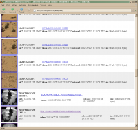
|
That discontinuity is at the bottom of the original full page, and that explains why I wasn't seeing the sol 25 images.
I tried this on a current version of firefox and it works fine. So unfortunately I'm stuck with this (until I upgrade from firefox 2.0.0.20!).
Posted by: fredk Oct 29 2012, 10:09 PM
Posted by: jmknapp Oct 30 2012, 09:48 AM
I scrape every camera/sol page regardless of the "new" flags--I think Ludo determined at one point that the flags are not reliable.
Posted by: ronald Nov 17 2012, 08:10 PM

Neither Joes nor Ludos sites do work since they changed something over at the Nasa raw images web page. Browsing for images there is really unpleasing and sometimes confusing.
HELP!
Posted by: mhoward Nov 17 2012, 09:53 PM
Yes, the view-by-sol functionality on the raw images site is basically broken as of today. If you view images by sol and save the page data, the saved file won't include any image data. I think it probably has something to do with the sol selector functionality (maybe that's new?).
Also, the page for sol 100 currently isn't even showing all sol 100 images. Oddly, http://mars.jpl.nasa.gov/msl/multimedia/raw/?s=100 doesn't show all the images, but adding http://mars.jpl.nasa.gov/msl/multimedia/raw/?s=100&camera= seems to work correctly. At the moment.
So, the simplest workaround for those of us trying to get data from these pages seems to be to view by instrument and sol, or add "&camera=" to your query.
Posted by: jmknapp Nov 17 2012, 10:49 PM
Yep, looks like they've made some changes, jquerying things up quite a bit, and the usual scrape urls by sol don't work. E.g., it used to be that scraping this url:
wget -O xyzzy http://mars.jpl.nasa.gov/msl/multimedia/raw/?s=100
...would get you a file xyzzy with all the sol 100 images in the html, but now it doesn't, you just see the jquery command.
Anyway, going through the code that is retrieved using the above, I see that this is the magic jquery incantation to get the files:
$("#listImagesContent").load("../../admin/modules/multimedia/module/inc_ListImages_Raw.cfm?s=100");
Accordingly, this wget command works as a replacement:
wget -O xyzzy http://mars.jpl.nasa.gov/msl/admin/modules/multimedia/module/inc_ListImages_Raw.cfm?s=100
Bottom line, I think it's working again. The detail above is for the benefit of Ludo or others trying to scrape the raw image pages.
Posted by: ronald Nov 17 2012, 11:06 PM
BIG thanks!
Posted by: mhoward Nov 17 2012, 11:19 PM
Again: ?s=100 isn't returning all the images. ?s=100&camera= is.
Just FYI.
Posted by: fredk Nov 18 2012, 03:27 AM
Thanks a lot for quickly getting your site working again, Joe! It's such a nice way to browse the new images.
Posted by: Stellingwerff Nov 18 2012, 09:22 PM
Hi All,
My site has been fixed as well. This did show some lack of robustness which I'll fix in the coming period.
Greetings,
Ludo.
Posted by: Stellingwerff Nov 19 2012, 08:34 AM
Aj, my "trick" to find the newest sol doesn't work correctly at this time, seems like a bug on the JPL side. Basically I'm calling:
http://mars.jpl.nasa.gov/msl/admin/modules/multimedia/module/inc_ListImages_Raw.cfm?camera=&s= (used to be http://mars.jpl.nasa.gov/msl/multimedia/raw?s=)
which defaulted to the newest sol, but that link is still only showing sol=101 images, i.s.o. the 102 images.....
Looking for a new trick.... (Maybe going back to scraping the html of the front page to get the highest sol number?)
@jknapp: what are you currently using?
Stay tuned!
[Edit: As we speak it returned to the expected behavior, maybe a caching issue?, still need to make this more robust, tho]
[Edit 2: @MidnightMartian, Thanks a lot, yes you are very right about needing the camera parameter, they seems to have added a filter removing downsamples/thumbnail images for which a full exists]
Greetings,
Ludo.
Posted by: mhoward Nov 25 2012, 08:37 PM
Heads up: the previously mentioned trick of using inc_ListImages_Raw.cfm seems to no longer be working; at least, at the moment, it's not returning the latest full frame sol 107 Mastcam images, instead still showing some thumbnail versions. I'm not going to look into why, I'm just going back to the regular website for now. (Using inc_ListImages_Raw.cfm was nice and fast, but otherwise not essential... I hope.)
Posted by: jmknapp Nov 25 2012, 10:02 PM
I think it's working for me, using wget. I'm getting 293 total mastcam images for sol 107 right now, which matches the count on the official site.
One weird thing about the trick you mentioned before of having to add "&camera=" to the url--using a browser (Chrome), I see that that gives different results, but for some reason wget gets the correct file regardless.
Posted by: kemcab2012 Nov 26 2012, 07:29 PM
Not sure if this is well known or not, but looking at the source for the page, I see that each individual sol link on the main page does the following when clicked:
-change the class of the button to selected from non-selected
-Make a call via jQuery to retrieve the contents of inc_ListImages_Raw.cfm using the specified GET parameters (which in that case is just "s=")
-Load the contents of the response from the above call into the div tag with the listImagesContent id (which is the main content screen on the main site).
Also, the cfm file is in another directory from the main site. While the thumbnail images use absolute urls to acquire the images, the raw, full-sized images are accessed via relative links, and are therefore unavailable when a user clicks on the cfm link directly.
I also made two requests to the cfm file - one with "camera=" and the other without. I then saved the source of each request. When I ran a diff between the two files, the one called via "s=" had an extra line with the following contents:
<div class="TotalRawImagesNote" >Total for Sol 107: 373 Images</div><br clear="right">
I hope the above information helps.
Posted by: iMPREPREX Nov 26 2012, 08:30 PM
I really liked the Curiosity RAW GET program.
Can that program be updated to work with the current configuration on the NASA/JPL site?
I love your site too, Stellingwerff. I just don't know my wget and all of that, so I can't mass-download 
I know I should learn...
Hate being an amateur, but I love making panoramas!
Posted by: fredk Nov 30 2012, 10:47 PM
Joe, maybe something's changed again on the jpl site? http://curiositymsl.com/table/view/ isn't showing some new sol 113 images...
Posted by: jmknapp Dec 6 2012, 10:37 AM
Sorry--missed that post. I think things are working OK now, including--drum roll...
Meta data!
The MASTCAM and HAZCAM images now have camera-pointing info, e.g., "bearing 52.58° (NE), elevation -14.66°." There may be a lag of some hours before the most recently-taken images get the pointing info, but most that are over a day old will have it.
It seems to be accurate based on rough eyeballing and when a more absolute reference is available (like the Sun) it comes in dead on, so I'm fairly confident of the accuracy.
Obviously it'd be nice to have pointing info for the navigation cameras too but for some reason at the moment I'm getting some spurious results for the NAVCAMs.
Posted by: fredk Dec 6 2012, 03:18 PM
Pointing info - that's fantastic!
Are you going to let us in on where you get that?
Posted by: Ant103 Dec 6 2012, 03:30 PM
Huh, metadata infos, that's great
But, how did you get these infos ?
Posted by: jmknapp Dec 6 2012, 03:59 PM
The pointing info comes from SPICE kernels used with the NASA NAIF toolkit CSPICE. Post-landing MSL kernels haven't been put on the main NAIF ftp site to date because "their production does not yet contain all telemetry data that we need, resulting in CKs with many gaps and all kernels lacking actual data during motion and appendage articulation periods." CKs are the camera pointing kernels. However, the team does put out some form of MSL surface kernels twice per sol that they use for rough planning and operations I guess. That's what I used to get the pointing info.
It's interesting that Google Mars now shows the current traverse as a path on the map & I notice that it's exactly what I get from the MSL SPK kernels (those kernels have the position information), so evidently Google is tapped into that source.
Posted by: mhoward Dec 6 2012, 04:37 PM
So does that mean that the current data isn't on the public FTP site? Because I still don't see it there.
Posted by: mcaplinger Dec 6 2012, 05:10 PM
http://naif.jpl.nasa.gov/pub/naif/MSL/misc/icarrasco/ I'm guessing.
Posted by: mhoward Dec 6 2012, 05:31 PM
Thanks. I'd missed that one. It looks likely.
Posted by: jmknapp Dec 6 2012, 05:52 PM
That's it. I sent an email to a NAIF guy to see if it was OK to post the url, which it probably is, but now that's a moot point!
There's no readme file in that directory so here's a description of the files for anyone interested:
http://curiositymsl.com/mslkernels.txt
Posted by: mcaplinger Dec 6 2012, 06:46 PM
How could it be not OK to post a public URL? Hopefully they weren't relying on security by obscurity to hide this information.
BTW, for those wanting to develop software and not familiar with SPICE, once you have all the right kernels loaded, a single call to pxform will produce a rotation matrix that will transform a vector from one frame (say, MSL_MASTCAM_LEFT) to another (say, MSL_LANDING_SITE). See http://naif.jpl.nasa.gov/pub/naif/toolkit_docs/C/index.html (though I like to use pyspice -- https://github.com/rca/PySPICE )
Posted by: jmknapp Dec 6 2012, 07:00 PM
Myself, I rarely get through a day without some security through obscurity. Not like everything is nuclear secrets!
True enough, or MSL_MASTCAM_LEFT to MSL_TOPO anyway--here's a C program that I used:
http://curiositymsl.com/campoint.c
Posted by: mhoward Dec 6 2012, 07:18 PM
Well, it's public info for the moment anyway. But even in plain sight it's probably still pretty obscure.
Thanks for the example, Joe. Guess I know what I'll be doing today.
Posted by: elakdawalla Dec 6 2012, 09:44 PM
I just exchanged email with Michelle Viotti. She said that they are running a couple of test projects, one of them with Ames (which explains the Google Mars part), with the goal of putting the metadata out via JPL's website publicly in the future. No time frame given.
Posted by: jmknapp Dec 7 2012, 11:05 AM
Got this from Boris Semenov:
Posted by: mhoward Dec 8 2012, 08:49 PM
Yep - that'll work.

|
Posted by: jmknapp Dec 8 2012, 09:05 PM
Nice... So are you getting reasonable results for the NAVCAM images too? I'm getting somewhat random pointing data for them.
Posted by: mhoward Dec 8 2012, 09:53 PM
I'm getting good pointing data for Navcam as far as I've seen so far, but I'm taking a slightly different approach. What I need is the rover-relative camera mast az,el, and the rover orientation quaternion; that's what I've got for MER and it makes sense for what I'm doing. So, my approach so far is:
1) Calculate the ephemeris time from the UTC time stamp from the raw images page using str2et_c.
2) Calculate the encoded SCLK from the ephemeris time using sce2c_c.
3) Get the camera mast az,el in two steps using ckgp_c:
// FRAME_MSL_RSM_AZ = -76202
ckgp_c(-76202, esclk, 0, "MSL_RSM_ZERO_AZ", cmat, &clkout, &found);
// ... pull out the azimuth in a way similar to your code example ...
// then get the elevation
// FRAME_MSL_RSM_EL = -76204
ckgp_c(-76204, esclk, 0, "MSL_RSM_ZERO_EL", cmat, &clkout, &found);
// ... pull out the elevation, and there you go.
There's probably a simpler way to do it, but I don't know how, I just started learning CSPICE yesterday.
I'm getting those rover az,el values from msl_surf_rsm_tlmenc_spanned.bc. I have no idea if that's the correct file, but it seems to be working for the moment. (Edit: some time later, it turned out that msl_surf_rsm_tlmres_spanned.bc is better for what I'm doing. msl_surf_rsm_tlmenc_spanned.bc does not seem to be accurate enough when it comes to exact placement of M-100 images.)
Actually the problem I'm having is with ChemCam. I get wrong values there, and no idea why. For starters, the time stamps on ChemCam images on the raw images page don't seem to match up with the rover clock value in the filenames, so... who knows. That's a problem for another day. Now I need to figure out how to pull out the orientation and position information.
Sorry if that doesn't help, but at least it indicates that there is good data along the line somewhere.
Posted by: mcaplinger Dec 8 2012, 10:29 PM
Do you separately account for the slight pointing differences between the cameras on the RSM and the RSM itself? If not, that will cause small errors, though maybe not enough to matter for your application.
pxform with the appropriate frames should give you what you want without the need to compute the SCLK (ckgp is an older, lower-level routine) but if ckgp works, no reason not to use it.
Posted by: mhoward Dec 8 2012, 10:49 PM
I haven't gotten quite that far yet, but I hope to. I was having problems with the values I was getting from pxform, but it's entirely possible I just haven't figured out how to use it yet.
Posted by: jmknapp Dec 9 2012, 01:29 AM
Just figuring these MSL files myself, but as I understand it, the "spanned" version fills in the gaps between actual telemetry (TLM) data with interpolated values. The other version has the gaps, so SPICE calls will throw an error for those times.
The "runout" files are intriguing because according to the http://curiositymsl.com/mslkernels.txt they project 10 years (!) into the future, to be "used for predicted applications." They don't appear to have any future data at this point though, they just leave the rover at the last position for 10 years. Wouldn't it be nice to see where they're planning to go!
They do have the rover's position up to the current location, updated twice daily, so that allows a track to be made:
|
http://curiositymsl.com/track.jpg
That link updates every hour or so to show the current position.
Posted by: fredk Dec 9 2012, 02:33 AM
Oh man, that's cool, Joe! Does this mean you've put our resident map makers out of work? 
Edit: comparing with Phil's map, there are obvious offsets, though maybe those are due to translating rover location coordinates into positions on the orbital image. That would mean understanding the image projection.
Still, you've really outdone yourself here!
Posted by: jmknapp Dec 9 2012, 01:10 PM
Looks pretty close to the http://mars.jpl.nasa.gov/msl/multimedia/images/?ImageID=4915 and Phil's. As I understand it, the HiRISE map-projected image is an equirectangular projection, where lines of longitude and latitude have equal spacing. The SPICE MARS_TOPO frame is cartesian, with the origin at the landing site, Z up (zenith), X to the local north and Y local west. MARS_TOPO is more practical than lat/lon IMO because the coordinates can be in meters (as in Y meters east and X meters south of the landing site). I think (could be wrong) that while these aren't exactly similar projections, at the scale of the area so far and so close to the equator, they're within maybe a meter at any given point when they're registered to a best fit.
It's lacking the placenames and waypoints of a proper map, but I was thinking of incorporating something like it in the raw images listing, just to provide a context for a given image--an icon to click on or maybe hover over to bring up the map.
Posted by: jmknapp Dec 17 2012, 02:55 AM
OK, another feature update related to mapping--the image listing on http://curiositymsl.com now has a "map it" link associated with each image. Clicking on it brings up a page with a map showing the rover position on the left hand side, and the associated image on the right. If camera pointing information is available (currently only for MASCAM and HAZCAM images), an arrow on the map indicates the direction.
Here's an example of the "map it" page for an image without pointing info, http://curiositymsl.com/imgpoint.php?name=NLA_408954917EDR_S0051576NCAM00535M_
...and with pointing info, http://curiositymsl.com/imgpoint.php?name=0106ML0681003000E1_DXXX
Posted by: elakdawalla Dec 17 2012, 03:29 AM
Wow. That is awesome.
Posted by: walfy Dec 17 2012, 03:48 AM
Way beyond my wildest dreams. What a wonderful reference! Usually had to work my brain to guess which way I was looking. Fantastic coding wizardry! Deepest thanks.
Posted by: Poolio Dec 17 2012, 06:18 AM
Amazing. I have often struggled to map images to terrain. With this, each location on the map has an immediate sense of place, making the stops on the journey that much more vivid and tangible. I think I have a new favorite website. Thank you for this.
Posted by: CosmicRocker Dec 17 2012, 06:23 AM
Joe, this is incredible and extremely useful. Thank you, thank you.
I don't want to sound like a spoiled kid asking for more after getting a nice Christmas present, but would it be possible to do the inverse, where one could click on a map position to bring up a page of images taken from that position?
Posted by: Stu Dec 17 2012, 09:01 AM
That is fanTASTIC, thank you! Really brings Curiosity's mission to life.
Posted by: Explorer1 Dec 17 2012, 09:12 AM
That's amazing Joe, bookmarked!
Presumably the map will get extended as the rover moves beyond the borders?
Posted by: jmknapp Dec 17 2012, 02:10 PM
I just wanted to get a better sense of the context myself, particularly a side-by-side view of map and image--that's really the sweet spot, absent a totally immersive 3-d visualization only a few years away down the road surely!
The main thing bugging me now is that for some reason I'm not getting accurate NAVCAM pointing info from the NAIF data files, don't know if it's user error or what. With a 45 degree field of view the NAVCAMs really give a good context. I keep getting that the NAVCAMs are pointed about 40 degrees down and the azimuth isn't right either. It's weird because the calculation for the MASTCAMs is very similar and they are all fixed to the mast pointing more or less in the same direction.
Knowing the CHEMCAM pointing would also be very useful as it's usually very hard to figure out what rock it's looking at. But that data comes out squirrelly too at the moment.
I can add more map tiles to expand the area covered, but as of now unless Curiosity heads deep into Yellowknife Bay to the east, I think it's due to turn around and head more or less southwest, so I think the current map will be good for months.
As for clicking on the track and getting some sort of display of images from on/near that location, I guess Mars geeks think alike, because I was thinking the same thing. There are a few edge cases to consider. Like how about if the rover moves 1cm--is that a new location? The maximum scale of the map is 0.25 meters per pixel.
One funny thing I noticed: the sequences of NAVCAM thumbnails seen occasionally are taken when the rover is moving, or at least in the middle of the traverse, Also, haven't looked at the extremely fine detail yet (maybe it isn't even totally valid for these preliminary files) but the track seems to indicate that the rover travels in a fine-scale zig-zag pattern occasionally.
Posted by: Greenish Dec 17 2012, 03:32 PM
Joe, thanks again for your continued improvements and contributions. It's a great tool and really helps makes the place come alive. For the true amateurs like me it really helps interpretation too since I spend less time wondering which way is up.
Regarding the suggestion to expand the map, I think having even a lower-res larger area map behind the current one would be useful for identifying far-off features in horizon images. But since you've provided pointing and location data that's no longer needed to triangulate position.... and most of the time is spent looking down at the local area anyway.
What I'd find somewhat useful, and perhaps simpler to implement than reverse-map-lookup is a graphical interpretation of the field-of-view - i.e. a wedge around the arrow that's 5.1 deg wide for MR, 16.8 wide for ML etc. I know that depends on camera pitch, whether the whole image width is used, etc. But really it's all icing on the cake at this point.
Posted by: fredk Dec 17 2012, 03:35 PM
Let me add to the chorus - this is insanely cool.
About clicking on the map to get a list of images taken near there, that strikes me as not extremely useful, since we can simply read the corresponding sol(s) from a route map and view images from that sol(s). Maybe the idea is that this would automatically select the sol range if it's more than one sol? Also, as you point out, (as with MER) there are mid-drive navcam images that could be found this way.
But here's what would strike me as really useful: Click on two points on the map. The first one selects the rover position, and the second defines an azimuth. (So the 2nd defines only a unit vector, not a distance.) Then you could return a list of images from that rover location, looking (within some preset +/- azimuth range) towards the selected azimuth.
In principle this could be extended to image elevation as well, ie you could somehow specify an elevation and then the returned images point near that elevation (and previously specified azimuth). Though it's not clear how you'd specify that...
Posted by: mhoward Dec 17 2012, 03:54 PM
Joe: Just to make sure you're aware, in the engineering rawids characters 19-21 is the site counter and 22-25 is the drive counter. It works similar to MER; you've probably seen the relevant papers. You can determine which locations are significant by counting the number of images in whatever way you like. Occasionally you'll have non-driving locations that are close enough together you might want to combine them, but not often.
Posted by: jmknapp Dec 18 2012, 01:24 AM
Thanks for the tips and suggestions. No, I wasn't aware of the siteid/driveid thing.
Greenish's suggestions are good and have the virtue of being pretty simple to implement. The map now ahows an FOV wedge when the pointing info is available. The wedge extends out far irrespective of the elevation, so the actual range of an image needs to be taken into consideration/guesstimated based on the given elevation and terrain.
Also, I added a layer with a mosaic of the NW quadrant of Gale Crater from the MRO CTX camera. Note that it doesn't appear until you zoom out pretty far. It's slightly misregistered--I'll tweak that eventually.
Posted by: atomoid Dec 18 2012, 03:22 AM
That's absolutely amazing! i hope they pay you enough!
a glutton might whine for even more tasty morsels, so ill try:
filter by: bearing, elevation, SOL range,
regarding the "clicking on the map to get a list of images taken near there", id see the usefulness of clicking on the map itself rather to find images that have that point in their view, and filter as desired to reduce the hit list, especially if an elevation map could be used in the plot to eliminate images where the point is out of view behind a rise. would be nice to have an easy way to find images of various features from various angles, near or far.
Posted by: stewjack Dec 18 2012, 03:51 AM
This new fangled concept of being confident of the direction that you are looking out from the mast towards -
is going to take some getting used to! At least as long as there is no pointing information associated with the
Navcams I can claim that it was because I was looking at the Navcams, that I became disoriented. Otherwise -
I wouldn't have ANY excuse!
Posted by: jmknapp Dec 18 2012, 02:48 PM
Figured out the problem with the NAVCAM pointing--fixed:
http://curiositymsl.com/imgpoint.php?name=NLA_408954917EDR_S0051576NCAM00535M_
No excuses...
Posted by: stewjack Dec 18 2012, 08:22 PM
Oh My!

Posted by: maschnitz Dec 18 2012, 08:34 PM
Oh, Joe, doing your own site, for free - no apologies or excuses needed. Stuff happens. We're lucky to have your work.
And, great work lately. Keep it up!
Posted by: atomoid Dec 19 2012, 01:10 AM
just a tiny gotcha:
it seems the 'SOL' setting snaps back to 'all' whenever i select any of the MASTCAM NAVCAM CHEMCAM HAZCAM MARDI MAHLI boxes.
or maybe its just a quirk in Chrome, i haven't checked others..
you do realize Joe, that yourself and others are constructing a Mars geeks' paradise ?!
Posted by: eoincampbell Dec 19 2012, 01:12 AM
Thanks to Joe for the "go-to-site" for Curiosity images. Sitting-in through it's development here is awesome btw.......
Posted by: jmknapp Dec 19 2012, 06:36 PM
The reason the sol list snaps back to all is that only sols that have images, given the current selection of cameras, appear in the list. When you uncheck a camera it could very well happen that there aren't any images for the given sol. So in all cases it resets to all and recalculates the list of sols that have images. Granted, maybe it could be done a little more user-friendly and it annoys me sometimes too. Until I change that, the thing to do is make the camera selections first and then select sol, order, size, etc. at will.
As for getting a set of images in more or less the same direction and location as a given image, yes, that sounds very useful!--but tricky. It would be great for figuring out CHEMCAM targets. I hate to think of a clunky interface where you have to specify az/el and location bounds, database-query style. What I'm thinking is maybe a more immediate interface where you simply click on a pixel in a displayed image, the software figures out the azimuth, elevation and location of the camera at that pixel, and then gets the set of all images from the same location that contain that az/el vector. The latter step is actually not too hard in SPICE--you just rotate the vector from the topo frame to the camera frame and check whether it's in the field of view. Maybe the returned images could each have a marker at the given direction.
A tricky part is that many images are not full size. Some are just scaled down versions which wouldn't be a problem, but others are sub-framed and it's not clear what part of the frame they're taken from. Maybe in most cases the center of the sub frame corresponds to the center of the full frame? If some false positives and negatives are tolerated maybe it wouldn't be half bad.
Posted by: jekbradbury Dec 20 2012, 05:58 AM
With Navcam images, one thing you might be able to do is to overlay on the map (in a different color) clickable wedges for other Navcam images produced at the same location. If two panorama rows were taken at the same site at different elevations, only those wedges corresponding to images at the same elevation should probably be displayed.
Posted by: Airbag Dec 29 2012, 01:52 PM
jmknapp's curiositymsl.com is not working for me today - it goes to a generic RoadRunner "what are you looking for?" web site instead. Is anybody else having the same problem? Ludo's "MSL Curiosity - Raw Images Listing" has not shown any updates for a few days now. I may <gasp> have to go to directly the NASA site instead!
Airbag
Posted by: Tesheiner Dec 29 2012, 02:07 PM
Nope. It's working for me.
Posted by: jmknapp Dec 29 2012, 02:12 PM
A little glitch there... just fixed it a few minutes before you posted.
Posted by: Airbag Dec 29 2012, 02:21 PM
Thanks!
Airbag
Posted by: Stellingwerff Dec 29 2012, 08:16 PM
Working on it:) Backend on Google App Engine became way to expensive, so I decided to move to Amazon WebServices.
Early birds preview: http://msl-raw-images.com/
I do expect some refresh issues there, but it should basically be working now. I will replace the old site with a notification/redirection page as soon as possible. Twitter services will resume as soon as the new site is finished. (Just testing now, so couple of hours on most)
Greetings,
Ludo.
Posted by: jmknapp Dec 30 2012, 07:32 PM
Thinking about different ways to torture the SPICE camera-pointing data, here are a couple of charts showing the mast pointing during the course of one sol, sampled every second:

|
That's from sol 137 when mastcam pans were done.

|
From sol 141 which included some navcam shots skyward.
Maybe of limited usefulness, but kind of fun to interpret.
Posted by: mhoward Jan 7 2013, 08:03 PM
For Mac and (to a limited extent) iOS users, I'm making some alpha software available today. 'Alpha' means an early development version. Please note that this isn't finished (in fact it still has a long, long way to go), but I figure a few of the diehard enthusiasts here might want to know about it and follow along as it continues to evolve:
http://www.midnightplanets.com/alpha/
For everyone, my website now includes recent image updates, for Opportunity as well as Curiosity. (And since we have metadata for Opportunity, you can see observation descriptions when you click on an image.)
http://www.midnightplanets.com
- Mike
Posted by: phase4 Jan 7 2013, 09:04 PM
Amazing! It runs incredible smooth and loads images very fast. (mbp)
And an option to toggle between MSL/Opportunity a dream just got real.
Thank you mhoward.
Posted by: eoincampbell Jan 8 2013, 01:21 AM
Great, MacMini loves it! Thanks.
Posted by: mhoward Jan 14 2013, 01:03 AM
I'm not usually going to post about updates, but some of you might enjoy http://twitter.com/PAL9000MP, which I think is working now. You can also get text message notifications sent to your cellphone if you set that up in Twitter.
Posted by: pospa Jan 14 2013, 03:59 PM
Dear Joe, I like your CuriosityMSL image browser a lot and would like to suggest a small improvement to yout consideration.
Could you add one more column "Total distance traveled" into the Drive Log page? This value would show cumulative distance traveled since landing for every sol.
Thx
Posted by: jmknapp Jan 14 2013, 08:23 PM
Good idea--Greenish was thinking that rover azimuth (before and after the drive) would be good, as well as elevation change. Another item of interest would be the rover tilt (roll, pitch). I'll add all those columns if it will all fit horizontally in a reasonable space.
Posted by: jmknapp Jan 16 2013, 11:09 AM
OK, I updated the rover http://curiositylog.com to include more data. Also, thanks to Ludo for getting me straightened out with MAHLI pointing, so now the MAHLI images have azimuth and elevation info.
Although it'd be nice to be able to take a CHEMCAM or MAHLI image and automatically identify the location in a MASTCAM or NAVCAM image, turns out there's a problem, which I think is due to parallax between the camera locations. That is, if you take, say, a CHEMCAM pointing direction and try to find a MASTCAM image that contains that direction, things don't quite line up. It gets you in the ballpark, but you have to visually search to find the corresponding spot. Parallax effect? That would be especially pronounced for MAHLI, at the end of the robotic arm. I think that a 3D model of the scene is required to really do this automatically.
Posted by: elakdawalla Jan 16 2013, 04:34 PM
Earlier in the mission, ChemCam images were almost always taken with a left Navcam for context -- but I guess once they got confident in ChemCam pointing they stopped doing that. I'm a little surprised that left Navcam pointing is different enough that geometry doesn't match between left Navcam and ChemCam -- but I'm not too good at imagining spherical coordinates, so it's also not surprising that I'm surprised!
Posted by: elakdawalla Jan 16 2013, 04:36 PM
I just want to make a more general comment on this thread that I love the proliferation of different ways to display these data. I have no favorites -- I find jmknapp's useful for some circumstances, mhoward's for others, stellingwerff's for others. The addition of Twitter feeds of drive data and image download data is super. Keep the great work coming
Posted by: jmknapp Jan 16 2013, 05:09 PM
Here's an example--using the "http://curiositymsl.com/gallery/cc157.html" CHEMCAM image and correlating it with a left NAVCAM image:

|
The red circle is automatically generated and the green circle is the actual location. That's with NAVCAM with a 45 degree fov--the shift is more dramatic with MR & ML.
The CHEMCAM lens looks to be a few inches above the left NAVCAM.
Posted by: mhoward Jan 16 2013, 05:12 PM
I'm seeing basically the same thing at the moment. Was just about to look into what's going on.
Posted by: Gerald Jan 16 2013, 07:08 PM
I agree, that you get a parallax, whenever the cameras are not on the same line they are pointing to.
With MAHLI there might be a chance to get pretty close to a match, whenever you can transform the NAIF MAHLI position to the Mastcam coordinate system. MAHLI often will be so close to the object it takes the photograph of, that it might be used as an approximative of the 3D position of the object.
When both cameras are more distant from the object, it may help to assume several distances of the object as a loop, magnify the taken pictures in a way corresponding to the assumed 3D position, and try an automatic stitch as a subroutine within the loop. If one of those stitches works, you may retrieve the log data of the stitching software to get a best candidate for correspondance. If the parallaxe is too large, this may work best with sub-images.
The good thing is, you need to search just one-dimensional, if camera positions are precisely known.
This approach may work, if the image shows sufficiently unique features, objects are sufficiently smooth, and are within some other geometric constraints to be well visible from both cameras. The principle will be almost the same as used for the visual odometry of MSL.
As a side-effect you may get a good approximation of the 3D-pos of the imaged object. Fully developped even a rough 3D model of the imaged surface could be interferred, but the latter can become rather difficult in practic (therefore the MSL morse in the wheels for visual odometry in poorly structured dust).
Just an idea to come closer to an automatism, but it's hard stuff to implement and has to be tested how well it works with real images.
Posted by: fredk Jan 16 2013, 07:36 PM
The size and direction of the offset in your navcam-chemcam example, Joe, are crudely what you'd expect from parallax. For a 1.9 metre navcam height and target elevation of about -33 degrees, the target is about 3.5 metres from the cameras. A L-R navcam separation of 42.4 cm gives a NLA-chemcam separation of about 16 cm. Trig gives an expected parallax of 2.2 degrees. Your green and red circles are separated by about 3.0 degrees.
Not only is the separation not perfect (though distance uncertainties will contribute to that), but more seriously the offset direction is not good. Chemcam is not vertically above NLA, it is at an "elevation" of roughly 45 degrees, towards the centre of the mast. So the chemcam target bearing should be to the lower left of the navcam bearing, regardless of target position. But your red circle is directly below your green.
Can you repeat this with more chemcam/navcam pairs? Is the chemcam bearing consistently offset, in angular distance and more importantly direction, from the navcam bearing, or is there some random scatter? That should be a clue...
Posted by: mcaplinger Jan 16 2013, 07:55 PM
MAHLI is obviously a more involved problem than Chemcam because of the much larger baseline.
Are you using the individual instrument frames or the RSM frame? If the latter, the boresights of the instruments on the RSM are not especially parallel; the Mastcams are toed-in relative to each other by about 2.5 degrees IIRC.
Posted by: jmknapp Jan 17 2013, 01:23 AM
Wow, some interesting ideas there, particularly that the position of MAHLI is often very close to the object, so it's a 3D probe... that's one point in space anyway. As for being repeatable, there may be an issue there--never discount the possibility of programming errors or SPICE inaccuracies, not necessarily in that order. Here's another example that might indicate something else going on:
Take this CHEMCAM shot of a calibration target: http://curiositymsl.com/imgpoint.php?name=CR0_411084181EDR_F0051954CCAM02153M_
Here's the result of a http://curiositymsl.com/imgpoint.php?name=NLA_411431900EDR_F0051954NCAM07504M_ on a NAVCAM image:

|
Again, red is the automatically generated position and green the actual. So in this case it's off more to the left. Spherical geometry makes my head hurt too, but it's hard think of why the direction would be so variable--it's not like the rover is tilted so much. Of course, the calibration target is very close, so any parallax is that much greater.
mcaplinger: I use pxform_c() to get the actual instrument pointing, so at least things like toe-in should be accounted for.
Posted by: pospa Jan 17 2013, 12:09 PM
Thanks Joe! I just noticed one small bug in column UTC: on each line there is JANuary for month value, from sol 1 till 159. Nothing critical, just a little inperfection to fix by next upgrade.
Thank you again for all this your effort.
Posted by: Gerald Jan 17 2013, 12:19 PM
If you are ready for some math, the focus-stacked MAHLI case most likely becomes feasible in a determinstic and reproducible way:
For this I have to assume, that SPICE data are reliable; I'm optimistic, that this assumption mostly holds, because otherwise the MAHLI close-ups weren't possible.
To understand the geometry of the imaging sufficiently for a match of two images, we have to think at least 7-dimensional (degrees of freedom): Three dimensions (x,y,z) for the position of the camera relative to a frame (coordinate system), three rotational dimensions (heading, pitch, yaw), and at least one dimension for the aperture.
To understand the relative positions and rotations in space, the first six are needed. These six dimensions describe the transformation from one frame to a second. The inverted transformation describes the transformation from the second to the first frame.
In the case of two cameras we have to look at three frames (in the most simple case): Frame of camera 1, frame of camera 2, and frame of e.g. MSL.
To transform frame cam 1 to frame cam 2, we have to take the inverted transformation MSL->cam1 and multiply (matrix multiplication provided by software library) to this the transformation MSL->cam2.
Now take MAHLI as cam1. From focus stacking we (hopefully) know the focal length focus distance for each pixel. The focal length focus distance in many cases will be very narrow at the distance of the 3D-point of the object from the MAHLI frame origin. By the pixel position within the MAHLI image and the MAHLI aperture, we get the missing two dimensions of the 3D-point within the MAHLI frame.
Now apply the MAHLI->cam2 transformation to the 3D-point, and you get the 3D-position within the cam2 frame. By the cam2 aperture you may project the 3D-position into the image plane of cam2 and get the pixel pos (Check for division by zero). Now range check.
Doing this for the four corner points of the MAHLI image you get the endpoints of a morph from MAHLI to cam2.
Hopefully the discrepancy between the red and the green circle will almost vanish with an accurate calculation based on all degrees of freedom. Probably the parallaxe is just the distance between the (z?-)axes of the two camera frames, if pointings are identical; also check apertures.
Posted by: jmknapp Jan 18 2013, 01:41 AM
I think I follow that--taking aperture to be field of view? So would the MAHLI distance be derived from the height map that they make from multiple images/focal planes?
Posted by: Gerald Jan 18 2013, 11:19 AM
That's exactly what I meant.
I'm looking forward to your results. Thanks for investing your time for doing that! I think, we all will enjoy your work very much.
Posted by: mcaplinger Jan 18 2013, 03:13 PM
Be warned that the current MAHLI depth maps are not calibrated for distance and we aren't giving you the focus mechanism positions for each frame, so it would be tough to back this out.
For RSM instrument boresighting, I find it hard to believe that the offsets you're seeing are purely parallax (as noted they are in the wrong direction) but this is something I'm just starting work on so I could be mistaken.
Posted by: jmknapp Jan 18 2013, 10:21 PM
That was going to be my next question.
We will all enjoy that work very much, Mike!
Posted by: Gerald Jan 19 2013, 12:50 AM
Thanks for this info! So we have to look for a way to do a depth calibration. This won't be quite trivial.
There might be a way to reconstruct/guess the focussing heuristics; e.g. a hyperbolic interpolation of the type D = C + A / N, for N = N_min..N_max, and some constant distances A and C.
If the heuristics cannot be retrieved in a straightforward way, we'll need a somewhat fuzzy optical technique.
One idea for that might be the simulation of the optical blur of single (lo-res) images from the sharp focus-stacked image. Via difference image and a chi-square method (minimizing the sum of the squares of the difference pixel values of the examined region) and constraints known of the focussing heuristics we could try to find out the most likely focus distances.
That's just a first idea and has to be elaborated in more detail, if necessary.
Posted by: mcaplinger Jan 19 2013, 02:49 AM
My suggestion is to wait until the PDS archive data are available so you don't have to guess. We have enough trouble figuring out the range as it is. By that time it may be that the JPL stereo mesh products will be available (I don't know if those get archived to PDS or not); if so, you will know the range out to 20 meters or so for each site. I'm also not sure what you have to gain; usually you can tell where MAHLI is looking just from looking at where MAHLI is in Navcam images, and you can tell where MAHLI is in the rover frame from the SPICE data.
If people still want to look at this, the MAHLI paper has some focus/range plots and all Z-stacks are taken with constant motor count stepping (but I'm still not sure if absolute range can be backed out, at least without some measure of scale.)
Posted by: Gerald Jan 19 2013, 12:36 PM
Thanks, that's perfect! All infos we need.
And thanks for your hard and excellent work!
EDIT: For technical data see http://www.researchgate.net/publication/221673906_Curiositys_Mars_Hand_Lens_Imager_(MAHLI)_Investigation, especially section 6.5 on p. 25f, and Fig. 27 on p. 102 of the submitted version.
Posted by: Greenish Jan 19 2013, 12:37 PM
Won't be too long now, according to http://pds-imaging.jpl.nasa.gov/ , "The first MSL release for EDRs is expected on February 27, 2013; the first release for RDRs is expected on March, 20, 2013."
Posted by: Deimos Jan 19 2013, 07:47 PM
I grabbed those images and ran my own models. I looked at where the center of the CCAM FOV was in the NCAM image for a set of assumed distances (every 10 cm to 100 m). Your red circle is near where I see the far end of that projection. The projection goes through your red circle just shy of 1.6 m. Repeating for the NCAM right eye, it also goes through that target shy of 1.6 m (from CCAM entrance aperture).
In the left eye, the projection enter from 1/3 down the right hand side of the image. In the right eye, the projection enters about 1/4 up the left hand side of the image, with the far end firmly in the RTG fins.
So the effect seems to be purely parallax from the vertical + horizontal offset of the cameras, with the left eye having a stronger vertical component.
Posted by: jmknapp Jan 20 2013, 02:33 AM
Good to know! Thanks, deimos.
Posted by: Gerald Apr 5 2013, 02:16 PM
Explanations to http://mars.jpl.nasa.gov/msl/multimedia/raw/?rawid=0230MH0246001001C0_DXXX contain the following data points of a motor count - cm-distance - map for MAHLI with opened dust cover:
5;14360
7;13980
10;13635
15;13325
20;13155
25;13050
30;12970
By a least squares method I got this formula for a regression parabola describing the working distance in cm by motor count:
applicable for motor counts between 12564 and 15600, with care outside the 2.5 to 30 cm region, because no data points were avaiable there.
Absolute and relative errors of the formula relative to the data points are shown in these diagrams:

|
Posted by: jmknapp Apr 5 2013, 02:56 PM
Wow, that was a geeky-informative note they added to that image. Which motor does the count refer to?
Posted by: mcaplinger Apr 5 2013, 03:07 PM
There's only one motor in MAHLI, the focus motor.
Working distance to motor count is described in the MAHLI paper, figure 13.
Posted by: Gerald Apr 5 2013, 03:15 PM
It refers to the "focus motor count position" of the MAHLI camera. The distance may be useful for a 3d localization of objects we thought about earlier.
There are also provided micrometers per pixel, but less accurate. I'll see, whether I can retrieve an acceptable formula, that interpolates this second value. It may be interesting for a scaling of the MAHLI images.
All we need is the appropriate motor count. Joe, do you know how to access to it?
Posted by: Gerald Apr 5 2013, 05:20 PM
Slightly improved hyperbola formula for MAHLI distance, and formula for microns per pixel, based on http://mars.jpl.nasa.gov/msl/multimedia/raw/?rawid=0230MH0246001001C0_DXXX:
MicronPerPixel = 46836.6 / (motor_count - 12560.1) - 1.20623
Errors relative to data points below 1%:

|
Posted by: jmknapp Apr 5 2013, 07:37 PM
Like most metadata not in the PDS, I wouldn't know how to get the MAHLI information, but maybe it will be included in the MAHLI PDS release scheduled for June 6 ("release 2").
Posted by: Gerald Apr 5 2013, 11:59 PM
This is a link to an arbitrary MAHLI image: http://mars.jpl.nasa.gov/msl/multimedia/raw/?rawid=0129MH0154002000E1_DXXX&s=129.
The adress is composed of the fixed string "http://mars.jpl.nasa.gov/msl/multimedia/raw/?rawid=", the name of the jpg-file without extension, here "0129MH0154002000E1_DXXX", the constant string "&s=" and the sol number, here "129".
The referenced website containes the constant text "When this image was obtained, the focus motor count position was " plus the motor count (here "15148") plus ".". There are no html tags in that part of the html source.
By scanning (searching) for the fixed text, then reading the number until the "." it should be possible to read out the motor count.
What do you think?
Posted by: jmknapp Apr 6 2013, 12:24 AM
Huh, didn't know they had that for every MAHLI image--seems like that info could easily be scraped and converted to cm as you say. I may try that for my website. Just did a quick check & there have been 4224 MAHLI images to date, so that's a fair bit of scrapage.
Powered by Invision Power Board (http://www.invisionboard.com)
© Invision Power Services (http://www.invisionpower.com)